Mohinder S. Grewal - Global Navigation Satellite Systems, Inertial Navigation, and Integration
Здесь есть возможность читать онлайн «Mohinder S. Grewal - Global Navigation Satellite Systems, Inertial Navigation, and Integration» — ознакомительный отрывок электронной книги совершенно бесплатно, а после прочтения отрывка купить полную версию. В некоторых случаях можно слушать аудио, скачать через торрент в формате fb2 и присутствует краткое содержание. Жанр: unrecognised, на английском языке. Описание произведения, (предисловие) а так же отзывы посетителей доступны на портале библиотеки ЛибКат.
- Название:Global Navigation Satellite Systems, Inertial Navigation, and Integration
- Автор:
- Жанр:
- Год:неизвестен
- ISBN:нет данных
- Рейтинг книги:4 / 5. Голосов: 1
-
Избранное:Добавить в избранное
- Отзывы:
-
Ваша оценка:
Global Navigation Satellite Systems, Inertial Navigation, and Integration: краткое содержание, описание и аннотация
Предлагаем к чтению аннотацию, описание, краткое содержание или предисловие (зависит от того, что написал сам автор книги «Global Navigation Satellite Systems, Inertial Navigation, and Integration»). Если вы не нашли необходимую информацию о книге — напишите в комментариях, мы постараемся отыскать её.
GNSSs including GPS, Glonass, Galileo, BeiDou, QZSS, and IRNSS/NAViC,
and MATLAB programs on square root information filtering (SRIF)
This book provides readers with solutions to real-world problems associated with global navigation satellite systems, inertial navigation, and integration. It presents readers with numerous detailed examples and practice problems, including GNSS-aided INS, modeling of gyros and accelerometers, and SBAS and GBAS. This revised fourth edition adds new material on GPS III and RAIM. It also provides updated information on low cost sensors such as MEMS, as well as GLONASS, Galileo, BeiDou, QZSS, and IRNSS/NAViC, and QZSS. Revisions also include added material on the more numerically stable square-root information filter (SRIF) with MATLAB programs and examples from GNSS system state filters such as ensemble time filter with square-root covariance filter (SRCF) of Bierman and Thornton and SigmaRho filter.
Global Navigation Satellite Systems, Inertial Navigation, and Integration, 4th Edition Updates on the significant upgrades in existing GNSS systems, and on other systems currently under advanced development Expanded coverage of basic principles of antenna design, and practical antenna design solutions More information on basic principles of receiver design, and an update of the foundations for code and carrier acquisition and tracking within a GNSS receiver Examples demonstrating independence of Kalman filtering from probability density functions of error sources beyond their means and covariances New coverage of inertial navigation to cover recent technology developments and the mathematical models and methods used in its implementation Wider coverage of GNSS/INS integration, including derivation of a unified GNSS/INS integration model, its MATLAB implementations, and performance evaluation under simulated dynamic conditions
is intended for people who need a working knowledge of Global Navigation Satellite Systems (GNSS), Inertial Navigation Systems (INS), and the Kalman filtering models and methods used in their integration.
Global Navigation Satellite Systems, Inertial Navigation, and Integration — читать онлайн ознакомительный отрывок
Ниже представлен текст книги, разбитый по страницам. Система сохранения места последней прочитанной страницы, позволяет с удобством читать онлайн бесплатно книгу «Global Navigation Satellite Systems, Inertial Navigation, and Integration», без необходимости каждый раз заново искать на чём Вы остановились. Поставьте закладку, и сможете в любой момент перейти на страницу, на которой закончили чтение.
Интервал:
Закладка:
These are methods used for cancelling the effect of some sensor output bias errors on navigation errors by rotating the sensor input axis either continuously (carouseling) or discretely (indexing), effectively zeroing the inertial integral of the sensor‐fixed errors.
Carouseling was first introduced at the Delco Division of General Motors in the early 1970s for gimbaled systems, using a vertical gimbal axis for the rotation. It has also been applied to strapdown systems, using ISA rotation about a nominally vertical yaw axis, and to strapdown MEMS systems for navigation [7], and evaluated for MEMS gyrocompasses [8].
Indexing (also called “gimbal flipping”) has been used quite extensively in the US Navy's electrostatically supported gyro navigator (ESGN), using independent indexing around and end‐to‐end on the spin axes of its electrostatic gyroscopes. This indexing does not cancel the effects of rotor axial mass unbalance, but it cancels just about everything else.
3.4 Inertial Navigation Models
Besides models for mitigating sensor errors, inertial navigation systems require internal models for the external world in which they must navigate. These models define the navigation coordinates to be used, including any departures from inertial coordinates. For terrestrial navigation, those departures include gravity, rotation, and the non‐rectilinear shapes of Earth‐fixed coordinates.
3.4.1 Geoid Models
Carl Friedrich Gauss introduced the idea of a geoid in 1828 as the “mathematical figure of the Earth,” defining its shape as that of a reference equipotential surface (e.g. mean sea level), and defining locations in the near‐Earth environment in terms of longitude, latitude and altitude with respect to that geoid shape.
Geoid models began as oblate spheroids – something predicted by Isaac Newton as the real shape of the Earth – with the Earth's center of mass at its center, the Earth rotation axis along its short axis, and the Airy Transit Circle at the Royal Observatory in Greenwich at its prime meridian.
Later refinements included undulations of the equipotential surface above and below the reference ellipsoid, represented in terms of spherical harmonics. That basic concept is still in use today, and it is used for GNSS navigation. Geoid models are also used for inertial navigation. Besides providing a common grid solution for position, geoids also provide models for the near‐Earth gravitational field.
There are different geoids for different purposes. Those used for surveying generally include some model for the local vertical direction as a function of location, because the local vertical is used as a reference direction in surveying. Those used in hydrology need to include something equivalent to gravitational potential. Those used in inertial navigation need to include the local gravitational acceleration magnitude and direction.
There have been many geoid models over the years, and multiple international efforts to establish a common one. The WGS84 reference geoid was established by the 1984 World Geodetic Survey, and it has become widely used in GNSS and inertial navigation.
3.4.2 Terrestrial Navigation Coordinates
Descriptions of the major coordinates used in inertial navigation and GNSS/INS integration are described in Appendix B ( www.wiley.com/go/grewal/gnss). These include coordinate systems used for representing the trajectories of GNSS satellites and user vehicles in the near‐Earth environment and for representing the attitudes of host vehicles relative to locally level coordinates, including the following:
1 Inertial coordinatesEarth‐centered inertial (ECI), with origin at the center of mass of the Earth and principal axes in the directions of the vernal equinox and the rotation axis of the Earth.Satellite orbital coordinates, used in GNSS ephemerides.
2 Earth‐fixed coordinatesEarth‐centered, Earth‐fixed (ECEF), with origin at the center of mass of the Earth and principal axes in the directions of the prime meridian at the equator and the rotation axis of the Earth.Geodetic coordinates based on a reference geoid. Geodetic latitude, defined as the angle between the equatorial plane and the local vertical, as illustrated in Figure 3.8. It can differ from geocentric latitude by as much as 12 arc minutes, equivalent to about 20 km of northing distance.Local tangent plane (LTP) coordinates, also called “locally level coordinates,” essentially representing the Earth as being locally flat. These coordinates are particularly useful from a human factors standpoint for representing the attitude of the host vehicle and for representing local directions. They includeEast–north–up (ENU), shown in Figure B.7;North–east–down (NED), which can be simpler to relate to vehicle coordinates; andAlpha wander or azimuth wander, rotated from ENU coordinates through an angle about the local vertical, as shown in Figure B.8.
3 Vehicle‐fixed coordinatesRoll–pitch–yaw (RPY), as shown in Figure B.9.
Transformations between these different coordinate systems are important for representing vehicle attitudes, for resolving inertial sensor outputs into inertial navigation coordinates, and for GNSS/INS integration. Methods used for representing and implementing coordinate transformations are also presented in Section B.4.
3.4.3 Earth Rotation Model
Our Earth is the mother of all clocks. It has given us the time units of days, hours, minutes, and seconds that govern our lives. Not until the development of atomic clocks in the mid‐twentieth century were we able to observe the imperfections in our Earth‐clock due to shifting mass distributions caused by tectonic events, the transfers of angular momentum with the atmosphere and hydrosphere, and the gradual slowdown from the transfer of energy and angular momentum within the Earth–moon system due to tides. 4 Despite these, we continue to use Earth rotation as our primary time reference, adding or subtracting leap seconds to atomic clocks to keep them synchronized to the rotation of the Earth. These time variations are significant for GNSS navigation, but not for inertial navigation.
The value of earthrate in the World Geodetic System 1984 (WGS 84) Earth model is 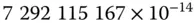 rad/s, or about 15.04109 deg/h. This is its sidereal rotation rate with respect to distant stars. Its mean rotation rate with respect to the nearest star (our Sun), as viewed from the rotating Earth, is 15 deg/h, averaged over one year.
3.4.4 Gravity Models
Because an INS operates in a world with gravitational accelerations it is unable to sense and unable to ignore, it must use a reasonably faithful model of gravity.
Gravity models for the Earth include centrifugal acceleration due to rotation of the Earth as well as true gravitational accelerations due to the mass distribution of the Earth, but they do not generally include oscillatory effects such as tidal variations.
3.4.4.1 Gravitational Potential
Gravitational potential of a unit of mass is defined to be zero at a point infinitely distant from all massive bodies and to decrease toward massive bodies such as the Earth. That is, a point at infinity is the reference point for gravitational potential.
In effect, the gravitational potential at a point in or near the Earth is defined by the potential energy lost per unit of mass falling to that point from infinite altitude. In falling from infinity, potential energy is converted to kinetic energy,  where
where  is the escape velocity . Escape velocity at the surface of the Earth is about 11 km/s.
Интервал:
Закладка:
Похожие книги на «Global Navigation Satellite Systems, Inertial Navigation, and Integration»
Представляем Вашему вниманию похожие книги на «Global Navigation Satellite Systems, Inertial Navigation, and Integration» списком для выбора. Мы отобрали схожую по названию и смыслу литературу в надежде предоставить читателям больше вариантов отыскать новые, интересные, ещё непрочитанные произведения.


Обсуждение, отзывы о книге «Global Navigation Satellite Systems, Inertial Navigation, and Integration» и просто собственные мнения читателей. Оставьте ваши комментарии, напишите, что Вы думаете о произведении, его смысле или главных героях. Укажите что конкретно понравилось, а что нет, и почему Вы так считаете.