Mohinder S. Grewal - Global Navigation Satellite Systems, Inertial Navigation, and Integration
Здесь есть возможность читать онлайн «Mohinder S. Grewal - Global Navigation Satellite Systems, Inertial Navigation, and Integration» — ознакомительный отрывок электронной книги совершенно бесплатно, а после прочтения отрывка купить полную версию. В некоторых случаях можно слушать аудио, скачать через торрент в формате fb2 и присутствует краткое содержание. Жанр: unrecognised, на английском языке. Описание произведения, (предисловие) а так же отзывы посетителей доступны на портале библиотеки ЛибКат.

- Название:Global Navigation Satellite Systems, Inertial Navigation, and Integration
- Автор:
- Жанр:
- Год:неизвестен
- ISBN:нет данных
- Рейтинг книги:4 / 5. Голосов: 1
-
Избранное:Добавить в избранное
- Отзывы:
-
Ваша оценка:
Global Navigation Satellite Systems, Inertial Navigation, and Integration: краткое содержание, описание и аннотация
Предлагаем к чтению аннотацию, описание, краткое содержание или предисловие (зависит от того, что написал сам автор книги «Global Navigation Satellite Systems, Inertial Navigation, and Integration»). Если вы не нашли необходимую информацию о книге — напишите в комментариях, мы постараемся отыскать её.
GNSSs including GPS, Glonass, Galileo, BeiDou, QZSS, and IRNSS/NAViC,
and MATLAB programs on square root information filtering (SRIF)
This book provides readers with solutions to real-world problems associated with global navigation satellite systems, inertial navigation, and integration. It presents readers with numerous detailed examples and practice problems, including GNSS-aided INS, modeling of gyros and accelerometers, and SBAS and GBAS. This revised fourth edition adds new material on GPS III and RAIM. It also provides updated information on low cost sensors such as MEMS, as well as GLONASS, Galileo, BeiDou, QZSS, and IRNSS/NAViC, and QZSS. Revisions also include added material on the more numerically stable square-root information filter (SRIF) with MATLAB programs and examples from GNSS system state filters such as ensemble time filter with square-root covariance filter (SRCF) of Bierman and Thornton and SigmaRho filter.
Global Navigation Satellite Systems, Inertial Navigation, and Integration, 4th Edition Updates on the significant upgrades in existing GNSS systems, and on other systems currently under advanced development Expanded coverage of basic principles of antenna design, and practical antenna design solutions More information on basic principles of receiver design, and an update of the foundations for code and carrier acquisition and tracking within a GNSS receiver Examples demonstrating independence of Kalman filtering from probability density functions of error sources beyond their means and covariances New coverage of inertial navigation to cover recent technology developments and the mathematical models and methods used in its implementation Wider coverage of GNSS/INS integration, including derivation of a unified GNSS/INS integration model, its MATLAB implementations, and performance evaluation under simulated dynamic conditions
is intended for people who need a working knowledge of Global Navigation Satellite Systems (GNSS), Inertial Navigation Systems (INS), and the Kalman filtering models and methods used in their integration.
Global Navigation Satellite Systems, Inertial Navigation, and Integration — читать онлайн ознакомительный отрывок
Ниже представлен текст книги, разбитый по страницам. Система сохранения места последней прочитанной страницы, позволяет с удобством читать онлайн бесплатно книгу «Global Navigation Satellite Systems, Inertial Navigation, and Integration», без необходимости каждый раз заново искать на чём Вы остановились. Поставьте закладку, и сможете в любой момент перейти на страницу, на которой закончили чтение.
Интервал:
Закладка:
Transverse Radius of Curvature
The radius of curvature of the reference ellipsoid surface in the east–west direction (i.e. orthogonal to the direction in which the meridional radius of curvature is measured) is called the transverse radius of curvature . It is the radius of the osculating circle in the local east–up plane, as illustrated in Figure 3.11, where the arrows at the point of tangency of the transverse osculating circle are in the local ENU coordinate directions. As this figure illustrates, on an oblate Earth, the plane of a transverse osculating circle does not pass through the center of the Earth, except when the point of osculation is at the equator. (All osculating circles at the poles are in meridional planes.) Also, unlike meridional osculating circles, transverse osculating circles generally lie outside the ellipsoidal surface, except at the point of tangency and at the equator, where the transverse osculating circle is the equator.
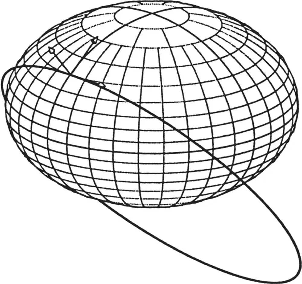
Figure 3.11Transverse osculating circle.
The formula for the transverse radius of curvature on an ellipsoid of revolution is
(3.11) 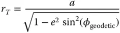
where  is the semimajor axis of the generating ellipse and
  is its eccentricity.
Longitude Rate
The rate of change of longitude as a function of east velocity is then
(3.12) 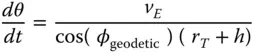
and longitude can be maintained by the integral
(3.13) 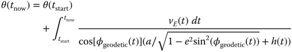
where  is height above (
  ) or below (
  ) the ellipsoid surface and
  will be in radians if
  is in meters per second and
  and
and  are in meters. Note that this formula has a singularity at the poles, where cos(
  , a consequence of using latitude and longitude as location variables.
WGS84 Reference Surface Curvatures
The apparent variations in meridional radius of curvature in Figure 3.10are rather large because the ellipse used in generating Figure 3.10has an eccentricity of about 0.75. The WGS84 ellipse has an eccentricity of about 0.08, with geocentric, meridional, and transverse radius of curvature as plotted in Figure 3.12versus geodetic latitude. For the WGS84 model,
• Mean geocentric radius is about 6371 km, from which it varies by –14.3 km (–0.22%) to +7.1 km (+0.11%).
• Mean meridional radius of curvature is about 6357 km, from which it varies by –21.3 km (–0.33%) to 42.8 km (+0.67%).
• Mean transverse radius of curvature is about 6385 km, from which it varies by –7.1 km (–0.11%) to +14.3 km (+0.22%).
Because these vary by several parts per thousand, one must take radius of curvature into account when integrating horizontal velocity increments to obtain longitude and latitude.
3.4.5 Attitude Models
Attitude models for inertial navigation represent
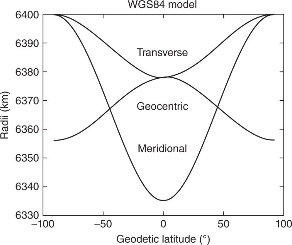
Figure 3.12Radii of WGS84 reference ellipsoid.
1 The relative rotational orientations of two coordinate systems, usually represented by coordinate transformation matrices but also represented in terms of rotation vectors.
2 Attitude dynamics, usually represented in terms of three‐dimensional rotation rate vectors but also represented by four‐dimensional quaternion.
3.4.5.1 Coordinate Transformation Matrices and Rotation Vectors
Appendix B on www.wiley.com/go/grewal/gnssis all about the coordinates, coordinate transformation matrices, and rotation vectors used in inertial navigation.
3.4.5.2 Attitude Dynamics
Rate gyroscopes used in inertial navigation measure components of a rotation rate vector  in ISA‐fixed coordinates, which had historically been used to express its effect on a coordinate transformation matrix
  from ISA coordinates to the coordinates for integration in terms of a linear differential equation of the sort
(3.14) 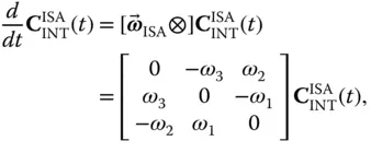
which is not particularly well‐conditioned for numerical integration.
The alternative representation in terms of quaternions is described in Section 3.6.1.2and (in greater detail) in Appendix B.
3.5 Initializing The Navigation Solution
3.5.1 Initialization from an Earth‐fixed Stationary State
3.5.1.1 Accelerometer Recalibration
This is only possible with gimbaled systems and it adds to the start‐up time, but it can improve performance. Navigation accuracy is very sensitive to accelerometer biases, which can shift due to thermal transients in turn‐on/turn‐off cycles, and can also drift randomly over time for some accelerometer design. Fortunately, gimbals can be used to calibrate accelerometer biases in a stationary 1g environment. Bias and scale factors can both be determined by using the gimbals to point each accelerometer input axes straight up and then straight down (by nulling the horizontal accelerometer outputs). Then each accelerometer's bias is the average of the up and down outputs and scale factor is half the difference divided by the local gravitational acceleration.
Читать дальшеИнтервал:
Закладка:
Похожие книги на «Global Navigation Satellite Systems, Inertial Navigation, and Integration»
Представляем Вашему вниманию похожие книги на «Global Navigation Satellite Systems, Inertial Navigation, and Integration» списком для выбора. Мы отобрали схожую по названию и смыслу литературу в надежде предоставить читателям больше вариантов отыскать новые, интересные, ещё непрочитанные произведения.


Обсуждение, отзывы о книге «Global Navigation Satellite Systems, Inertial Navigation, and Integration» и просто собственные мнения читателей. Оставьте ваши комментарии, напишите, что Вы думаете о произведении, его смысле или главных героях. Укажите что конкретно понравилось, а что нет, и почему Вы так считаете.