Mohinder S. Grewal - Global Navigation Satellite Systems, Inertial Navigation, and Integration
Здесь есть возможность читать онлайн «Mohinder S. Grewal - Global Navigation Satellite Systems, Inertial Navigation, and Integration» — ознакомительный отрывок электронной книги совершенно бесплатно, а после прочтения отрывка купить полную версию. В некоторых случаях можно слушать аудио, скачать через торрент в формате fb2 и присутствует краткое содержание. Жанр: unrecognised, на английском языке. Описание произведения, (предисловие) а так же отзывы посетителей доступны на портале библиотеки ЛибКат.
- Название:Global Navigation Satellite Systems, Inertial Navigation, and Integration
- Автор:
- Жанр:
- Год:неизвестен
- ISBN:нет данных
- Рейтинг книги:4 / 5. Голосов: 1
-
Избранное:Добавить в избранное
- Отзывы:
-
Ваша оценка:
Global Navigation Satellite Systems, Inertial Navigation, and Integration: краткое содержание, описание и аннотация
Предлагаем к чтению аннотацию, описание, краткое содержание или предисловие (зависит от того, что написал сам автор книги «Global Navigation Satellite Systems, Inertial Navigation, and Integration»). Если вы не нашли необходимую информацию о книге — напишите в комментариях, мы постараемся отыскать её.
GNSSs including GPS, Glonass, Galileo, BeiDou, QZSS, and IRNSS/NAViC,
and MATLAB programs on square root information filtering (SRIF)
This book provides readers with solutions to real-world problems associated with global navigation satellite systems, inertial navigation, and integration. It presents readers with numerous detailed examples and practice problems, including GNSS-aided INS, modeling of gyros and accelerometers, and SBAS and GBAS. This revised fourth edition adds new material on GPS III and RAIM. It also provides updated information on low cost sensors such as MEMS, as well as GLONASS, Galileo, BeiDou, QZSS, and IRNSS/NAViC, and QZSS. Revisions also include added material on the more numerically stable square-root information filter (SRIF) with MATLAB programs and examples from GNSS system state filters such as ensemble time filter with square-root covariance filter (SRCF) of Bierman and Thornton and SigmaRho filter.
Global Navigation Satellite Systems, Inertial Navigation, and Integration, 4th Edition Updates on the significant upgrades in existing GNSS systems, and on other systems currently under advanced development Expanded coverage of basic principles of antenna design, and practical antenna design solutions More information on basic principles of receiver design, and an update of the foundations for code and carrier acquisition and tracking within a GNSS receiver Examples demonstrating independence of Kalman filtering from probability density functions of error sources beyond their means and covariances New coverage of inertial navigation to cover recent technology developments and the mathematical models and methods used in its implementation Wider coverage of GNSS/INS integration, including derivation of a unified GNSS/INS integration model, its MATLAB implementations, and performance evaluation under simulated dynamic conditions
is intended for people who need a working knowledge of Global Navigation Satellite Systems (GNSS), Inertial Navigation Systems (INS), and the Kalman filtering models and methods used in their integration.
Global Navigation Satellite Systems, Inertial Navigation, and Integration — читать онлайн ознакомительный отрывок
Ниже представлен текст книги, разбитый по страницам. Система сохранения места последней прочитанной страницы, позволяет с удобством читать онлайн бесплатно книгу «Global Navigation Satellite Systems, Inertial Navigation, and Integration», без необходимости каждый раз заново искать на чём Вы остановились. Поставьте закладку, и сможете в любой момент перейти на страницу, на которой закончили чтение.
Интервал:
Закладка:
3.5.1.2 Initializing Position and Velocity
Velocity . Zero, by definition.
Position . From GNSS, if available, otherwise from local sources – e.g. signs or local auxiliary sensors (see Section 3.5.1.3).
3.5.1.3 Initializing ISA Attitude
Gyrocompassing . Gyrocompass alignment of stationary vehicles uses the sensed direction of acceleration to determine the local vertical and the sensed direction of rotation to determine north, as illustrated in Figure 3.13.
Using auxiliary sensors . Non‐gyroscopic attitude sensors can also be used as aids in alignment. These include the following:

Figure 3.13Gyrocompassing determines sensor orientations with respect to east, north, and up.
Magnetic sensors are used primarily for coarse heading alignment, to speed up INS alignment.
Star trackers are used primarily for space‐based or near‐space applications. The Snark cruise missile and the U‐2 spy plane used inertial‐platform‐mounted star trackers to maintain INS alignment on long flights, an idea attributed to Northrop Aviation.
Optical alignment systems have been used on some systems prior to launch. Some use Porro prisms mounted on the inertial platform to maintain optical line‐of‐sight reference through ground‐based theodolites to reference directions at the launch complex.
Quasi magnetostatic sensors have been used in virtual reality systems for determining the attitude and position of the headset relative to its environment. These use three orthogonal and independently coded low‐to‐medium frequency magnetic dipole sources to illuminate the local area where rotational and locational orientation data is required, and three‐axis AC magnetic sensors as receivers.
3.5.1.4 Gyrocompass Alignment Accuracy
Gyrocompass alignment is not necessary for integrated GNSS/INS navigation, although many INSs may already be configured for it.
Accuracy
A rough rule‐of‐thumb for gyrocompass alignment accuracy is
(3.15) 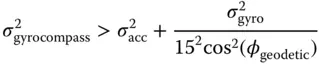
where
is the minimum achievable root‐mean‐square (RMS) alignment error in radians,
is the RMS accelerometer accuracy in 's,
is the RMS gyroscope accuracy in degrees per hour,
15 deg/h is the rotation rate of the Earth, and
is the latitude at which gyrocompassing is performed.
Alignment accuracy is also a function of the time allotted for it, and the time required to achieve a specified accuracy is generally a function of sensor error magnitudes (including noise) and the degree to which the vehicle remains stationary.
Gimbaled implementation . Gyrocompass alignment for gimbaled systems is a process for aligning the inertial platform axes with the navigation coordinates using only the sensor outputs while the host vehicle is essentially stationary. For systems using ENU navigation coordinates, for example, the platform can be tilted until two of its accelerometer inputs are zero, at which time both input axes will be horizontal. In this locally leveled orientation, the sensed rotation axis will be in the north–up plane, and the platform can be slewed about the vertical axis to null the input of one of its horizontal gyroscopes, at which time that gyroscope input axis will point east–west. That is the basic concept used for gyrocompass alignment, but practical implementation requires filtering 5 to reduce the effects of sensor noise and unpredictable zero‐mean vehicle disturbances due to loading activities and/or wind gusts.
Strapdown implementation . Gyrocompass alignment for strapdown systems is a process for “virtual alignment” by determining the sensor cluster attitude with respect to navigation coordinates using only the sensor outputs while the system is essentially stationary.
Error‐free implementation . If the sensor cluster could be firmly affixed to the Earth and there were no sensor errors, then the sensed acceleration vector  in sensor coordinates would be in the direction of the local vertical, the sensed rotation vector
  would be in the direction of the Earth rotation axis, and the unit column vectors
(3.16) 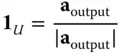
(3.17) 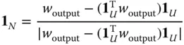
(3.18) 
would define the initial value of the coordinate transformation matrix from sensor‐fixed coordinates to ENU coordinates:
(3.19) 
Practical implementation . In practice, the sensor cluster is usually mounted in a vehicle that is not moving over the surface of the Earth, but may be buffeted by wind gusts or disturbed during fueling and loading operations. Gyrocompassing then requires some amount of filtering (Kalman filtering, as a rule) to reduce the effects of vehicle buffeting and sensor noise. The gyrocompass filtering period is typically on the order of several minutes for a medium‐accuracy INS but may continue for hours, days, or continuously for high‐accuracy systems.
3.5.2 Initialization on the Move
3.5.2.1 Transfer Alignment
This method is generally faster than gyrocompass alignment, but it requires another INS on the host vehicle and it may require special maneuvering of the host vehicle to attain observability of the alignment variables. It is commonly used for in‐air INS alignment for missiles launched from aircraft and for on‐deck INS alignment for aircraft launched from carriers. Alignment of carrier‐launched aircraft may also use the direction of the velocity impulse imparted by the steam catapult.
3.5.2.2 Initializing Using GNSS
This is an issue in GNSS/INS integration, which is covered in Chapter 12. In this case it must also estimate the INS orientation and velocity, the observability of which generally depends on the host vehicle trajectory.
3.6 Propagating The Navigation Solution
3.6.1 Attitude Propagation
Knowing the instantaneous rotational orientations of the inertial sensor input axes with respect to navigational coordinates is essential for inertial navigation to work. The integration of accelerations for maintaining the navigation solution for velocity and position depends on it.
Читать дальшеИнтервал:
Закладка:
Похожие книги на «Global Navigation Satellite Systems, Inertial Navigation, and Integration»
Представляем Вашему вниманию похожие книги на «Global Navigation Satellite Systems, Inertial Navigation, and Integration» списком для выбора. Мы отобрали схожую по названию и смыслу литературу в надежде предоставить читателям больше вариантов отыскать новые, интересные, ещё непрочитанные произведения.


Обсуждение, отзывы о книге «Global Navigation Satellite Systems, Inertial Navigation, and Integration» и просто собственные мнения читателей. Оставьте ваши комментарии, напишите, что Вы думаете о произведении, его смысле или главных героях. Укажите что конкретно понравилось, а что нет, и почему Вы так считаете.