Mohinder S. Grewal - Global Navigation Satellite Systems, Inertial Navigation, and Integration
Здесь есть возможность читать онлайн «Mohinder S. Grewal - Global Navigation Satellite Systems, Inertial Navigation, and Integration» — ознакомительный отрывок электронной книги совершенно бесплатно, а после прочтения отрывка купить полную версию. В некоторых случаях можно слушать аудио, скачать через торрент в формате fb2 и присутствует краткое содержание. Жанр: unrecognised, на английском языке. Описание произведения, (предисловие) а так же отзывы посетителей доступны на портале библиотеки ЛибКат.
- Название:Global Navigation Satellite Systems, Inertial Navigation, and Integration
- Автор:
- Жанр:
- Год:неизвестен
- ISBN:нет данных
- Рейтинг книги:4 / 5. Голосов: 1
-
Избранное:Добавить в избранное
- Отзывы:
-
Ваша оценка:
Global Navigation Satellite Systems, Inertial Navigation, and Integration: краткое содержание, описание и аннотация
Предлагаем к чтению аннотацию, описание, краткое содержание или предисловие (зависит от того, что написал сам автор книги «Global Navigation Satellite Systems, Inertial Navigation, and Integration»). Если вы не нашли необходимую информацию о книге — напишите в комментариях, мы постараемся отыскать её.
GNSSs including GPS, Glonass, Galileo, BeiDou, QZSS, and IRNSS/NAViC,
and MATLAB programs on square root information filtering (SRIF)
This book provides readers with solutions to real-world problems associated with global navigation satellite systems, inertial navigation, and integration. It presents readers with numerous detailed examples and practice problems, including GNSS-aided INS, modeling of gyros and accelerometers, and SBAS and GBAS. This revised fourth edition adds new material on GPS III and RAIM. It also provides updated information on low cost sensors such as MEMS, as well as GLONASS, Galileo, BeiDou, QZSS, and IRNSS/NAViC, and QZSS. Revisions also include added material on the more numerically stable square-root information filter (SRIF) with MATLAB programs and examples from GNSS system state filters such as ensemble time filter with square-root covariance filter (SRCF) of Bierman and Thornton and SigmaRho filter.
Global Navigation Satellite Systems, Inertial Navigation, and Integration, 4th Edition Updates on the significant upgrades in existing GNSS systems, and on other systems currently under advanced development Expanded coverage of basic principles of antenna design, and practical antenna design solutions More information on basic principles of receiver design, and an update of the foundations for code and carrier acquisition and tracking within a GNSS receiver Examples demonstrating independence of Kalman filtering from probability density functions of error sources beyond their means and covariances New coverage of inertial navigation to cover recent technology developments and the mathematical models and methods used in its implementation Wider coverage of GNSS/INS integration, including derivation of a unified GNSS/INS integration model, its MATLAB implementations, and performance evaluation under simulated dynamic conditions
is intended for people who need a working knowledge of Global Navigation Satellite Systems (GNSS), Inertial Navigation Systems (INS), and the Kalman filtering models and methods used in their integration.
Global Navigation Satellite Systems, Inertial Navigation, and Integration — читать онлайн ознакомительный отрывок
Ниже представлен текст книги, разбитый по страницам. Система сохранения места последней прочитанной страницы, позволяет с удобством читать онлайн бесплатно книгу «Global Navigation Satellite Systems, Inertial Navigation, and Integration», без необходимости каждый раз заново искать на чём Вы остановились. Поставьте закладку, и сможете в любой момент перейти на страницу, на которой закончили чтение.
Интервал:
Закладка:
3.6.1.5 Gimbal Attitude Implementations
The primary function of gimbals is to isolate the ISA from vehicle rotations, but they are also used for other INS functions.
Vehicle Attitude Determination
The gimbal angles determine the vehicle attitude with respect to the ISA, which has a controlled orientation with respect to navigation coordinates. Each gimbal angle encoder output determines the relative rotation of the structure outside gimbal axis relative to the structure inside the gimbal axis, the effect of each rotation can be represented by a  rotation matrix, and the coordinate transformation matrix representing the attitude of vehicle with respect to the ISA will be the ordered product of these matrices.
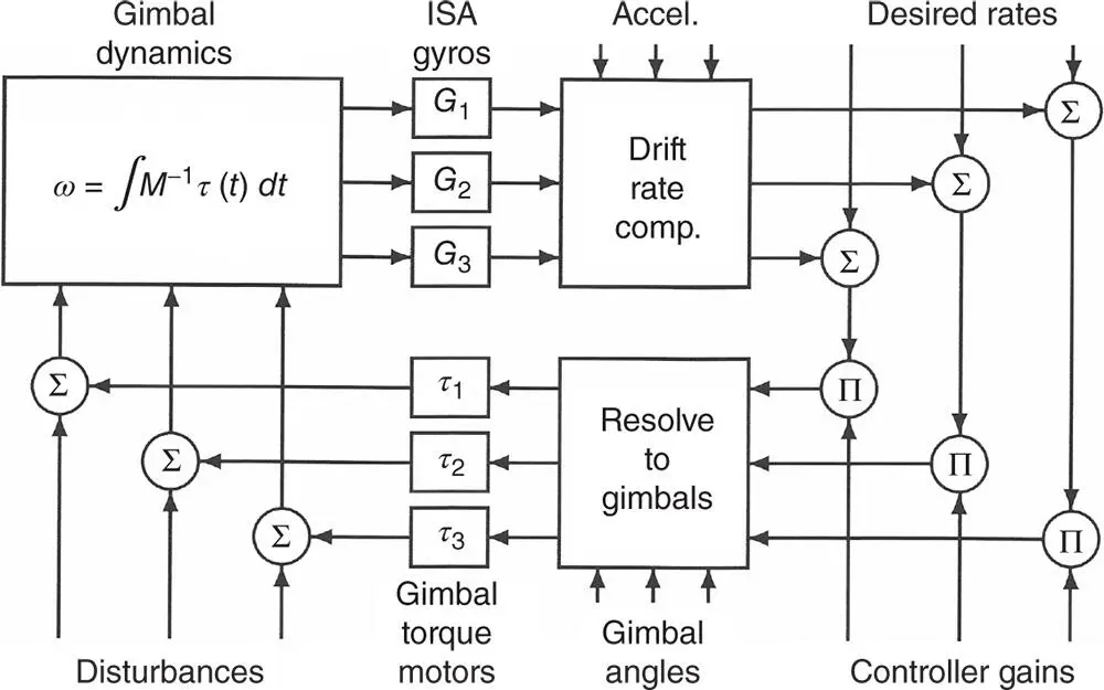
Figure 3.20Simplified control flow diagram for three gimbals.
ISA Attitude Control
Gimbals control ISA orientation. This is a three‐degree‐of‐freedom problem, and the solution is unique for three gimbals. That is, there are three attitude‐control loops with (at least) three sensors (the gyroscopes) and three torquers. Each control loop can use a PID controller, with the commanded torque distributed to the three torquers according to the direction of the torquer/gimbal axis with respect to the gyro input axis, somewhat as illustrated in Figure 3.20, where
Disturbances includes the sum of all torque disturbances on the individual gimbals and the ISA, including those due to ISA mass unbalance and acceleration, rotations of the host vehicle, air currents, torque motor errors, etc.
Gimbal dynamics is actually quite a bit more complicated than the rigid‐body torque equation
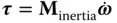
which is the torque analog of  , where
  is the moment of inertia matrix. The IMU is not a rigid body, and the gimbal torque motors apply torques between the gimbal elements (i.e. ISA, gimbal rings, and host vehicle).
Desired rates refers to the rates required to keep the ISA aligned to a moving coordinate frame (e.g. locally level).
Resolve to gimbals is where the required torques are apportioned among the individual torquer motors on the gimbal axes.
The actual control loop is more complicated than that shown in the figure, but it does illustrate in general terms how the sensors and actuators are used.
For systems using four gimbals to avoid gimbal lock, the added gimbal adds another degree of freedom to be controlled. In this case, the control law usually adds a fourth constraint (e.g. maximize the minimum angle between gimbal axes) to avoid gimbal lock.
3.6.2 Position and Velocity Propagation
3.6.2.1 Vertical Channel Instability
The INS navigation solution for altitude and altitude rate is called its vertical channel . It might have become the Achilles heel of inertial navigation if it had not been recognized (by physicist George Gamow [10]) and resolved (by Charles Stark Draper and others) early on.
The reason for this is that the vertical gradient of the gravitational acceleration is negative. Because accelerometers cannot sense gravitational accelerations, the INS must rely on Newton's universal law of gravitation to take them into account in the navigation solution. Newton's law has the downward gravitational acceleration inversely proportional to the square of the radius from the Earth's center, which then falls off with increasing altitude. Therefore an INS resting stationary on the surface of the Earth with an upward navigational error in altitude would compute a downward gravitational acceleration smaller that the (measured) upward specific force countering gravity, which would result in an upward navigational acceleration error, which only makes matters worse. This would not be a problem for surface ships, it might have been a problem for aircraft if they did not already use barometric altimeters, and similarly for submarines if they did not already use depth sensors. It became an early example of sensor integration successfully applied to inertial navigation.
This is no longer a serious issue, now that we have chip‐scale barometric altimeters.
3.6.2.2 Strapdown Navigation Propagation
The basic signal processing functions for strapdown INS navigation are illustrated in Figure 3.21, where
G is the estimated gravitational acceleration, computed as a function of estimated position.
is the estimated position of the host vehicle in navigation coordinates.
is the estimated velocity of the host vehicle in navigation coordinates.
is the estimated acceleration of the host vehicle in navigation coordinates, which may be used for trajectory control (i.e. vehicle guidance).
is the estimated acceleration of the host vehicle in sensor‐fixed coordinates, which may be used for vehicle steering stabilization and control.
is the coordinate transformation matrix from sensor‐fixed coordinates to navigation coordinates, representing the attitude of the sensors in navigation coordinates.
is the estimated angular velocity of the host vehicle in sensor‐fixed (ISA) coordinates, which may be used for vehicle attitude stabilization and control.
is the estimated angular velocity of the host vehicle in navigation coordinates, which may be used in a vehicle pointing and attitude control loop.
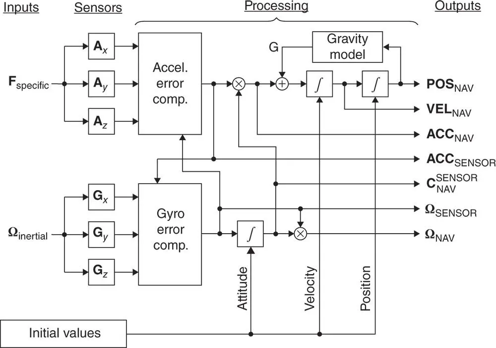
Figure 3.21Essential navigation signal processing for strapdown INS.
The essential processing functions include double integration (represented by boxes containing integration symbols) of acceleration to obtain position, and computation of (unsensed) gravitational acceleration as a function of position. The sensed angular rates also need to be integrated to maintain the knowledge of sensor attitudes. The initial values of all the integrals (i.e. position, velocity, and attitude) must also be known before integration can begin.
The position vector  is the essential navigation solution. The other outputs shown are not needed for all applications, but most of them (except
  ) are intermediate results that are available “for free” (i.e. without requiring further processing). The velocity vector
  , for example, characterizes speed and heading, which are also useful for correcting the course of the host vehicle to bring it to a desired location. Most of the other outputs shown would be required for implementing control of an unmanned or autonomous host vehicle to follow a desired trajectory and/or to bring the host vehicle to a desired final position.
Интервал:
Закладка:
Похожие книги на «Global Navigation Satellite Systems, Inertial Navigation, and Integration»
Представляем Вашему вниманию похожие книги на «Global Navigation Satellite Systems, Inertial Navigation, and Integration» списком для выбора. Мы отобрали схожую по названию и смыслу литературу в надежде предоставить читателям больше вариантов отыскать новые, интересные, ещё непрочитанные произведения.


Обсуждение, отзывы о книге «Global Navigation Satellite Systems, Inertial Navigation, and Integration» и просто собственные мнения читателей. Оставьте ваши комментарии, напишите, что Вы думаете о произведении, его смысле или главных героях. Укажите что конкретно понравилось, а что нет, и почему Вы так считаете.