Mohinder S. Grewal - Global Navigation Satellite Systems, Inertial Navigation, and Integration
Здесь есть возможность читать онлайн «Mohinder S. Grewal - Global Navigation Satellite Systems, Inertial Navigation, and Integration» — ознакомительный отрывок электронной книги совершенно бесплатно, а после прочтения отрывка купить полную версию. В некоторых случаях можно слушать аудио, скачать через торрент в формате fb2 и присутствует краткое содержание. Жанр: unrecognised, на английском языке. Описание произведения, (предисловие) а так же отзывы посетителей доступны на портале библиотеки ЛибКат.
- Название:Global Navigation Satellite Systems, Inertial Navigation, and Integration
- Автор:
- Жанр:
- Год:неизвестен
- ISBN:нет данных
- Рейтинг книги:4 / 5. Голосов: 1
-
Избранное:Добавить в избранное
- Отзывы:
-
Ваша оценка:
Global Navigation Satellite Systems, Inertial Navigation, and Integration: краткое содержание, описание и аннотация
Предлагаем к чтению аннотацию, описание, краткое содержание или предисловие (зависит от того, что написал сам автор книги «Global Navigation Satellite Systems, Inertial Navigation, and Integration»). Если вы не нашли необходимую информацию о книге — напишите в комментариях, мы постараемся отыскать её.
GNSSs including GPS, Glonass, Galileo, BeiDou, QZSS, and IRNSS/NAViC,
and MATLAB programs on square root information filtering (SRIF)
This book provides readers with solutions to real-world problems associated with global navigation satellite systems, inertial navigation, and integration. It presents readers with numerous detailed examples and practice problems, including GNSS-aided INS, modeling of gyros and accelerometers, and SBAS and GBAS. This revised fourth edition adds new material on GPS III and RAIM. It also provides updated information on low cost sensors such as MEMS, as well as GLONASS, Galileo, BeiDou, QZSS, and IRNSS/NAViC, and QZSS. Revisions also include added material on the more numerically stable square-root information filter (SRIF) with MATLAB programs and examples from GNSS system state filters such as ensemble time filter with square-root covariance filter (SRCF) of Bierman and Thornton and SigmaRho filter.
Global Navigation Satellite Systems, Inertial Navigation, and Integration, 4th Edition Updates on the significant upgrades in existing GNSS systems, and on other systems currently under advanced development Expanded coverage of basic principles of antenna design, and practical antenna design solutions More information on basic principles of receiver design, and an update of the foundations for code and carrier acquisition and tracking within a GNSS receiver Examples demonstrating independence of Kalman filtering from probability density functions of error sources beyond their means and covariances New coverage of inertial navigation to cover recent technology developments and the mathematical models and methods used in its implementation Wider coverage of GNSS/INS integration, including derivation of a unified GNSS/INS integration model, its MATLAB implementations, and performance evaluation under simulated dynamic conditions
is intended for people who need a working knowledge of Global Navigation Satellite Systems (GNSS), Inertial Navigation Systems (INS), and the Kalman filtering models and methods used in their integration.
Global Navigation Satellite Systems, Inertial Navigation, and Integration — читать онлайн ознакомительный отрывок
Ниже представлен текст книги, разбитый по страницам. Система сохранения места последней прочитанной страницы, позволяет с удобством читать онлайн бесплатно книгу «Global Navigation Satellite Systems, Inertial Navigation, and Integration», без необходимости каждый раз заново искать на чём Вы остановились. Поставьте закладку, и сможете в любой момент перейти на страницу, на которой закончили чтение.
Интервал:
Закладка:
(2.39) 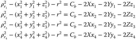
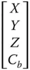
with unknown 4 × 1 state vector
We can rewrite the four equations in matrix form as
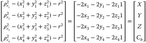
or
(2.40) 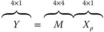
where
| Y | = | vector (known) |
| M | = | matrix (known) |
| X ρ | = | vector (unknown) |
Then, we premultiply both sides of Eq. (2.40)by M −1:
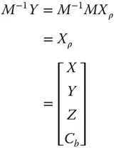
If the rank of M , the number of linear independent columns of the matrix M , is less than 4, then M will not be invertible.
2.5.2 User Velocity Calculations
Differentiate Eq. (2.21)with respect to time without C b.
(2.41) 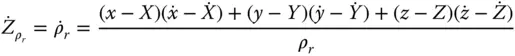
Differentiate Eq. (2.41)with respect to 
(2.42) 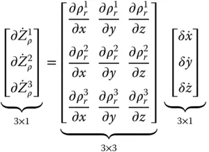
where  .
.
In classical navigation geometry, the components (3 × 3) of this unit vector are often called direction cosine. It is interesting to note that these components are the same as the position linearization shown in Eqs. (2.26a)and (2.26b).
Equations (2.42)and (2.26b)will be used in GPS/INS tightly coupled implementation as measurement equations for pseudoranges and/or delta pseudoranges in chapters 11 and 12 in the extended Kalman filters. Equation (2.27)will be used in integrity determination of GNSS satellites in Chapter 9 and from Eq. (2.41),
(2.43) 
where
 |
= | range rate (known) |
| ρ r | = | range (known) |
| ( x, y, z ) | = | satellite positions (known) |
(  , ,  , ,  ) ) |
= | satellite rates (known) |
| X , Y , Z | = | user position (known from position calculations) |
(  , ,  , ,  ) ) |
= | user velocity (unknown) |
For three satellites, Eq. (2.43)becomes
(2.44) 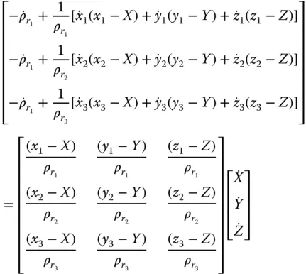
Equation (2.44)becomes
(2.45) 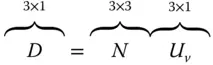
(2.46) 
where
| D | = | known vector |
| N | = | known matrix |
| U v | = | unknown user velocity vector |
However, if the rank of N is <3, N will not be invertible.
Problems
Refer to Appendix B for coordinate system definitions and to Section B.3.10 for satellite orbit equations.
1 2.1 Which of the following coordinate systems is not rotating?North–east–down (NED)East–north–up (ENU)Earth‐centered, Earth‐fixed (ECEF)Earth‐centered inertial (ECI)Moon‐centered, moon fixed
2 2.2 Show that the 3 × 3 identity matrix. (Hint: ).
3 2.3 Rank VDOP, HDOP, and PDOP from smallest (best) to largest (worst) under normal conditions:VDOP ≤ HDOP ≤ PDOPVDOP ≤ PDOP ≤ HDOPHDOP ≤ VDOP≤PDOPHDOP ≤ PDOP ≤ VDOPPDOP ≤ HDOP ≤ VDOPPDOP ≤ VDOP ≤ HDOP
4 2.4 UTC time and the GPS time are offset by an integer number of seconds (e.g. 16 seconds as of June 2012) as well as a fraction of a second. The fractional part is approximately.0.1–0.5 s1–2 ms100–200 ns10–20 ns
5 2.5 Derive equations (2.41)and (2.42).
6 2.6 For the following GPS satellites, find the satellite position in ECEF coordinates at t = 3 seconds. (Hint: See Appendix B.) Ω0 and θ0 are given below at time t0 = 0:Ω0 (°)θ0 (°)(a)32668(b)2634
7 2.7 Using the results of the previous problem, find the satellite positions in the local reference frame. Reference should be to the COMSAT facility in Santa Paula, California, located at 32.4° latitude, −119.2° longitude. Use coordinate shift matrix S = 0. (Refer to Section B.3.10.)
8 2.8 Given the following GPS satellite coordinates and pseudoranges:SatelliteΩ0 (°)θ0 (°)ρ (m)1326682.324 × 1072263402.0755 × 10731461982.1103 × 1074862712.3491 × 107Find the user's antenna position in ECEF coordinates.Find the user's antenna position in locally level coordinates referenced to 0° latitude, 0° longitude. Coordinate shift matrix S = 0.Find the various DOPs.
9 2.9 Given two satellites in north and east coordinateswith pseudorangesand starting with an initial guess of xest, yest, find the user's antenna position.
10 2.10 A satellite position at time t = 0 is specified by its orbital parameters as Ω0 = 92.847°, θ0 = 135.226°, α = 55°, R = 26 560 000 m.Find the satellite position at one second, in ECEF coordinates.Convert the satellite position from (a) with user atfrom WGS84 (ECEF) to ENU coordinates with origin at
Читать дальшеИнтервал:
Закладка:
Похожие книги на «Global Navigation Satellite Systems, Inertial Navigation, and Integration»
Представляем Вашему вниманию похожие книги на «Global Navigation Satellite Systems, Inertial Navigation, and Integration» списком для выбора. Мы отобрали схожую по названию и смыслу литературу в надежде предоставить читателям больше вариантов отыскать новые, интересные, ещё непрочитанные произведения.


Обсуждение, отзывы о книге «Global Navigation Satellite Systems, Inertial Navigation, and Integration» и просто собственные мнения читателей. Оставьте ваши комментарии, напишите, что Вы думаете о произведении, его смысле или главных героях. Укажите что конкретно понравилось, а что нет, и почему Вы так считаете.