Mohinder S. Grewal - Global Navigation Satellite Systems, Inertial Navigation, and Integration
Здесь есть возможность читать онлайн «Mohinder S. Grewal - Global Navigation Satellite Systems, Inertial Navigation, and Integration» — ознакомительный отрывок электронной книги совершенно бесплатно, а после прочтения отрывка купить полную версию. В некоторых случаях можно слушать аудио, скачать через торрент в формате fb2 и присутствует краткое содержание. Жанр: unrecognised, на английском языке. Описание произведения, (предисловие) а так же отзывы посетителей доступны на портале библиотеки ЛибКат.

- Название:Global Navigation Satellite Systems, Inertial Navigation, and Integration
- Автор:
- Жанр:
- Год:неизвестен
- ISBN:нет данных
- Рейтинг книги:4 / 5. Голосов: 1
-
Избранное:Добавить в избранное
- Отзывы:
-
Ваша оценка:
Global Navigation Satellite Systems, Inertial Navigation, and Integration: краткое содержание, описание и аннотация
Предлагаем к чтению аннотацию, описание, краткое содержание или предисловие (зависит от того, что написал сам автор книги «Global Navigation Satellite Systems, Inertial Navigation, and Integration»). Если вы не нашли необходимую информацию о книге — напишите в комментариях, мы постараемся отыскать её.
GNSSs including GPS, Glonass, Galileo, BeiDou, QZSS, and IRNSS/NAViC,
and MATLAB programs on square root information filtering (SRIF)
This book provides readers with solutions to real-world problems associated with global navigation satellite systems, inertial navigation, and integration. It presents readers with numerous detailed examples and practice problems, including GNSS-aided INS, modeling of gyros and accelerometers, and SBAS and GBAS. This revised fourth edition adds new material on GPS III and RAIM. It also provides updated information on low cost sensors such as MEMS, as well as GLONASS, Galileo, BeiDou, QZSS, and IRNSS/NAViC, and QZSS. Revisions also include added material on the more numerically stable square-root information filter (SRIF) with MATLAB programs and examples from GNSS system state filters such as ensemble time filter with square-root covariance filter (SRCF) of Bierman and Thornton and SigmaRho filter.
Global Navigation Satellite Systems, Inertial Navigation, and Integration, 4th Edition Updates on the significant upgrades in existing GNSS systems, and on other systems currently under advanced development Expanded coverage of basic principles of antenna design, and practical antenna design solutions More information on basic principles of receiver design, and an update of the foundations for code and carrier acquisition and tracking within a GNSS receiver Examples demonstrating independence of Kalman filtering from probability density functions of error sources beyond their means and covariances New coverage of inertial navigation to cover recent technology developments and the mathematical models and methods used in its implementation Wider coverage of GNSS/INS integration, including derivation of a unified GNSS/INS integration model, its MATLAB implementations, and performance evaluation under simulated dynamic conditions
is intended for people who need a working knowledge of Global Navigation Satellite Systems (GNSS), Inertial Navigation Systems (INS), and the Kalman filtering models and methods used in their integration.
Global Navigation Satellite Systems, Inertial Navigation, and Integration — читать онлайн ознакомительный отрывок
Ниже представлен текст книги, разбитый по страницам. Система сохранения места последней прочитанной страницы, позволяет с удобством читать онлайн бесплатно книгу «Global Navigation Satellite Systems, Inertial Navigation, and Integration», без необходимости каждый раз заново искать на чём Вы остановились. Поставьте закладку, и сможете в любой момент перейти на страницу, на которой закончили чтение.
Интервал:
Закладка:
The DOP can be interpreted as the dilution of the precision from the measurement (i.e. range) domain to the solution (i.e. PVT) domain.
The observation measurement equations in three dimensions for each satellite with known coordinates ( x i, y i, z i) and unknown user coordinates ( X , Y , Z ) are given by
(2.21) 
where  is the pseudorange to the i th satellite and C bis the residual satellite clock bias and receiver clock bias, where an estimate of the satellite clock error from the GNSS ground control segment has been removed from C b.
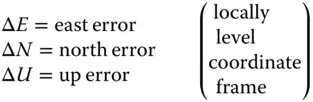
These are nonlinear equations that can be linearized using the Taylor series (see, e.g., chapter 5 of Ref. [4]). The satellite positions may be converted to east–north–up (ENU) from Earth‐centered, Earth‐fixed (ECEF) coordinates (see Appendix B).
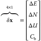
Let the vector of ranges be Z ρ= h( x), a nonlinear function h( x) of the four‐dimensional vector xrepresenting user solution for position and receiver clock bias and expand the left‐hand side of this equation in a Taylor series about some nominal solution x nomfor the unknown vector
(2.22) 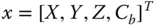
of variables,
| X | = | east component of the user's antenna location (m) |
| Y | = | north component of the user's antenna location (m) |
| Z | = | upward vertical component of the user's antenna location (m) |
| C b | = | receiver clock bias (m) |
for which
(2.23) 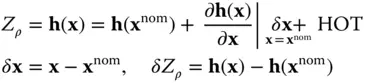
where HOT stands for “higher‐order terms.”
These equations become
(2.24) 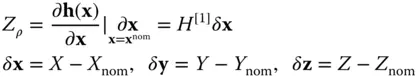
where H [1]is the first‐order term in the Taylor series expansion:
(2.25) 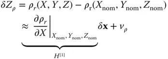
for v ρis the noise in receiver measurements. This vector equation can be written in scalar form where i is the satellite number as
(2.26a) 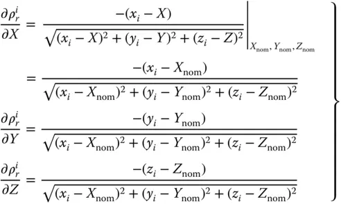
for i = 1, 2, 3, 4 (i.e. four satellites).
We can combine Eqs. (2.25)and (2.26a)into the matrix equation with measurements as
(2.26b) 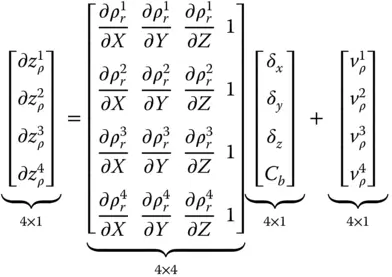
which we can write in symbolic form as
(2.27) 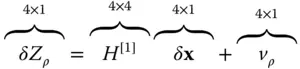
(see table 5.3 in Ref. [4]).
To calculate H [1], one needs satellite positions and the nominal value of the user's position in ENU coordinate frames.
To calculate the geometric dilution of precision (GDOP) (approximately), we obtain
(2.28) 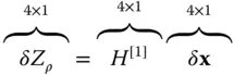
Known are δZ ρand H [1]from the pseudorange, satellite position, and nominal value of the user's position. The correction δ xis the unknown vector.
If we premultiply both sides of Eq. (2.28)by H [1]T, the result will be
(2.29) 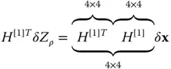
Then, we premultiply Eq. (2.29)by ( H [1]T H [1]) −1:
(2.30) 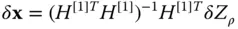
If δ xand δZ ρare assumed random with zero mean, the error covariance ( E = expected value)
(2.31) 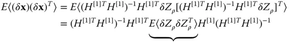
The pseudorange measurement covariance is assumed uncorrelated satellite to satellite with variance σ 2:
(2.32) 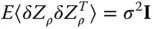
Substituting Eq. (2.32)into Eq. (2.31)gives
(2.33) 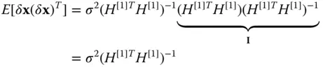
for
and
and the covariance matrix becomes
(2.34) 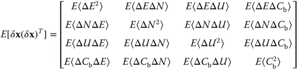
We are principally interested in the diagonal elements of
(2.35) 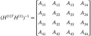
that represent the DOP of range measurement error to the user solution error (see Figure 2.4):
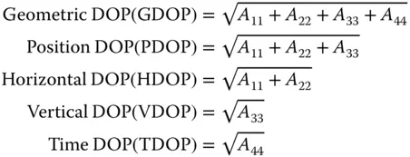
Hence, all DOPs represent the sensitivities of user solution error to pseudorange errors. Figure 2.4illustrates the relationship between the various DOP terms.
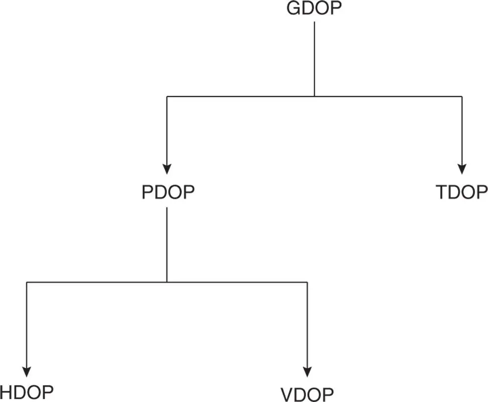
Figure 2.4DOP hierarchy.
2.3.4 Example Calculation of DOPs
Интервал:
Закладка:
Похожие книги на «Global Navigation Satellite Systems, Inertial Navigation, and Integration»
Представляем Вашему вниманию похожие книги на «Global Navigation Satellite Systems, Inertial Navigation, and Integration» списком для выбора. Мы отобрали схожую по названию и смыслу литературу в надежде предоставить читателям больше вариантов отыскать новые, интересные, ещё непрочитанные произведения.


Обсуждение, отзывы о книге «Global Navigation Satellite Systems, Inertial Navigation, and Integration» и просто собственные мнения читателей. Оставьте ваши комментарии, напишите, что Вы думаете о произведении, его смысле или главных героях. Укажите что конкретно понравилось, а что нет, и почему Вы так считаете.