Mohinder S. Grewal - Global Navigation Satellite Systems, Inertial Navigation, and Integration
Здесь есть возможность читать онлайн «Mohinder S. Grewal - Global Navigation Satellite Systems, Inertial Navigation, and Integration» — ознакомительный отрывок электронной книги совершенно бесплатно, а после прочтения отрывка купить полную версию. В некоторых случаях можно слушать аудио, скачать через торрент в формате fb2 и присутствует краткое содержание. Жанр: unrecognised, на английском языке. Описание произведения, (предисловие) а так же отзывы посетителей доступны на портале библиотеки ЛибКат.
- Название:Global Navigation Satellite Systems, Inertial Navigation, and Integration
- Автор:
- Жанр:
- Год:неизвестен
- ISBN:нет данных
- Рейтинг книги:4 / 5. Голосов: 1
-
Избранное:Добавить в избранное
- Отзывы:
-
Ваша оценка:
Global Navigation Satellite Systems, Inertial Navigation, and Integration: краткое содержание, описание и аннотация
Предлагаем к чтению аннотацию, описание, краткое содержание или предисловие (зависит от того, что написал сам автор книги «Global Navigation Satellite Systems, Inertial Navigation, and Integration»). Если вы не нашли необходимую информацию о книге — напишите в комментариях, мы постараемся отыскать её.
GNSSs including GPS, Glonass, Galileo, BeiDou, QZSS, and IRNSS/NAViC,
and MATLAB programs on square root information filtering (SRIF)
This book provides readers with solutions to real-world problems associated with global navigation satellite systems, inertial navigation, and integration. It presents readers with numerous detailed examples and practice problems, including GNSS-aided INS, modeling of gyros and accelerometers, and SBAS and GBAS. This revised fourth edition adds new material on GPS III and RAIM. It also provides updated information on low cost sensors such as MEMS, as well as GLONASS, Galileo, BeiDou, QZSS, and IRNSS/NAViC, and QZSS. Revisions also include added material on the more numerically stable square-root information filter (SRIF) with MATLAB programs and examples from GNSS system state filters such as ensemble time filter with square-root covariance filter (SRCF) of Bierman and Thornton and SigmaRho filter.
Global Navigation Satellite Systems, Inertial Navigation, and Integration, 4th Edition Updates on the significant upgrades in existing GNSS systems, and on other systems currently under advanced development Expanded coverage of basic principles of antenna design, and practical antenna design solutions More information on basic principles of receiver design, and an update of the foundations for code and carrier acquisition and tracking within a GNSS receiver Examples demonstrating independence of Kalman filtering from probability density functions of error sources beyond their means and covariances New coverage of inertial navigation to cover recent technology developments and the mathematical models and methods used in its implementation Wider coverage of GNSS/INS integration, including derivation of a unified GNSS/INS integration model, its MATLAB implementations, and performance evaluation under simulated dynamic conditions
is intended for people who need a working knowledge of Global Navigation Satellite Systems (GNSS), Inertial Navigation Systems (INS), and the Kalman filtering models and methods used in their integration.
Global Navigation Satellite Systems, Inertial Navigation, and Integration — читать онлайн ознакомительный отрывок
Ниже представлен текст книги, разбитый по страницам. Система сохранения места последней прочитанной страницы, позволяет с удобством читать онлайн бесплатно книгу «Global Navigation Satellite Systems, Inertial Navigation, and Integration», без необходимости каждый раз заново искать на чём Вы остановились. Поставьте закладку, и сможете в любой момент перейти на страницу, на которой закончили чтение.
Интервал:
Закладка:
In this case, the receiver and two transmitters are located in the same plane, as shown in Figure 2.3, with known positions of the two transmitters: x 1, y 1and x 2, y 2. Ranges R 1and R 2from the two transmitters to the user position are calculated as
(2.1) 
(2.2) 
where
| c | = | speed of light (0.299 792 458 m/ns) |
| Δ T 1 | = | time taken for the radiowave to travel from transmitter 1 to the user (ns) |
| Δ T 2 | = | time taken for the radiowave to travel from transmitter 2 to the user (ns) |
| X , Y | = | unknown user position to be solved for (m) |
The range to each transmitter can be written as
(2.3) 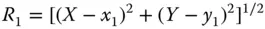
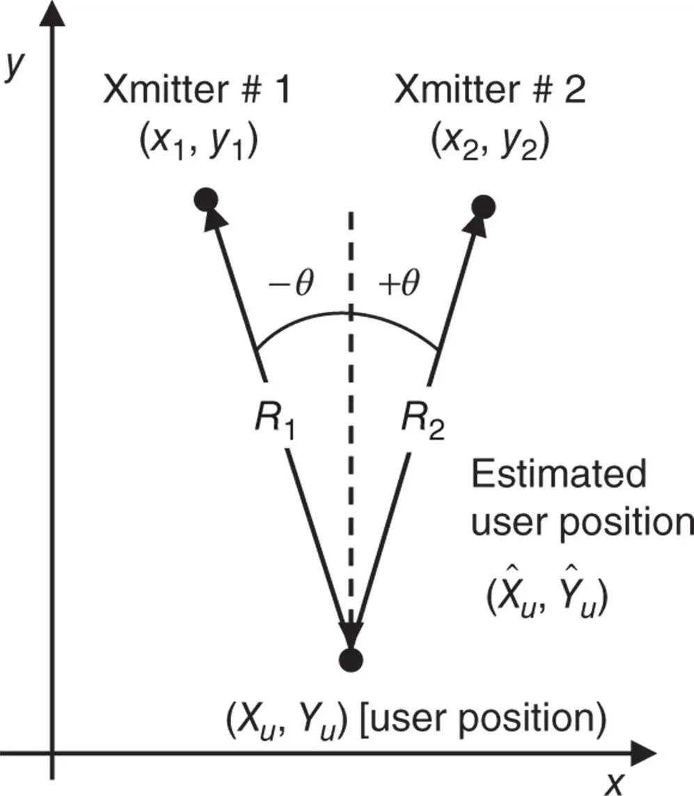
Figure 2.3Two transmitters with known 2D positions.
(2.4) 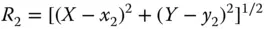
Expanding R 1and R 2in Taylor series expansion with small perturbation in X by Δ x and Y by Δ y yields
(2.5) 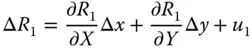
(2.6) 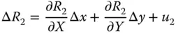
where u 1and u 2are higher‐order terms. The derivatives of Eqs. (2.3)and (2.4)with respect to X , Y are substituted into Eqs. (2.5)and (2.6), respectively.
Thus, for the symmetric case, we obtain
(2.7) 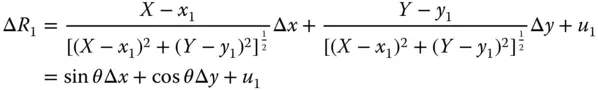
(2.8) 
To obtain the least‐squares estimate of ( X , Y ), we need to minimize the quantity
(2.9) 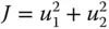
which is
(2.10) 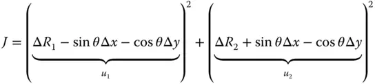
The solution for the minimum can be found by setting ∂J /∂Δ x = 0 = ∂J /∂Δ y , then solving for Δ x and Δ y :
(2.11) 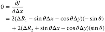
(2.12) 
with solution
(2.13) 
The solution for Δ y may be found in similar fashion as
(2.14) 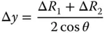
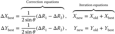
2.3.2.2 Navigation Solution Procedure
Transmitter positions x 1, y 1, x 2, y 2are known; the transmitter locations are typically provided by the GNSS satellites or known to be at a fixed surveyed location for a terrestrial source. Signal travel times Δ T 1, Δ T 2are measured by the system. Initially, the user positions  are assumed. Set position coordinates X , Y equal to their initial estimates:
Compute the range errors:
(2.15) 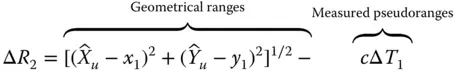
(2.16) 
Compute the θ angle (see Figure 2.3):
(2.17) 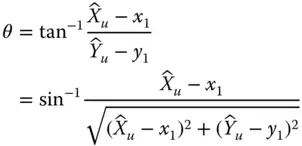
Compute update to user position:
(2.18) 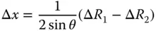
(2.19) 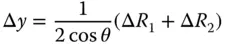
Compute a new estimate of position using the update:
(2.20) 
Continue to compute θ , Δ R 1, and Δ R 2from these equations with new values of  . Iterate Eqs. (2.15)– (2.20)and stop when Δ x and Δ y become less than the desired accuracy:
2.3.3 User Solution and Dilution of Precision (DOP)
Just as in a land‐based system, better accuracy is obtained by using reference points (i.e. ranging sources) well separated in space. For example, the range measurements made to four reference points clustered together will yield nearly equal values. Position calculations involve range differences, and where the ranges are nearly equal, small relative errors are greatly magnified in the difference. This effect, brought about as a result of satellite geometry, is known as dilution of precision (DOP). This means that range errors that occur from other independent effects such as multipath, atmospheric delays, and/or satellite clock errors are also magnified by the geometric effect.
Читать дальшеИнтервал:
Закладка:
Похожие книги на «Global Navigation Satellite Systems, Inertial Navigation, and Integration»
Представляем Вашему вниманию похожие книги на «Global Navigation Satellite Systems, Inertial Navigation, and Integration» списком для выбора. Мы отобрали схожую по названию и смыслу литературу в надежде предоставить читателям больше вариантов отыскать новые, интересные, ещё непрочитанные произведения.


Обсуждение, отзывы о книге «Global Navigation Satellite Systems, Inertial Navigation, and Integration» и просто собственные мнения читателей. Оставьте ваши комментарии, напишите, что Вы думаете о произведении, его смысле или главных героях. Укажите что конкретно понравилось, а что нет, и почему Вы так считаете.