Jakob J. Zyl - Introduction to the Physics and Techniques of Remote Sensing
Здесь есть возможность читать онлайн «Jakob J. Zyl - Introduction to the Physics and Techniques of Remote Sensing» — ознакомительный отрывок электронной книги совершенно бесплатно, а после прочтения отрывка купить полную версию. В некоторых случаях можно слушать аудио, скачать через торрент в формате fb2 и присутствует краткое содержание. Жанр: unrecognised, на английском языке. Описание произведения, (предисловие) а так же отзывы посетителей доступны на портале библиотеки ЛибКат.
- Название:Introduction to the Physics and Techniques of Remote Sensing
- Автор:
- Жанр:
- Год:неизвестен
- ISBN:нет данных
- Рейтинг книги:3 / 5. Голосов: 1
-
Избранное:Добавить в избранное
- Отзывы:
-
Ваша оценка:
Introduction to the Physics and Techniques of Remote Sensing: краткое содержание, описание и аннотация
Предлагаем к чтению аннотацию, описание, краткое содержание или предисловие (зависит от того, что написал сам автор книги «Introduction to the Physics and Techniques of Remote Sensing»). Если вы не нашли необходимую информацию о книге — напишите в комментариях, мы постараемся отыскать её.
delivers a comprehensive update to the authoritative textbook, offering readers new sections on radar interferometry, radar stereo, and planetary radar. It explores new techniques in imaging spectroscopy and large optics used in Earth orbiting, planetary, and astrophysics missions. It also describes remote sensing instruments on, as well as data acquired with, the most recent Earth and space missions.
Readers will benefit from the brand new and up-to-date concept examples and full-color photography, 50% of which is new to the series. You’ll learn about the basic physics of wave/matter interactions, techniques of remote sensing across the electromagnetic spectrum (from ultraviolet to microwave), and the concepts behind the remote sensing techniques used today and those planned for the future.
The book also discusses the applications of remote sensing for a wide variety of earth and planetary atmosphere and surface sciences, like geology, oceanography, resource observation, atmospheric sciences, and ionospheric studies. This new edition also incorporates:
A fulsome introduction to the nature and properties of electromagnetic waves An exploration of sensing solid surfaces in the visible and near infrared spectrums, as well as thermal infrared, microwave, and radio frequencies A treatment of ocean surface sensing, including ocean surface imaging and the mapping of ocean topography A discussion of the basic principles of atmospheric sensing and radiative transfer, including the radiative transfer equation Perfect for senior undergraduate and graduate students in the field of remote sensing instrument development, data analysis, and data utilization,
will also earn a place in the libraries of students, faculty, researchers, engineers, and practitioners in fields like aerospace, electrical engineering, and astronomy.
Introduction to the Physics and Techniques of Remote Sensing — читать онлайн ознакомительный отрывок
Ниже представлен текст книги, разбитый по страницам. Система сохранения места последней прочитанной страницы, позволяет с удобством читать онлайн бесплатно книгу «Introduction to the Physics and Techniques of Remote Sensing», без необходимости каждый раз заново искать на чём Вы остановились. Поставьте закладку, и сможете в любой момент перейти на страницу, на которой закончили чтение.
Интервал:
Закладка:
The capabilities of remote sensing satellites have also dramatically increased over the past three decades. The number of spectral channels available has grown from a few to more than 200 in the case of the Hyperion instrument. Resolutions of a few meters or less are now available from commercial vendors. Synthetic aperture radars are now capable of collecting images on demand in many different modes. Satellites are now acquiring images of other planets in more spectral channels and with better resolutions than what was available for the Earth two decades ago. And as the remote sensing data have become more available, the number of applications has grown. In many cases, the limitation now has shifted from the technology that acquires the data to the techniques and training to optimally exploit the information embedded in the remote sensing data.
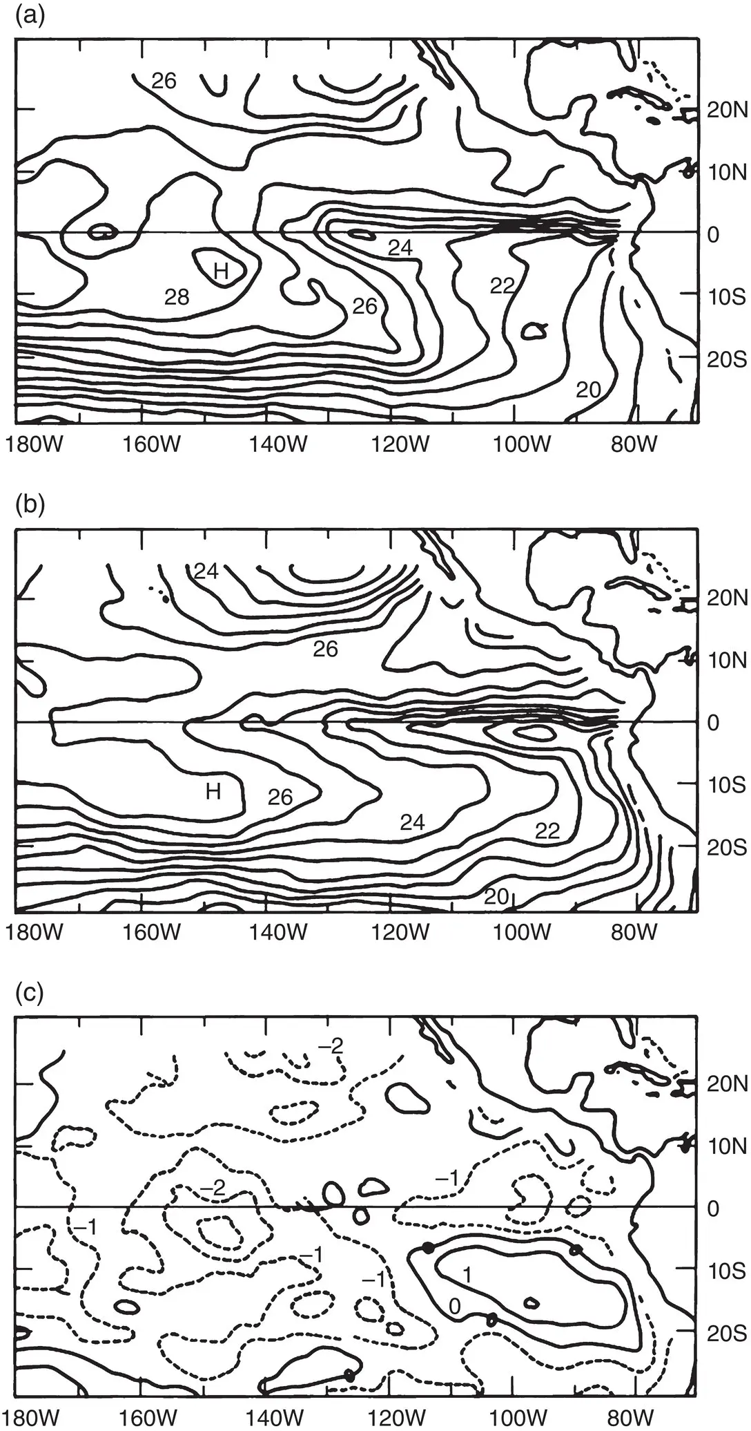
Figure 1.11 Sea surface temperature derived from ship observations (a) and from the Seasat Multispectral Microwave Radiometer (b). (c) shows the difference.
Source: From Liu (1983). © 1983, John Wiley & Sons.
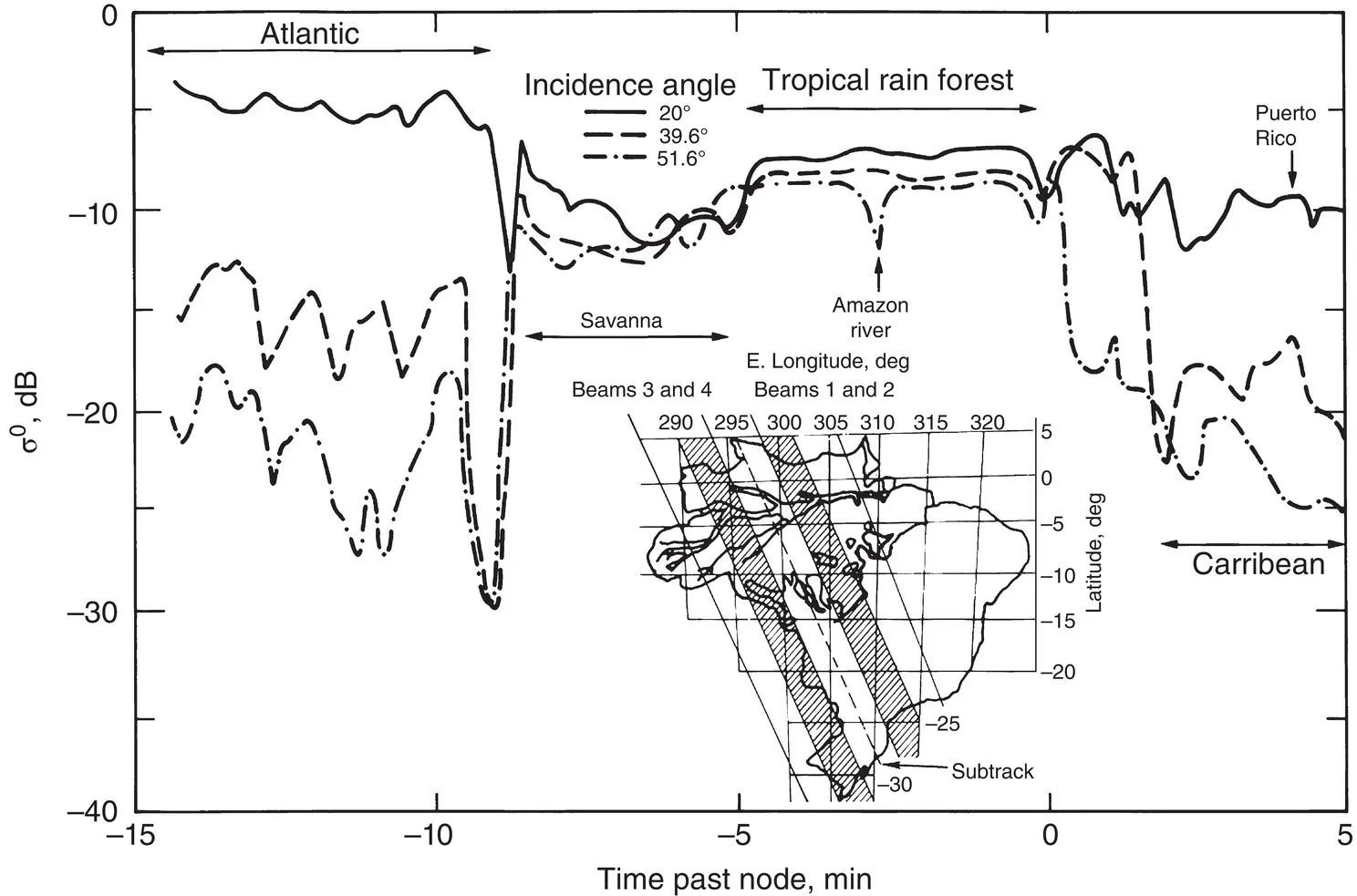
Figure 1.12 Backscatter data acquired over the Amazon region (insert). The different curves correspond to different incidence angles. Data were acquired by the Seasat Scatterometer at 14.6 GHz and at VV polarization.
Source: Bracalante et al. (1980). © 1980, IEEE.
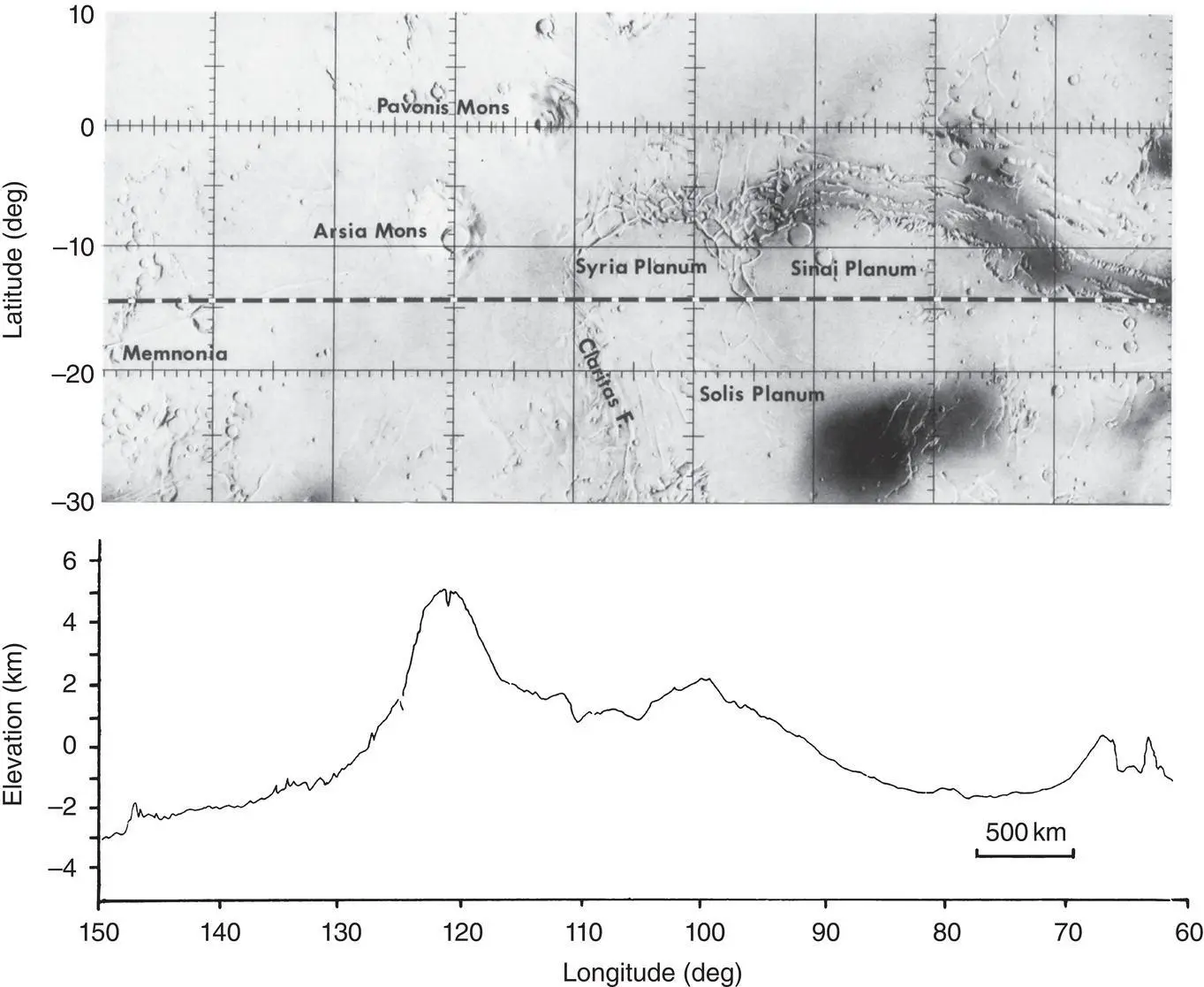
Figure 1.13 Profile of Tharsis region (Mars) acquired with Earth‐based radar.
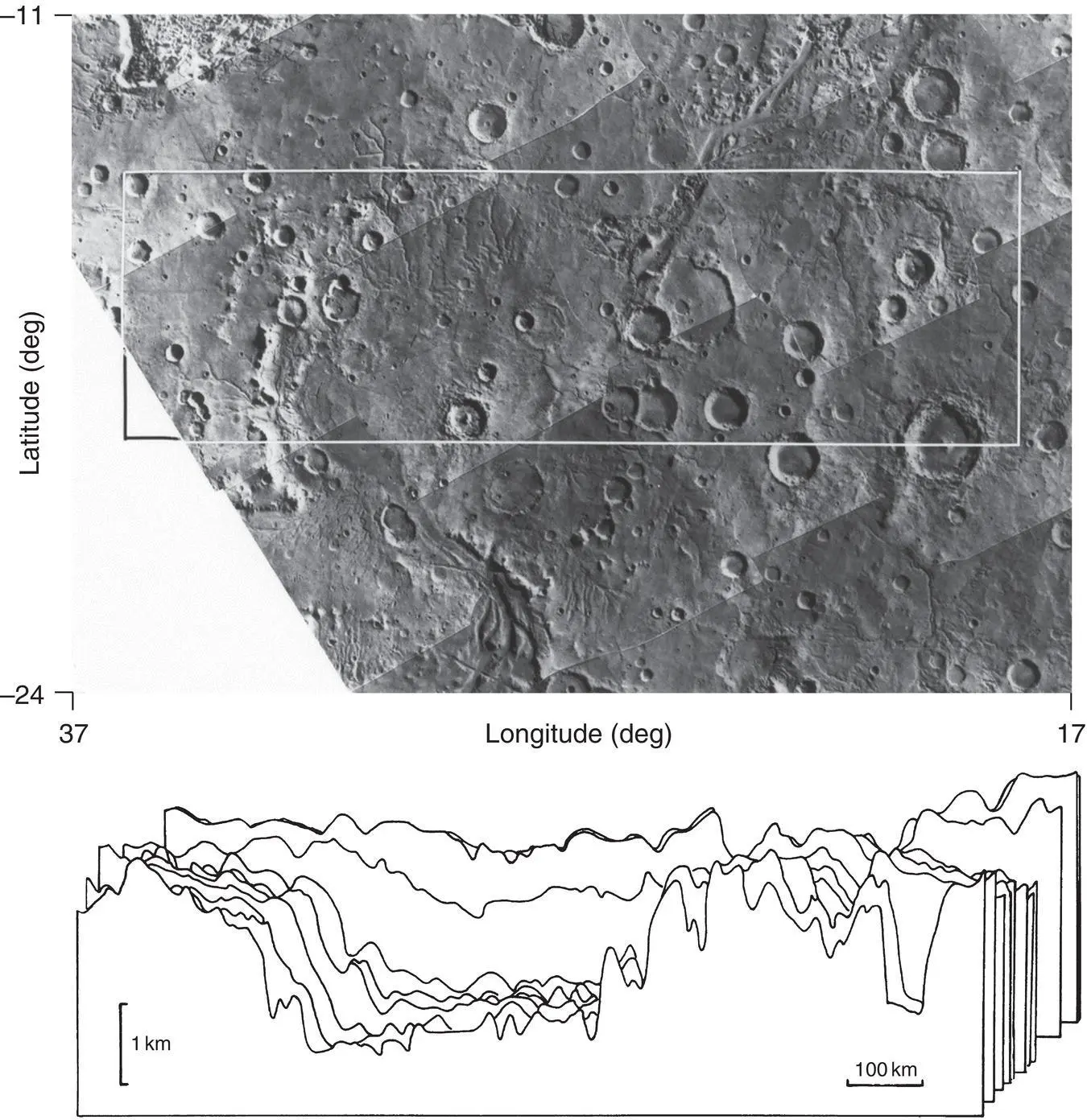
Figure 1.14Profiles of an unnamed impact basin on Mars using Earth‐based radar. The set of profiles shown correspond to the box overlay on the figure.
1.3 Remote Sensing Space Platforms
Up until 1946, remote sensing data were mainly acquired from airplanes or balloons. In 1946, pictures were taken from V‐2 rockets. The sounding rocket photographs proved invaluable in illustrating the potential value of photography from orbital altitudes. Systematic orbital observations of the Earth began in 1960 with the launch of Tiros I, the first meteorological satellite, using a low‐resolution imaging system. Each Tiros spacecraft carried a narrow‐angle TV, five‐channel scanning radiometer, and a bolometer.
In 1961, orbital color photography was acquired by an automatic camera in the unmanned MA‐4 Mercury spacecraft. This was followed by photography acquired during the Mercury, Gemini, Apollo, and Skylab missions. On Apollo 9, the first multispectral images were acquired to assess their use for Earth resources observation. This was followed by the launch in 1972 of the first Earth Resources Technology Satellite (ERTS‐1, later renamed Landsat‐1), which was one of the major milestones in the field of Earth remote sensing. ERTS‐1 was followed by the series of Landsat missions.
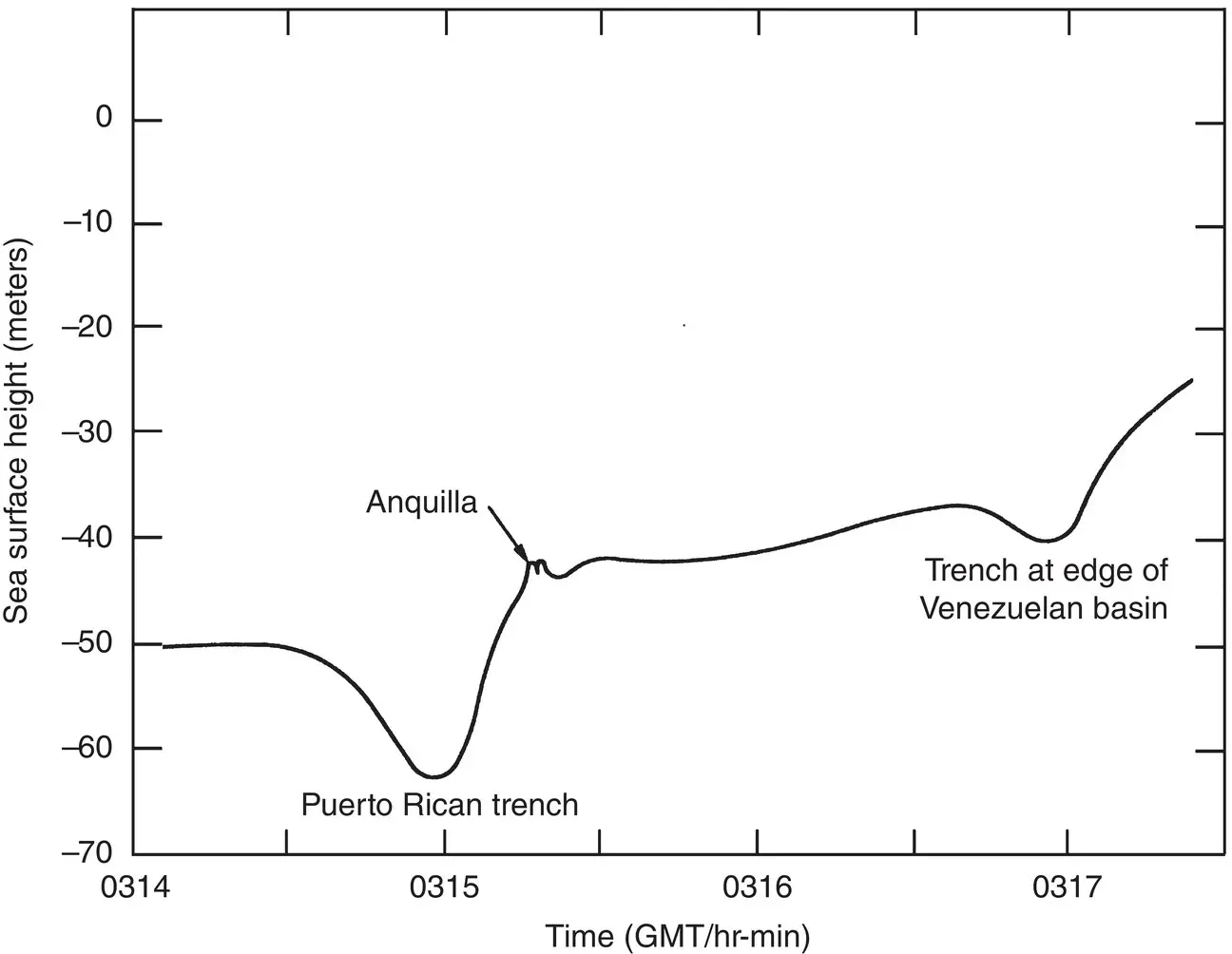
Figure 1.15Sea surface height over two trenches in the Caribbean acquired with the Seasat altimeter.
Source : Townsend (1980). © 1980, IEEE.
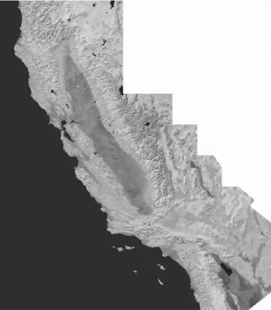
Figure 1.16 Shaded relief display of the topography of California measured by Shuttle Radar Topography Mission using an interferometric SAR.
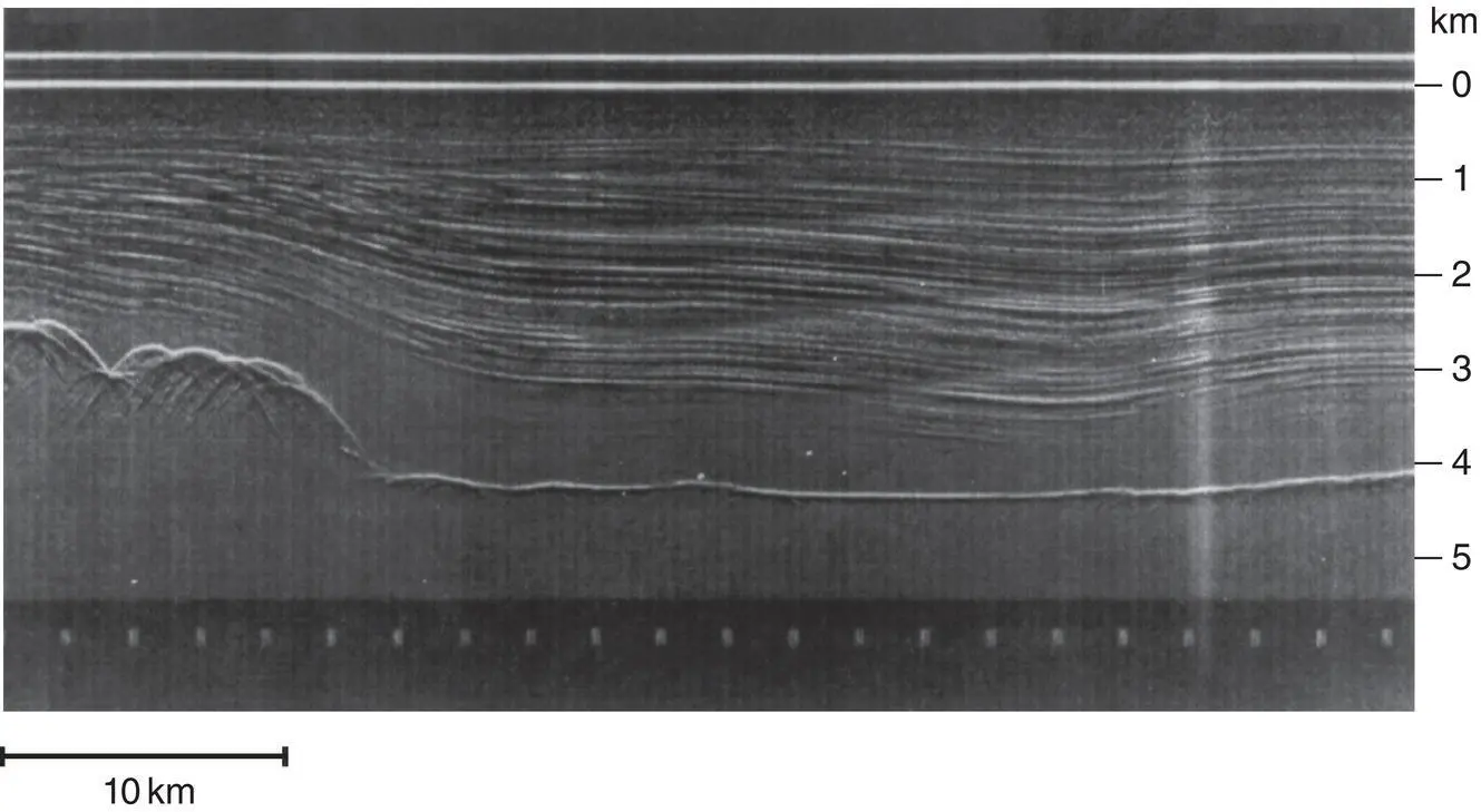
Figure 1.17 Subsurface layering in the ice cover and bedrock profile acquired with an airborne electromagnetic sounder over a part of the Antarctic ice sheet.
Earth orbital spacecraft were also used to acquire remote sensing data other than regular photography. To name just a few, the Nimbus spacecraft carry passive microwave radiometers, infrared spectrometers, and infrared radiometers. The Synchronous Meteorological Satellite (SMS) carried visible and IR spin‐scan cameras. Skylab (1972) carried a radiometer and a radar scatterometer. Seasat (1978) carried an imaging radar, a scatterometer, and an altimeter.
In the 1980s and 1990s, the Space Shuttle provided an additional platform for remote sensing. A number of shuttle flights carried imaging radar systems. In particular, the Shuttle Radar Topography Mission, flown on the Space Shuttle in 2000, allowed global mapping of the Earth’s topography.
Remote sensing activity was also expanding dramatically using planetary spacecraft. Images were acquired of the surfaces of the Moon, Mercury, Venus, Mars, the Jovian and Saturnian satellites, Pluto, numerous Asteroids and comets, and of the atmospheres of Venus, Jupiter, Saturn Uranus, and Neptune. Other types of remote sensors, such as radar altimeters, sounders, gamma‐ray detectors, infrared radiometers, and spectrometers were used on a number of planetary missions.
The use of orbiting spacecraft is becoming a necessity in a number of geophysical disciplines because they allow the acquisition of global and synoptic coverage with a relatively short repetitive period. These features are essential for observing dynamic atmospheric, oceanic, and biologic phenomena. The global coverage capability is also essential in a number of geologic applications where large‐scale structures are being investigated. In addition, planetary rovers are using remote sensing instruments to conduct close‐up analysis of planetary surfaces. Over the last decade, with the advances in detectors, light optics, microwave technology, antennas, materials, spacecraft technology and data systems, there has been a great expansion in the development, deployment, and utilization of remote sensors. These will be discussed throughout this textbook.
1.4 Transmission Through the Earth and Planetary Atmospheres
The presence of an atmosphere puts limitations on the spectral regions that can be used to observe the underlying surface. This is a result of wave interactions with atmospheric and ionospheric constituents leading to absorption or scattering in specific spectral regions ( Figure 1.19).
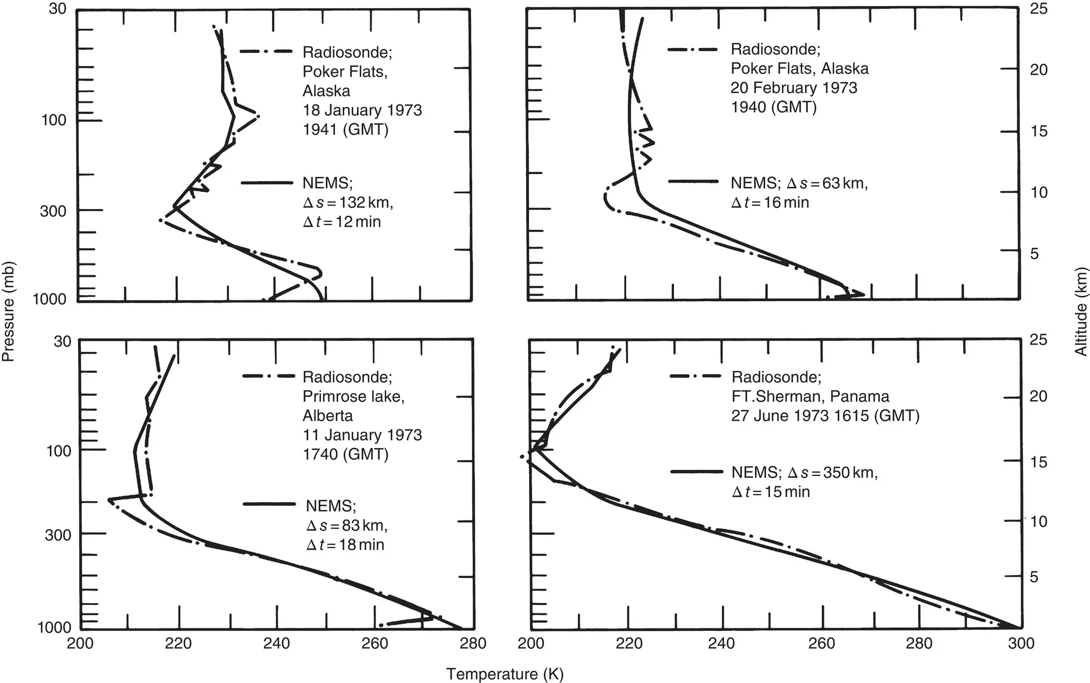
Figure 1.18 Comparison of temperature profiles acquired with a microwave sounder (NEMS) and radiosonde. The spatial and temporal differences, Δ s and Δ t , between the two measurements are indicated.
Source : Waters et al. (1975). © 1975, American Meteorological Society.
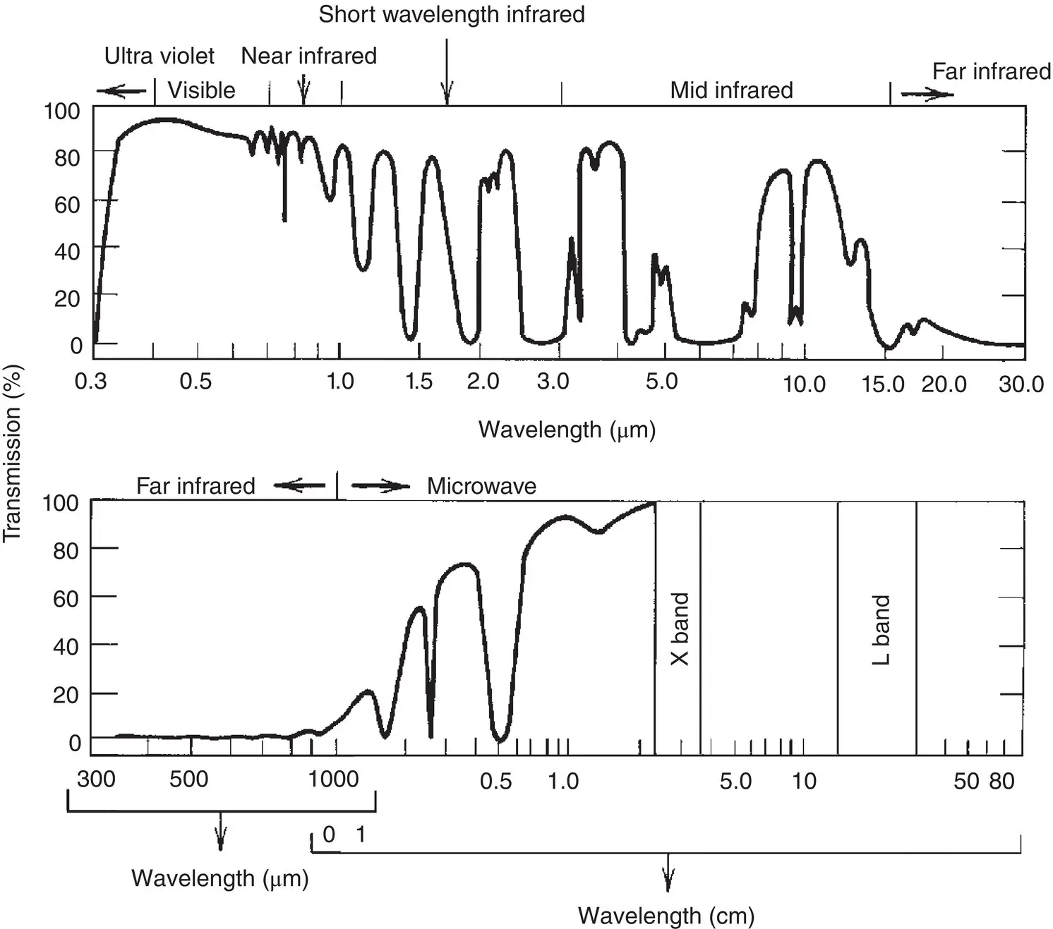
Figure 1.19 Generalized absorption spectrum of the Earth’s atmosphere at zenith. The curve shows the total atmospheric transmission.
Читать дальшеИнтервал:
Закладка:
Похожие книги на «Introduction to the Physics and Techniques of Remote Sensing»
Представляем Вашему вниманию похожие книги на «Introduction to the Physics and Techniques of Remote Sensing» списком для выбора. Мы отобрали схожую по названию и смыслу литературу в надежде предоставить читателям больше вариантов отыскать новые, интересные, ещё непрочитанные произведения.


Обсуждение, отзывы о книге «Introduction to the Physics and Techniques of Remote Sensing» и просто собственные мнения читателей. Оставьте ваши комментарии, напишите, что Вы думаете о произведении, его смысле или главных героях. Укажите что конкретно понравилось, а что нет, и почему Вы так считаете.