Jerry T. Mitchell - Geography For Dummies
Здесь есть возможность читать онлайн «Jerry T. Mitchell - Geography For Dummies» — ознакомительный отрывок электронной книги совершенно бесплатно, а после прочтения отрывка купить полную версию. В некоторых случаях можно слушать аудио, скачать через торрент в формате fb2 и присутствует краткое содержание. Жанр: unrecognised, на английском языке. Описание произведения, (предисловие) а так же отзывы посетителей доступны на портале библиотеки ЛибКат.
- Название:Geography For Dummies
- Автор:
- Жанр:
- Год:неизвестен
- ISBN:нет данных
- Рейтинг книги:5 / 5. Голосов: 1
-
Избранное:Добавить в избранное
- Отзывы:
-
Ваша оценка:
Geography For Dummies: краткое содержание, описание и аннотация
Предлагаем к чтению аннотацию, описание, краткое содержание или предисловие (зависит от того, что написал сам автор книги «Geography For Dummies»). Если вы не нашли необходимую информацию о книге — напишите в комментариях, мы постараемся отыскать её.
Geography For Dummies
Geography For Dummies
Geography For Dummies — читать онлайн ознакомительный отрывок
Ниже представлен текст книги, разбитый по страницам. Система сохранения места последней прочитанной страницы, позволяет с удобством читать онлайн бесплатно книгу «Geography For Dummies», без необходимости каждый раз заново искать на чём Вы остановились. Поставьте закладку, и сможете в любой момент перейти на страницу, на которой закончили чтение.
Интервал:
Закладка:
Verbal scale
A verbal scale (also called statement of scale ) communicates the relationship between map distance and real-world distance in a sentence or sentence-like format. In Figure 5-1, “One inch equals one mile” is the example. (By the way, if you want to know why a mile is a mile, see the nearby sidebar “Whence comes the mile?”)
As far as most people are concerned, the verbal scale is particularly convenient for measuring distances on a map, provided a ruler is available. In the case of “one inch equals one mile,” one need only measure the number of inches between two points to arrive at the number of miles that separate them on Earth. If, on the other hand, the verbal scale on another map reads “one inch equals 20 miles,” then the number of inches between the two points on the map needs to be multiplied by 20 to render the actual distance.
 Maps come in different scales. Thus, the scale you use to calculate distance on one map may not be the same for the next map. Always check the scale before you calculate distance.
Representative fraction (RF)
 The area shown on a map is a fraction of its actual size. Appropriately, therefore, scale may be indicated as a representative fraction (RF), which states the ratio between a unit of distance on the map and the same distance measured in the same units on the ground. As far as most people are concerned, this is the most confusing scale-type and the most difficult to explain. OK, here goes.
Check out Figure 5-1 again. The RF shown is 1:63,360. That means the map is 1/63,360th the size of the area it shows. Stated differently, a distance of one inch on the map equals 63,360 inches on the Earth’s surface.
Once more, a given map has a given scale, but you can express it in different ways. In the example, therefore, “One inch equals one mile” and “1:63,360” must mean the same thing. And, indeed, they do. Proof is obtained by calculating the number of inches in a mile. To do that, multiply the number of inches per foot times the number of feet per mile (12 × 5,280). The answer is 63,360, so the statement of scale and the RF are, in fact, the same.
Comparing Earth at different scales
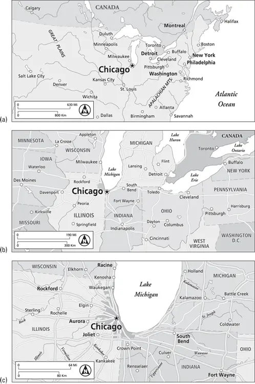
Maps come in different scales; and because they do, the amount of area and degree of detail shown on one map may be very different from another. This is demonstrated in Figure 5-2, which shows three maps that have identical dimensions and progressively “zoom in” on Chicago. Specifically:
WHENCE COMES THE MILE?
A mile is a unit of linear measurement that equals 5,280 feet. While most of the world has adopted metric units (kilometers), Americans continue to express distance in miles, which, therefore, commonly appear as units of measurement on maps made in the U.S. But exactly what is a mile? And why does it consist of 5,280 feet instead of a more convenient figure, like 5,000?
“Mile” comes from the Latin milia, meaning thousand. In Roman times, a unit of linear measure called the milia passum, or thousand paces, was common. Somehow, somebody’s thousand strides became a standard Roman mile, equal to about 1,650 yards. This measurement became widely used in Britain following the Roman’s invasion. After the Empire’s demise, however, the milia passum fell into disuse, although “mile” endured in the British vocabulary as a word applicable to a substantial distance.
The mile’s present length has its origins in medieval English agriculture. Back then, a team of oxen was used to pull a heavy wooden plow. The farmer walked behind, making liberal use of an ox goad — a big stick — to influence the animals’ behavior. The stick was known as a rod, and at some point its length was standardized to 16.5 feet. The length of a parcel of farmland was “a furrow long,” or furlong. That was the distance the oxen could pull the plow before the farmer had to stop and rest them. Naturally, that length varied. In time, however, the furlong was standardized to a distance of 40 rods (660 feet or 220 yards). Sometime later, a distance of 8 furlongs (5,280 feet or 1,760 yards) became the standard mile, and remains so to this day.
In Figure 5-2a, 1 inch represents 630 miles. As a result, this map shows a comparatively large area that includes most of the Great Lakes, Upper Midwest, a handful of major cities, and a portion of Canada.
In Figure 5-2b, 1 inch represents 190 miles. What is shown now is a much smaller area that includes parts of Lake Michigan and Midwest states, a few medium-size towns, and a few major regional highways.
In Figure 5-2c, 1 inch represents 64 miles. Now we have “zoomed in” to the extent that the map shows Greater Chicago, southern-most Lake Michigan, more municipalities, local highways, and several streets.
Notice that as the area shown on these maps decreases, the amount of detail increases. And if you think about it, that makes a great deal of sense. When 1 inch represents 630 miles — a large area — only very large surface features (such as the Great Lakes) can be shown. But when 1 inch represents 64 miles — a much smaller area — then comparatively small surface features (such as roads) can be effectively shown.
(© John Wiley & Sons Inc.)
FIGURE 5-2:These three maps have different scales, and therefore differ in area and detail.
In the lingo of cartography, small-scale maps show large areas in little detail, while large-scale maps show small areas in big detail. Figure 5-2a has a comparatively small scale. In contrast, Figure 5-2b has a somewhat larger scale, while Figure 5-2c has the largest scale among the three maps. And indeed, as the scales of these maps get larger, the degree of detail increases. Calling the first map a small-scale map makes sense as the representative fraction, if actually divided, would result in a much smaller number than the other two maps.
Showing the Ups and Downs: Topography
All points on Earth have an elevation with respect to sea level. Altogether, they constitute “the lay of the land.” (Keep in mind that elevation also pertains to points on the ocean’s bottom.) Topography is the art and science of depicting heights and depths on a map. Like scale, topographic information is a basic feature of many maps and is commonly represented in three ways as indicated in Figure 5-3. The following sections discuss the three ways of showing topographic information.

(© John Wiley & Sons Inc.)
FIGURE 5-3:The terrain of a make-believe place, as depicted three ways.
Читать дальшеИнтервал:
Закладка:
Похожие книги на «Geography For Dummies»
Представляем Вашему вниманию похожие книги на «Geography For Dummies» списком для выбора. Мы отобрали схожую по названию и смыслу литературу в надежде предоставить читателям больше вариантов отыскать новые, интересные, ещё непрочитанные произведения.


Обсуждение, отзывы о книге «Geography For Dummies» и просто собственные мнения читателей. Оставьте ваши комментарии, напишите, что Вы думаете о произведении, его смысле или главных героях. Укажите что конкретно понравилось, а что нет, и почему Вы так считаете.