Jerry T. Mitchell - Geography For Dummies
Здесь есть возможность читать онлайн «Jerry T. Mitchell - Geography For Dummies» — ознакомительный отрывок электронной книги совершенно бесплатно, а после прочтения отрывка купить полную версию. В некоторых случаях можно слушать аудио, скачать через торрент в формате fb2 и присутствует краткое содержание. Жанр: unrecognised, на английском языке. Описание произведения, (предисловие) а так же отзывы посетителей доступны на портале библиотеки ЛибКат.
- Название:Geography For Dummies
- Автор:
- Жанр:
- Год:неизвестен
- ISBN:нет данных
- Рейтинг книги:5 / 5. Голосов: 1
-
Избранное:Добавить в избранное
- Отзывы:
-
Ваша оценка:
Geography For Dummies: краткое содержание, описание и аннотация
Предлагаем к чтению аннотацию, описание, краткое содержание или предисловие (зависит от того, что написал сам автор книги «Geography For Dummies»). Если вы не нашли необходимую информацию о книге — напишите в комментариях, мы постараемся отыскать её.
Geography For Dummies
Geography For Dummies
Geography For Dummies — читать онлайн ознакомительный отрывок
Ниже представлен текст книги, разбитый по страницам. Система сохранения места последней прочитанной страницы, позволяет с удобством читать онлайн бесплатно книгу «Geography For Dummies», без необходимости каждый раз заново искать на чём Вы остановились. Поставьте закладку, и сможете в любой момент перейти на страницу, на которой закончили чтение.
Интервал:
Закладка:
WHY IS AN ATLAS CALLED AN ATLAS?
An atlas is a book of maps. For the longest time, maps were published singly and tended to be stored as rolled-up scrolls standing in a corner. Gerardus Mercator was apparently the first person to compile a book of maps. His publisher decided to decorate the cover with a likeness of Atlas, the legendary Greek giant who supported Earth and the heavens on his shoulders. Other books of maps copied Mercator’s idea and the image of Atlas on the cover or title page became standard — which is why such volumes are called atlases.
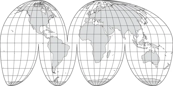
The Goode’s Interrupted Homolosine projection
Noted American cartographer Dr. J. Paul Goode (1862–1932) developed this cylindrical projection (see Figure 4-6). It’s an equal area projection, which means that the land areas are shown in their true sizes relative to each other. In that respect, Goode’s projection is far superior to Mercator’s. Interrupted refers to the map’s outline. Earth is cut into once above the Equator and three times below it. Therefore, the Northern Hemisphere appears as two lobes and the Southern Hemisphere as four lobes.
(© John Wiley & Sons Inc.)
FIGURE 4-6:Goode’s Interrupted Homolosine projection.
As a result, the map’s outline is not a rectangle or some other compact form, but instead is interrupted. The word homolosine reflects the fact that Goode’s map is a combination of two other projections: the Mollweide homolographic and the Sinusoidal. (Whether or not you ever learn what that means, I will be happy to give you extra-credit for correct spellings.) Although Goode’s projection appears in various atlases and despite its desirable equal-area attribute, many people are visually uncomfortable with its interrupted format.
The Robinson projection
Dr. Arthur H. Robinson, a noted American cartographer, introduced this cylindrical projection in 1963 (see Figure 4-2). If you lie really well, people may not notice. In fact, they may love you because of it. With all due respect and admiration to the good doctor, his map lies really well!
Although the projection contains distortion with respect to size and shape of land areas as well as to distance and direction, it has good overall balance with respect to these elements. In particular, the high latitude land areas are much less distorted than in the Mercator projection. Furthermore, Robinson’s format does not have the interruptions of Goode’s map. As a result of these pluses, the Robinson projection has become one of the popular choices among publishers of atlases and classroom wall maps.
The Lambert Conformal Conic projection
Johann Heinrich Lambert (1728–1777), a noted German physicist and mathematician, developed the Lambert Conformal Conic projection in 1772 (see Figure 4-7). Projections cannot correctly show the shapes of large areas, but they can be drafted such that the shapes of small areas closely conform to reality. That is what the Lambert Conformal Conic Projection achieves.
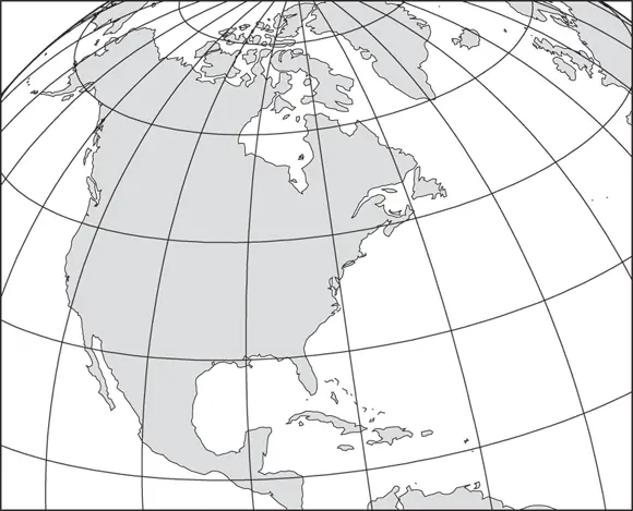
(© John Wiley & Sons Inc.)
FIGURE 4-7:Lambert Conformal Conic projection.
Accuracy of shape ( conformality ) is most closely achieved where the cone, which is intrinsic to a conic projection, touches the globe. If you refer back to Figure 4-4, you can see that the conic projection makes contact in the latitudinal vicinity of the United States. For Americans, therefore, this projection is noteworthy because it is commonly used to make maps of their country.
The Lambert Azimuthal Equal Area projection
The same Herr Lambert who developed the conformal conic projection (see the preceding section) presented the Lambert Azimuthal Equal Area projection in 1772 (see Figure 4-3). Because it’s an azimuthal projection, as shown in Figure 4-4, it portrays only a hemisphere, as opposed to the entire world. On the other hand, it has two positive aspects: Areas are shown in true proportion to the same areas on Earth and, as revealed in my New York-to-Singapore exercise (see “ Singapore, please. And step on it!” earlier in this chapter), long-range directions are depicted with a fair amount of accuracy.
Mapping a Cartographic Controversy!
If you’re under the impression that the world of map-making is rather staid and geeky, you’re right. In recent decades, however, a map known as the Peters projection has come along and stirred things up. An episode of the television series The West Wing showed just how geeky, wonky, and controversial map projections like Peters can be. Although this projection is controversial to some, it serves as an excellent example of why average citizens and novice geographers ought to know the facts about flat maps.
The Peters projection was introduced and subsequently promoted in 1972 by Arno Peters, a German historian (see Figure 4-8). It’s also the subject of his book The New Cartography (Die Neue Kartographie). As far as accurately showing the world is concerned, this map lies just like any other. The appearance of the continents has been likened to wet laundry hanging out to dry. The shape of land and water bodies is badly distorted, but size is maintained.
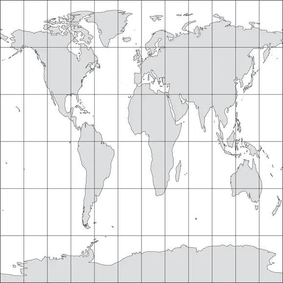
(© John Wiley & Sons Inc.)
FIGURE 4-8:The Peters projection.
This size issue is key for advocates of the Peters projection, saying that it renders an important measure of cartographic justice for tropical less-developed regions. They claim that by inflating the size of high-latitude regions relative to the tropics, the Mercator and some other projections present a Europe-centered view of the world that denigrates places in Asia, Africa, and South America. Proponents point out that the Peters projection is an equal area projection that shows tropical regions in their true size relative to, say, Europe and North America. As a result of such advocacy, several agencies with strong interests in these places have adopted the Peters projection as their official depiction of the world.
But is this projection really any better than the others? When you look at the facts of the matter, three things are obvious:
First, the Peters projection terribly distorts shape (especially near the Poles and Equator) and distance.
Second, there is a perfectly good alternative to the Peters that is an equal area map and depicts shape of tropical regions with considerable accuracy — the Goode’s projection.
Third, there is nothing new about The New Cartography. The Peters projection is a knock-off of a projection that was developed by James Gall in 1885. As result, it is usually called the Gall-Peters projection nowadays.
 So, is there one perfect world projection that lies flat without lying? No. Is there one perfect projection for all situations? Again, no. Representing Earth cartographically can be as crazy as all the physical and human features contained within it. Do your best!
Chapter 5
Telling a Spatial Story
Интервал:
Закладка:
Похожие книги на «Geography For Dummies»
Представляем Вашему вниманию похожие книги на «Geography For Dummies» списком для выбора. Мы отобрали схожую по названию и смыслу литературу в надежде предоставить читателям больше вариантов отыскать новые, интересные, ещё непрочитанные произведения.


Обсуждение, отзывы о книге «Geography For Dummies» и просто собственные мнения читателей. Оставьте ваши комментарии, напишите, что Вы думаете о произведении, его смысле или главных героях. Укажите что конкретно понравилось, а что нет, и почему Вы так считаете.