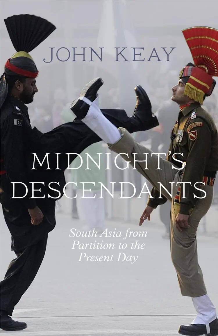
John Keay - Midnight’s Descendants - South Asia from Partition to the Present Day
Здесь есть возможность читать онлайн «John Keay - Midnight’s Descendants - South Asia from Partition to the Present Day» — ознакомительный отрывок электронной книги совершенно бесплатно, а после прочтения отрывка купить полную версию. В некоторых случаях можно слушать аудио, скачать через торрент в формате fb2 и присутствует краткое содержание. Жанр: unrecognised, на английском языке. Описание произведения, (предисловие) а так же отзывы посетителей доступны на портале библиотеки ЛибКат.
- Название:Midnight’s Descendants: South Asia from Partition to the Present Day
- Автор:
- Жанр:
- Год:неизвестен
- ISBN:нет данных
- Рейтинг книги:3 / 5. Голосов: 1
-
Избранное:Добавить в избранное
- Отзывы:
-
Ваша оценка:
Midnight’s Descendants: South Asia from Partition to the Present Day: краткое содержание, описание и аннотация
Предлагаем к чтению аннотацию, описание, краткое содержание или предисловие (зависит от того, что написал сам автор книги «Midnight’s Descendants: South Asia from Partition to the Present Day»). Если вы не нашли необходимую информацию о книге — напишите в комментариях, мы постараемся отыскать её.
Midnight’s Descendants: South Asia from Partition to the Present Day — читать онлайн ознакомительный отрывок
Ниже представлен текст книги, разбитый по страницам. Система сохранения места последней прочитанной страницы, позволяет с удобством читать онлайн бесплатно книгу «Midnight’s Descendants: South Asia from Partition to the Present Day», без необходимости каждый раз заново искать на чём Вы остановились. Поставьте закладку, и сможете в любой момент перейти на страницу, на которой закончили чтение.
Интервал:
Закладка:
‘These people here must be Indian then,’ I venture. Fishing boats and a gaggle of schoolchildren hint at a nearby village, but there is no mains electricity, no road and no phone line – and all this despite being within 150 kilometres of downtown Calcutta.
‘Well yes, now they’re mostly Indian. But many of them are actually from Bangladesh, some Hindu, some Muslim.’
In the Sundarbans the rivers and raptors are not the only changeable things. Decades after British-ruled India was partitioned into the republics of India, Pakistan and later Bangladesh, national identities in this part of the subcontinent remain as fluid as the wind-ruffled soup that passes for water. So, too, do patterns of migration and the terminology applied to them. Immediately after the Great Partition of 1947, people who crossed the border were known as ‘refugees’. In the 1960s they became ‘evacuees’, in the 1970s either ‘optees’ or ‘oustees’, in the 1980s ‘illegal immigrants’, and now ‘potential terrorists’. Like the reception afforded them in their chosen destination, their status has been declining. Not, though, their numbers. The exodus into India from that part of Pakistan which in 1971 became Bangladesh has always been difficult to quantify. Some say hundreds of thousands have crossed the border, some say millions. Urban India’s twenty-first-century construction boom draws heavily on Bangladeshi labour, much of it illegal. Locally there are migrants who traipse back and forth for seasonal work or even a daily wage. No one is sure who is a migrant worker and who a cross-border commuter. Throughout the delta, people still come and go largely undetected, like the tides and the tigers.
A thousand kilometres to the north, where the Bangladesh border squeezes the Indian state of West Bengal up against the Himalayas, the situation is further complicated by what must be the most eccentric frontier conformation on earth. Here territorial logic veers to the opposite extreme, that of over-definition. Communities lie trapped in time-warped pockets, their national identity determined by arcane landholding patterns and the inflexible notions of sovereignty so jealously entertained by modern nation states. With little regard to the religious affinities of the inhabitants, Partition here simply appropriated the piecemeal patterns of cultivation and proprietorship found in the extant land registers and then upgraded them into international borders.
Outside his house a man poses for the camera. His back is to the wall in the photo and his legs apart. He looks rather pleased with himself. The caption explains that he is standing with one foot in Bangladesh and the other in India, and that the wall behind him is part of an extension tacked onto his house so that it too straddles the international border. With a spare room in India he qualifies as an Indian resident and can avail himself of a connection to the Indian electricity grid. No one else in this bit of Bangladesh has electricity. Providing any social amenities here is problematic because the village is in fact a sovereign ‘enclave’.
An enclave is any atoll of territory wholly surrounded by the territory of another sovereign state, in this case India. Elsewhere there are bits of India stranded in Bangladesh. The border picks its way between these enclaves, and such is their complexity that most maps despair of showing them at all. But on the ground the formalities of international transfer are faithfully observed. Checkpoints bar the tiniest roads; flags are raised and lowered; papers are stamped, currency changed, sim cards traded and bribes disbursed. Cultivators setting off for their fields clutch passports; cross-border shopping trips may be construed as smuggling operations.
Willem van Schendel, Professor of Modern Asian History in the Netherlands (a country which has enclaves of its own in Belgian territory), estimates that there are 197 such sovereign pockets along this short section of the Indo–Bangladesh border west of the Tista river. Perhaps 100,000 people live in the enclaves, which cover a total area of about 120 square kilometres. It’s hard to be more precise, because enclaves may themselves have enclaves. The latter are known as ‘counter-enclaves’ and are, in effect, bits of India that lie within bits of Bangladesh that are themselves within India – or vice versa. In the Bhalapura Khagrabari complex of enclaves, the largest archipelago of Indian territory in Bangladesh, one such Bangladeshi counter-enclave contains a smaller counter-enclave of Indian territory. This is Dahala Khagrabari, which van Schendel calls ‘the world’s only counter-counter-enclave’. From here an Indian citizen wishing to reach India proper, a distance of around ten kilometres, has to cross the frontier four times – from India to Bangladesh, Bangladesh to India, India to Bangladesh and finally Bangladesh to the Indian ‘mainland’. Luckily Dahala Khagrabari comprises just 6.9 hectares and is currently uninhabited, being mostly jute fields. But envy not its farmer.
With their promise of sanctuary, enclaves have attracted unsavoury elements. Criminal gangs have tended to take up residence, and smuggling has become a way of life. Under cover of darkness or along paths tunnelled through the three-metre-high jute crop, everything from armaments to cattle, pharmaceuticals and people is channelled through the enclaves. In recent years criminal activity has reportedly been on the decline; life, though, remains ‘insecure’ and social amenities non-existent. The only obvious advantage of being an enclave-dweller is said to be ‘the absence of tax’. 1
Something similar could be said of another anomaly of the Indo–Bangladesh border, namely the chars. These are mid-river mudbanks deposited principally by the flood-prone waters of the wide Brahmaputra. A quarter of a million people live on chars ; the riverine soil can be very fertile and the river itself is rich in fish. But they do so at the risk not only of inundation but of involuntary migration; for such is the landscaping power of the monsoon-swollen flood that chars may shift. If the centre of the current happens to be the recognised border – as it is for several hundred kilometres – a char that was in Bangladesh one year may well end up in India the next (or vice versa).
‘[M]ost of the islands vehemently either move forward or backward across the international riverine border,’ complains an observer concerned with the problems of policing these errant landmasses. 2Though still at the same address, several thousand people may suddenly find themselves unaccredited immigrants in a different country. Border markers get washed away, rivers change course. In some areas the painful business of border negotiation and demarcation, a process that was supposedly concluded soon after Partition in the late 1940s, is still being repeated every year.
In 2006 the Indian authorities, spurred on by the prospect of cross-border infiltrators bent on terrorism, began ring-fencing Bangladesh (not forgetting its enclaves). The new fence has steel stanchions and razor wire and is actually two fences, so creating a caged corridor along which laundry can be hung out to dry. The fence stands three metres high, and when completed will be around 2,500 kilometres long. But its march is halted by every river and, as per a previous agreement not to construct contentious facilities on the border itself, it runs a hundred to a thousand metres behind the actual line of demarcation. Thus ‘a huge quantum of precious Indian land is becoming a no-man’s land’, complains one politician. Within this strip lie villages, farmland and uncounted residents. One quite short stretch of the fence is reported as having alienated, or ‘practically disowned’, 149 villages and 90,000 people. Indian citizens are being rendered stateless and their property worthless. The issue has been raised in the Indian Parliament and aired in the press, but without eliciting any promise of compensation or resettlement. 3
Читать дальшеИнтервал:
Закладка:
Похожие книги на «Midnight’s Descendants: South Asia from Partition to the Present Day»
Представляем Вашему вниманию похожие книги на «Midnight’s Descendants: South Asia from Partition to the Present Day» списком для выбора. Мы отобрали схожую по названию и смыслу литературу в надежде предоставить читателям больше вариантов отыскать новые, интересные, ещё непрочитанные произведения.


Обсуждение, отзывы о книге «Midnight’s Descendants: South Asia from Partition to the Present Day» и просто собственные мнения читателей. Оставьте ваши комментарии, напишите, что Вы думаете о произведении, его смысле или главных героях. Укажите что конкретно понравилось, а что нет, и почему Вы так считаете.