Position, Navigation, and Timing Technologies in the 21st Century
Здесь есть возможность читать онлайн «Position, Navigation, and Timing Technologies in the 21st Century» — ознакомительный отрывок электронной книги совершенно бесплатно, а после прочтения отрывка купить полную версию. В некоторых случаях можно слушать аудио, скачать через торрент в формате fb2 и присутствует краткое содержание. Жанр: unrecognised, на английском языке. Описание произведения, (предисловие) а так же отзывы посетителей доступны на портале библиотеки ЛибКат.

- Название:Position, Navigation, and Timing Technologies in the 21st Century
- Автор:
- Жанр:
- Год:неизвестен
- ISBN:нет данных
- Рейтинг книги:5 / 5. Голосов: 1
-
Избранное:Добавить в избранное
- Отзывы:
-
Ваша оценка:
Position, Navigation, and Timing Technologies in the 21st Century: краткое содержание, описание и аннотация
Предлагаем к чтению аннотацию, описание, краткое содержание или предисловие (зависит от того, что написал сам автор книги «Position, Navigation, and Timing Technologies in the 21st Century»). Если вы не нашли необходимую информацию о книге — напишите в комментариях, мы постараемся отыскать её.
Volume 1 of
contains three parts and focuses on the satellite navigation systems, technologies, and engineering and scientific applications. It starts with a historical perspective of GPS development and other related PNT development. Current global and regional navigation satellite systems (GNSS and RNSS), their inter-operability, signal quality monitoring, satellite orbit and time synchronization, and ground- and satellite-based augmentation systems are examined. Recent progresses in satellite navigation receiver technologies and challenges for operations in multipath-rich urban environment, in handling spoofing and interference, and in ensuring PNT integrity are addressed. A section on satellite navigation for engineering and scientific applications finishes off the volume.
Volume 2 of
consists of three parts and addresses PNT using alternative signals and sensors and integrated PNT technologies for consumer and commercial applications. It looks at PNT using various radio signals-of-opportunity, atomic clock, optical, laser, magnetic field, celestial, MEMS and inertial sensors, as well as the concept of navigation from Low-Earth Orbiting (LEO) satellites. GNSS-INS integration, neuroscience of navigation, and animal navigation are also covered. The volume finishes off with a collection of work on contemporary PNT applications such as survey and mobile mapping, precision agriculture, wearable systems, automated driving, train control, commercial unmanned aircraft systems, aviation, and navigation in the unique Arctic environment.
In addition, this text:
Serves as a complete reference and handbook for professionals and students interested in the broad range of PNT subjects Includes chapters that focus on the latest developments in GNSS and other navigation sensors, techniques, and applications Illustrates interconnecting relationships between various types of technologies in order to assure more protected, tough, and accurate PNT
will appeal to all industry professionals, researchers, and academics involved with the science, engineering, and applications of position, navigation, and timing technologies.pnt21book.com
Position, Navigation, and Timing Technologies in the 21st Century — читать онлайн ознакомительный отрывок
Ниже представлен текст книги, разбитый по страницам. Система сохранения места последней прочитанной страницы, позволяет с удобством читать онлайн бесплатно книгу «Position, Navigation, and Timing Technologies in the 21st Century», без необходимости каждый раз заново искать на чём Вы остановились. Поставьте закладку, и сможете в любой момент перейти на страницу, на которой закончили чтение.
Интервал:
Закладка:
Source Locations. As stated above, a critical aspect of positioning with SOOP is how to obtain accurate and up‐to‐date knowledge of the locations of signal sources or a database of location‐dependent signatures. Typically, the source locations such as DTV transmitters can be found from a regulatory registry or by a means of intelligence. A location‐dependent signature database, however, is only available for those regions that have been surveyed beforehand. Although the general characteristics of a SOOP can be learned from the standards to which the signal design adheres or estimated with SIGINT, there are circumstances in which the locations of signal sources are difficult to obtain. Some sources may be easily moved around. It is costly to build and maintain such a database. An alternative is to apply simultaneous localization and mapping of emitting radio sources (SLAMERS) [15, 16].
Clock Errors. The clocks of SOOP transmitters are initially unknown to a user, each subject to a different bias and drift. Although there are synchronous transmitters such as the single‐frequency network (SFN) for DVB, most of SOOPs are not synchronized. For synchronous transmitters, there is only one clock error between the network and the user, which can be estimated as part of the navigation solution. However, for asynchronous transmitters, there is a clock error term for each transmitter. To solve for such clock unknowns, self‐calibration can be applied when external information is available [17]. A reference station at a known location can estimate the transmitter clock errors and pass it along to the users [18, 19]. In the same way, two collaborative users can form a single spatial difference between their timing measurements with respect to a signal source, thus eliminating the common clock error [20, 21]. Both schemes, however, require a data link and synchronization between them. Another way to remove the clock error relative to a source is to form a temporal difference, leading to differential or relative range measurements for radio dead reckoning [22–25], which can be further combined with other sensors [26–27].
Number of SOOP and poor geometric dilution of precision (GDOP). The number of “independent” SOOP sources of the same kind in a region is typically not enough for robust and precise position location. Several antennas may be mounted on the same transmission tower. This tends to produce a rather poor GDOP. The problem may be alleviated by using different types of (mixed) SOOP such as TV and cellular signals [29, 30]. Making known displacements, a way to rotate the LOS vectors, is equivalent to adding fictitious sources at different locations to improve GDOP [21, 22]. Taking orthogonal measurements (e.g. obtain AOA in addition to TOA) is another way to enable positioning with limited signal sources.
2D versus 3D. Due to the limited height of terrestrial transmitters, the position solution is most likely to be two‐dimensional (2D) rather than three‐dimensional (3D). Compensation for slant ranges is required if significant height differences among transmitters and/or users are expected. Such compensation is facilitated when a digital terrain elevation database (DTED) is available. The height can also be solved with a radar or barometric altimeter.
Multipath at Reception. At reception, severe multipath is expected, particularly in an urban environment [31]. Multipath may create deep fading. Frequency diversity coding (OFDM) and spatial diversity combining (multiple‐input multiple‐output or MIMO) are techniques for better channel equalization. Rapid fading due to motion requires agile and robust tracking of code and carrier. While non‐line‐of‐sight (NLOS) signals are desirable for communications to reach shadowed areas, it is problematic for ranging. NLOS signals can be excluded, de‐weighted, or estimated as bias with robust estimation techniques. On the other hand, multipath can be exploited for constructive use [32, 33]. It can improve the positioning geometry when NLOS paths can be resolved from an environment map. In fact, multipath is troublesome only for geometric positioning methods, but it is rather a blessing for feature‐matching based (non‐geometric) methods, where multipath makes each location rather unique in terms of a rich set of features.
Signal Integrity/Authenticity. By its very nature, the use of SOOP faces the issues of integrity and authenticity in the context of navigation warfare. The signal physical characteristics and the information content carried on the signals can be used for authentication and assurance. Mixed SOOP and other types of sensors may be used for cross‐checking to ensure source authenticity, measurement integrity, and solution viability.
40.2 Representative Terrestrial Digital Broadcasting Signals
For terrestrial broadcasting of digital TV programs, there are four major systems, and their worldwide geographic distribution is shown in Figure 40.1[6, 35, 36]. In Europe, Australia, South Africa, India, and Southeast Asia, the standard is the DVB‐T (Digital Video Broadcasting – Terrestrial). An extension of DVB‐T, known as DVB‐T2, transmits compressed digital audio, video, and other data in “physical layer pipes” with a higher bit rate.
In the United States and South Korea, the standard is the American Television Standard Committee 8‐ary vestigial sideband modulation (ATSC‐8VSB), also known as ATSC 1.0. A next‐generation standard that leapfrogs to ATSC 3.0 will make use of advanced transmission and video/audio coding techniques to bring new and creative services to viewers. It is expected to hit the first 40 US television markets by the end of 2020.
In Japan and several South American countries, the DTV system is the ISDB‐T (Integrated Services Digital Broadcasting – Terrestrial). In China, including Hong Kong and Macao, and Cuba, the DTV standard is the DTMB (Digital Terrestrial Multimedia Broadcast). The DTMB contains both options for single‐carrier transmission (ATSC‐8VSB) and multi‐carrier transmission (TDS‐OFDM).
Corresponding to these terrestrial (T) versions, there are also versions for satellite transmission (S) and/or mobile and handheld (M/H) devices for the four standards, namely, DVB‐H/SH, ISDB‐S, and ATSC‐M/H. From the point of view of extracting TOA measurements without getting into the details of source and channel coding, bit error detection and correction, and data modulation and demodulation, we will review ATSC‐8VSB DTV signals in Section 40.2.1and DVB‐T signals in Section 40.2.2, respectively, together with software receivers for acquisition and tracking. ISDB‐T, DTMB, and ATSC 3.0 are briefly presented in Sections 40.2.3, 40.2.4, and 40.2.5, respectively.
40.2.1 Acquisition and Tracking of ATSC‐8VSB Signals for Timing and Ranging
As specified in [37], the ATSC‐8VSB DTV signal stream repeats a frame structure as illustrated in Figure 40.2. Each frame consists of two fields, marked as “Field 1” and “Field 2,” respectively; each field has 313 segments, and each segment has 832 symbols. In all, there are 520,832 symbols per frame and 260,416 symbols per field. The baseband signal has a symbol rate of 10.76 mega symbols per second (Msps). At such a rate, a segment lasts 77.32 μs, a field 24.2 ms, and a frame 48.4 ms.
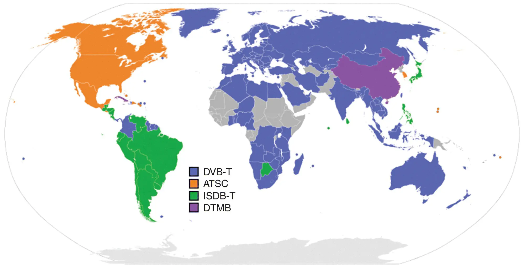
Figure 40.1 Distribution of digital broadcasting systems for terrestrial television (Wikipedia [34]).
Source: Reproduced with permission of DVB.
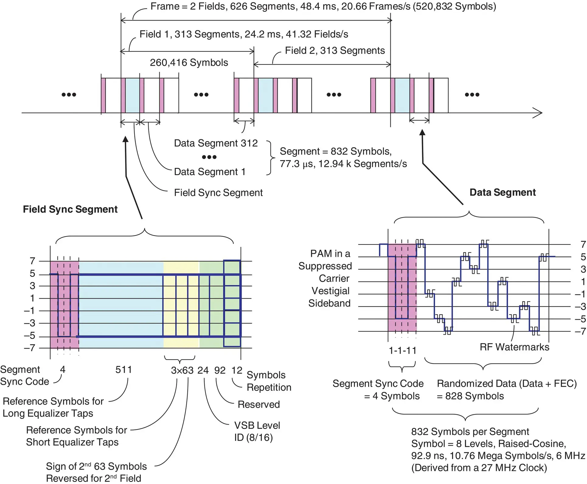
Figure 40.2 Frame structure of ATSC‐8VSB DTV signals.
Читать дальшеИнтервал:
Закладка:
Похожие книги на «Position, Navigation, and Timing Technologies in the 21st Century»
Представляем Вашему вниманию похожие книги на «Position, Navigation, and Timing Technologies in the 21st Century» списком для выбора. Мы отобрали схожую по названию и смыслу литературу в надежде предоставить читателям больше вариантов отыскать новые, интересные, ещё непрочитанные произведения.


Обсуждение, отзывы о книге «Position, Navigation, and Timing Technologies in the 21st Century» и просто собственные мнения читателей. Оставьте ваши комментарии, напишите, что Вы думаете о произведении, его смысле или главных героях. Укажите что конкретно понравилось, а что нет, и почему Вы так считаете.