Position, Navigation, and Timing Technologies in the 21st Century
Здесь есть возможность читать онлайн «Position, Navigation, and Timing Technologies in the 21st Century» — ознакомительный отрывок электронной книги совершенно бесплатно, а после прочтения отрывка купить полную версию. В некоторых случаях можно слушать аудио, скачать через торрент в формате fb2 и присутствует краткое содержание. Жанр: unrecognised, на английском языке. Описание произведения, (предисловие) а так же отзывы посетителей доступны на портале библиотеки ЛибКат.

- Название:Position, Navigation, and Timing Technologies in the 21st Century
- Автор:
- Жанр:
- Год:неизвестен
- ISBN:нет данных
- Рейтинг книги:5 / 5. Голосов: 1
-
Избранное:Добавить в избранное
- Отзывы:
-
Ваша оценка:
Position, Navigation, and Timing Technologies in the 21st Century: краткое содержание, описание и аннотация
Предлагаем к чтению аннотацию, описание, краткое содержание или предисловие (зависит от того, что написал сам автор книги «Position, Navigation, and Timing Technologies in the 21st Century»). Если вы не нашли необходимую информацию о книге — напишите в комментариях, мы постараемся отыскать её.
Volume 1 of
contains three parts and focuses on the satellite navigation systems, technologies, and engineering and scientific applications. It starts with a historical perspective of GPS development and other related PNT development. Current global and regional navigation satellite systems (GNSS and RNSS), their inter-operability, signal quality monitoring, satellite orbit and time synchronization, and ground- and satellite-based augmentation systems are examined. Recent progresses in satellite navigation receiver technologies and challenges for operations in multipath-rich urban environment, in handling spoofing and interference, and in ensuring PNT integrity are addressed. A section on satellite navigation for engineering and scientific applications finishes off the volume.
Volume 2 of
consists of three parts and addresses PNT using alternative signals and sensors and integrated PNT technologies for consumer and commercial applications. It looks at PNT using various radio signals-of-opportunity, atomic clock, optical, laser, magnetic field, celestial, MEMS and inertial sensors, as well as the concept of navigation from Low-Earth Orbiting (LEO) satellites. GNSS-INS integration, neuroscience of navigation, and animal navigation are also covered. The volume finishes off with a collection of work on contemporary PNT applications such as survey and mobile mapping, precision agriculture, wearable systems, automated driving, train control, commercial unmanned aircraft systems, aviation, and navigation in the unique Arctic environment.
In addition, this text:
Serves as a complete reference and handbook for professionals and students interested in the broad range of PNT subjects Includes chapters that focus on the latest developments in GNSS and other navigation sensors, techniques, and applications Illustrates interconnecting relationships between various types of technologies in order to assure more protected, tough, and accurate PNT
will appeal to all industry professionals, researchers, and academics involved with the science, engineering, and applications of position, navigation, and timing technologies.pnt21book.com
Position, Navigation, and Timing Technologies in the 21st Century — читать онлайн ознакомительный отрывок
Ниже представлен текст книги, разбитый по страницам. Система сохранения места последней прочитанной страницы, позволяет с удобством читать онлайн бесплатно книгу «Position, Navigation, and Timing Technologies in the 21st Century», без необходимости каждый раз заново искать на чём Вы остановились. Поставьте закладку, и сможете в любой момент перейти на страницу, на которой закончили чтение.
Интервал:
Закладка:
The concept of TBS was introduced in Release 13 of the 3GPP standards, and MBS was included as a special case of TBS. Release 13 included support for UE‐assisted measurements, pressure sensor measurement (for altitude estimation), and stand‐alone positioning for MBS. Both protocols (e.g. Location Positioning Protocol LPP document 36.355 [14]) and performance/conformance specifications (e.g. documents 37.171 [15] and 37.571 [16]) were updated to enable MBS support in Release 13. 3GPP Release 14 expanded MBS support in 36.355 [17], 37.171 [18] and 37.571 [19] to include UE‐based positioning modes as well as beacon assistance. With Release 14, the MBS system call flows and protocols have a similar level of maturity to those of A‐GNSS.
A sample LPP call flow between the server (eSMLC) and device (UE) for 3D positioning using MBS along with assistance is shown in Figure 39.20.
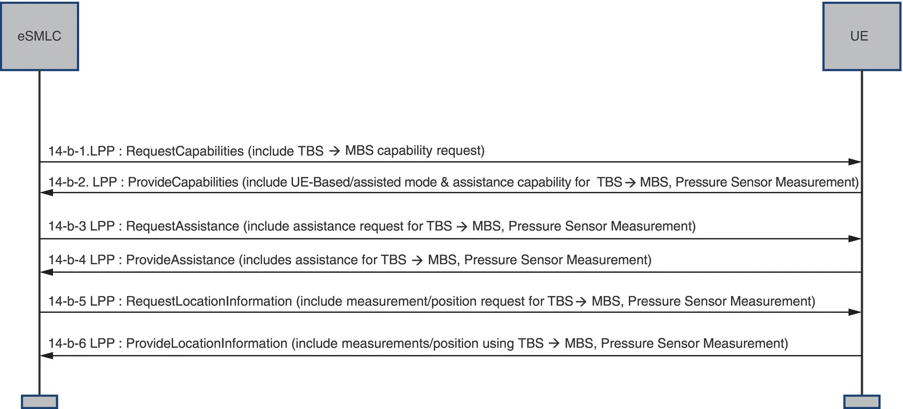
Figure 39.20 LPP call flow for MBS positioning using assistance.
Corresponding standards work has been done in OMA for MBS positioning in the data plane. Mobile Location Protocol MLP version 3.5 [20] includes support for indicating the use of the MBS positioning solution, the barometric pressure sensor solution, as well as hybrids thereof from the Location Server to the Mobile Location System MLS client (e.g. UE), while SUPL version 2.0.3 [21] includes support for the signaling of MBS capability.
39.1.8 Performance Results
The MBS system has been tested extensively in various urban/suburban environments in the San Francisco Bay Area and proved to be best in class in several blind independent tests held by the Communications Security, Reliability, Interoperability Council (CSRIC), an advisory body to the Federal Communications Commission (FCC), and by the Cellular Telecommunications and Internet Association (CTIA)/Alliance For Telecommunications Industry Solutions (ATIS).
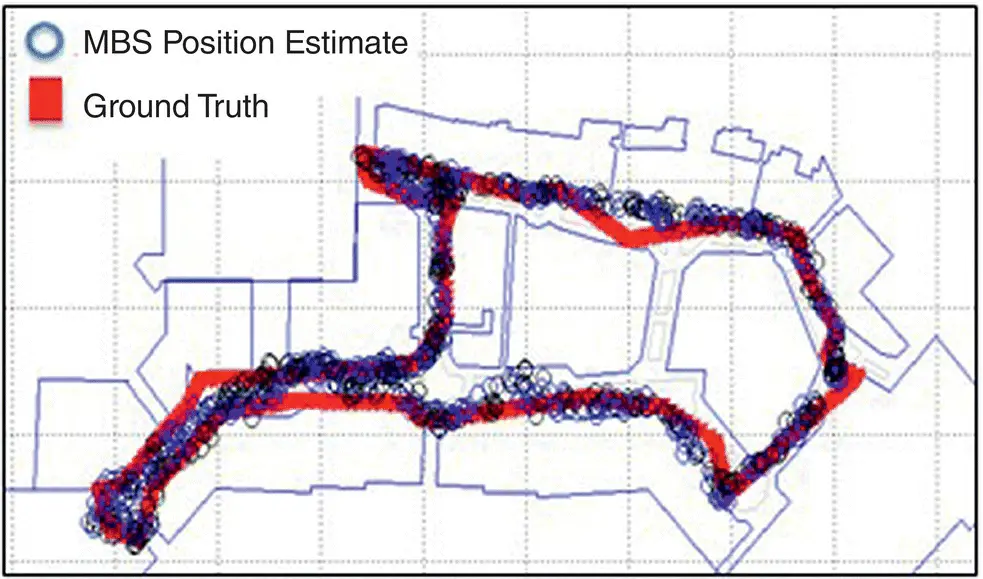
Figure 39.21 Representative 2D accuracy walk test result.
A sample 2D performance walk test result from a mall in the San Francisco Bay Area is shown in Figure 39.21using only MBS signals. The results are shown in ENU coordinates with the x ‐ and y ‐axis representing the east and north displacement in meters. The red markers indicate the position truth and the blue circle markers indicate the position estimates using MBS measurements only. The results show sub‐10‐m 2D error performance.
A sample z ‐axis test result from a hotel in the San Francisco Bay Area is shown in Figure 39.22. The truth position is shown in dashed red lines, and the MBS estimated altitude is shown in black. The results show altitude estimates within a floor throughout this test.
A sample result from an outdoor drive test in a small campus‐wide MBS network is shown in Figure 39.23. The black path shows the position truth path, and the blue path colors show the estimated position from the MBS. In this test, position estimates are computed using the MBS beacon measurements only. The results show that the 2D error was less that 10 m a majority of the time.
39.1.9 Conclusion
As we move from a world which is driven by human intelligence to a world driven by machine intelligence, the need for more reliable and pervasive 3D geolocation becomes critical. GPS is a critical enabler of this machine‐driven world; however, it has also become clear that it has severe limitations indoors and in urban areas where the laws of physics cannot be extended further, and the GPS system needs to be augmented in order to satisfy all the applications that this world requires. The Metropolitan Beacon System represents this new class of augmentation techniques and is designed to be the lowest‐cost, most scalable technology that delivers highly reliable PNT across its footprint.
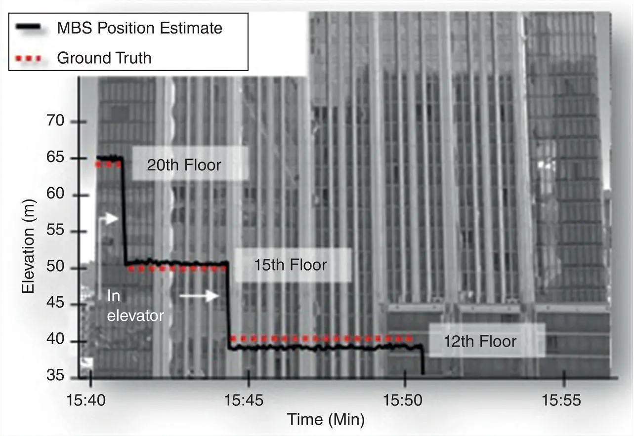
Figure 39.22 Representative z‐axis walk test result at a multi‐storied hotel.
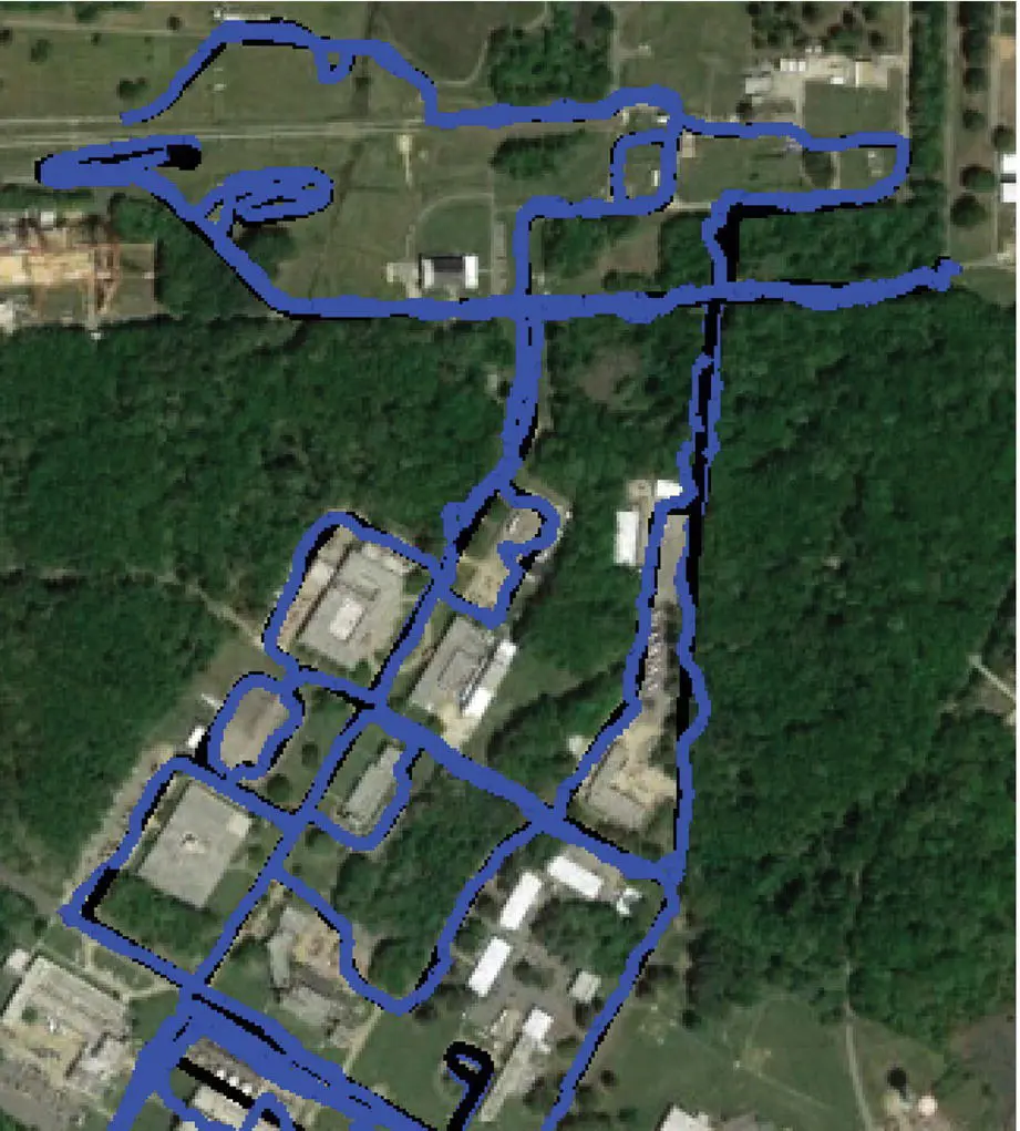
Figure 39.23 The KML snapshot shows the 2D error performance.
The technology has been standardized in global telecommunication standards such as 3GPP/OMA, the spectrum in the United States has been perfected for multi‐lateration purposes, and the technology has been licensed by Tier 1 chipset and server providers and demonstrated to be best in class. It is on the cusp of commercial availability, enabling a host of new applications around Mobile, 5G, Internet of Things, and driverless cars and drones.
References
1 1 Global Positioning Systems Directorate System Engineering and Integration Interface Specification, GPS‐IS‐200F, September 2012.
2 2 GLONASS Interface Control Document, Navigational Signal in L1 and L2, Edition 5.1, Moscow 2008.
3 3 BeiDou Navigation Satellite System, Signal In Space Interface Control Document, Open Service Signal B1I (Version 1.0), December 2012.
4 4 European GNSS (Galileo) Open Service Signal‐In‐Space Interface Control Document, Issue 1.3, December 2016.
5 5 Chun Yang, Chapter 35: Navigation with terrestrial digital broadcast signals, Position, Navigation, and Timing Technologies in the 21st Century, Vol. 2.
6 6 Federal Communications Commission (FCC), FCC Rules Part 90, Sub Part M Intelligent Transportation Systems Radio Service, Section 90.353 and 90.357.
7 7 Federal Communications Commission (FCC), FCC Rules Part 90, Sub Part I General Technical Standards, Section 90.205 and 90.210.
8 8 ATIS, MBS ICD Version G1.0. Available upon request by e‐mail from ATIS Document Center doccenter@atis.orgwith subject “Request for Metropolitan Beacon System (MBS) ICD.”
9 9 J.G. Proakis and M. Salehi, Digital Communications, Chapter 9.2, Mc‐Graw Hill, 2008.
10 10 F. Van Diggelen, A‐GPS: Assisted GPS, GNSS, and SBAS, Artech House, 2009.
11 11 Microsemi Whitepaper, https://www.microsemi.com/document‐portal/doc_view/133469‐synchronization‐distribution‐architectures‐for‐lte‐networks.
12 12 M. Weiss, Telecom Requirements for Time and Frequency Synchronization, https://www.gps.gov/cgsic/meetings/2012/weiss1.pdf.
13 13 ITU G.8271.1, Time and Phase Synchronization Aspects of Telecommunication Networks.
14 14 3GPP, LTE Positioning Protocol (LPP), Release 13, 3GPP TS 36.355 V13.3.0 (2016‐12).
15 15 3GPP, User Equipment (UE) Performance Requirements for RAT‐Independent Positioning Enhancements, Release 13, 3GPP TS 37.171 V13.1.0 (2016‐12).
16 16 3GPP, User Equipment (UE) Conformance Specification for UE positioning Part 1, Release 13, 37.571‐1 V13.3.0 (2017‐03).
17 17 3GPP, LTE Positioning Protocol (LPP), Release 14, 3GPP TS 36.355 V14.2.0 (2017‐06).
18 18 3GPP, User Equipment (UE) Performance Requirements for RAT‐Independent Positioning Enhancements, Release 14, 3GPP TS 37.171 V14.2.0 (2017‐06).
19 19 3GPP, User Equipment (UE) Conformance Specification for UE positioning Part 1, Release 14, 37.571‐1 V14.2.0 (2017‐06).
20 20 Open Mobile Alliance (OMA), Mobile Location Protocol, Draft Version 3.5 – 26 January 2016.
Читать дальшеИнтервал:
Закладка:
Похожие книги на «Position, Navigation, and Timing Technologies in the 21st Century»
Представляем Вашему вниманию похожие книги на «Position, Navigation, and Timing Technologies in the 21st Century» списком для выбора. Мы отобрали схожую по названию и смыслу литературу в надежде предоставить читателям больше вариантов отыскать новые, интересные, ещё непрочитанные произведения.


Обсуждение, отзывы о книге «Position, Navigation, and Timing Technologies in the 21st Century» и просто собственные мнения читателей. Оставьте ваши комментарии, напишите, что Вы думаете о произведении, его смысле или главных героях. Укажите что конкретно понравилось, а что нет, и почему Вы так считаете.