John D. Cox - Weather For Dummies
Здесь есть возможность читать онлайн «John D. Cox - Weather For Dummies» — ознакомительный отрывок электронной книги совершенно бесплатно, а после прочтения отрывка купить полную версию. В некоторых случаях можно слушать аудио, скачать через торрент в формате fb2 и присутствует краткое содержание. Жанр: unrecognised, на английском языке. Описание произведения, (предисловие) а так же отзывы посетителей доступны на портале библиотеки ЛибКат.

- Название:Weather For Dummies
- Автор:
- Жанр:
- Год:неизвестен
- ISBN:нет данных
- Рейтинг книги:5 / 5. Голосов: 1
-
Избранное:Добавить в избранное
- Отзывы:
-
Ваша оценка:
Weather For Dummies: краткое содержание, описание и аннотация
Предлагаем к чтению аннотацию, описание, краткое содержание или предисловие (зависит от того, что написал сам автор книги «Weather For Dummies»). Если вы не нашли необходимую информацию о книге — напишите в комментариях, мы постараемся отыскать её.
is your resource to fuel your curiosity about the weather. It takes you on an exciting journey through the Earth's atmosphere and the ways it behaves. You’ll get an overview of rain, Sun, clouds, storms and other phenomena.
With helpful photographs and illustrations, you can easily visualize different weather types and relate them into the world around you. The scientific words and phrases are explained in detail (what is barometric pressure?), your curious questions are answered (why do we have seasons?), and the roots of weather myths, proverbs, and sayings are revealed (“early thunder, early spring”).
Discover how weather forecasts are made, and what constitutes a weather emergency Find out what causes change in weather, such as how air pressure drives winds Learn how climate change is affecting today’s weather Discover how light plays tricks on our eyes to create effects like rainbows, sun dogs, and halos Have fun with at-home weather experiments, including setting up your own weather station Perfect for any weather amateur, you can have your head in the clouds while your feet are on the ground. Next time you’re outside, take
along with you, look at the sky, and discover something new about the environment you live in.
Weather For Dummies — читать онлайн ознакомительный отрывок
Ниже представлен текст книги, разбитый по страницам. Система сохранения места последней прочитанной страницы, позволяет с удобством читать онлайн бесплатно книгу «Weather For Dummies», без необходимости каждый раз заново искать на чём Вы остановились. Поставьте закладку, и сможете в любой момент перейти на страницу, на которой закончили чтение.
Интервал:
Закладка:
Summer air masses
The continental polar air that brought frigid misery during winter often has a welcome cooling effect over much of the United States in summer. Fair weather generally prevails over the Northern Plains and Midwest when continental polar air is around, occasionally reaching even the Gulf of Mexico with pleasant dry air.
Maritime tropical air masses from the Atlantic Ocean, the Caribbean Sea, and the Gulf of Mexico spend a lot of time over the eastern two-thirds of the United States during summer, especially the Southeast, bringing warm temperatures and high humidity.
Continental tropical air forms over the big desert regions of northern Mexico and the U.S. Southwest in summer, keeping things hot and dry.
News from the Fronts
During the most powerful storms of winter and summer you will probably find two air masses of very different qualities — different temperatures and humidities — crashing into one another. When upper winds and other conditions are right, this is where you will see a powerful mid-latitude cyclone with well-defined fronts that bring rain or snow over big sections of the country. In spring and summer, along these fronts can be long lines of severe thunderstorms that can form tornadoes when conditions are right — or wrong!
It might look like a rainy or snowy mess from down below, but a front, the transition zone or line between two distinct air masses, has a certain shape or structure to it, depending on what’s going on.
Cold fronts
When a cold front moves into space occupied by warmer air, it forces the warmer air to rise up and over the leading cold wedge. This is because cold air is denser, or heavier, than warm air and sort of bullies it out of the way. As the warm air rises, it mixes with the cold air and condenses into big clouds. Figure 3-3 shows what happens with the passage of a typical cold front.
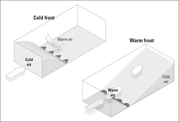
FIGURE 3-3:These diagrams illustrate what usually happens when cold fronts and warm fronts come along.
Often, these cold fronts are carried along by westerly winds, which tear away the tops of these clouds and carry them out far in advance of the approaching front. The first sign of an advancing cold front can be the appearance of these high clouds, followed quickly by a thickening sky. And then a line of heavy thundershowers develops as the front passes, followed by steadier and gradually lighter rain. A typical cold front moves about 30 miles an hour, often traveling to the south and east.
Warm fronts
When a warm front moves into the space occupied by a retreating cold air mass, it develops a completely different precipitation pattern than an advancing cold front would. While a cold front digs in underneath a warm air mass, because its air is denser, the lighter air of a warm front rides up above the cold air it is replacing. In this rising warm air, clouds form far out ahead of the advancing warm front’s boundary. Hundreds of miles ahead of the surface edge of a warm front, the cloud cover slowly thickens, finally bringing rain or snow. All this happens long before the surface edge of the warm front finally passes. When that happens, the sky is usually clear. A typical warm front can travel about 10 to 20 miles per hour, most often moving north and east.
THERE GOES THE MOON
Sailors and poets and ancient thinkers all favored the idea that the moon has a lot to do with how things go here on Earth. A “ring around the moon” was seen as a sign of impending storminess, for example, but none of it is the moon’s doing.
That ring or halo is moonlight — sunshine reflecting off of the moon’s surface — scattering as it encounters thin clouds in the atmosphere. They might be high in the atmosphere, those clouds, but they are nowhere near the moon.
But the moon has this important indirect impact on weather: The tug of its gravity makes the tides of oceans and very large lakes rise and fall, and during powerful coastal storms, high tides can make the difference between inconvenience and natural disaster.
Stationary fronts
A stationary front, as you might expect, isn’t going anywhere, at least for the time being. But don’t let its lack of motion fool you. A stationary or slow-moving front can mean real trouble. A lot of weather can be happening around a front that isn’t moving. Sometimes, when warm humid air travels over the frontal boundary, rainfall can occur over large areas, and because the front isn’t moving, the rain may stay long enough to cause flooding.
Occluded fronts
As a winter storm progresses, the large wedge of warmer air between the warm front and the cold front gets narrower. The cold front travels faster than the warm front, and beginning near the low-pressure center of a mature storm, it eventually overtakes it. This new boundary is called an occluded front. On one side is cold air from behind the cold front. On the other is cool air that the warm front was flowing over. Above the front is warm air that has been cut off from the ground.
Here Comes the Sun
 Weather is the Sun’s doing. It might be hard to believe when you are being hammered by a cold winter storm, but the Sun, the star of the solar system, is the driving force behind all this weather, the commander in chief of all these air wars. The heat energy — the solar energy — radiating from this star is the fuel that drives it all, everything I describe in Weather For Dummies. If it were not for the Sun’s warming of Earth and its atmosphere, the planet would be frozen solid, a ball of ice. (And nobody would be around to read — or write — about the weather.) The Sun’s energy is the fuel, and weather is the result of the huge temperature differences between the Equator and the poles. These temperature differences are partly Earth’s doing, of course. But if you want something to blame it on, blame the weather on what happens deep within the interior of a star 93 million miles away!
Moving Sun’s energy
The atmosphere is always in the process of converting the Sun’s energy from one form to another and moving it from place to place. Behind all the motion, and commotion, is a complicated exchange of energy between the atmosphere and the Earth. Things are out of balance, and the system is trying to even them out. Weather is the name we give to the atmosphere’s turbulent efforts to balance the cold with the hot, the dry with the wet. The atmosphere deflects more of the Sun’s radiation than it absorbs, and Earth’s surface has a solar energy surplus. This exchange process is what keeps the atmosphere from becoming unbearably cold and the ground you and I stand on from getting unbearably hot.
 Through heat-transfer processes that weather scientists call conduction and convection, the radiation surplus is continually moving from the surface up into the atmosphere. The heat is conducted directly from the surface to the thin layer of atmosphere above it. You might say that the convection process takes it from there, mixing it through winds and other weather processes among the higher layers of atmosphere.
Интервал:
Закладка:
Похожие книги на «Weather For Dummies»
Представляем Вашему вниманию похожие книги на «Weather For Dummies» списком для выбора. Мы отобрали схожую по названию и смыслу литературу в надежде предоставить читателям больше вариантов отыскать новые, интересные, ещё непрочитанные произведения.


Обсуждение, отзывы о книге «Weather For Dummies» и просто собственные мнения читателей. Оставьте ваши комментарии, напишите, что Вы думаете о произведении, его смысле или главных героях. Укажите что конкретно понравилось, а что нет, и почему Вы так считаете.