Sylvain Pioch - Eco-design of Marine Infrastructures
Здесь есть возможность читать онлайн «Sylvain Pioch - Eco-design of Marine Infrastructures» — ознакомительный отрывок электронной книги совершенно бесплатно, а после прочтения отрывка купить полную версию. В некоторых случаях можно слушать аудио, скачать через торрент в формате fb2 и присутствует краткое содержание. Жанр: unrecognised, на английском языке. Описание произведения, (предисловие) а так же отзывы посетителей доступны на портале библиотеки ЛибКат.
- Название:Eco-design of Marine Infrastructures
- Автор:
- Жанр:
- Год:неизвестен
- ISBN:нет данных
- Рейтинг книги:5 / 5. Голосов: 1
-
Избранное:Добавить в избранное
- Отзывы:
-
Ваша оценка:
Eco-design of Marine Infrastructures: краткое содержание, описание и аннотация
Предлагаем к чтению аннотацию, описание, краткое содержание или предисловие (зависит от того, что написал сам автор книги «Eco-design of Marine Infrastructures»). Если вы не нашли необходимую информацию о книге — напишите в комментариях, мы постараемся отыскать её.
Eco-design of Marine Infrastructures — читать онлайн ознакомительный отрывок
Ниже представлен текст книги, разбитый по страницам. Система сохранения места последней прочитанной страницы, позволяет с удобством читать онлайн бесплатно книгу «Eco-design of Marine Infrastructures», без необходимости каждый раз заново искать на чём Вы остановились. Поставьте закладку, и сможете в любой момент перейти на страницу, на которой закончили чтение.
Интервал:
Закладка:
– the file is the document that explains, in particular for the attention of the examining body that issues the authorization and for the attention of the public, the way in which the project owner has taken the environment into account throughout the design of their project and the measures to which they commit themself to mitigate its impacts.
Regulatory reinforcement now requires a new vision of the development project, not only socio-technical-economic but also ecological, in order to minimize (cancel?) the negative impacts.
These requirements are constantly being reinforced. Even though the controls on the ground are still too weak, it is undeniable that the application of the regulatory framework aiming at a “no net loss of biodiversity” will reinforce the interest towards constructions with a reduced effect on the environment, or even positive ones.
However, a development project exists in response to a functional need that requires a technical response: (i) the function of a breakwater is to protect a port and is adapted to the hydrodynamic actions of the place; (ii) a quay is there to allow the berthing, mooring and loading/unloading of ships and is adapted to the project ship and the transported goods.
This idea should not replace a deleterious business as usual from human activities damaging to the environment, thanks to green washing (fake eco-design) that allows future construction. It is very important to underline here that this approach is to be carried out in parallel with the ARO approach in the impact study.
Therefore, before any integration of the environment into a technical design, it is absolutely necessary to perfectly master the latter. A certain technical virtuosity is required to propose daring technical variants necessary to take the environment into account in the eco-design process.
This is the objective of Chapter 2, which will present a brief review of the technical concepts related to marine structures and the skills that the marine engineer must have.
1.6. Specificities of the environmental assessment related to the marine environment: the “natural” public maritime domain concept
1.6.1. The natural public maritime domain, an essential concept
An important specificity of an eco-design approach in the marine environment is the legal framework attached to it as public property. The natural public maritime domain (nPMD) 20refers to this remarkable, sensitive and coveted space at the interface of land and sea ( Figure 1.7).
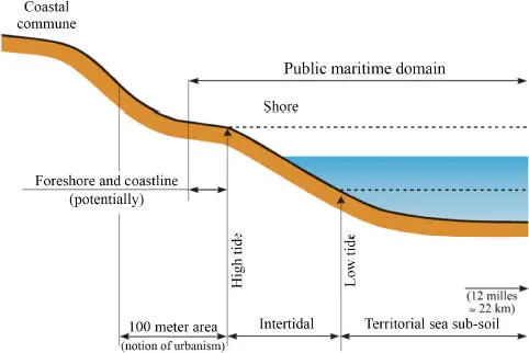
Figure 1.7. The extent of the natural public maritime domain in France (Article L. 2111-4 of the CGPPP). For a color version of this figure, see www.iste.co.uk/pioch/marine.zip
In France, reflections on its status as a “natural” space are long-standing, dating back to the Edict of Moulins (1566) and to Colbert’s ordinances on the Navy (article 1 of title VII of book IV of the ordinance of August 1681): “The edge and shore of the sea will be considered to be all that it covers and uncovers during the new and full moons, and as far as the great flood of March can extend over the shores.”
This “natural” territorial zoning has been confirmed by jurisprudence, in particular the French Council of State decision which specifies “the limit of the nPMD at the point of the highest seas […] in the absence of exceptional disturbances” (Kreitmann decision of October 12, 1973).
The nPMD cannot be the object of private appropriation. The marine environment is therefore considered as res nullius , belonging to no one, without master or owner, but which can be appropriated in the context of uses (fishing, exploitation of aggregates, energy production, etc.), and its resources res communis , belonging to all citizens, therefore accessible and usable by all.
At the global level, this principle, and the resulting jurisdictional divisions, are a constant in all coastal states (Féral 2011). The roots of this conception of the marine environment can be found in the marine code of Eleanor of Aquitaine (12th century), followed by the claim of the Dutchman Hugo Grotius in 1609, for a mare liberum linked to the objective of free trade at sea. Only the coasts were subject to a special provision for the allocation of their resources and the protection of state borders.
The sovereign power of a coastal state extended pragmatically to what could be defended, that is, 3 nautical miles (1 nm = 1.8 km), or roughly the range of a cannon shot, from the coast. The 1982 Montego Bay Convention (UNCLOS) modified this conception of a sea as a “public asset”.
With the exception of this narrow strip of 3 nautical miles, the rest of the maritime continent was a “free” or lawless zone until the last 30 years. From then on, the “territorial seas” were extended to 12 nm (about 22 km) from the coast, with a contiguous zone of 22 nm where only the right of prosecution of states is exercised, within the framework of customs operations (drugs, human trafficking, etc.). The UNCLOS developed the idea of exclusive economic zones (EEZs 21) that reach up to 200 nm from the coastline ( Figure 1.8). In the EEZs, states do not exercise formal sovereignty but have the sole right to exploit resources (fisheries and fossils) from the surface of the ocean to the seabed and its subsoil.
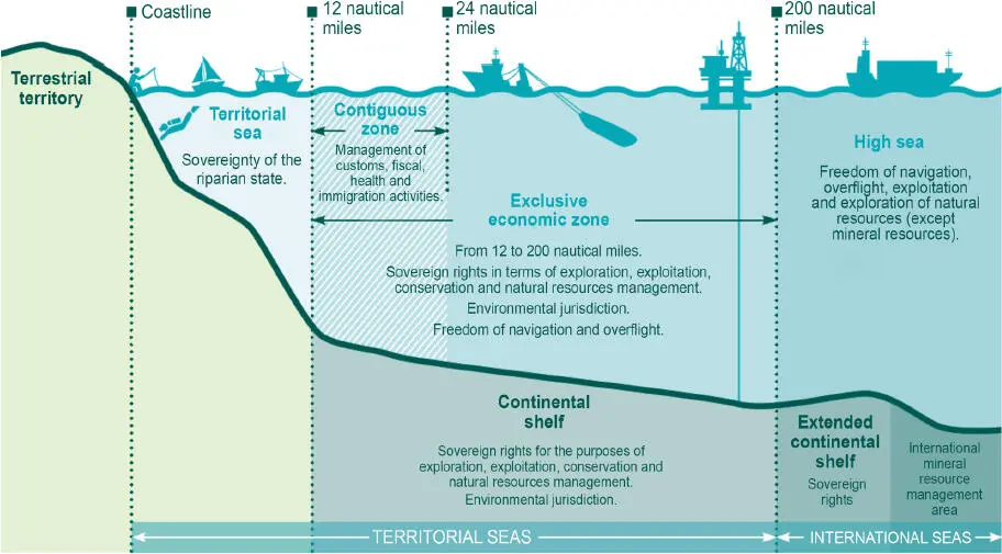
Figure 1.8. Maritime boundaries and spaces of coastal state jurisdiction (MEB 2016). For a color version of this figure, see www.iste.co.uk/pioch/marine.zip
In addition, states may request the extension of their EEZ to a maximum distance of 350 nautical miles, depending on the geomorphology of their continental shelf (geological continuity extension). However, the principle of free access, of mare liberum , always prevails beyond EEZs on the high seas. It is a free commodity that belongs to no one, does not fall under the sovereignty of any state and is not subject to any appropriation regime, nor to governance ( res nullius ). The threats to fish stocks are therefore still very real. In contrast, it is within the framework of the UNCLOS that a new notable status was established for the sea, that of a World Heritage Site. The founding act of this idea was the speech made in 1967 by Arvid Pardo, Maltese Ambassador to the United Nations (UN 1967, 22nd session, meeting 1515). He was the first to defend the idea that the seabed and its subsoil should be defined as a world heritage site: a space of goods belonging to all humanity and, therefore, removed from the exclusive appropriation of states.
The principle was confirmed by Declaration 2749 (XXV), adopted by the United Nations General Assembly in 1970, and then definitively endorsed in the 1982 Montego Bay International Convention on the Law of the Sea, which created a special legal regime applicable to the seabed and its subsoil beyond the EEZ. In this part of the sea, called the “zone” ( Figure 1.8), states or industrialists are allowed to explore or exploit mineral resources upon approval by the International Seabed Authority. However, at the same time, the mechanism proposed that an organization called “The Enterprise” (never defined) would exploit the same quantities as the industrialists (another principle of equivalence), but for the benefit of developing countries. A beautiful vision, but which in fact has not yet given rise to any “repayment” of the exploitation of this immense area, for the development aid of the planet, by an exploiting industrialist. Technical problems or timid philanthropism?
Читать дальшеИнтервал:
Закладка:
Похожие книги на «Eco-design of Marine Infrastructures»
Представляем Вашему вниманию похожие книги на «Eco-design of Marine Infrastructures» списком для выбора. Мы отобрали схожую по названию и смыслу литературу в надежде предоставить читателям больше вариантов отыскать новые, интересные, ещё непрочитанные произведения.


Обсуждение, отзывы о книге «Eco-design of Marine Infrastructures» и просто собственные мнения читателей. Оставьте ваши комментарии, напишите, что Вы думаете о произведении, его смысле или главных героях. Укажите что конкретно понравилось, а что нет, и почему Вы так считаете.