Jerry T. Mitchell - Geography For Dummies
Здесь есть возможность читать онлайн «Jerry T. Mitchell - Geography For Dummies» — ознакомительный отрывок электронной книги совершенно бесплатно, а после прочтения отрывка купить полную версию. В некоторых случаях можно слушать аудио, скачать через торрент в формате fb2 и присутствует краткое содержание. Жанр: unrecognised, на английском языке. Описание произведения, (предисловие) а так же отзывы посетителей доступны на портале библиотеки ЛибКат.
- Название:Geography For Dummies
- Автор:
- Жанр:
- Год:неизвестен
- ISBN:нет данных
- Рейтинг книги:5 / 5. Голосов: 1
-
Избранное:Добавить в избранное
- Отзывы:
-
Ваша оценка:
Geography For Dummies: краткое содержание, описание и аннотация
Предлагаем к чтению аннотацию, описание, краткое содержание или предисловие (зависит от того, что написал сам автор книги «Geography For Dummies»). Если вы не нашли необходимую информацию о книге — напишите в комментариях, мы постараемся отыскать её.
Geography For Dummies
Geography For Dummies
Geography For Dummies — читать онлайн ознакомительный отрывок
Ниже представлен текст книги, разбитый по страницам. Система сохранения места последней прочитанной страницы, позволяет с удобством читать онлайн бесплатно книгу «Geography For Dummies», без необходимости каждый раз заново искать на чём Вы остановились. Поставьте закладку, и сможете в любой момент перейти на страницу, на которой закончили чтение.
Интервал:
Закладка:
Latitude
 The system of latitude lines has the following characteristics:
Lines of latitude run across the map (east-west) and are called parallels because each line of latitude is parallel to every other line of latitude.
The equator (Latitude 0°) divides the world into the Northern Hemisphere and the Southern Hemisphere. WHY IS EARTH 360° ROUND?The ancient Sumerians believed there were 360 days in a year. Like other civilizations way back when, the Sumerians equated their gods with celestial objects. Not surprisingly, the sun god was especially important. Because it took the Earth 360 days to travel around the sun (or so they believed), the Sumerians figured the number 360 had extra-special significance. As a result, they developed a system of mathematics based on multiples of 6 and 60. Nowadays, we would call it base-6 mathematics or (get ready for this) a sexagesimal system. In any event, 6 times 60 equals 360.The ancient Egyptians adopted the ancient Sumerians’ numerical ideas, and eventually discovered the error concerning the length of the year. But by then, however, the number 360 had achieved such acceptance and status that the Egyptians decided not to mess with it. Accordingly, they kept the 360-day year but, being fun-loving people, added an annual 5-day holiday.The ancient Greeks, like the ancient Egyptians, were adept at adopting things and ideas from civilizations more ancient than they. So, when Hipparchus, in about 140 B.C., began fiddling with the notion of dividing a circle (and Earth) into degrees, he chose the number 360.
Starting from the equator, each successive line (degree) of latitude is numbered consecutively both to the north and to the south as far as the North Pole (Latitude 90° North) and South Pole (Latitude 90° South).
Except for the equator, each line of latitude is identified by a number between 0 and 90 and by the word North or South (or the abbreviations N or S) to indicate its location north or south of the equator. Thus, the line that is 20 degrees north of the equator is referred to as Latitude 20° North (or 20° North Latitude). It would be misleading and incomplete to just call this line “Latitude 20” because another line of latitude south of the equator could also be called “Latitude 20.”
Only one line of latitude — the equator — is a great circle, a line that divides Earth in half.
WHAT’S WRONG WITH THIS MAP?
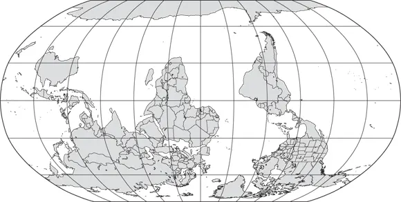
(© John Wiley & Sons Inc.)
The answer to the headline is this: Nothing much, really. You could say the map is upside down, and you would be right to a point. After all, nowadays maps commonly have north at the top. But considered as a planet in the multi-dimensional vastness of space, Earth has no “right side up.” Thus, no compelling scientific reason exists as to why you can’t make a map with south toward the top — other than that it would look strange and confusing to most people. Indeed, in olden times maps were oriented every which way. Chinese maps tended to have south at the top, and early Christian maps had east on top with Jerusalem at the center.
Suffice to say, there are a number of competing ideas about how north got on top. The discovery of magnetic north? The preference of ninth-century Frankish emperor Charlemagne, who as powerful king would have held a bit of sway? The widespread use of the Mercator projection by navigators (see Chapter 4to find out more about this)?
Regardless of how it came about, north at the top tends to be the default, but there are exceptions. If you have a bit of free time, go online and search for Chile’s Directorate General of Civil Aviation. Their logo includes a map that bucks convention.
Longitude
The system of longitude lines has the following characteristics:
Lines of longitude run from the North Pole to the South Pole (top to bottom of the map) and are called meridians.
As opposed to latitude, no two lines of longitude are parallel to each other. Rather, successive lines of longitude are about 70 miles apart at the equator, but from there they slowly converge until they come together at the two poles (see Figure 3-2).
The prime meridian (Longitude 0°) divides the world into the Eastern Hemisphere and the Western Hemisphere.
Starting from the prime meridian, every line (degree) of longitude is numbered consecutively to the east and to the west half way around the world. Because Earth is 360 degrees around, 180 degrees of longitude lie east and west of the prime meridian.
Every line of longitude (except the prime meridian and the 180-degree line) is identified by a number from 1 to 179, and by the words East or West (or the letters E or W) to indicate its location east or west of the prime meridian. Thus, the line that is 20 degrees east of the prime meridian is referred to as Longitude 20° East. It would be misleading to call this line “Longitude 20” because some another line that is 20 degrees west of the prime meridian also could be called “Longitude 20.”
Every line of longitude is a great circle — a line which, if continued around the world, would divide Earth equally in half.
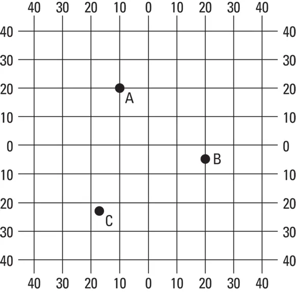
Graticule
 As far as geographers are concerned, latitude and longitude make for a very special grid that deserves a special name, the graticule, to distinguish it from every other kind of grid. Indeed, this name is so special that many dictionaries and computer spell-check programs do not recognize it. But geographers do, and they are extremely impressed if they hear it used by a layperson.
But more important than saying “graticule” is the ability to use it properly. That means, among other things, correctly identifying the grid coordinates (latitude and longitude) of locations indicated on a map. With that in mind, take a look at Figure 3-3, which represents a portion of the graticule. Note that lines of longitude are shown parallel (when in reality they converge toward the poles) and that only every tenth degree-line of latitude and longitude are indicated. World maps typically “skip” lines in a similar fashion, lest they become cluttered by the graticule. But what I really want you to focus on are the three dots lettered A, B, and C. See if you correctly can identify the coordinates of each dot, keeping in mind the following rules:
1 When reporting coordinate locations, always give the latitude first, and then give the longitude. (Why? Because latitude comes first alphabetically? Because latitude was accurately measured before longitude? It doesn’t really matter. It’s just the rule and the system only works if everyone uses it the same way.)
2 Correct reference to latitude must specify whether a location is north or south of the equator (Latitude 0°), assuming the location is not on the equator itself.
3 Correct reference to longitude must specify whether a location is east or west of the Prime Meridian (Longitude 0°).
(© John Wiley & Sons Inc.)
Читать дальшеИнтервал:
Закладка:
Похожие книги на «Geography For Dummies»
Представляем Вашему вниманию похожие книги на «Geography For Dummies» списком для выбора. Мы отобрали схожую по названию и смыслу литературу в надежде предоставить читателям больше вариантов отыскать новые, интересные, ещё непрочитанные произведения.


Обсуждение, отзывы о книге «Geography For Dummies» и просто собственные мнения читателей. Оставьте ваши комментарии, напишите, что Вы думаете о произведении, его смысле или главных героях. Укажите что конкретно понравилось, а что нет, и почему Вы так считаете.