Geophysical Monitoring for Geologic Carbon Storage
Здесь есть возможность читать онлайн «Geophysical Monitoring for Geologic Carbon Storage» — ознакомительный отрывок электронной книги совершенно бесплатно, а после прочтения отрывка купить полную версию. В некоторых случаях можно слушать аудио, скачать через торрент в формате fb2 и присутствует краткое содержание. Жанр: unrecognised, на английском языке. Описание произведения, (предисловие) а так же отзывы посетителей доступны на портале библиотеки ЛибКат.

- Название:Geophysical Monitoring for Geologic Carbon Storage
- Автор:
- Жанр:
- Год:неизвестен
- ISBN:нет данных
- Рейтинг книги:4 / 5. Голосов: 1
-
Избранное:Добавить в избранное
- Отзывы:
-
Ваша оценка:
Geophysical Monitoring for Geologic Carbon Storage: краткое содержание, описание и аннотация
Предлагаем к чтению аннотацию, описание, краткое содержание или предисловие (зависит от того, что написал сам автор книги «Geophysical Monitoring for Geologic Carbon Storage»). Если вы не нашли необходимую информацию о книге — напишите в комментариях, мы постараемся отыскать её.
Geophysical Monitoring for Geologic Carbon Storage
Volume highlights include: Geophysical Monitoring for Geologic Carbon Storage
The American Geophysical Union promotes discovery in Earth and space science for the benefit of humanity. Its publications disseminate scientific knowledge and provide resources for researchers, students, and professionals.
Geophysical Monitoring for Geologic Carbon Storage — читать онлайн ознакомительный отрывок
Ниже представлен текст книги, разбитый по страницам. Система сохранения места последней прочитанной страницы, позволяет с удобством читать онлайн бесплатно книгу «Geophysical Monitoring for Geologic Carbon Storage», без необходимости каждый раз заново искать на чём Вы остановились. Поставьте закладку, и сможете в любой момент перейти на страницу, на которой закончили чтение.
Интервал:
Закладка:
Another difficulty is introduced by the seasonal and atmospheric conditions, including long periods of snow cover in this part of the world. Some permanent scatterers such as steep roofs and tall towers may not accumulate much snow, but large areas will be covered, reducing the coherence and introducing significant variations to the characteristics of the scattering surface. Artificial reflectors, man‐made, stable targets designed to remain free of snow, are one remedy and are commonly used in areas prone to snowfall. In order to provide for year‐round coverage, 21 artificial reflectors, spaced 75 m apart, were constructed and emplaced in an open area close to the injection well‐pad ( Fig. 2.13). All 21 reflectors were found to have strong and stable reflectivity, both for ascending and descending satellite orbits.
The acquisition of COSMO‐SkyMed X‐band data began in July 2011, before the start of injection in November. Falorni et al. (2014) have reported on roughly 2 yr of observations from July 2011 until June 2013. They note that there is little or no ground motion associated with the start of injection with the exception of two points. For example, a time series consisting of the average range change from all 21 reflectors is plotted in Figure 2.14. The two points showing some movement correlating with the start of injection ( Fig . 2.15) were in the vicinity of the injection well and may reflect some movement related to the pressurization of the well bore itself.
The lack of injection‐related surface deformation is an expected result. Due to the high permeability and thickness of the reservoir sandstone, the bottom hole pressure has changed very little during the injection. Barring any unforeseen geologic features, such as an unmapped fracture zone, the carbon dioxide is expected to migrate outward into the reservoir without generating a large pressure change and associated deformation. The InSAR observations serve to verify the expected performance of the sequestration effort and to detect any deformation that may imply the upward movement of the carbon dioxide.
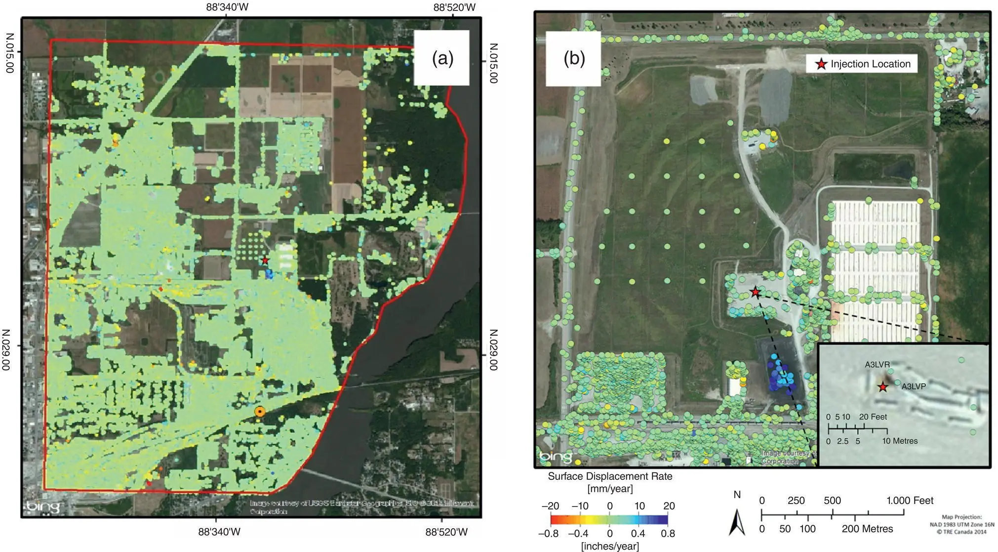
Figure 2.13 (a) Distribution of scatterers in the region surrounding the injection well (magenta star), roughly 4,000 per square kilometer. (b) Close‐up view of the region surrounding the injection well‐pad. The grid of artificial reflectors is visible to the northwest of the wellhead.
(From Monitoring the Deformation Associated with the Geological Storage of CO 2by Donald W. Vasco. Cambridge University Press. https://doi.org/10.1017/9781316480724.007.)
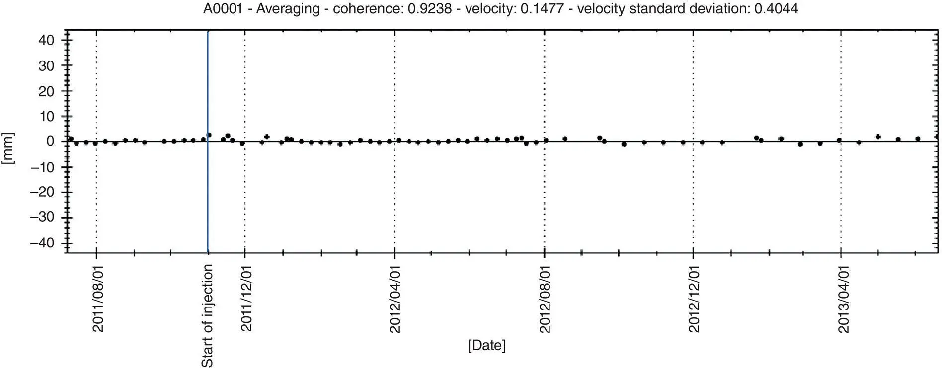
Figure 2.14 Average range change from the 21 artificial reflectors installed just to the northwest of the injection well site. The start of injection is indicated by the vertical blue line.
(From Falorni, G., Hsiao, V., Iannaconne, J., Morgan, J., & Michaud, J.‐S. (2014). InSAR monitoring of ground deformation at the Illinois Basin Decatur Project. In Carbon Dioxide Capture for Storage in Deep Geological Formations, Volume 4, CPL Press.)
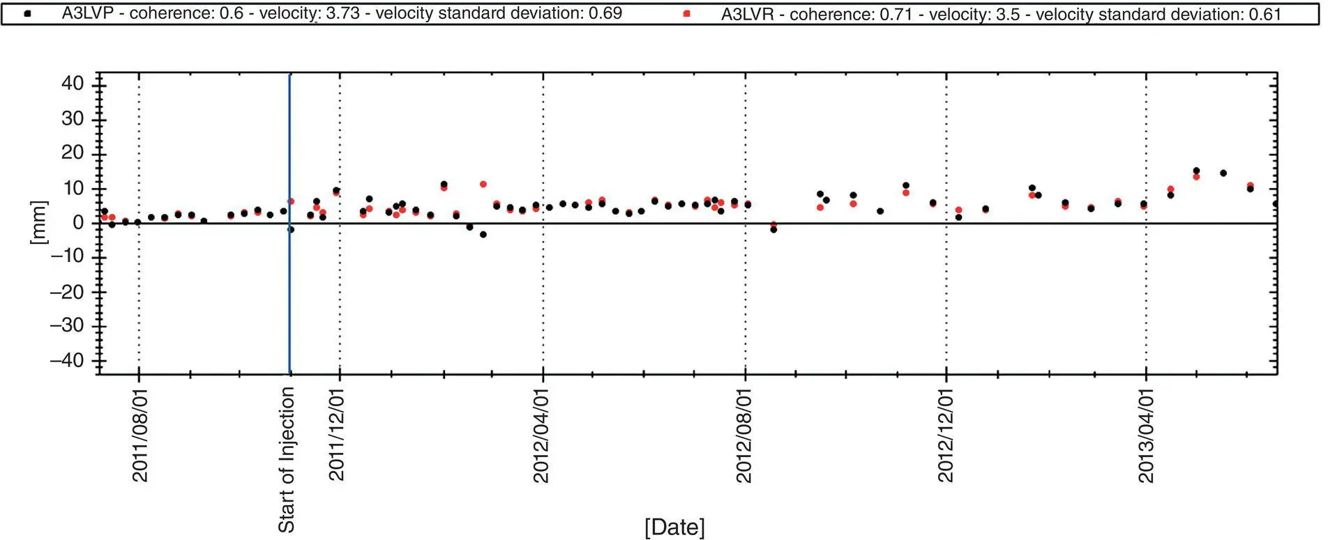
Figure 2.15 Time series of two measurement points in the vicinity of the injection well. The vertical blue line indicates the start of injection.
(From Falorni, G., Hsiao, V., Iannaconne, J., Morgan, J., & Michaud, J.‐S. (2014). InSAR monitoring of ground deformation at the Illinois Basin Decatur Project. In Carbon Dioxide Capture for Storage in Deep Geological Formations, Volume 4, CPL Press.)
2.5. CONCLUSIONS
Geodetic methods are well suited for monitoring the effectiveness of the geological storage of carbon dioxide. The application to carbon sequestration is still relatively new, but approaches such as Interferometric Synthetic Aperture Radar appear promising even at sites subject to periodic snow cover. Enhancements, such as artificial radar reflectors, may be required for certain difficult terrains such as farmed fields with intermittent snow cover. Even in these difficult areas, it appears possible to monitor ground deformation with the accuracy of 0.5 cm. In favorable regions such as desert regions with little movable sand, the accuracy can be of the order of a few millimeters. In an application at In Salah, Algeria, InSAR appears to be sensitive to focused flow in a narrow higher permeability damage zone, indicating deviations from pure reservoir flow. Other geodetic techniques, such as tilt meters, the Global Positioning System (GPS), and laser ranging (LiDAR) are also possible. Some methods, such as precision bathymetry and time‐lapse seismic strain measurements (Rickett et al., 2007) are applicable to storage in deformable offshore reservoirs.
ACKNOWLEDGMENTS
This work at Lawrence Berkeley National Laboratory was supported by the GEOSEQ project for the Assistant Secretary for Fossil Energy, Office of Coal and Power Systems, through the National Energy Technology Laboratory of the U. S. Department of Energy under contract DE‐AC02‐05‐CH11231. We would like to thank the Canadian Space Agency for providing RADARSAT‐2 data. The Petroleum Technology Research Centre provided logistical support for this work as well as project information. SaskPower provided access to the Aquistore site.
REFERENCES
1 Aki, K., & Richards, P. G. (1980). Quantitative seismology. W. H. Freeman and Company.
2 Bissell, R. C., Vasco, D. W., Atbi, M., Hamdani, M., Okwelegbe, M., & Goldwater, M. H. (2011). A full field simulation of In Salah Gas production and CO2 storage project using coupled geo‐mechanical and thermal fluid flow simulator. Energy Procedia, 4, 3290–3297.
3 Chawah, P., Chery, J. Boudin, F., Cattoen, M., Seat, H. C., Plantier, G., Lizion, F., et al. (2015). A simple pendulum borehole tiltmeter based on a triaxial optical‐fibre displacement sensor. Geophysical Journal International, 203, 1026–1038. https://doi.org/10.1093/gji/ggv358
4 Davis, P. M. (1983). Surface deformation associated with a dipping hydrofracture. Journal of Geophysical Research, 88, 5826–5834.
5 Eitel, J. J. H., Hofle, B., Vierling, L. A., Abellan, A., Asner, G. P., Deems, J. S, Glennie, C. L., et al. (2016). Beyond 3‐D: The new spectrum of lidar applications for Earth and ecological sciences. Remote Sensing of Environment, 186, 372–392.
6 Falorni, G, Hsiao, V., Iannaconne, J., Morgan, J., & Michaud, J.‐S. (2014). InSAR monitoring of ground deformation at the Illinois Basin Decatur Project. In Carbon dioxide capture for storage in deep geological formations, Vol. 4. CPL Press.
7 Ferretti, A. (2014). Satellite InSAR data: Reservoir monitoring from space. EAGE Publications.
8 Ferretti, A., Fumagalli, A., Novali, F., Prati, C., Rocca, F. & Rucci, A. (2011). A new algorithm for processing interferometric data‐stacks: SqueeSAR. IEEE Transactions on Geoscience and Remote Sensing, 49(9), 3460–3470.
9 Ferretti, A., Monti‐Guarnieri A., Prati, C., Rocca, F., & Massonnet, D. (2007a). InSAR principles: Guidelines for SAR interferometry processing and interpretation. ESA Publications, TM‐19. Available at: http://www.esa.int/About_Us/ESA_Publications
10 Ferretti, A., Prati, C. & Rocca, F. (2000). Nonlinear subsidence rate estimation using permanent scatterers in differential SAR interferometry. IEEE Transactions on Geoscience and Remote Sensing, 38(5), 2202–2212.
Читать дальшеИнтервал:
Закладка:
Похожие книги на «Geophysical Monitoring for Geologic Carbon Storage»
Представляем Вашему вниманию похожие книги на «Geophysical Monitoring for Geologic Carbon Storage» списком для выбора. Мы отобрали схожую по названию и смыслу литературу в надежде предоставить читателям больше вариантов отыскать новые, интересные, ещё непрочитанные произведения.


Обсуждение, отзывы о книге «Geophysical Monitoring for Geologic Carbon Storage» и просто собственные мнения читателей. Оставьте ваши комментарии, напишите, что Вы думаете о произведении, его смысле или главных героях. Укажите что конкретно понравилось, а что нет, и почему Вы так считаете.