Peter Friend - Southern England
Здесь есть возможность читать онлайн «Peter Friend - Southern England» — ознакомительный отрывок электронной книги совершенно бесплатно, а после прочтения отрывка купить полную версию. В некоторых случаях можно слушать аудио, скачать через торрент в формате fb2 и присутствует краткое содержание. Жанр: unrecognised, на английском языке. Описание произведения, (предисловие) а так же отзывы посетителей доступны на портале библиотеки ЛибКат.
- Название:Southern England
- Автор:
- Жанр:
- Год:неизвестен
- ISBN:нет данных
- Рейтинг книги:3 / 5. Голосов: 1
-
Избранное:Добавить в избранное
- Отзывы:
-
Ваша оценка:
Southern England: краткое содержание, описание и аннотация
Предлагаем к чтению аннотацию, описание, краткое содержание или предисловие (зависит от того, что написал сам автор книги «Southern England»). Если вы не нашли необходимую информацию о книге — напишите в комментариях, мы постараемся отыскать её.
Southern England — читать онлайн ознакомительный отрывок
Ниже представлен текст книги, разбитый по страницам. Система сохранения места последней прочитанной страницы, позволяет с удобством читать онлайн бесплатно книгу «Southern England», без необходимости каждый раз заново искать на чём Вы остановились. Поставьте закладку, и сможете в любой момент перейти на страницу, на которой закончили чтение.
Интервал:
Закладка:
Figures 29 and 32 also identify the different types of plate boundary, which are distinguished according to the relative motion between the two plates. Convergent plate boundaries involve movement of the plates from each side towards the suture (or central zone) of the boundary. Because the plates are moving towards each other, they become squashed together in the boundary zone. Sometimes one plate is pushed below the other in a process called subduction , which often results in a deep ocean trench and a zone of mountains and/or volcanoes, as well as earthquake activity (Fig. 32). The earthquake that happened on the morning of 26 December 2004 under the sea off western Sumatra was the strongest anywhere in the world for some 40 years. It seized world attention particularly because of the horrifying loss of life caused by the tsunami waves that it generated. This earthquake was the result of a sudden lithosphere movement of several metres on a fault in the convergent subduction zone where the Australian plate has been repeatedly moving below the Eurasian plate.
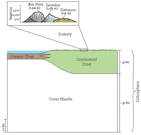
FIG 31.Scale diagram comparing average thicknesses of oceanic and continental crust and lithosphere.
In other cases the plate boundary is divergent , where the neighbouring plates move apart and new material from deeper within the Earth rises to fill the space created. The new oceanic crust is created by the arrival and cooling of hot volcanic material from below. The mid-Atlantic ridge running through Iceland, with earthquakes and volcanic activity, is one of the nearest examples to Britain of this sort of plate boundary.
Other plate boundaries mainly involve movement parallel to the plate edges and are sometimes called transform boundaries. The Californian coast zone is the classic example but there are many others, such as the transform boundary between the African and Antarctic plates. In some areas, plate movement is at an oblique angle to the suture and there are components of divergence or convergence as well as movement parallel to the boundary.
Britain today sits in the stable interior of the western Eurasian plate, almost equidistant from the divergent mid-Atlantic ridge boundary to the west and the complex convergent boundary to the south where Spain and northwest Africa are colliding. In its earlier history the crust of Britain has been subjected to very direct plate boundary activity: the results of convergent activity in Devonian and Carboniferous times (between 416 and 299 million years ago) are visible at the surface in southwest England, and in Ordovician to Devonian times (between 490 and 360 million years ago) in Wales, northwest England and Scotland.
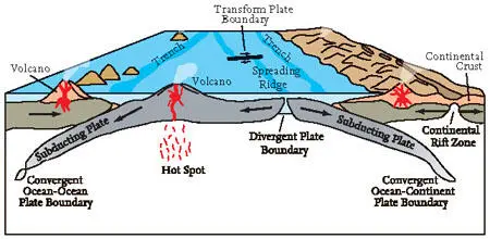
FIG 32.Diagram illustrating the movement processes of plates (not to scale).
UNDERSTANDING SURFACE MOVEMENTS
We have been considering the large movement systems that originate within the Earth. There are also more local movement systems operating on the Earth’s surface, which are linked to a very variable degree to the large-scale movements of plate tectonics. To explore this complex linkage further, it will be helpful to look now at different processes that may combine to cause particular local movements.
Horizontal movements as part of convergence, divergence or lateral transfer
Tectonic plates are recognised by their rigidity, so there is relatively little horizontal movement between points within the same plate compared to the deformation seen in plate boundary zones. This extreme deformation may involve folding and fracturing of the rock materials, addition of new material from below, or absorption of material into the interior during subduction.
Nonetheless, deformation is not restricted solely to plate boundaries, and does occur to a lesser extent within the plates. In some cases, major structures that originally formed along a plate boundary can become incorporated into the interior of a plate when prolonged collision causes two plates to join. Southern England includes the remains of a former convergent plate boundary and contains many examples of structures of this sort (particularly around Dorset and the Isle of Wight). These structures have often been reactivated long after they first formed in order to accommodate forces along the new plate boundary via deformation within the plate. Conversely, changes of internal stress patterns can sometimes lead to the splitting of a plate into two, forming a new, initially divergent plate boundary. Many of the oil- and gas-containing features of the North Sea floor originated when a belt of divergent rift faults formed across a previously intact plate.
It needs to be stressed that the patterns of deformation (fracturing and folding) due to these plate motions occur at a wide range of different scales, from centimetres to thousands of kilometres. Sometimes they are visible at the scale of an entire plate boundary, such as the enormous Himalayan mountain chain that marks the collision of India with Asia.
The effects of features as large as plate boundaries on landscapes persist over hundreds of millions of years, long after the most active movement has ceased. For example, parts of southwestern England, Wales and the Scottish Highlands are underlain by bedrocks that were formed in convergent boundary zones of the past. The tin and lead mines of Cornwall owe their existence to a 300-million-year-old convergent plate boundary, where an ocean was destroyed as two plates converged and continents collided. The convergence released molten rock that rose in the crust and gradually cooled to form granite, while metals were precipitated in the surrounding crust as ‘lodes’ containing tin and lead (see Chapter 4).
Mapping the patterns of bedrock exposed at the surface often reveals folds and faults that provide key information about the movements that have taken place during the past. Figure 33 provides a key to some of the terms commonly used to classify these structures as a step towards understanding the sorts of movement patterns that they represent. In broad terms, folds tend to indicate some form of local convergent movement, though they may be the result of larger movement patterns of a different kind. Normal faults tend to indicate divergent movements, at least locally, whereas reverse and strike-slip faults tend to indicate convergence. Two broad types of fold are distinguished: synclines are u-shaped downfolds, while anticlines are the opposite – n-shaped upfolds.
Further mapping of folds and faults often reveals complex patterns of changing movements. In the example shown in Figure 34, divergent movements in an area of crust produce plastic deformation in the warmer lower crust, and faulting into a number of discrete blocks in the colder, more brittle, upper crust. This is then followed by an episode of convergent movement that results in closing up the upper crustal blocks and further flow in the plastic lower crust, causing crustal thickening and mountain building at the surface.
Vertical crustal movements as part of other crustal movements
The movement of lithospheric plates is the main cause of convergent and divergent movements affecting thousands of kilometres of the Earth’s surface. As shown in Figures 33 and 34, these horizontal movements are generally accompanied by vertical movements that can produce very large scenic features, such as a mountain belt or a rift valley. In this book we are primarily concerned with scenic features at a more local scale, so we now consider various other processes that may be important in creating vertical crustal movements without contributions from large-scale plate interactions.
Читать дальшеИнтервал:
Закладка:
Похожие книги на «Southern England»
Представляем Вашему вниманию похожие книги на «Southern England» списком для выбора. Мы отобрали схожую по названию и смыслу литературу в надежде предоставить читателям больше вариантов отыскать новые, интересные, ещё непрочитанные произведения.


Обсуждение, отзывы о книге «Southern England» и просто собственные мнения читателей. Оставьте ваши комментарии, напишите, что Вы думаете о произведении, его смысле или главных героях. Укажите что конкретно понравилось, а что нет, и почему Вы так считаете.