Peter Friend - Scotland
Здесь есть возможность читать онлайн «Peter Friend - Scotland» — ознакомительный отрывок электронной книги совершенно бесплатно, а после прочтения отрывка купить полную версию. В некоторых случаях можно слушать аудио, скачать через торрент в формате fb2 и присутствует краткое содержание. Жанр: unrecognised, на английском языке. Описание произведения, (предисловие) а так же отзывы посетителей доступны на портале библиотеки ЛибКат.
- Название:Scotland
- Автор:
- Жанр:
- Год:неизвестен
- ISBN:нет данных
- Рейтинг книги:3 / 5. Голосов: 1
-
Избранное:Добавить в избранное
- Отзывы:
-
Ваша оценка:
Scotland: краткое содержание, описание и аннотация
Предлагаем к чтению аннотацию, описание, краткое содержание или предисловие (зависит от того, что написал сам автор книги «Scotland»). Если вы не нашли необходимую информацию о книге — напишите в комментариях, мы постараемся отыскать её.
Scotland — читать онлайн ознакомительный отрывок
Ниже представлен текст книги, разбитый по страницам. Система сохранения места последней прочитанной страницы, позволяет с удобством читать онлайн бесплатно книгу «Scotland», без необходимости каждый раз заново искать на чём Вы остановились. Поставьте закладку, и сможете в любой момент перейти на страницу, на которой закончили чтение.
Интервал:
Закладка:
South of the Southern Uplands Fault, the coast is generally rocky, with low cliffs and only small local beaches or small stretches of shingle. Cliffs are particularly well developed along the exposed western coast of the Rhins, reaching a maximum of 120 m in height near Dunman. This cliff line is largely inactive now, having been raised clear of wave action by crustal uplift. On the north coast of the Solway Firth in particular, the rocky coastline is punctuated by a number of large bays, generally river estuaries. The more sheltered conditions within these bays and the ample sediment supply have allowed wide expanses of sand-flat, mud-flat and salt-marsh to accumulate, and together the flats and marshes of the Solway Firth provide one of the largest continuous areas of intertidal habitat in Britain. Remnants of formerly more extensive lowland peat bogs are developed on raised estuarine sediments. These include the nationally important Lochar Moss and Moss of Cree.
Beaches are generally more common and extensive in this Area than in the Highlands of Scotland. The main reason for this is the relative abundance of sediment, primarily glacial sediment laid down on the near-shore shelf during the Devensian glaciation, and then driven onshore during the Flandrian sea-level rise, where it became stranded as sea levels fell again across the region. The relatively mild winds and waves experienced by the lowlands then meant that this abundant sediment source has remained fairly stable, and many of the beaches in this Area are still accreting today, rather than eroding. Old dune deposits are relatively common on the coastal strip south of Troon on the north edge of the Area, and sands were formerly worked from pits in these dune sands northwest of Monkton. Now, most of the dune deposits on the coast around Ayr are covered by golf courses.
Large expanses of tidal sand-flats are found along the southern coast of Area 1, and at low tide many kilometres of sand are exposed, such as at Mersehead Sands (20 km south of Dumfries). Further inland, the reworking of raised beach deposits and other sandy sediments by the wind has, in some coastal locations, produced extensive spreads of sand dunes, now for the most part anchored by coarse grass or forestry. The largest beach-dune system in southwest Scotland is found at the head of Luce Bay, home to a complex array of dune-related landforms, and still actively accreting today. The entire peninsula of the Rhins acts as a huge breakwater from the currents of the North Channel, creating the relatively calm waters of Loch Ryan and Luce Bay.
Salt-marshes are typically developed on low, raised beaches of sand or shingle and display a complex topography of pans, creeks and terraces. The salt-marshes of the Cree estuary in Wigtown Bay are particularly well developed, sandwiched between extensive sand-flats seawards and reed-swamps and emerged estuarine deposits (carse) landwards. The extensive carse deposits of the Cree estuary show that sedimentation has prevailed here over most of the last 10,000 years, despite changing sea levels. The estuary is well sheltered by Burrow Head to the south, and this has produced a largely unidirectional wave climate in which sediment is brought into the bay, with little subsequent removal. It appears that this system still operates, since many of the sand-flat and salt-marsh systems are accreting today. The presence of Sellafield-derived radionuclides attached to the sediment in the Cree and Water of Fleet sandbanks confirms the Outer Solway as a major sediment source, whilst important amounts of mud within the Cree mouth itself suggest a more fluvial source, further enhanced by active reworking of sediment from the carse deposits.
CHAPTER 7
Area 2: Southern Borders
AREA 2 COVERS THE CENTRAL PART of the Southern Uplands, sandwiched between Areas 1 (Galloway) and 5 (Edinburgh) ( Fig. 57). It straddles the southern part of the English–Scottish border, extending from Annandale and Moffatdale in the west to the Cheviot Hills in the east ( Fig. 58). The discussion provided here is restricted to features on the Scottish side of the border.
In the northern half of the Area, the River Teviot drains the relatively low-lying ground of Teviotdale, which in turn feeds into the larger Tweed Basin of Area 5 ( Chapter 2, Fig. 7). Teviotdale is bounded to the east by the Cheviot Hills and to the west by the Moffat Hills of the Southern Uplands. These rounded hills reach heights of over 800 m, and form a broad region of elevated ground which dominates the landscape in the northwestern part of this Area. The Solway Firth with its adjacent low-lying plains is the main feature of the southwestern corner of Area 2, along with the broad valleys of the Annan and Esk, which penetrate northwards into the hills of the Southern Uplands.
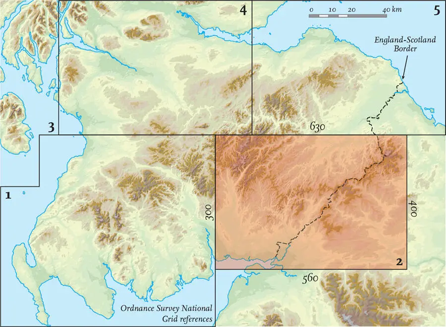
FIG 57. Location map for Area 2.
FIG 58. Natural and man-made features of Area 2.
STORIES FROM THE BEDROCK
Area 2 is principally made up of hard Ordovician and Silurian sediments, which are also the oldest rocks in the Area ( Figs 59, 60). These sandstones (greywackes), siltstones and shales were deposited between around 490 and 420 million years ago on the floor of the extensive Iapetus Ocean that, during this time, formed an Atlantic-scale ocean with Scotland and England on opposite margins. Around 490 million years ago, this ocean began to become smaller, as oceanic crust became subducted beneath the Grampian Highlands, and the Ordovician and Silurian sediments were scraped off the ocean floor and stacked up in a pile against the Midland Valley ( Fig. 28). This deformation created a fold system across the uplands of this Area, with the fold axes trending northeast to southwest. Superimposed on this larger structure are countless minor parallel folds, which give a ‘grain’ to the oldest bedrock of the Area. During these movements, the sediments were altered to brittle sandstones and slates.
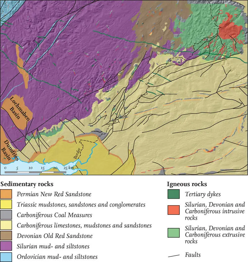
FIG 59. Simplified geology and hill-shaded topography for Area 2.
By the Devonian (around 410 million years ago), the major uplift and deformation of the Southern Uplands had ceased and the crustal materials of what are now Scotland and England became ‘welded’ along the Iapetus Suture. The mountainous ground of the Southern Uplands then began to be eroded, and large rivers flowed across the Area, depositing sandstones, siltstones and occasional conglomerates on lower-lying plains fringing the mountains. This Area lay in the interior of a large continent, and sediments accumulated on river flood plains where oxidising conditions led to the deposits being stained with red iron oxide. These Devonian sediments were deposited on the eroded surface of older, deformed Silurian and Ordovician rocks. This surface was far from uniform – in places, it had a relief of elevation of over 100 m. As a result, the thickness of the Devonian sediments varies from place to place, in part reflecting the fact that these river sediments were filling hollows in the topography. These deposits, collectively termed the Old Red Sandstone, today underlie a sizeable area just west of the Cheviot Hills.
FIG 60.Timeline of bedrock and surface-layer events in Area 2.
The early Devonian was also a time of igneous activity, and Devonian igneous rocks are often associated with interesting landscape features in Area 2. The largest area underlain by Devonian igneous bedrock is the Cheviot Hills in the northeast. Here, great thicknesses of sub-horizontal lava flows (predominantly mafic andesite) rest unconformably on Silurian marine sediments. This lava was extruded from an igneous centre that today straddles the border between Scotland and England. The centre experienced several stages of igneous activity: an initially explosive volcano was followed by a large out-pouring of lava, which today, after erosion, covers around 600 km2 of the Earth’s surface. This large area of lava was then intruded at depth by felsic granite, which after millions of years of erosion has been exhumed and today underlies the highest part of the Cheviot Hills, over the border in England. Elsewhere in the Area, much smaller Devonian volcanic vents and intrusions are relatively common.
Читать дальшеИнтервал:
Закладка:
Похожие книги на «Scotland»
Представляем Вашему вниманию похожие книги на «Scotland» списком для выбора. Мы отобрали схожую по названию и смыслу литературу в надежде предоставить читателям больше вариантов отыскать новые, интересные, ещё непрочитанные произведения.


Обсуждение, отзывы о книге «Scotland» и просто собственные мнения читателей. Оставьте ваши комментарии, напишите, что Вы думаете о произведении, его смысле или главных героях. Укажите что конкретно понравилось, а что нет, и почему Вы так считаете.