Peter Friend - Scotland
Здесь есть возможность читать онлайн «Peter Friend - Scotland» — ознакомительный отрывок электронной книги совершенно бесплатно, а после прочтения отрывка купить полную версию. В некоторых случаях можно слушать аудио, скачать через торрент в формате fb2 и присутствует краткое содержание. Жанр: unrecognised, на английском языке. Описание произведения, (предисловие) а так же отзывы посетителей доступны на портале библиотеки ЛибКат.
- Название:Scotland
- Автор:
- Жанр:
- Год:неизвестен
- ISBN:нет данных
- Рейтинг книги:3 / 5. Голосов: 1
-
Избранное:Добавить в избранное
- Отзывы:
-
Ваша оценка:
Scotland: краткое содержание, описание и аннотация
Предлагаем к чтению аннотацию, описание, краткое содержание или предисловие (зависит от того, что написал сам автор книги «Scotland»). Если вы не нашли необходимую информацию о книге — напишите в комментариях, мы постараемся отыскать её.
Scotland — читать онлайн ознакомительный отрывок
Ниже представлен текст книги, разбитый по страницам. Система сохранения места последней прочитанной страницы, позволяет с удобством читать онлайн бесплатно книгу «Scotland», без необходимости каждый раз заново искать на чём Вы остановились. Поставьте закладку, и сможете в любой момент перейти на страницу, на которой закончили чтение.
Интервал:
Закладка:
Pollen and beetle records indicate that temperatures in Area 1 may have risen to as warm as present by around 13,000 years ago, by which time southwest Scotland must have been completely deglaciated. Temperatures then fell sharply around 12,000 years ago, culminating in the Loch Lomond Stadial. This climatic deterioration was accompanied by the return of glaciers to parts of the Southern Uplands, although these glaciers were of very limited extent, generally being confined to the highest corries. Where glaciers developed, they bulldozed earlier till deposits into moraine ridges. A fine example of one such moraine is seen at Loch Dungeon, just southeast of Corserine. Steep cliffs of Silurian sediments rise from the southeast shore of the loch, and a subsidiary corrie of Corserine opens out on the northwest shore. A glacier emerged from this corrie, and its terminus is marked by a large terminal moraine to the west of the loch and by a shallow area within the loch itself.
Even in unglaciated upland areas, ice growth often caused extensive frost shattering. The scree and loose rock this produced is still visible today, particularly on summits and upper slopes, and has often been modified by subsequent flow to form a series of lobes and sheets. Elsewhere in the lowlands, the cold climate of the Loch Lomond Stadial made itself felt through the development of permafrost, as evidenced today by features such as ice wedge casts, seen most commonly in gravel pits. Evidence for periglacial disturbance and movement of the soil (solifluction) is also widespread on lowland slopes, usually affecting 1–2 m depth of soil, though in the valley floors of the Southern Uplands, great thicknesses of solifluction deposits have accumulated.
Post-glacial landscape development
At the end of the Loch Lomond Stadial, a temperature rise of around 7 °C occurred within just 700 years, marking the start of the current Flandrian (or Holocene) period. Although the effects of glaciation still dominate much of the landscape, in the 10,000 years since the disappearance of the last glaciers the land surface has been slowly adjusting to non-glacial conditions. These changes are particularly evident in areas of high relief, where glacial retreat exposed a bare rock landscape with over-steepened slopes. Soon after deglaciation, this landscape began adjusting to the new conditions, with rock falls, debris flows and reworking of glacial sediments. As the landscape re-equilibrated and soils and stabilising vegetation became established, it seems that these processes almost stopped, as shown by the vegetated, relict nature of most of the talus slopes, debris cones and alluvial fans in this Area.
Today, Area 1 is notable for its variety of river types and sizes, reflecting contrasts in relief and catchment size throughout the Area. Most of the main rivers originate in the high ground of the Southern Uplands and drain southwards, including the Nith, Cree and Dee ( Fig. 51). The upland tributaries of these rivers are akin to mountain torrents, becoming wandering gravel-bed rivers in their middle reaches as the relief becomes more subdued. Most of the major rivers have highly sinuous, meandering courses in their lower reaches, and drain into silty estuaries in the Solway Firth ( Fig. 55). The River Ayr, in the Midland Valley, has one of the most meandering courses in this Area, as it weaves across a flat lowland strewn with glacial deposits. Many of the lower reaches of the watercourses in this Area have been embanked to prevent flooding of adjacent land, and some of the smaller rivers show signs of having been straightened in the past.
The first vegetation to become established early in the Holocene was a juniper-dominated community, followed by birch and hazel around 9000 years ago, and then by oak and elm during the middle Holocene. Pine forest was present in the Galloway Hills, but was never the dominant species in this Area. From around 5000 years ago, human activity first began to have a significant impact on the landscape, primarily through forest clearance to make way for agriculture. There is evidence that woodland began to be progressively replaced by peat around 5000 years ago, and that by around 4200 years ago forest cover had essentially disappeared from the Area, replaced by blanket mire. This deforestation is thought to have led to enhanced soil erosion, with an increase in slope failure, debris flow activity and river incision. Peat has been the most widespread soil type in Area 1 since around 4000 years ago, in the form of blanket bog (including the internationally important Silver Flowe Bog in the low ground of the Loch Doon intrusion), or drier heather-covered slopes.
More recently, damming is another way in which humans have significantly altered parts of Area 1, flooding valleys to create reservoirs. The Galloway hydroelectric scheme was built between 1930 and 1936, and was the first of its kind in Scotland. Although small compared to some of the later Highland schemes, it is a model of unobtrusive and ecologically sensitive hydroelectric engineering, and is studied by engineers from around the world. Making use of water principally stored in Loch Doon, Clatteringshaws Loch and Loch Ken, the scheme includes eight dams, 12 km of tunnels, aqueducts and pipelines together with six power stations along 130 km of river. Whilst Loch Doon is on the site of a natural loch, damming has increased the water level by some 9 m, submerging various small islands. Before the Loch Doon dam was built, Loch Doon Castle, a thirteenth-century castle originally located on an island in the centre of the loch, was moved, stone by stone, to the adjacent bank where it now stands. Elsewhere, dam building flooded valleys, thereby significantly altering the landscape. Such reservoirs include Clatteringshaws Loch and Loch Ken on the Water of Ken. Loch Ken is now a major nature reserve and a breeding ground for many varieties of wild birds.
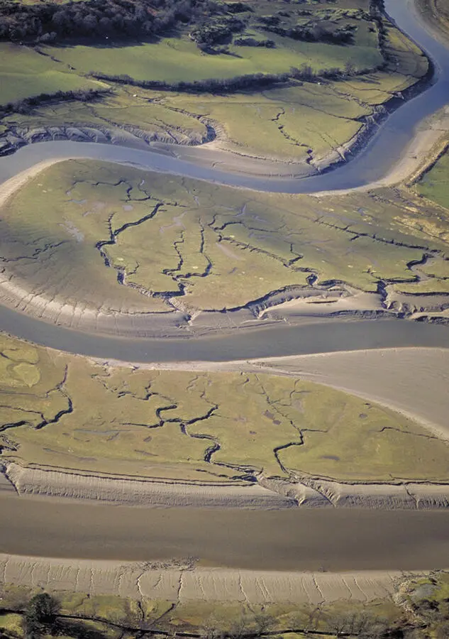
FIG 55. Tidal marshes showing typical, highly sinuous channels, where the wavelength of the channels cut in the muddy sediments reflects the tidal discharges involved. (© Patricia & Angus Macdonald/Aerographica/Scottish Natural Heritage)
Man has also altered the landscape by mining and quarrying activities, particularly prevalent in the Midland Valley where large opencast coal workings are still operational today in places, such as east of Patna. Recent clean-up efforts have greatly reduced the impact of colliery tips (bings) on the landscape, such as northeast of Girvan, where they have been landscaped and forested. Local stone has also been quarried for building stone, roadstone and crushed rock aggregate. An important source of building stone is the area around Mauchline, from which the attractive orange-red Permian sandstone has been extracted. Stone from this area has been widely used throughout the UK and Ireland, and even shipped to the USA. The granites have also been economically important for the region – the Glasgow and Liverpool docks, for example, were constructed using Criffel–Dalbeattie granite. Glacial sands, silts and gravels have also frequently been quarried, often leaving their mark on the landscape with flooded gravel pits.
Today, the Area is generally very wet and mild, as the North Atlantic Drift maintains higher temperatures than those found on the east coast. Indeed, plants normally associated with more southerly latitudes are found on the Rhins, along with dolphins and basking sharks off the coast. Much of the Southern Uplands in this Area lie within the Galloway Forest Park, managed by the Forestry Commission, and as well as rolling moorland, conifer plantations are common on the shallow, poor soils. The main river valleys (such as the Urr, Dee, Cree and Nith) provide a contrast to this rolling moorland, providing much of the good arable land of the Southern Uplands.
Читать дальшеИнтервал:
Закладка:
Похожие книги на «Scotland»
Представляем Вашему вниманию похожие книги на «Scotland» списком для выбора. Мы отобрали схожую по названию и смыслу литературу в надежде предоставить читателям больше вариантов отыскать новые, интересные, ещё непрочитанные произведения.


Обсуждение, отзывы о книге «Scotland» и просто собственные мнения читателей. Оставьте ваши комментарии, напишите, что Вы думаете о произведении, его смысле или главных героях. Укажите что конкретно понравилось, а что нет, и почему Вы так считаете.