Peter Friend - Scotland
Здесь есть возможность читать онлайн «Peter Friend - Scotland» — ознакомительный отрывок электронной книги совершенно бесплатно, а после прочтения отрывка купить полную версию. В некоторых случаях можно слушать аудио, скачать через торрент в формате fb2 и присутствует краткое содержание. Жанр: unrecognised, на английском языке. Описание произведения, (предисловие) а так же отзывы посетителей доступны на портале библиотеки ЛибКат.
- Название:Scotland
- Автор:
- Жанр:
- Год:неизвестен
- ISBN:нет данных
- Рейтинг книги:3 / 5. Голосов: 1
-
Избранное:Добавить в избранное
- Отзывы:
-
Ваша оценка:
Scotland: краткое содержание, описание и аннотация
Предлагаем к чтению аннотацию, описание, краткое содержание или предисловие (зависит от того, что написал сам автор книги «Scotland»). Если вы не нашли необходимую информацию о книге — напишите в комментариях, мы постараемся отыскать её.
Scotland — читать онлайн ознакомительный отрывок
Ниже представлен текст книги, разбитый по страницам. Система сохранения места последней прочитанной страницы, позволяет с удобством читать онлайн бесплатно книгу «Scotland», без необходимости каждый раз заново искать на чём Вы остановились. Поставьте закладку, и сможете в любой момент перейти на страницу, на которой закончили чтение.
Интервал:
Закладка:
The formation of the coastline
As described in Chapter 5, sea level in much of Scotland has not been constant, but has risen and fallen according to the interplay between global sea level and the elevation of the land. Global sea level decreases during an ice age, as water is locked up within the ice, and rises again as this ice melts. Meanwhile, during glacials, the crust becomes depressed locally under ice sheets, sinking into the mantle, and slowly rebounds once this ice has melted. The sea level at the coast at any one time therefore depends on the interplay between these two effects, and in the past sea level in Area 1 has been both higher and lower than at present. When sea level has remained constant for long enough, shorelines formed – marked today by erosional features such as rock-cut platforms backed by cliffs, or by beach deposits. Where subsequent uplift has outstripped global sea-level rise, these shorelines now take the form of raised beaches, raised deltas, raised estuarine deposits (known in Scotland as carse), and raised rock platforms and cliffs. Good examples of these features are found in this Area. Shore platforms are relatively common on stretches of rocky coastline, and are particularly well developed, for example, between the Heads of Ayr and Turnberry and around Ballantrae. In the latter area, numerous small caves and gullies often delineate the foot of the cliff, and occasional raised sea stacks rest on the raised platform. Further south, a shore platform can be traced around most of the Mull of Galloway at approximately 10 m above present sea level, and deposits of glacial till on top of it show that it predates the Devensian glaciation. In places, several shorelines are present, such as some 8 km southwest of Girvan, where two old shorelines give the skyline a stepped profile. These shorelines occur as a series of benches, commonly cut into boulder clay. Mafic, dolerite dykes have been etched out by the sea during the formation of each of these shorelines, and today stand as raised sea stacks.
In the lower-lying coastal areas, past increases in sea level involved the flooding of sometimes large patches of land. For example, along the Ayrshire coast the late glacial sea was nearly 30 m higher than at present, and so the sea would have come several kilometres inland from its present position. Along the Solway coast in the south of the Area, large sections of the present shore are backed by raised estuarine deposits of silt and clay, which provide valuable records of this sea-level change over the last 15,000 years. Good examples occur flanking the heads of the Cree and Fleet estuaries, which in this area lie between 7 and 10 m above present sea level.
The sediments within cores taken from the carselands flanking the Cree estuary have been analysed and dated, and have proved very useful in reconstructing the sea-level history of the Solway Firth, as summarised in Figure 56. These deposits show that sea level rose to cover this area by around 9600 years ago, followed by a rise to the so-called Main Post-glacial Shoreline by 6500 years ago, when sea levels were between 7 and 10 m above present and some 9 m of estuarine deposits were laid down in the Cree area. Sea level then fell from the uppermost carse surface to its present level as the land continued to rebound, whilst worldwide sea volume changed very little.
The large-scale shape of the coastline is controlled by a number of factors, many of which are in turn related to one another. Rising sea levels cause valleys to become flooded, forming bays and islands, whilst the location of these valleys often reflects rock type (i.e. hardness) and structure (both the presence of jointing within a rock unit and lines of weakness, such as faults). Climate and tidal energy also play an important role, controlling wave energy environments and terrestrial processes, such as sediment supply. The amount of sediment supply to a coast of course depends on the availability of that sediment, and in this regard glaciation has been very important. At the end of the Devensian, great volumes of glacial debris were deposited on the continental shelf. As sea level recovered to present levels, this sediment was reworked and moved towards the shore, to form the basis of our present beach and sand-dune systems. Today, where sediment supply is abundant, the coastline is currently advancing seawards, whilst in areas where sediment supply is in decline, the coastline is usually retreating through erosion. Humans, also, can have an impact – for example through building, quarrying, constructing sea defences and trampling of stabilising vegetation.
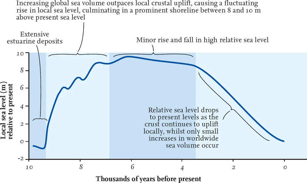
FIG 56. Sea-level curve for the Solway Firth. (Data from Smith et al. 2003, Transactions of the Royal Society of Edinburgh: Earth Sciences, 93, 301–31)
The number of large bays is one of the more obvious features of the coastal strip of Area 1. The main ones are Loch Ryan and Luce Bay, which together define the Rhins of Galloway, and Wigtown Bay further east. Numerous smaller bays are present along the south coast, including the Water of Fleet and Kirkcudbright Bay on the southeast side of Wigtown Bay. In general, these bays are located in the lower-lying ground of this Area, and therefore do not reflect a large difference in rock strength between headland and bay. Instead, they seem to roughly coincide with the large northwest/southeast faults shown in Figure 47, and with the outlets of major rivers. The exception is the Loch Ryan–Luce Bay pair, which may have been the site of a Tertiary river, now partially flooded by the sea.
Igneous rocks underlie some of the more prominent headlands on the west coast of Area 1, such as the Carboniferous vent rocks that make up the Heads of Ayr, a prominent headland some 6 km southwest of Ayr. The vent has been intruded into a colourful mix of Early Carboniferous sediments, including limestone, grey-green shales and red and green sandstones. Ash erupted from the Heads of Ayr vent is thought to underlie the knoll on which Greenan Castle has been built, around a kilometre up the shore towards Ayr. Where Silurian and Ordovician sedimentary rocks have been cut by cliff sections, the result is often rather impressive because of the exposed folding within the bedrock. Particularly spectacular ‘textbook’ examples of rock folds and other structures are found on the Machars peninsula, for example at Back Bay, just south of Monreith on the west coast, and around the Isle of Whithorn in the southeast. The fold structures at Back Bay not only illustrate two fold generations with a second set of folds superimposed on a first, but represent one of the most dramatic large-scale exposures of major re-folded folds in the UK.
Perhaps some of the most dramatic coastal scenery in Area 1 is found on the island of Ailsa Craig ( Fig. 50). Despite being only 1.2 km wide, the island is nearly surrounded by 340 m-high cliffs. The height of these cliffs reflects the exposed nature of the island to marine erosion, the strength and resistance of the bedrock to this erosion, and also the topographic high left behind here after the retreat of the last glaciers. For the most part, the foot of these cliffs is now between 5 and 10 m above sea level, and so marks a raised shoreline. A distinctive triangular raised beach is located on the eastern side of the island, fringed by storm ridges and an associated spit. These landform features highlight the importance of prevailing wind and storm direction, as they were caused by the westerly winds and waves since post-glacial times: sediment is deposited on the sheltered side of the island. The importance of exposure is also seen on the Rhins of Galloway, where the exposed western coast is generally rugged with steep cliffs and occasional inlets, in contrast to the calmer eastern coast with its sandy beaches.
Читать дальшеИнтервал:
Закладка:
Похожие книги на «Scotland»
Представляем Вашему вниманию похожие книги на «Scotland» списком для выбора. Мы отобрали схожую по названию и смыслу литературу в надежде предоставить читателям больше вариантов отыскать новые, интересные, ещё непрочитанные произведения.


Обсуждение, отзывы о книге «Scotland» и просто собственные мнения читателей. Оставьте ваши комментарии, напишите, что Вы думаете о произведении, его смысле или главных героях. Укажите что конкретно понравилось, а что нет, и почему Вы так считаете.