Peter Friend - Scotland
Здесь есть возможность читать онлайн «Peter Friend - Scotland» — ознакомительный отрывок электронной книги совершенно бесплатно, а после прочтения отрывка купить полную версию. В некоторых случаях можно слушать аудио, скачать через торрент в формате fb2 и присутствует краткое содержание. Жанр: unrecognised, на английском языке. Описание произведения, (предисловие) а так же отзывы посетителей доступны на портале библиотеки ЛибКат.
- Название:Scotland
- Автор:
- Жанр:
- Год:неизвестен
- ISBN:нет данных
- Рейтинг книги:3 / 5. Голосов: 1
-
Избранное:Добавить в избранное
- Отзывы:
-
Ваша оценка:
Scotland: краткое содержание, описание и аннотация
Предлагаем к чтению аннотацию, описание, краткое содержание или предисловие (зависит от того, что написал сам автор книги «Scotland»). Если вы не нашли необходимую информацию о книге — напишите в комментариях, мы постараемся отыскать её.
Scotland — читать онлайн ознакомительный отрывок
Ниже представлен текст книги, разбитый по страницам. Система сохранения места последней прочитанной страницы, позволяет с удобством читать онлайн бесплатно книгу «Scotland», без необходимости каждый раз заново искать на чём Вы остановились. Поставьте закладку, и сможете в любой момент перейти на страницу, на которой закончили чтение.
Интервал:
Закладка:
FIG 52. Hill-shade map of southwestern part of Area 1. The Southern Uplands Fault shows up well, as do other erosional and depositional features due to glaciation. Note the drumlins north and west of Patna Hill.
The fault which is most obvious in the landscape is the large Southern Uplands Fault. River and stream valleys have been preferentially eroded along the fault over much of its length. The fault is particularly prominent at its southwestern end ( Fig. 52), where it splits into two (the southern Glen App Fault and northern Stinchar Valley Fault: Fig. 47). Preferential weathering along the Glen App Fault has resulted in the remarkably steep-sided, linear valley of Glen App, whilst the more curved line of the Stinchar Valley Fault has been excavated and now underlies Stinchar Valley. In broader terms, the Southern Uplands Fault separates the generally higher, hillier ground of the Southern Uplands from the lower-lying, flatter ground of the Midland Valley. This change in topography is not, however, generally clear-cut across the fault, as Carboniferous and Permian sedimentary rocks infiltrate into the Southern Uplands along the Nith valley, as described above, whilst igneous rocks are relatively common just north of the Southern Uplands Fault within the Midland Valley and, as described later, have often resisted erosion to form hills comparable to those found just south of the fault.
Glacial landscape development
Whilst the broad outlines of the present Scottish landscape had probably been established by the end of the Tertiary, its detailed configuration owes much to events of the Quaternary period. During the last million years, ice sheets have repeatedly expanded to cover much of Scotland, including Area 1. These ice sheets flowed radially outwards from centres in the Highlands and Southern Uplands and were powerful agents of erosion and deposition, moulding the uplands, scraping sediments from the lowlands and locally depositing great thicknesses of boulder clay (till).
The most recent glacial episode, the Devensian, reached its coldest about 25,000 to 20,000 years ago, when an ice sheet centred on the Western Highlands and Southern Uplands had expanded to cover most of Scotland and all of Area 1. The broad pattern of ice flow during this time is shown in Figure 53: the thickest ice was centred on the Southern Uplands, and it flowed radially outwards from an ice divide that extended from Merrick in the west to the Lowther Hills in the east. Ice flowing northwards into the Midland Valley came up against southwards-flowing Highland ice, forcing ice to flow east and west across the low ground of central Scotland.
Landscape modification by glacial erosion
Glacial erosion has played an important role in creating the final shape of the landscape seen today. Most of Area 1 was extensively ice-scoured throughout the course of the Pleistocene glaciations, and the land surface present at the end of the Tertiary became heavily modified. Glacial erosion in this Area is most obvious in the uplands, which have been extensively ice-scoured. The mountains around the Loch Doon and Carsphairn igneous intrusions have an, albeit very rounded, Alpine form, with corries, rounded arêtes and intervening glacial troughs. These large-scale landforms were produced over the course of multiple glaciations, in particular by local valley and cirque glaciers during early and late phases of glaciation. The intensity of glacial erosion, at least during the Devensian glaciation, decreased eastwards towards the Lowther Hills, where more localised erosion took place: powerful ice streams continued to deepen the main valleys, but the intervening ridges and plateau were relatively unmodified. The corries that are relatively common in this southwestern part of the Southern Uplands are largely absent from the northeastern Southern Uplands. This could reflect a difference in climate from west to east, with the glaciers of the warmer, wetter southwest flowing much more vigorously, and hence eroding more than those of the colder, drier northeast, where the ice was frozen directly onto the rock and was therefore unable to scour deeply.
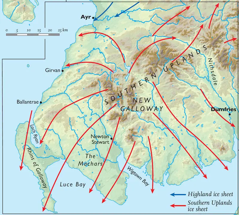
FIG 53. Generalised map of ice flow during the Devensian.
It is often the case in Scotland that, where granite intrusions are present in the bedrock, they are visible in the landscape because they form topographic highs. The relationship does not, however, seem to be so clear-cut in Galloway, where the different granite bodies have responded differently to both Tertiary and glacial erosion. The Cairnsmore of Fleet and Dalbeattie bodies do seem to be loosely associated with topographic highs: round, smoothed hills in the case of the Fleet body, and some of the only elevated ground on the south coast in the case of the Dalbeattie body ( Figs 47, 51). However, in both cases only part of the intrusion seems to have resisted erosion to form elevated ground: the western half of the Fleet body and the southeastern margin of the Dalbeattie. Elsewhere, the elevation of the land is not discernibly different to that underlain by the surrounding Palaeozoic metamorphics. However, a contrast is seen in the ‘texture’ of the land, with those areas underlain by granite or granodiorite having a much more ‘smoothed’ appearance, probably reflecting the more uniform nature of the rock, and its response to erosion, than the surrounding folded Silurian rocks. Likewise, the Carsphairn intrusion underlies the large hill of Cairnsmore of Carsphairn, with its knock-and-lochan topography and craggy faces. Again, however, there is no change in topography at the contact between the pluton and the surrounding rock, and the area north and east is almost equally as mountainous.
Something very different is associated with the Loch Doon granite. This area formed the centre of accumulation for the local icecap during the Devensian glaciation, and likely earlier, with glaciers moving outwards onto lower ground with an approximately radial pattern of flow. As such, it has been subject to intense glacial erosion, both under an extensive icecap during the glacial maximum and by local valley glaciers during early and late phases of glaciation. It is obvious from Figure 52that the Loch Doon pluton itself has resisted this erosion much less than the baked Ordovician sediments which surround it. These tough hornfels (baked sediments) today underlie the distinctive elevated ridge of peaks which almost completely surrounds the Loch Doon pluton. These hills include the Rhins of Kells, with Corserine (814 m) on the eastern flank and Merrick on the western flank ( Fig. 51), which at 843 m elevation is the highest point in Scotland south of the Highlands. The view from the summit of Merrick is exceptional, from Ben Cruachan northeast of Oban, across to the Paps of Jura and then south across the Isle of Man and the Lake District to Snowdonia. The granodiorite which makes up much of the Loch Doon pluton has a tendency to form the low boggy ground between these hills, averaging around 300 m elevation. Glacial rock basins have been gouged out of this granodiorite, and today they are flooded to form the numerous small lochs which are seen within the boundaries of the intrusion, such as Loch Enoch. Meanwhile, the granite which forms the centre of the intrusion is obviously more resistant than the granodiorite, and underlies a ridge of high ground including the hills of Craiglee, Hoodens and Mulwarchar (692 m).
Throughout these uplands, bare, scoured rock is relatively common, particularly around the Loch Doon and Carsphairn area, although the jagged peaks and cliffs common in the Highlands are mostly absent. Where present, this bare rock provides an interesting contrast to the otherwise rolling moorland. One particular craggy outcrop southwest of Loch Enoch has been named the ‘Grey Man of Merrick’, because of its resemblance to a man’s face when seen from the side. Another interesting feature is the so-called ‘Devil’s Bowling Green’ on Craignaw, a remarkably flat, smooth glaciated rock surface strewn with rounded boulders.
Читать дальшеИнтервал:
Закладка:
Похожие книги на «Scotland»
Представляем Вашему вниманию похожие книги на «Scotland» списком для выбора. Мы отобрали схожую по названию и смыслу литературу в надежде предоставить читателям больше вариантов отыскать новые, интересные, ещё непрочитанные произведения.


Обсуждение, отзывы о книге «Scotland» и просто собственные мнения читателей. Оставьте ваши комментарии, напишите, что Вы думаете о произведении, его смысле или главных героях. Укажите что конкретно понравилось, а что нет, и почему Вы так считаете.