Peter Friend - Scotland
Здесь есть возможность читать онлайн «Peter Friend - Scotland» — ознакомительный отрывок электронной книги совершенно бесплатно, а после прочтения отрывка купить полную версию. В некоторых случаях можно слушать аудио, скачать через торрент в формате fb2 и присутствует краткое содержание. Жанр: unrecognised, на английском языке. Описание произведения, (предисловие) а так же отзывы посетителей доступны на портале библиотеки ЛибКат.

- Название:Scotland
- Автор:
- Жанр:
- Год:неизвестен
- ISBN:нет данных
- Рейтинг книги:3 / 5. Голосов: 1
-
Избранное:Добавить в избранное
- Отзывы:
-
Ваша оценка:
Scotland: краткое содержание, описание и аннотация
Предлагаем к чтению аннотацию, описание, краткое содержание или предисловие (зависит от того, что написал сам автор книги «Scotland»). Если вы не нашли необходимую информацию о книге — напишите в комментариях, мы постараемся отыскать её.
Scotland — читать онлайн ознакомительный отрывок
Ниже представлен текст книги, разбитый по страницам. Система сохранения места последней прочитанной страницы, позволяет с удобством читать онлайн бесплатно книгу «Scotland», без необходимости каждый раз заново искать на чём Вы остановились. Поставьте закладку, и сможете в любой момент перейти на страницу, на которой закончили чтение.
Интервал:
Закладка:
Curves of local sea-level change for any area can be estimated (relative to the present) by recognising and dating various features that indicate elevations in ancient coastal profiles. These features, preserved in the rocks either above or below the present sea level, include former erosional cliff lines, wave-cut platforms and ancient tidal, estuarine or freshwater deposits. The similarity or otherwise of such curves to the eustatic curve ( Fig. 40) depends on whether the areas in question have been subjected to any localised solid Earth movements, such as ice loading or unloading.
Two examples of British sea-level curves, relative to the present, illustrate how the local uplift and subsidence history varies for different coastal areas around Britain. In the Thames Estuary, local evidence shows that a rise of some 40 m has taken place through time over the last 10,000 years, at first very rapidly but then more slowly between about 6,000 years ago and the present ( Fig. 41, red circles). Modelling of the processes involved, incorporating estimates of eustatic (global) sea-level change and local solid Earth movements, gives a fairly good match to the observational data ( Fig. 41, black line).
FIG 40. Generalised change of worldwide (eustatic) sea level over the past 18,000 years. (After Van Andel 1994, Fig. 4.11)
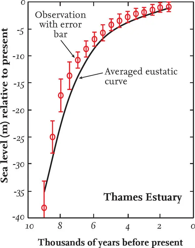
FIG 41.Relative sea-level curve for the Thames Estuary.
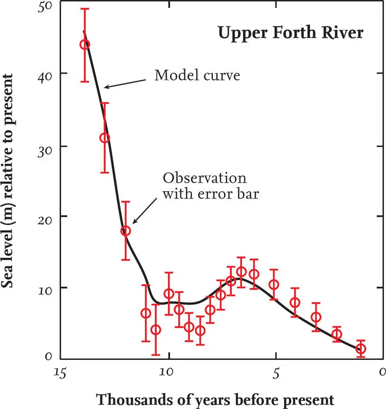
FIG 42. Relative sea-level curve for the upper River Forth at Arnprior.
Our second example of relative sea-level change comes from the upper River Forth and is quite different. It shows that there has been a fall of relative sea level of about 50 m over the past 15,000 years, so that former coastline features are now visible well above the present-day coast ( Fig. 42, red circles). This type of curve is common in Scotland and, given the ~120 m worldwide rise in sea level shown in Figure 40, it is clear that the crust of the Forth region must have been subjected to significant uplift (~170 m) in order to produce the curve shown in Figure 42. This uplift is largely the result of isostatic rebound due to unloading of the crust as the ice retreated.
In some curves, as with the upper Forth, oscillations in the curve represent changes in the rates at which the two mechanisms of change were operating. Such changes may leave characteristic coastline features in the landscape, which will be considered in the Area descriptions.
At larger scales, it is useful to consider average rates of crustal movement over a given time period, which can then be plotted as contour maps. The contours shown on Figure 43are based on estimates of local elevation changes averaged over roughly the last 5,000 years, attempting also to allow for the effects of eustatic sea-level variations. Additional support for this approach comes from data from tide-gauge studies, collected over the last 200 years, which show some consistency with this pattern.
Although our two local studies in the Thames region and the upper Forth ( Figs 41, 42) involve a rather longer timescale than the regional analysis ( Fig. 43), all three studies highlight the clear contrast between crustal movements in southeastern England and those in western and central Scotland. These variations have been produced by differences in ice-sheet thickness and extent during the last (Devensian) glacial.
The distinctive rise of the land of Scotland relative to sea level lends itself to another approach to the study of sea-level change. Figure 44shows a plot of the elevations and gradients of various old shoreline features that are now above present-day sea level across Scotland and northern England. These old shoreline features have clearly been uplifted, and those further inland have generally risen more than those near to the present-day coast, so that they now form a dome-like structure. This dome is broadly centred on Rannoch Moor, which was one of Scotland’s main ice centres during the last glaciation. We can therefore usefully identify a Rannoch Rebound Dome as an active feature of local Earth movement, resulting from unloading of the crust of western Scotland in response as the Devensian ice melted.
FIG 43. General trends of crustal movement, relative to sea level, averaged over the last 5000 years.
FIG 44. The elevations and gradients of various old shoreline features along a horseshoe-shaped traverse across northern Britain, suggesting the Rannoch Rebound Dome.
CHAPTER 6
Area 1: Galloway
AREA 1 EXTENDS FROM AYR in the northwest down to Dumfries in the southeast ( Fig. 45). It lies mainly within the western half of the Southern Uplands, a terrain of rolling hills, bounded to the west by the Firth of Clyde and its numerous sandy bays. The Southern Uplands Fault crosses the northern half of the Area, separating the Southern Uplands from the generally lower-lying ground of the Midland Valley, with its volcanic hills and important coal reserves ( Fig. 46).
People have inhabited this Area for thousands of years, and it was an important gateway between England and Ireland. There are many remains of human occupation dating from prehistoric times to the present day, ranging from Mesolithic fish traps to medieval burghs and castles. Another interesting feature of Area 1 is the unusual place names, particularly in the Southern Uplands themselves, where Old Norse, Gaelic and Celtic influences can be seen. Examples are the Rig of the Jarkness and the Dungeon of Buchan.
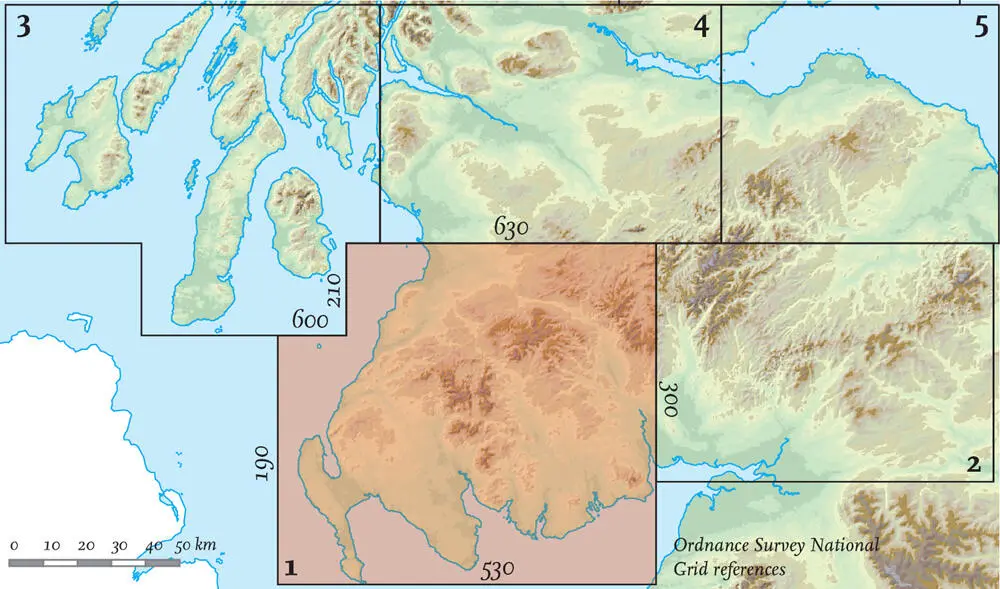
FIG 45. Location map for Area 1.
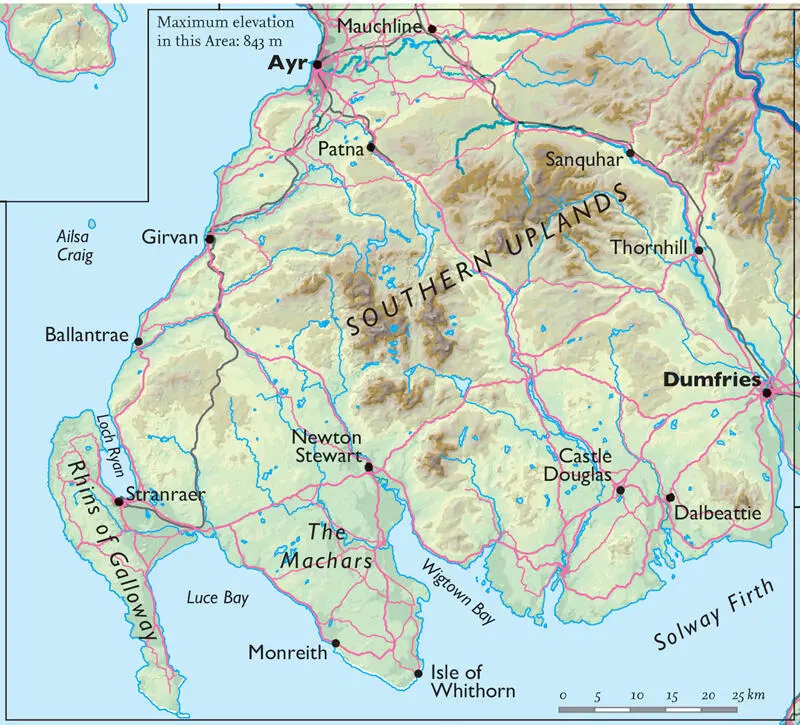
FIG 46. Natural and man-made features of Area 1.
STORIES FROM THE BEDROCK
Geologically speaking, Area 1 lies mainly within the Southern Uplands terrane, sandwiched between the Iapetus Suture in the south and the Southern Uplands Fault in the north (see Fig. 20, Chapter 4). The bedrock of the Southern Uplands ( Figs 47, 48) is mostly altered Ordovician and Silurian sedimentary rocks, deposited between 490 and 420 million years ago on the floor of the Iapetus Ocean (see Chapters 1– 5). The sediments which make up this bedrock were swept off a nearby continental shelf and down the continental slope in turbid (muddy, cloudy) currents – underwater avalanches, more dense than the surrounding sea water – that were probably earthquake-triggered. On reaching the flat ocean floor, the entrained sediments in each avalanche gradually settled – coarse sands first, followed by fine sand, and then the much slower deposition of clay and mud. In this way, each turbid current resulted in a graded bed, from coarse-grained at the bottom to fine-grained at the top, and as the process repeated itself many times, a thick sequence of such beds built up. Small amounts of limestone were also deposited, along with volcanic material such as pale ash layers. Graptolites – small, now-extinct marine animals – are common in the fine-grained sediments of the Southern Uplands. Their rapid evolutionary changes of form mean they have become very useful time markers for determining the relative ages of different sedimentary beds, especially when combined with studies of the folds and faults, in reconstructing the origins of the Southern Uplands.
Читать дальшеИнтервал:
Закладка:
Похожие книги на «Scotland»
Представляем Вашему вниманию похожие книги на «Scotland» списком для выбора. Мы отобрали схожую по названию и смыслу литературу в надежде предоставить читателям больше вариантов отыскать новые, интересные, ещё непрочитанные произведения.


Обсуждение, отзывы о книге «Scotland» и просто собственные мнения читателей. Оставьте ваши комментарии, напишите, что Вы думаете о произведении, его смысле или главных героях. Укажите что конкретно понравилось, а что нет, и почему Вы так считаете.