L. Stamp - Britain’s Structure and Scenery
Здесь есть возможность читать онлайн «L. Stamp - Britain’s Structure and Scenery» — ознакомительный отрывок электронной книги совершенно бесплатно, а после прочтения отрывка купить полную версию. В некоторых случаях можно слушать аудио, скачать через торрент в формате fb2 и присутствует краткое содержание. Жанр: unrecognised, на английском языке. Описание произведения, (предисловие) а так же отзывы посетителей доступны на портале библиотеки ЛибКат.
- Название:Britain’s Structure and Scenery
- Автор:
- Жанр:
- Год:неизвестен
- ISBN:нет данных
- Рейтинг книги:3 / 5. Голосов: 1
-
Избранное:Добавить в избранное
- Отзывы:
-
Ваша оценка:
Britain’s Structure and Scenery: краткое содержание, описание и аннотация
Предлагаем к чтению аннотацию, описание, краткое содержание или предисловие (зависит от того, что написал сам автор книги «Britain’s Structure and Scenery»). Если вы не нашли необходимую информацию о книге — напишите в комментариях, мы постараемся отыскать её.
Britain’s Structure and Scenery — читать онлайн ознакомительный отрывок
Ниже представлен текст книги, разбитый по страницам. Система сохранения места последней прочитанной страницы, позволяет с удобством читать онлайн бесплатно книгу «Britain’s Structure and Scenery», без необходимости каждый раз заново искать на чём Вы остановились. Поставьте закладку, и сможете в любой момент перейти на страницу, на которой закончили чтение.
Интервал:
Закладка:
The variety of habitat for marine bottom-living creatures in the shallow water of the continental shelf, is more than paralleled by the variety of habitat along the sea-shore itself.
Broadly speaking, any stretch of coastline is either one of erosion or of deposition and along such a varied coastline as that of the British Isles the conditions change with great frequency. A cliff coast is obviously an erosion coast and a high or irregular cliff line may be taken as indicative of long-continued erosion. Coast erosion was the subject of an exhaustive inquiry by a Royal Commission which reported in 1911 and much attention was given to the rate of cliff erosion.
FIG. 20.—Diagrams showing the Drift of Shingle along a Shelving Beach. In each diagram the dotted line shows the course of a single pebble. It is thrown up the beach parallel to the direction of the prevailing waves but is dragged down the beach roughly parallel to the slope of the beach by the force of gravity. As the process is repeated the pebble works its way, with all its fellows, along the shore. If groynes are erected, this longshore drifting is partly arrested (Plate IX).
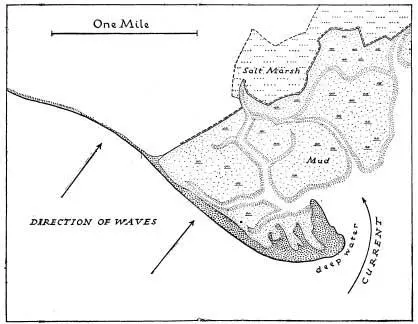
FIG. 21.—A Shingle Spit and Salt-Marshes Hurst Castle Spit, Hampshire
The chalk cliffs of the Strait of Dover appear to be receding at a rate which suggests the widening of the Strait by half a mile in a thousand years—an average of 15 inches on each side per year. In parts of the low soft Norfolk coast up to 5 feet per year is possible, whilst great cliff falls may give spectacular figures in cliffs which otherwise are being eroded at the rate of only an inch or two a year.
A change from erosion to deposition is seen with cliffs in front of which shingle banks are accumulating. Taking Britain as a whole, even without human interference more land is being gained at present than is being lost. The material from a yard or two of high cliff would spread over a large superficial area of mud-flat. Allowing for man’s action the gain is very much greater than the loss. Accumulation along a coast may take many forms—among the chief of which are shingle beaches and spits, sandy bays often backed by sand dunes, and mud-flats.
A study of shingle beaches and spits gives a clue to many of the essential features of coastal evolution. For long it was believed, and actively advocated by many writers, that longshore currents were mainly responsible for the drift of shingle and sand along coastlines. That there is a drift of material along shores is quite clear and is immediately apparent where groynes have been built to minimise the movement—the shingle is piled up on one side of the groyne and swept away from the other. This is clearly shown in Plate IX of the shore at Folkestone. In recent years, however, it has been shown, notably by W. V. Lewis, that the drift of material is occasioned by wave action and not by currents. There is a constant tendency for shingle beaches to be piled up so that the ridges are at right angles to the dominant wave direction—in other words the shingle ridges are built up parallel to the ridges and troughs of the waves that create them. Where, owing to the general trend of the coastline, the waves break obliquely, the pebbles are thrown up slightly obliquely but the undertow drags them back more nearly at right angles to the direction of the shore so that they travel gradually along the coast, as shown in Fig. 20. There is, in consequence, the familiar phenomenon of a spit being built out, often right away from the coast line, but at right angles to the direction of the waves. A well-known example is Hurst Castle spit on the Hampshire coast opposite the Isle of Wight. Elsewhere successive shingle beaches may be built up—especially in time of storm, as at Dungeness. Dungeness is remarkable for the extensive area of successive shingle beaches. The spits of shingle or sand which are associated with river mouths are rather different in character: a drift of material deflects the channel of the river. Behind shingle spits and sand spits conditions tend to be favourable for the accumulation of mud and the development of salt marshes.
With sandy shores, wind nearly always takes a hand. The dominant wave direction (as on the coasts of north Cornwall) is often that of the predominant westerly winds. Such areas as Saunton Sands and Perranporth illustrate the formation of sandy beaches at right angles to this direction. Further, these sandy beaches are backed by large areas of sand dunes. Above high-water mark the sand, quickly dried by the wind and sun, is blown inland to form dunes, in due course to be fixed in the usual way by Marram Grass (Ammophila) and other sand-dune plants. Wind action is especially important during short or neap tides when an expanse of sea sand below the high-water mark of spring tides is dried and blows easily.
FIG. 22.—An Atlantic Coastline with shingle beaches and sand-dunes at right angles to dominant wave direction (shown by the arrows). Rocky, hilly headlands separate the bays and indicate the east-west strike of the rocks.
Around the shores of Britain there are some remarkably large areas of silt and mud covered only at high tide. Around parts of the Wash high and low tide marks may be several miles apart and the same is true of parts of the Thames estuary, the Bristol Channel, Morecambe Bay and Solway Firth. In these areas there is a steady accretion to the land and the salt-marshes which are developed exhibit the well-known zonation of their vegetation. Reclamation of such areas goes on steadily round many parts of the coast: when the silting has gone on so that the mud-flats are covered only by the higher tides, they are enclosed by earth banks and at first water let in at high tides is allowed to deposit more mud and then to run off gently. Then the entrance of salt water is later prevented and gradually rain water washes the salt out of the soil so that fresh-water marsh replaces salt marsh. After some eight or ten years the ground is sufficiently free from salt for ploughing to be possible.
Such are the features associated respectively with erosion coasts and coasts of accretion. There are other features associated with eustatic movement of elevation or depression. A rising coast frequently shows raised beaches—wave-cut platforms on which rest gravels, sands and other beach- or shallow-water deposits and which are frequently bounded on the landward side by lines of old or “fossil” cliffs. Such raised beaches are well seen round many parts of Britain ; especially famous are the examples along the Clyde estuary. Along the rocky coast of Cornwall the raised beaches are but narrow platforms cut in the hard rocks. Of other striking examples from Scotland one has been chosen for illustration in Plate XI.
A sinking coast or drowned coastline is often highly indented for the sea naturally invades the mouths and lower sections of river valleys and runs up the valleys of tributary streams. Excellent examples are seen along the south coasts of Devon and Cornwall, as illustrated in Plate 26. Local features such as submerged forests are indicative of a sinking or a sunken coastline. A fascinating little book by the late Clement Reid on Submerged Forests described the very numerous examples round the British Isles. Summer visitors perhaps know best those along the coasts of East Anglia and Lincolnshire, West Cornwall or Cheshire.
A distinction is frequently drawn between the “Atlantic” and “Pacific” types of coastline, so-called because of their relative prevalence round those two oceans respectively. In the Atlantic type the “grain” of the country, the axes of the folds in the rocks, is at right angles to the dominant direction of the coast.
Читать дальшеИнтервал:
Закладка:
Похожие книги на «Britain’s Structure and Scenery»
Представляем Вашему вниманию похожие книги на «Britain’s Structure and Scenery» списком для выбора. Мы отобрали схожую по названию и смыслу литературу в надежде предоставить читателям больше вариантов отыскать новые, интересные, ещё непрочитанные произведения.


Обсуждение, отзывы о книге «Britain’s Structure and Scenery» и просто собственные мнения читателей. Оставьте ваши комментарии, напишите, что Вы думаете о произведении, его смысле или главных героях. Укажите что конкретно понравилось, а что нет, и почему Вы так считаете.