L. Stamp - Britain’s Structure and Scenery
Здесь есть возможность читать онлайн «L. Stamp - Britain’s Structure and Scenery» — ознакомительный отрывок электронной книги совершенно бесплатно, а после прочтения отрывка купить полную версию. В некоторых случаях можно слушать аудио, скачать через торрент в формате fb2 и присутствует краткое содержание. Жанр: unrecognised, на английском языке. Описание произведения, (предисловие) а так же отзывы посетителей доступны на портале библиотеки ЛибКат.
- Название:Britain’s Structure and Scenery
- Автор:
- Жанр:
- Год:неизвестен
- ISBN:нет данных
- Рейтинг книги:3 / 5. Голосов: 1
-
Избранное:Добавить в избранное
- Отзывы:
-
Ваша оценка:
Britain’s Structure and Scenery: краткое содержание, описание и аннотация
Предлагаем к чтению аннотацию, описание, краткое содержание или предисловие (зависит от того, что написал сам автор книги «Britain’s Structure and Scenery»). Если вы не нашли необходимую информацию о книге — напишите в комментариях, мы постараемся отыскать её.
Britain’s Structure and Scenery — читать онлайн ознакомительный отрывок
Ниже представлен текст книги, разбитый по страницам. Система сохранения места последней прочитанной страницы, позволяет с удобством читать онлайн бесплатно книгу «Britain’s Structure and Scenery», без необходимости каждый раз заново искать на чём Вы остановились. Поставьте закладку, и сможете в любой момент перейти на страницу, на которой закончили чтение.
Интервал:
Закладка:
In the British Isles we are concerned with the land-forms which develop in a moist, temperate climate. We are not, for example, directly concerned with land-forms which develop in hot deserts or in the rainy tropics except in so far as such conditions once prevailed in distant geological epochs and have bequeathed to us fragments of “fossil” landscapes in the sun-shattered rocks which peep from beneath a cover of later strata in the Wrekin or the ridges of Charnwood Forest to remind us of the deserts of Triassic days. We are, however, concerned with land forms which develop under conditions of extreme cold under great ice-sheets or valley glaciers or on the margins of ice-covered seas, for much of the surface of this country was profoundly modified during the Great Ice Age. This is geologically so recent that not a few of our lakes and swamps are the last remains of those left behind by the retreating ice.
Over large parts of this country the relief seems to be completely unrelated to the underlying structure. Plains are developed quite independently of either the hardness or dip of the underlying rocks: rivers seem to go out of their way (as does the Bristol Avon) to pass through the highest hill ranges they can find instead of following an easy passage on low ground and it is here that we realise the importance of the erosion cycle. It is in the interpretation of such apparent anomalies that the geomorphologist has made his major contribution. In the following pages we shall examine in detail a number of examples from Britain.
THE WORK OF RIVERS
The principal agent in the sculpturing of the land surface in a rainy temperate climate such as that of Britain is undoubtedly running water. No sooner does rain fall than some of it collects to form tiny temporary rivulets which soon join small permanent brooklets and rills. These, reinforced by springs which represent the reappearance at the surface of that portion of the rainwater which had soaked into the ground, unite in due course to form the river system of the country. Except in certain limestone districts where much of the drainage is underground the whole country is covered with a complex surface drainage pattern of rivers and streams.
It is a common generalisation in most books on physical geography that the course of a river may be divided into three parts. The upper or mountain course is that in which swiftly flowing water, especially after rain, is able to move stones of considerable size, to roll them along, to rub them one against the other and so to reduce angular fragments such as those broken off the mountains by frost action into rounded pebbles. The work of such a mountain torrent is well seen in Plate 2. At the same time the river deepens and widens its own valley so that its valley has a typical V-section with unstable banks. The middle course of the river is that over the foothill belt where it has lost some of its velocity but is still moving rapidly enough to carry sand, silt and mud in suspension and to roll pebbles along its bed. Its main work there is transportation ; its valley has a broad open section and has stable sides so that the erosive power of the river is strictly limited. The lower course is that in which the river meanders lazily across a plain ; though sweeping much mud out to sea or into the lake into which it empties it has lost much of its velocity and so much of its power of transportation. It lays down part of its load as shingle beaches or sandbanks but especially builds up large flat plains of deposition by spreading alluvium over a wide flood plain or a delta. Thus its work is largely deposition.
Quite obviously not all rivers conform to such a generalised pattern. In mountainous regions they may tumble direct from the mountains to the sea (as shown on Plate XXVIII)—they are young rivers associated with an early stage in the cycle of erosion. Others, including such large rivers of this country as the Thames, have no mountain course—they are relatively mature and associated with a late stage in the cycle of erosion.
It is clear that there is a very close relationship between the character of a river and the phase of the erosion cycle.
FIG. 12.—Diagram of a Meandering River This diagram shows how the water of even a slowly-moving river in its lower course swings from side to side resulting in erosion on the concave side and deposition of sandbanks on the convex side.
It is the inexorable law of nature that as soon as mountain building movements have erected a land mass and endowed it with mountains, hills and valleys, the forces of sub-aerial denudation combine to reduce that land to…the question is to what? What is the final form of the land if the forces of denudation are allowed to continue unchecked? The answer is not a flat plain but a peneplain or peneplane which, whichever way it is spelt, means almost a flat surface. The whole process is referred to as “sub-aerial peneplanation.” Although sub-aerial peneplanation is in progress all over the world and although large areas may thus have been so reduced that they have reached “base level”, below which removal of material will not take place, it is rarely if ever in nature that the process is allowed to continue to its logical conclusion. Differential uplift of the land, up or down movements relative to sea level (eustatic movements), or even a slight folding movement will upset the equilibrium which has been reached and will cause “rejuvenation” of the river systems. Before considering these complications it will be well to note the various ways in which river systems may develop and thereby to explain many of the features which are associated with British rivers. In passing we may recall that peneplanation of lands in the British Isles has probably been almost reached in past geological epochs.
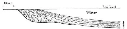
FIG. 13.—Diagrammatic Section through the Deposits of a Delta and a Lake or the Sea When the river enters a lake or the sea, the velocity of the water is immediately checked and any coarse material is at once dropped, only the finer mud being carried on. In this way a delta is built up and as the flat land of the delta itself is formed, the velocity of the river is checked before reaching the sea and the finer deposits are spread as a surafce layer of alluvium over the flood plain.
The formation of shallow water limestones which requires clear water is taken as evidence that the surrounding lands had been almost reduced to base level and consequently yielded very little sediment.
We notice that there are thus two types of plains—plains of deposition and plains of denudation and that the former tend to be flatter and are more truly plains.
Let us take the simple case of the floor of the sea which is raised up (not folded) by earth movements so that it becomes land. It will be a flattish surface with a gentle slope seawards and rain falling will collect together into streams, roughly parallel, finding the shortest route seawards. These streams are consequent on the slope and hence are known as consequent streams. Tributary streams, arranged somewhat irregularly, will drain into these main ones and the pattern of drainage developed is that known as dendritic.
FIG. 14
FIG. 15
FIG. 16
Читать дальшеИнтервал:
Закладка:
Похожие книги на «Britain’s Structure and Scenery»
Представляем Вашему вниманию похожие книги на «Britain’s Structure and Scenery» списком для выбора. Мы отобрали схожую по названию и смыслу литературу в надежде предоставить читателям больше вариантов отыскать новые, интересные, ещё непрочитанные произведения.


Обсуждение, отзывы о книге «Britain’s Structure and Scenery» и просто собственные мнения читателей. Оставьте ваши комментарии, напишите, что Вы думаете о произведении, его смысле или главных героях. Укажите что конкретно понравилось, а что нет, и почему Вы так считаете.