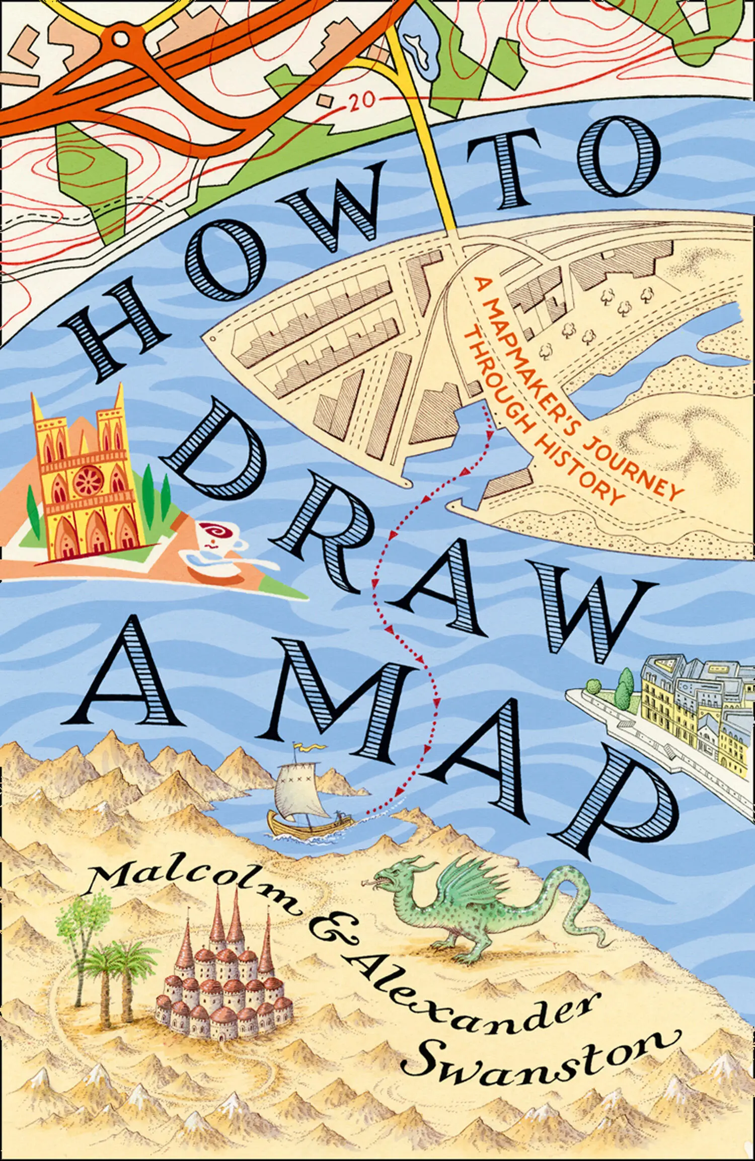
Malcolm Swanston - How to Draw a Map
Здесь есть возможность читать онлайн «Malcolm Swanston - How to Draw a Map» — ознакомительный отрывок электронной книги совершенно бесплатно, а после прочтения отрывка купить полную версию. В некоторых случаях можно слушать аудио, скачать через торрент в формате fb2 и присутствует краткое содержание. Жанр: unrecognised, на английском языке. Описание произведения, (предисловие) а так же отзывы посетителей доступны на портале библиотеки ЛибКат.
- Название:How to Draw a Map
- Автор:
- Жанр:
- Год:неизвестен
- ISBN:нет данных
- Рейтинг книги:4 / 5. Голосов: 1
-
Избранное:Добавить в избранное
- Отзывы:
-
Ваша оценка:
How to Draw a Map: краткое содержание, описание и аннотация
Предлагаем к чтению аннотацию, описание, краткое содержание или предисловие (зависит от того, что написал сам автор книги «How to Draw a Map»). Если вы не нашли необходимую информацию о книге — напишите в комментариях, мы постараемся отыскать её.
How to Draw a Map — читать онлайн ознакомительный отрывок
Ниже представлен текст книги, разбитый по страницам. Система сохранения места последней прочитанной страницы, позволяет с удобством читать онлайн бесплатно книгу «How to Draw a Map», без необходимости каждый раз заново искать на чём Вы остановились. Поставьте закладку, и сможете в любой момент перейти на страницу, на которой закончили чтение.
Интервал:
Закладка:
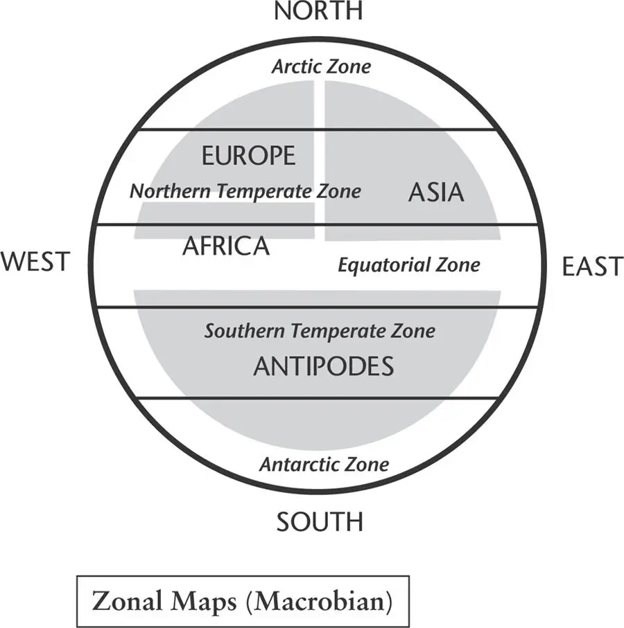
Map 11. These maps are sometimes called ‘Macrobian’, after the Roman administrator and author Ambrosius Aurelius Theodosius Macrobius.
In the maps known as Beatus, or Quadripartite, east is again shown at the top, where the Garden of Eden is located – a focal point of Christian belief. These maps show the three known continents plus a new and unknown continent to the south, hence the name Quadripartite. This fourth continent is often called Antipodes. The Beatus maps are named after Beatus of Liébana, a monk and theologian with a keen interest in geology. In the years running up to his birth in around 730 CE the bulk of Visigothic Spain had been overrun by Muslim invaders of the Umayyad dynasty, with the exception of the kingdoms of north-west Spain, the home of Beatus. The most accurate mapmakers of the day were Arabic, and their maps would have influenced the young monk, who is now best remembered for his work Commentary on the Apocalypse of St John , published in 776 with revisions in 784 and 786. The Beatus maps that now exist are believed to derive from an original now lost to us.
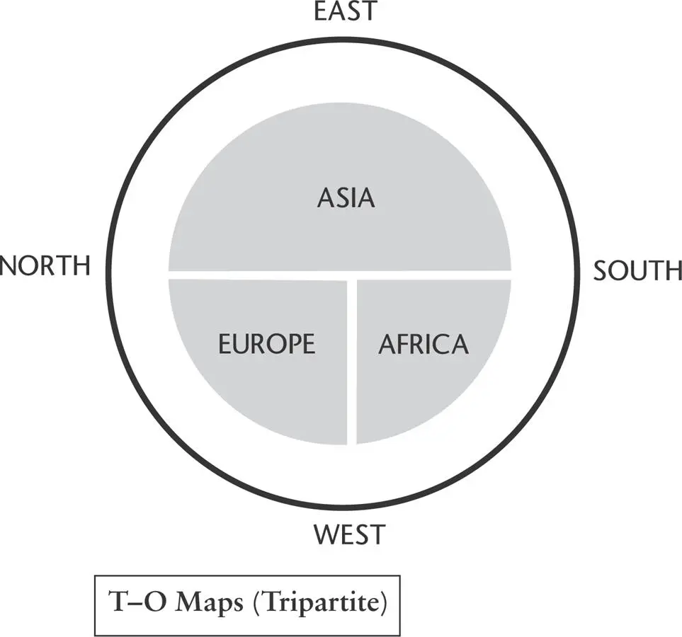
Map 12. These maps illustrated only the habitable portion of the world, as it was known in Roman and medieval times.
The Complex, or Great, maps are perhaps the most famous manifestations of the mappa mundi world maps. The Ebstorf map, made by Gervase of Ebstorf following the T-0 format in the 12th century, was rediscovered in a convent in Ebstorf in 1843. It was painted on 30 goatskins and showed detailed landforms with illustrations from classical antiquity, as well as images from biblical history. The head of Christ is shown at the top – the east – of the map. The original was lost in an allied bombing raid in 1943, but a number of copies still survive.
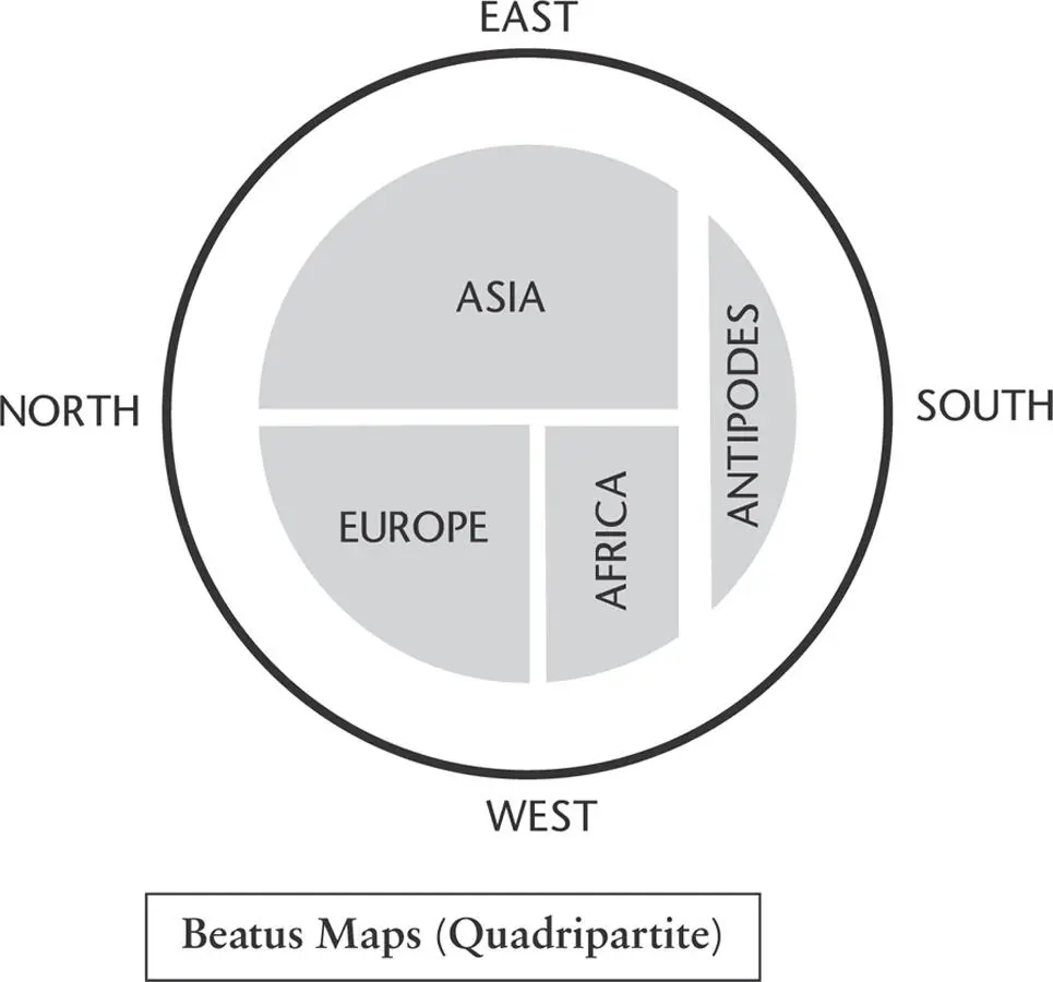
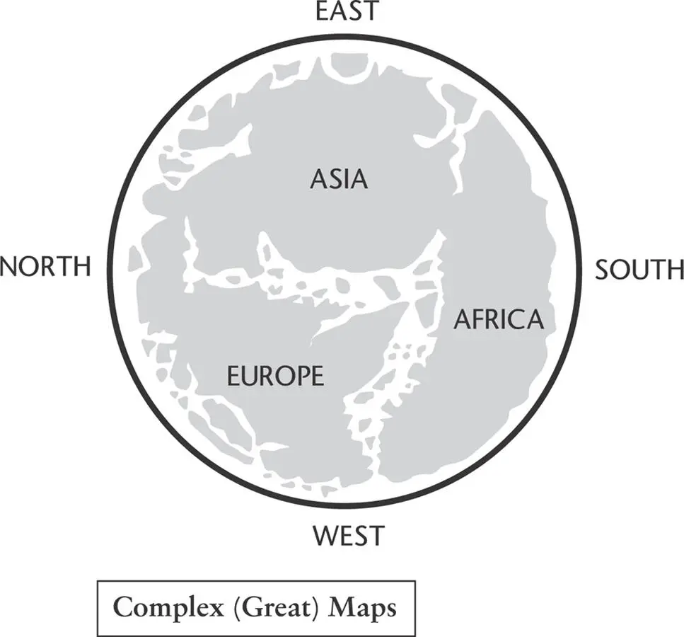
Map 13. These maps represent a kind of amalgam of Zonal and T–O maps and include a fourth, unknown continent, sometimes labelled ‘Antipodes’.
The largest map of this style known to still exist is the Hereford mappa mundi , created around 1300. It is drawn and painted on a single sheet of vellum, 158cm by 133cm, and illustrates fifteen biblical events, five scenes from classical mythology, 420 towns and cities, plus people, plants and animals. Again, east is at the top, with Jerusalem in the centre and the Garden of Eden towards the edge. The map was displayed on the wall of a choir aisle in Hereford Cathedral but was apparently little regarded. In times of trouble – during the Civil War and the Commonwealth in the 17th century, for example – it was hidden beneath the floor of the chantry. During the Second World War the map was hidden again, before being returned to the cathedral in 1946.
A new library to house the map was built with public subscription and large donations from the National Heritage Fund and Paul Getty, which was opened in 1996. *
Despite the cultural revision encouraged by the Christian faith, some classical works still survived across the empire of Charlemagne, which extended across northern and western Europe in the 8th and 9th centuries. Meanwhile, in the Islamic world, a huge amount of classical learning and geography had been preserved by scholars from Baghdad to Córdoba. I call this the Islamic tradition in geography, but it is a very loose description; there was a degree of learning and exchange between this tradition and neighbouring ones; for instance, the Christian tradition and, to a lesser degree, Indian tradition to the east. Al-Mas’udi was a fine proponent of Islamic cartography.
Map 14. These maps show coastal details, mountains, rivers and cities, and may sometimes include figures and stories from history and the Bible.
Al-Mas’udi (896–956 CE), referred to by some as the Arabic Herodotus, was born in 896 CE in Baghdad, descended from Abdullah Ibn Mas’ud, a companion of the Prophet Muhammad. His education took place in and around Baghdad and Basra, learning from well-known and much-admired local literary scholars. He was also influenced by the Mu’tazila school of Islamic theology, which taught that good and evil were not determined by interpretations of revealed scripture, but could be established through ‘unaided reason’, because knowledge was derived from reason, the final arbiter in distinguishing right from wrong.
Al-Mas’udi was thus well equipped to describe and interpret the world he observed in the mid-900s CE and we owe much to the detailed observations he left us as he travelled around the Near East and Persia, North Africa, the Arabian Sea and further afield to the East African coast and to India and Sri Lanka. He took an interest in European affairs and studied the political goings on in Byzantium in particular. In his writings on the latter, in and around the year 947 CE, he uses the name ‘Istanbul’, rather than the usual Constantinople, five centuries before the Ottoman conquest of the city. He was aware of faraway Anglo-Saxon England and the Frankish kingdom with its capital at Paris, listing their kings up to his own time.
Travelling far to the north, he describes the Rus, an account based on personal experience and contacts made on his explorations. He describes the diverse nature of the Rus and the apparent absence of a central authority, with power in the hands of a collection of local rulers instead; they were, as he notes, capable sailors, navigating both their extensive river systems and the open sea. He was well aware that the Black Sea and the Caspian Sea were separate bodies of water, as you can see on his world map.
East of the Rus were the lands of the Kazars, a Khanate made up of a Turkic ruling elite and other diverse ethnic groups who followed various religious traditions. According to Al-Mas’udi, the Kazar rulers converted to Judaism sometime in the 740s CE and encouraged the population to follow their example; what success they had still seems open to debate among today’s scholars.
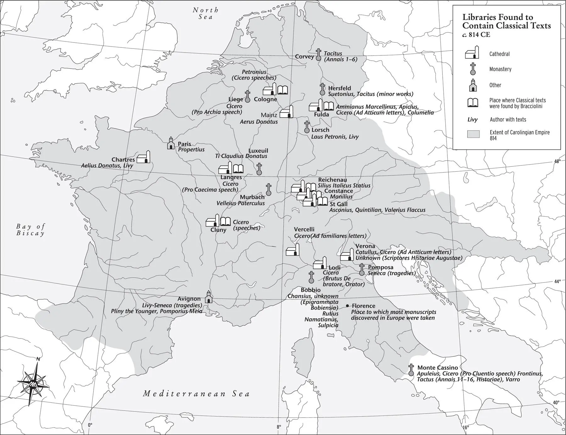
Map 15. Some classical texts survived within the Carolingian Empire and many surviving texts were taken to the city of Florence.
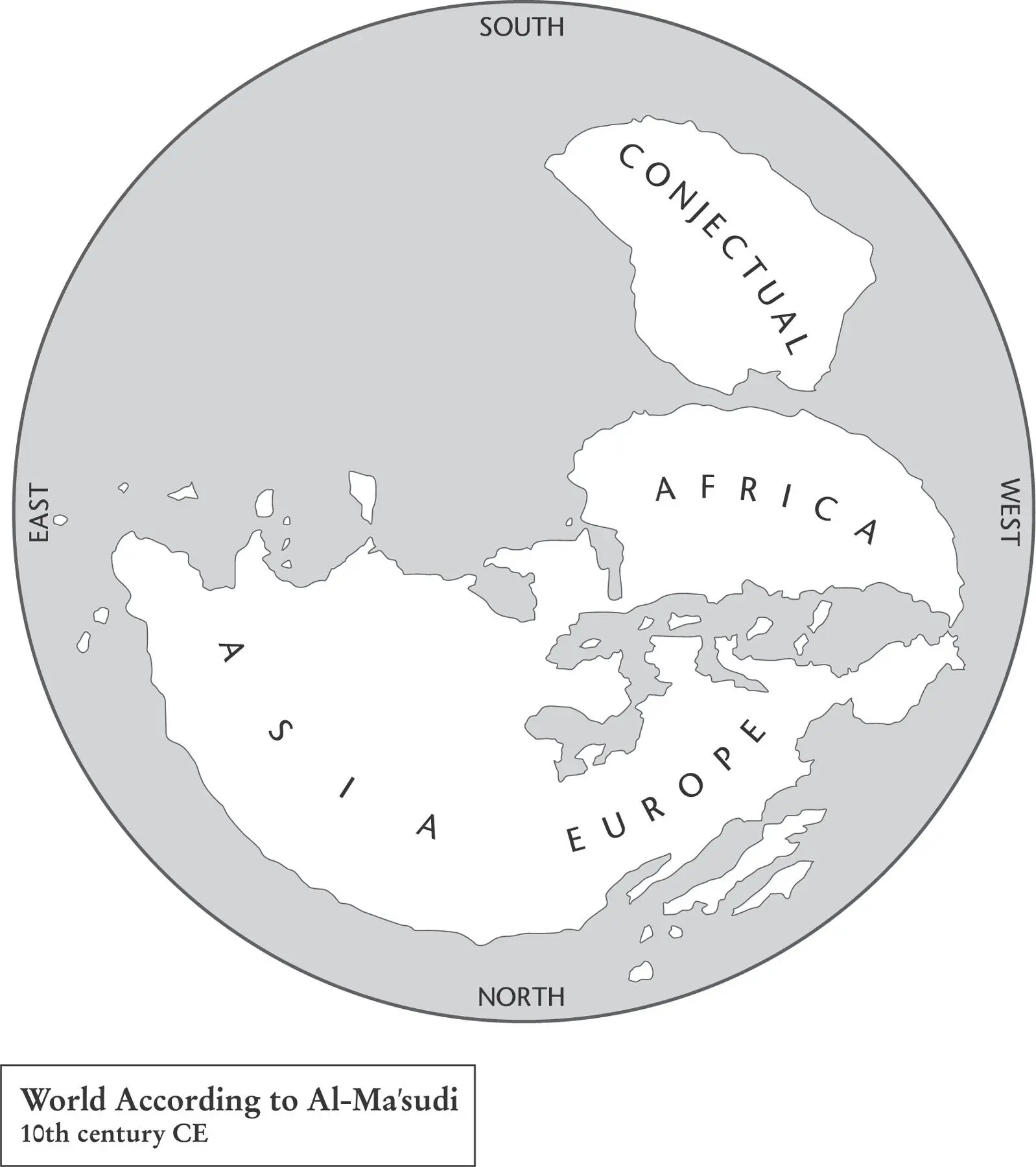
Map 16. Al-Mas’udi was an Arab historian, geographer and explorer. His world map, which followed Arab tradition at the time, viewed the world with south at the top.
Al-Mas’udi went on to describe the Turkic tribes of Central Asia and wrote in some detail on India, its rulers, trade and beliefs. He described China, though in less detail, dwelling at one point on a revolt towards the end of the Tang period, led by a certain Huang Chao, which he describes as leading to a weakening of the dynasty.
Al-Mas’udi was a prolific writer, but the best known of his works is Muruj adh-dhahab wa ma’adin al-jawahir (‘Meadows of Gold and Mines of Gems’), a history that begins with Adam and Eve and takes the reader through the ages to the time of the late Abbasid Caliphate. The same book mentions the story of Khashkhash Ibn Saeed Ibn Aswad, a navigator of al-Andalus (in southern Spain) who sailed across the Atlantic in 889 CE and eventually returned loaded with booty. This story is said to be well known among the people of al-Andalus – a tantalising tradition for succeeding generations of Iberians staring towards that vast western horizon.
Читать дальшеИнтервал:
Закладка:
Похожие книги на «How to Draw a Map»
Представляем Вашему вниманию похожие книги на «How to Draw a Map» списком для выбора. Мы отобрали схожую по названию и смыслу литературу в надежде предоставить читателям больше вариантов отыскать новые, интересные, ещё непрочитанные произведения.


Обсуждение, отзывы о книге «How to Draw a Map» и просто собственные мнения читателей. Оставьте ваши комментарии, напишите, что Вы думаете о произведении, его смысле или главных героях. Укажите что конкретно понравилось, а что нет, и почему Вы так считаете.