Position, Navigation, and Timing Technologies in the 21st Century
Здесь есть возможность читать онлайн «Position, Navigation, and Timing Technologies in the 21st Century» — ознакомительный отрывок электронной книги совершенно бесплатно, а после прочтения отрывка купить полную версию. В некоторых случаях можно слушать аудио, скачать через торрент в формате fb2 и присутствует краткое содержание. Жанр: unrecognised, на английском языке. Описание произведения, (предисловие) а так же отзывы посетителей доступны на портале библиотеки ЛибКат.

- Название:Position, Navigation, and Timing Technologies in the 21st Century
- Автор:
- Жанр:
- Год:неизвестен
- ISBN:нет данных
- Рейтинг книги:5 / 5. Голосов: 1
-
Избранное:Добавить в избранное
- Отзывы:
-
Ваша оценка:
Position, Navigation, and Timing Technologies in the 21st Century: краткое содержание, описание и аннотация
Предлагаем к чтению аннотацию, описание, краткое содержание или предисловие (зависит от того, что написал сам автор книги «Position, Navigation, and Timing Technologies in the 21st Century»). Если вы не нашли необходимую информацию о книге — напишите в комментариях, мы постараемся отыскать её.
Volume 1 of
contains three parts and focuses on the satellite navigation systems, technologies, and engineering and scientific applications. It starts with a historical perspective of GPS development and other related PNT development. Current global and regional navigation satellite systems (GNSS and RNSS), their inter-operability, signal quality monitoring, satellite orbit and time synchronization, and ground- and satellite-based augmentation systems are examined. Recent progresses in satellite navigation receiver technologies and challenges for operations in multipath-rich urban environment, in handling spoofing and interference, and in ensuring PNT integrity are addressed. A section on satellite navigation for engineering and scientific applications finishes off the volume.
Volume 2 of
consists of three parts and addresses PNT using alternative signals and sensors and integrated PNT technologies for consumer and commercial applications. It looks at PNT using various radio signals-of-opportunity, atomic clock, optical, laser, magnetic field, celestial, MEMS and inertial sensors, as well as the concept of navigation from Low-Earth Orbiting (LEO) satellites. GNSS-INS integration, neuroscience of navigation, and animal navigation are also covered. The volume finishes off with a collection of work on contemporary PNT applications such as survey and mobile mapping, precision agriculture, wearable systems, automated driving, train control, commercial unmanned aircraft systems, aviation, and navigation in the unique Arctic environment.
In addition, this text:
Serves as a complete reference and handbook for professionals and students interested in the broad range of PNT subjects Includes chapters that focus on the latest developments in GNSS and other navigation sensors, techniques, and applications Illustrates interconnecting relationships between various types of technologies in order to assure more protected, tough, and accurate PNT
will appeal to all industry professionals, researchers, and academics involved with the science, engineering, and applications of position, navigation, and timing technologies.pnt21book.com
Position, Navigation, and Timing Technologies in the 21st Century — читать онлайн ознакомительный отрывок
Ниже представлен текст книги, разбитый по страницам. Система сохранения места последней прочитанной страницы, позволяет с удобством читать онлайн бесплатно книгу «Position, Navigation, and Timing Technologies in the 21st Century», без необходимости каждый раз заново искать на чём Вы остановились. Поставьте закладку, и сможете в любой момент перейти на страницу, на которой закончили чтение.
Интервал:
Закладка:
Many different techniques have been proposed to enable indoor localization and navigation. The interest in indoor navigation systems is peaking because the crucial sensors necessary for localization have become sufficiently small and inexpensive to enable practical tracking of individuals (who must carry them at all times). A prime example of this is the inertial sensors that are part of inertial measurement units (IMUs) found in smartphones that can aid with localization. However, activity trackers, smart cards, and various types of wearable sensors can also play a crucial role to enable indoor navigation. The challenge today is to exploit these available sensors to achieve indoor tracking with acceptable robustness levels, similar to that demonstrated by GNSS in outdoor locales.
This chapter provides an overview of the state of the‐art in the area of indoor localization and navigation. One can consider localization as an instantaneous process, providing the location of a user or object being tracked at a specific instance of time. In contrast, navigation can be considered as a form of continuous localization, where location estimates must be provided frequently and periodically over time to help a user while they navigate an indoor environment. Tracking can be considered to be similar to navigation, except that the location estimates of the mobile subject are provided not to the user but to some third party that is interested in the location information. For the sake of clarity and brevity, we will mainly use the term localization in the rest of the chapter to represent both instantaneous point estimates and continuous estimates (navigation or tracking), when discussing components and solutions that are relevant for indoor location estimation. We will use the term navigation sparingly, when necessary to discuss the unique aspects of continuous estimation of location.
The rest of the chapter is organized as follows. Section 37.2discusses performance metrics that are necessary to understand, in order to compare and contrast the landscape of indoor localization approaches. Section 37.3provides an easy reference to the key technical terms that are used throughout the rest of the chapter. Section 37.4presents a review of the various signals that can be used to provide tracking in indoor locales, for the purpose of localization. Section 37.5provides an overview of the vast landscape of solutions for indoor localization. Lastly, Section 37.6discusses open research issues and challenges that still remain to be overcome for viable indoor localization.
37.2 Overview of Technical Terms
This section provides a brief overview of some of the commonly used technical terms that are relevant in the field of indoor localization [1].
Absolute and Relative Location.A location determined within the context of a global or large area reference grid obtained from GNSS satellites, markers, or landmarks is referred to as an absolute location. In contrast, relative positions depend on a local frame of reference, for example, coordinates within a small coverage area that represent displacement with respect to a local fixed reference (e.g. a fixed Wi‐Fi access point with known global coordinates).
Anchor and Mobile Nodes.From a networking perspective, nodes in indoor environments that are part of the network and have a stationary (fixed) location are referred to as anchor nodes. In the literature, such nodes may also be referred to as beacons, fixpoints, access points (APs), base stations, or reference nodes. Typically, the coordinates of such anchor nodes are assumed to be known. In contrast, nodes that are part of the network and can move in the indoor environment are referred to as mobile nodes. Such nodes could represent people, robots, or other locomotion‐capable devices (e.g. drones). In general, it is the job of the localization system to determine the (local or global) coordinates of such mobile nodes.
Centralized and Distributed Localization.In a centralized localization architecture, location estimation is carried out at a central server where all anchor and mobile node locations are stored and available to an administrator. The benefits of centralized architectures are simplicity, uniform service to all users, and lower expansion costs as most of the intelligence in the system is concentrated at one location, allowing the mobile and anchor nodes to be lower cost and contain fewer components. In a distributed system, location estimation is carried out on each mobile and anchor node based on local observations. The advantages of a distributed architecture are good system scalability and better guarantees of the user’s privacy (as sensitive location information is not centrally stored, making it less susceptible to being compromised).
Line of Sight (LOS).When a signal can travel via a direct straight path from an emitter to a receiver, it is referred to as LOS transmission. Several localization techniques rely on LOS, for example, time of arrival (ToA)‐based distance measurements with radio frequency (RF) signals. But due to occlusions from walls, furniture, and people, most indoor environments typically induce non‐LOS (NLOS) propagation, which may cause inconsistent time delays at a radio receiver. These delays pose a challenge that can only be tackled by few localization techniques.
Multipath Environment.An environment in which a transmitted signal propagates along multiple paths (echoes), each of which arrives with different path delays at the receiver, is referred to as a multipath environment. Multipath propagation of signals is particularly problematic for time‐based localization methods ( Section 37.5.1.2) because signal paths from different directions degrade the ability to determine the travel time of the direct path. One way to distinguish the direct path from a non‐LOS path is to move the receiver or transmitter. Non‐LOS paths change erratically while in motion, allowing for separation and averaging, while the direct path is directly related to the motion of the object. Thus, averaging over time with a motion‐tracking model is one effective way to mitigate multipath. Another way to overcome multipath is to switch to different frequency channels. Alternatively, radio signals with a large absolute frequency bandwidth such as Ultra‐Wideband (UWB) have been shown to be advantageous for mitigation of multipath fading [2].
Received Signal Strength Indicator (RSSI).Signal attenuation can be used for distance estimation during localization, based on RSSI values. RSSI are observed RSS (received signal strength) values averaged over a specific sampling period and usually specified as received power P Rin decibels. Based on the attenuation model
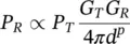
the received signal power or signal strength P Rcan help with the estimation of the distance d of a mobile user or object from the transmitter. In this model, P Tis the transmitted power at the transmitter, G Tand G Rare the antenna gains of the transmitter and receiver, and p is the path loss exponent. The path loss factor p characterizes the rate of attenuation with an increase in distance d . The free space model does not take into account that antennas are usually set up above the ground. In fact, the ground acts as a reflector, and thus the received power differs from that of free space. A mathematical formulation of such a path loss model, also known as open field model, can be found in [3]. Typically, in free space p = 2, whereas for environments with NLOS multipath, p > 2. For indoor environments, the path loss exponent typically takes higher values between 4 and 6. Theoretically, distances estimated from RSSI values to multiple anchor nodes can be used to determine the receiver position by multilateration techniques (see Section 37.5.1for more details). However, interference, multipath propagation, and presence of obstacles and people results in a complex spatial distribution of RSSI values, which can make the estimation of distances using RSSI alone quite inaccurate. Therefore, fingerprinting has become more popular than propagation modeling (see Section 37.5.2for more details).
Читать дальшеИнтервал:
Закладка:
Похожие книги на «Position, Navigation, and Timing Technologies in the 21st Century»
Представляем Вашему вниманию похожие книги на «Position, Navigation, and Timing Technologies in the 21st Century» списком для выбора. Мы отобрали схожую по названию и смыслу литературу в надежде предоставить читателям больше вариантов отыскать новые, интересные, ещё непрочитанные произведения.


Обсуждение, отзывы о книге «Position, Navigation, and Timing Technologies in the 21st Century» и просто собственные мнения читателей. Оставьте ваши комментарии, напишите, что Вы думаете о произведении, его смысле или главных героях. Укажите что конкретно понравилось, а что нет, и почему Вы так считаете.