Urban Remote Sensing
Здесь есть возможность читать онлайн «Urban Remote Sensing» — ознакомительный отрывок электронной книги совершенно бесплатно, а после прочтения отрывка купить полную версию. В некоторых случаях можно слушать аудио, скачать через торрент в формате fb2 и присутствует краткое содержание. Жанр: unrecognised, на английском языке. Описание произведения, (предисловие) а так же отзывы посетителей доступны на портале библиотеки ЛибКат.
- Название:Urban Remote Sensing
- Автор:
- Жанр:
- Год:неизвестен
- ISBN:нет данных
- Рейтинг книги:4 / 5. Голосов: 1
-
Избранное:Добавить в избранное
- Отзывы:
-
Ваша оценка:
Urban Remote Sensing: краткое содержание, описание и аннотация
Предлагаем к чтению аннотацию, описание, краткое содержание или предисловие (зависит от того, что написал сам автор книги «Urban Remote Sensing»). Если вы не нашли необходимую информацию о книге — напишите в комментариях, мы постараемся отыскать её.
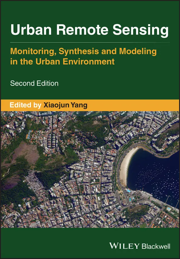
is a state-of-the-art review of the latest progress in the subject. The text examines how evolving innovations in remote sensing allow to deliver the critical information on cities in a timely and cost-effective way to support various urban management activities and the scientific research on urban morphology, socio-environmental dynamics, and sustainability.
Chapters are written by leading scholars from a variety of disciplines including remote sensing, GIS, geography, urban planning, environmental science, and sustainability science, with case studies predominately drawn from North America and Europe.
A review of the essential and emerging research areas in urban remote sensing including sensors, techniques, and applications, especially some critical issues that are shifting the directions in urban remote sensing research. Illustrated in full color throughout, including numerous relevant case studies and extensive discussions of important concepts and cutting-edge technologies to enable clearer understanding for non-technical audiences.
will be of particular interest to upper-division undergraduate and graduate students, researchers and professionals working in the fields of remote sensing, geospatial information, and urban & environmental planning.
Urban Remote Sensing — читать онлайн ознакомительный отрывок
Ниже представлен текст книги, разбитый по страницам. Система сохранения места последней прочитанной страницы, позволяет с удобством читать онлайн бесплатно книгу «Urban Remote Sensing», без необходимости каждый раз заново искать на чём Вы остановились. Поставьте закладку, и сможете в любой момент перейти на страницу, на которой закончили чтение.
Интервал:
Закладка:
Besides, several technical issues have been identified that can improve the use of UAS in urban areas. Specifically, robust navigation systems should be designed to address the signal occlusion and multi‐path effects caused by urban structures; more intelligent autonomous operation modes will need to be developed to account for the issue of urban obstacles; more sophisticated data processing systems should be developed that can help improve the limited performance of currently small, lightweight platforms; and automated path planning systems are urgently needed. There is still much room for the UAS technology to develop and improve for urban remote sensing. A surge of UAS applications in urban studies can be foreseen when regulations have been developed to better integrate UAS into the general airspace and when technologies have been improved for better UAS urban operations.
REFERENCES
1 Adam, E., Mutanga, O. and Rugege, D. (2010) Multispectral and hyperspectral remote sensing for identification and mapping of wetland vegetation: a review. Wetlands Ecology and Management, 18(3), 281–296.
2 Agüera‐Vega, F., Carvajal‐Ramírez, F. and Martínez‐Carricondo, P. (2017) Accuracy of digital surface models and orthophotos derived from unmanned aerial vehicle photogrammetry. Journal of Surveying Engineering, 143(2), 1–10.
3 Aktas, Y., Ozdemir, U., Dereli, Y. et al. (2016) Rapid prototyping of a fixed‐wing VTOL UAV for design testing. Journal of Intelligent & Robotic Systems, 84 (1–4), 639–664.
4 Al Shibli, M. (2015) Towards global unification of UAS standardization: regulations, systems, airworthiness, aerospace control, operation, crew licensing and training. International Journal of Unmanned Systems Engineering, 3(2), 32–74.
5 Alidoost, F. and Arefi, H. (2017) Comparison of UAS‐based photogrammetry software for 3d point cloud generation: a survey over a historical site. ISPRS Annals of Photogrammetry, Remote Sensing & Spatial Information Sciences, 4(4), 55–61.
6 Aljehani, M. and Inoue, M. (2019) Safe map generation after a disaster, assisted by an unmanned aerial vehicle tracking system. IEEJ Transactions on Electrical and Electronic Engineering, 14(2), 271–282.
7 Anderson, K. and Gaston, K.J. (2013) Lightweight unmanned aerial vehicles will revolutionize spatial ecology. Frontiers in Ecology and the Environment, 11(3), 138–146.
8 Ban, Y., Jacob, A. and Gamba, P. (2015) Spaceborne SAR data for global urban mapping at 30 m resolution using a robust urban extractor. ISPRS Journal of Photogrammetry and Remote Sensing, 103, 28–37.
9 Barbasiewicz, A., Widerski, T. and Daliga, K. (2018) The analysis of the accuracy of spatial models using photogrammetric software: Agisoft Photoscan and Pix4D. E3S Web of Conferences, 26, 00012.
10 Benediktsson, J.A., Palmason, J.A. and Sveinsson, J.R. (2005) Classification of hyperspectral data from urban areas based on extended morphological profiles. IEEE Transactions on Geoscience and Remote Sensing, 43(3), 480–491.
11 Berni, J.A.J., Zarco‐Tejada, P., Suárez, L. and Fereres, E. (2009) Thermal and narrowband multispectral remote sensing for vegetation monitoring from an unmanned aerial vehicle. IEEE Transactions on Geoscience and Remote Sensing, 47(3), 722–738.
12 Besada, J.A., Bergesio, L., Campaña, I. et al. (2018) Drone mission definition and implementation for automated infrastructure inspection using airborne sensors. Sensors, 18(4), 1170.
13 Boonpook, W., Tan, Y., Liu, H., Zhao, B. and He, L. (2018) UAV‐based 3d urban environment monitoring. ISPRS Annals of Photogrammetry, Remote Sensing & Spatial Information Sciences, 4(3), 37–43.
14 Boukoberine, M.N., Zhou, Z. and Benbouzid, M. (2019) A critical review on unmanned aerial vehicles power supply and energy management: solutions, strategies, and prospects. Applied Energy, 255, 113823.
15 Brach, M., Cheung‐Wai Chan, J. and Szymański, P. (2019) Accuracy assessment of different photogrammetric software for processing data from low‐cost UAV platforms in forest conditions. iForest ‐ Biogeosciences & Forestry, 12(5), 435–441.
16 Bravo, R.Z.B., Leiras, A. and Cyrino Oliveira, F.L. (2019) The use of UAVs in humanitarian relief: an application of POMDP‐based methodology for finding victims. Production & Operations Management, 28(2), 421–440.
17 Calderón, R., Montes‐Borrego, M., Landa, B.B., Navas‐Cortés, J.A. and Zarco‐Tejada, P. (2014) Detection of downy mildew of opium poppy using high‐resolution multi‐spectral and thermal imagery acquired with an unmanned aerial vehicle. Precision Agriculture, 15(6), 639–661.
18 Campos‐Taberner, M., Romero‐Soriano, A., Gatta, C. et al. (2016) Processing of extremely high‐resolution Lidar and RGB data: outcome of the 2015 IEEE GRSS data fusion contest–part a: 2‐D contest. IEEE Journal of Selected Topics in Applied Earth Observations and Remote Sensing, 9(12), 5547–5559.
19 Card, B.A. (2018) Terror from above: how the commercial unmanned aerial vehicle revolution threatens the US threshold. Air & Space Power Journal, 32(1), 80–96.
20 Chauhan, S.K. (2019) Scholarly output on drone research: a bibliometric study. DESIDOC Journal of Library & Information Technology, 39(2), 117–124.
21 Chiabrando, F., Spanò, A., Sammartano, G. and Losè, L.T. (2017) UAV oblique photogrammetry and lidar data acquisition for 3D documentation of the Hercules Fountain. Virtual Archaeology Review, 8(16), 83.
22 Clothier, R.A. and Walker, R.A. (2015) The safety risk management of unmanned aircraft systems. in Handbook of Unmanned Aerial Vehicles (eds K.P. Valavanis and G.J. Vachtsevanos), pp. 2229–2275. Dordrecht, Netherlands: Springer Science + Business Media B.V.
23 Colomina, I., Blázquez, M., Molina, P. et al. (2008) Towards A New Paradigm for High‐Resolution Low‐Cost Photogrammetryand Remote Sensing. Proceedings of the International Society for Photogrammetry and Remote Sensing (ISPRS) XXI Congress, p. 1201.
24 Colomina, I. and Molina, P. (2014) Unmanned aerial systems for photogrammetry and remote sensing: a review. ISPRS Journal of Photogrammetry and Remote Sensing, 92, 79–97.
25 Cryderman, C., Mah, S.B. and Shufletoski, A. (2014) Evaluation of UAV photogrammetric accuracy for mapping and earthworks computations. Geomatica, 68(4), 309–317.
26 Dalponte, M., Coops, N.C., Bruzzone, L. and Gianelle, D. (2009) Analysis on the use of multiple returns LiDAR data for the estimation of tree stems volume. IEEE Journal of Selected Topics in Applied Earth Observations and Remote Sensing, 2(4), 310–318.
27 Day, D., Weaver, W. and Wilsing, L. (2016) Accuracy of UAS photogrammetry: a comparative evaluation. Photogrammetric Engineering & Remote Sensing, 82 (12), 909–914.
28 Devriendt, L. and Bonne, J. (2014) UAS Mapping as an alternative for land surveying techniques? The International Archives of Photogrammetry, Remote Sensing & Spatial Information Sciences, 40(3), 39.
29 Ding, D., Wang, Y., Xiao, Y. and Han, Z. (2018) Low‐altitude Fixed‐wing UAV Obstacle Recognition Based on Deep Learning. 2018 IEEE CSAA Guidance, Navigation and Control Conference (CGNCC), CSAA Guidance, Navigation and Control Conference (CGNCC), 2018 IEEE, pp. 1–6.
30 Dong, X., Ren, Y., Meng, J. et al. (2018) Design and Implementation of Multi‐rotor UAV Power Relay Platform. 2018 2nd IEEE Advanced Information Management, Communicates, Electronic and Automation Control Conference (IMCEC), 2018 2nd IEEE, pp. 1142–1146.
31 Erenoglu, R.C., Erenoglu, O. and Arslan, N. (2018) Accuracy assessment of low cost UAV based city modelling for urban planning. Tehnicki Vjesnik‐Technical Gazette, 25 (6), 1708–1714.
32 Federal Aviation Administration (2013) Pack safe: lithiumion and lithium metal batteries, spare (uninstalled). Available: https://www.faa.gov/hazmat/packsafe/more_info/?hazmat=7(accessed 20 June 2018).
Читать дальшеИнтервал:
Закладка:
Похожие книги на «Urban Remote Sensing»
Представляем Вашему вниманию похожие книги на «Urban Remote Sensing» списком для выбора. Мы отобрали схожую по названию и смыслу литературу в надежде предоставить читателям больше вариантов отыскать новые, интересные, ещё непрочитанные произведения.


Обсуждение, отзывы о книге «Urban Remote Sensing» и просто собственные мнения читателей. Оставьте ваши комментарии, напишите, что Вы думаете о произведении, его смысле или главных героях. Укажите что конкретно понравилось, а что нет, и почему Вы так считаете.