Urban Remote Sensing
Здесь есть возможность читать онлайн «Urban Remote Sensing» — ознакомительный отрывок электронной книги совершенно бесплатно, а после прочтения отрывка купить полную версию. В некоторых случаях можно слушать аудио, скачать через торрент в формате fb2 и присутствует краткое содержание. Жанр: unrecognised, на английском языке. Описание произведения, (предисловие) а так же отзывы посетителей доступны на портале библиотеки ЛибКат.
- Название:Urban Remote Sensing
- Автор:
- Жанр:
- Год:неизвестен
- ISBN:нет данных
- Рейтинг книги:4 / 5. Голосов: 1
-
Избранное:Добавить в избранное
- Отзывы:
-
Ваша оценка:
Urban Remote Sensing: краткое содержание, описание и аннотация
Предлагаем к чтению аннотацию, описание, краткое содержание или предисловие (зависит от того, что написал сам автор книги «Urban Remote Sensing»). Если вы не нашли необходимую информацию о книге — напишите в комментариях, мы постараемся отыскать её.
is a state-of-the-art review of the latest progress in the subject. The text examines how evolving innovations in remote sensing allow to deliver the critical information on cities in a timely and cost-effective way to support various urban management activities and the scientific research on urban morphology, socio-environmental dynamics, and sustainability.
Chapters are written by leading scholars from a variety of disciplines including remote sensing, GIS, geography, urban planning, environmental science, and sustainability science, with case studies predominately drawn from North America and Europe.
A review of the essential and emerging research areas in urban remote sensing including sensors, techniques, and applications, especially some critical issues that are shifting the directions in urban remote sensing research. Illustrated in full color throughout, including numerous relevant case studies and extensive discussions of important concepts and cutting-edge technologies to enable clearer understanding for non-technical audiences.
will be of particular interest to upper-division undergraduate and graduate students, researchers and professionals working in the fields of remote sensing, geospatial information, and urban & environmental planning.
Urban Remote Sensing — читать онлайн ознакомительный отрывок
Ниже представлен текст книги, разбитый по страницам. Система сохранения места последней прочитанной страницы, позволяет с удобством читать онлайн бесплатно книгу «Urban Remote Sensing», без необходимости каждый раз заново искать на чём Вы остановились. Поставьте закладку, и сможете в любой момент перейти на страницу, на которой закончили чтение.
Интервал:
Закладка:
3.4.4 SMART CITIES
Smart city is an idea to integrate technologies to support a healthy, safe, and convenient way of urban living. In the realization of smart cities, UAS can play a role in monitoring, detecting, and predicting anomalies in urban environments and therefore safeguarding humans. Because implementing real UAS experiments in urban environments is risky concerning safety and privacy, simulation may be needed to test and evaluate the performance of UAS in advance. For example, Pannozzi et al. (2019) created a simulated 3D urban environment with the aid of OpenStreetMap (OSM) volunteered geographic information for the city of Turin, Italy. The virtual city model considers wind, battery, and motor failure. Under this environment, they have successfully achieved autonomous and semi‐autonomous UAS missions using the PX4 package, and a full manual piloting flight using the Parrot‐Sphinx package. Based on their test results, they concluded UAS can be used in traffic and crowd monitoring, 3D building mapping, and urban growth to better understand urban dynamics.
3.5 CASE STUDY: MAPPING AN URBAN RECREATION COMPLEX WITH UAS
To better understand the general workflow for UAS data processing, a case study is presented here. This project involved the use of a small UAS to generate 2D and 3D mapping data over a relatively small urban recreation complex through the photogrammetry software package called Agisoft Metashape . For this project, researchers used a small UAS ( DJI Phantom 4 Pro ) to obtain oblique imagery of an urban recreation complex owned by the City of Auburn, Alabama, USA, and created 2D and 3D mapping data. The workflow used for this project largely followed the same procedure outlined by Nex and Remondino (2014). Since the researchers were interested in generating 3D outputs from the UAS imagery, a flight plan was designed as a double‐grid pattern that would allow the UAS to maintain an oblique camera orientation during the image collection process, which allowed the facades of the buildings and other tall features to be better captured in the imagery. Figure 3.2a depicts the AOI for the mapping mission and Figure 3.2b illustrates the double grid flight plan overlaid on the AoI. This project used the application Pix4D Capture ( pix4d.com/product/pix4dcapture) to design and operationalize the UAS image collection flight plan. There are numerous flight planning applications available that have the same core functionality of Pix4D Capture but offer minor differences in user customization and interface design. Some examples of other similar flight planning applications include DroneDeploy [Flight App for Business] ( www.dronedeploy.com/product/mobile), Map Pilot by Maps Made Easy ( www.mapsmadeeasy.com), DJI Ground Station Pro ( www.dji.com/ground‐station‐pro), and Litchi ( www.flylitchi.com).
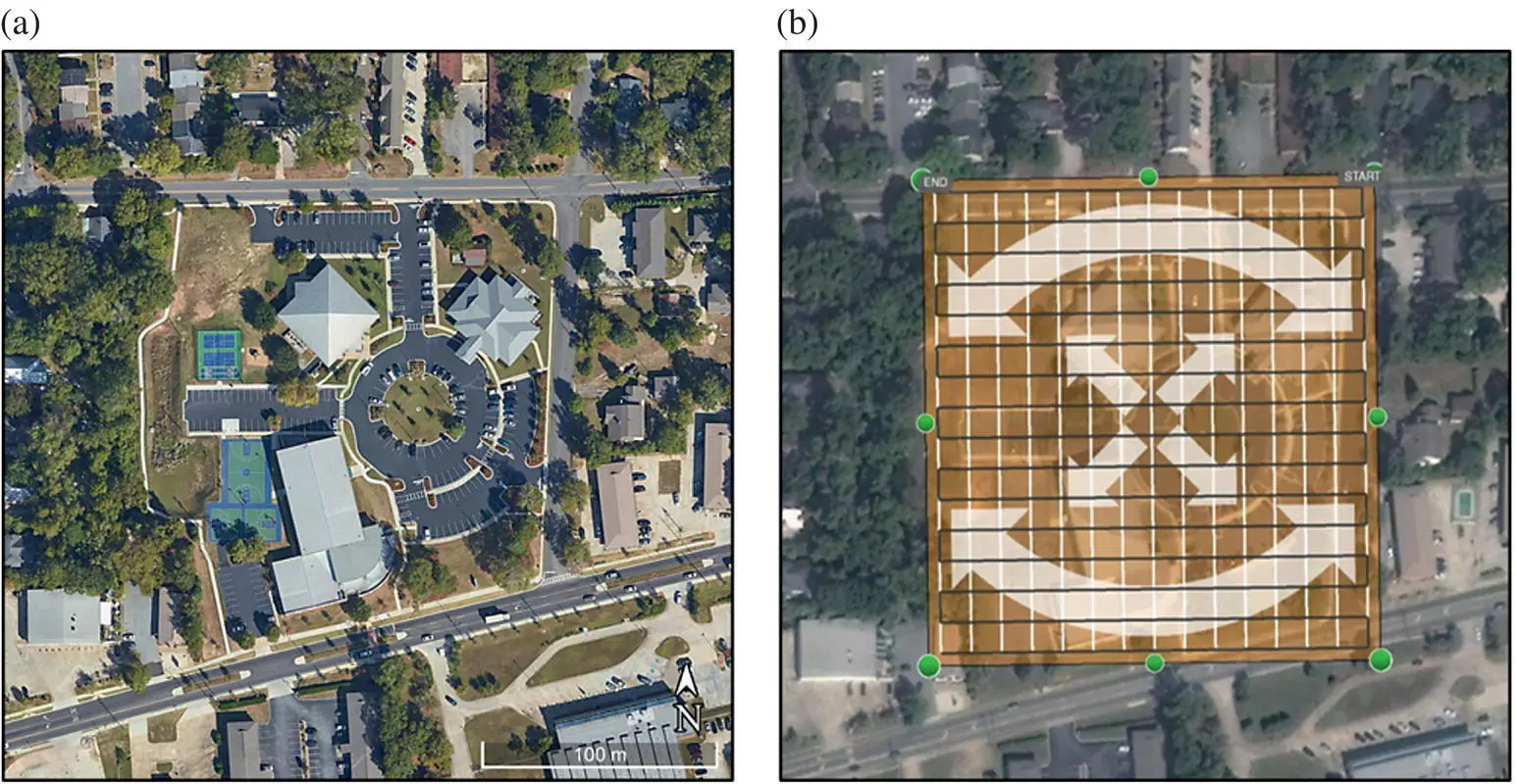
FIGURE 3.2 (a) An aerial view of the Urban Recreation Complex. (b) A flight plan design for UAS data collection. Since the UAS uses oblique camera orientation when capturing images, it needs to flight two grid patterns to capture all four sides of every feature.
To create the desired 3D data outputs (namely, point cloud and a textured model) for this project the user‐defined flight parameters for the flight plan included a flight altitude of 35 m above ground level (AGL), a frontal image overlap of 85%, and side image overlap of 80%, and an oblique camera orientation of 65° (i.e. 90° is nadir orientation). The flight altitude of 35 m allowed the UAS to fly the double‐grid pattern at a low altitude, leading to high‐resolution images to be collected. As previously mentioned, these flight parameters are highly contingent on the specific context that a UAS operator is conducting flights for so their settings can vary from one project to another. For this urban recreation complex mapping project, there were no obstacles of concern above approximately 30 m AGL, so 35 m was a safe flying altitude that would also allow imagery to be acquired at very high resolution. The benefits of this low flight altitude can be seen in the increased quality of resolution in the aerial images, thus leading to a much finer resolution in the geospatial outputs. However, such a low flight altitude does require a much longer flight time than flying at a higher altitude.
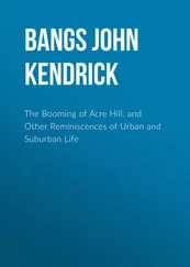
After the flights were flown to collect the oblique imagery, the data were then organized and prepared for processing into 2D and 3D photogrammetric outputs. With a photogrammetry software package called Agisoft Metashape , the images were used to generate 3‐D point cloud data that were then georeferenced and can be further used to derive a DSM. Point cloud data consist of points with geographic location and thematic information, derived from commonly matched pixels in the input imagery. Figure 3.3illustrates the relationship between the input aerial images and the 3D point cloud. With the point cloud data, a DSM can be created which is required to rectify the input images that are used to generate the final combined orthophoto. The process of rectification uses the DSM to remove geometric distortions from the aerial imagery due to relief displacement. In addition to generating DSMs and rectified orthophotos with the point cloud data, users can also generate tiled 3D models that are interpolated point clouds that depict a smooth surface. Figure 3.4a shows the point cloud output for a building located in the urban recreation complex. Figure 3.4b illustrates a tiled model of the same building generated using the point cloud data. Figure 3.5a depicts a DSM generated using the Dense Point Cloud as input to determine elevational values. Figure 3.5b shows the rectified orthophoto generated from the original input images and the DSM.
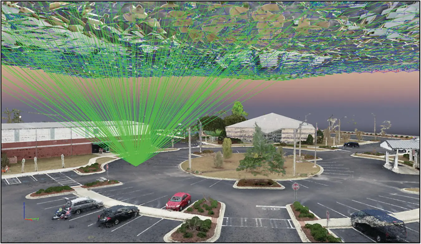
FIGURE 3.3 An example of the 3D point cloud of the urban recreation complex with input aerial images aligned overhead. Each point in the point cloud was generated from commonly matched pixels in the input images, as represented by the green lines connecting to a single point.
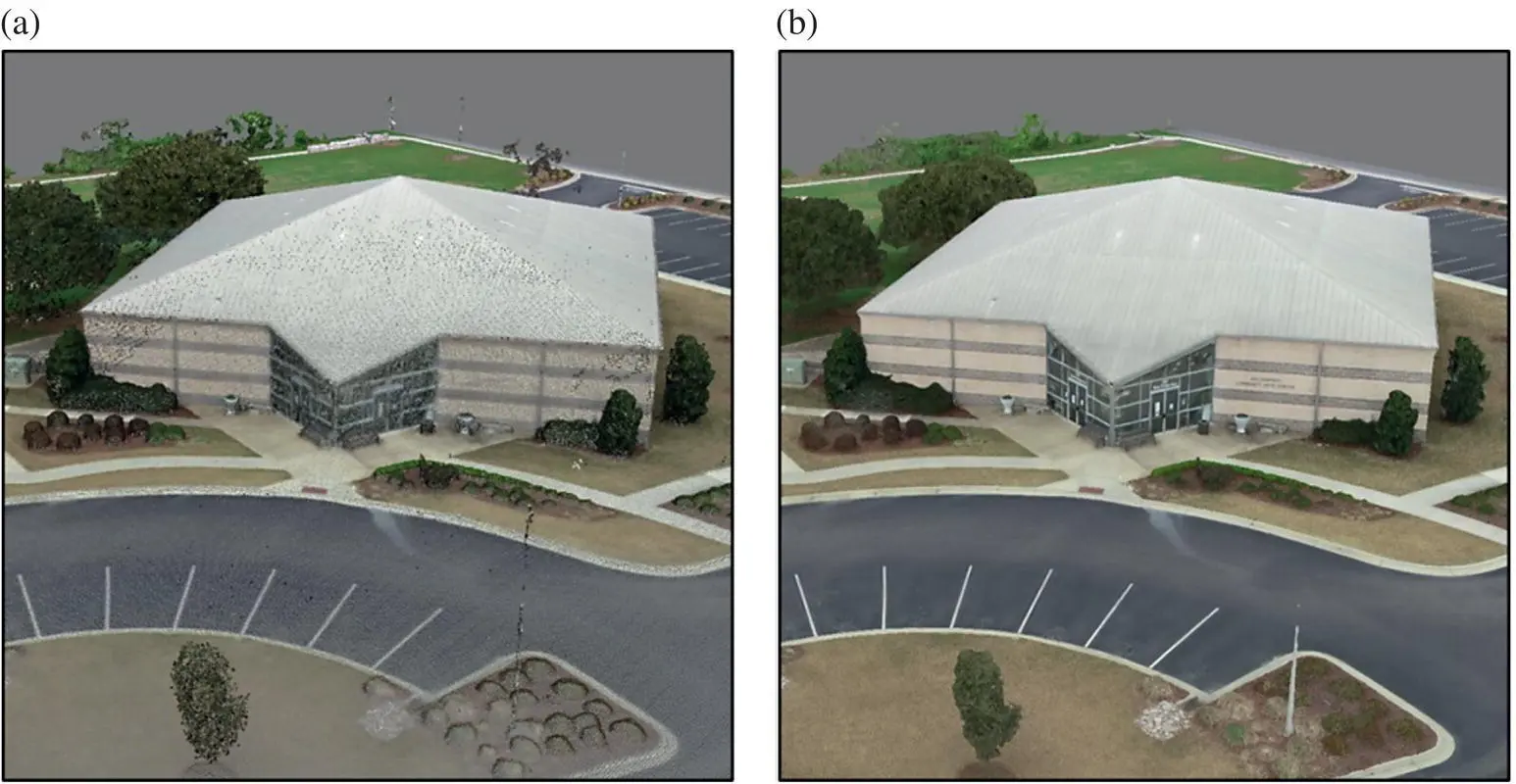
FIGURE 3.4 (a) Point cloud data of urban recreation building. (b) 3D tiled model of urban recreation building. The 3D point cloud data were used by a photogrammetry software package to generate a smooth‐surfaced “tiled model” through interpolation of the 3D points.
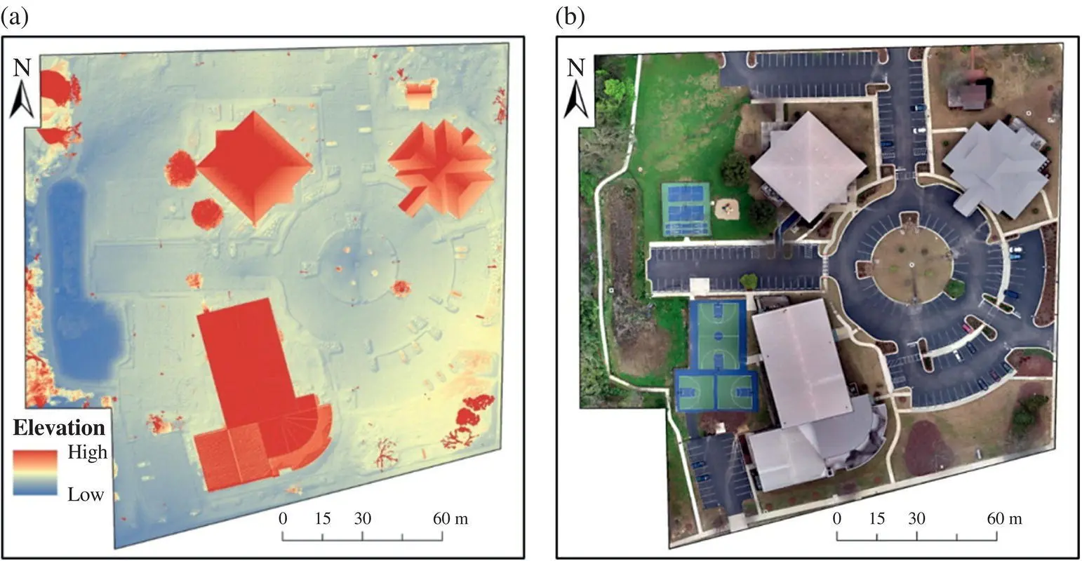
FIGURE 3.5 (a) A digital surface model (DSM) of the urban recreation complex depicting elevation values. (b) An orthophoto of the urban recreation complex. The DSM was generated by a photogrammetry software package. It was further used to orthorectify aerial images by removing geometric distortions caused by relief displacement.
3.6 MAJOR CHALLENGES AND POSSIBLE SOLUTIONS
3.6.1 REGULATORY AND LEGAL CHALLENGES
The use of UAS for aerial remote sensing presents significant opportunities for urban applications. However, these applications can be constrained by the regulatory framework and legal jurisdictions within which those operations are conducted. The rapid development of UAS technology in recent years has led to a present regulatory challenge facing government officials. How do we allow UAS technology to become an integral tool in a wide variety of industries while also not creating new problems related to the increased presence of UAS in civil airspace? Different countries/states/provinces/regions have UAS regulations that are often structured with similar intentions, especially if they are regional neighbors. However, there is still a wide discrepancy in the specific details of these regulations from one regulatory body to another. Although the specific details of one country’s UAS regulations may differ from the rest, there are many common topics that the regulations are focused on. These regulatory topics generally include restrictions on flight altitude, max UAS speed during flight, which airspaces UAS can be operated within, design limitations of UAS platforms, and other potential risks posed to the public (Al Shibli, 2015). The use of UAS in civil airspace presents a host of potential risks and problems, such as surveillance and privacy concerns (West and Bowman, 2016), noise disturbances to the public (Wallace et al., 2018), and the general lack of universally standardized safety features in contemporary UAS models (Plioutsias et al., 2018). For these reasons, it is highly advised for UAS operators to look at the regulations from the specific country before conducting any aerial operations.
Читать дальшеИнтервал:
Закладка:
Похожие книги на «Urban Remote Sensing»
Представляем Вашему вниманию похожие книги на «Urban Remote Sensing» списком для выбора. Мы отобрали схожую по названию и смыслу литературу в надежде предоставить читателям больше вариантов отыскать новые, интересные, ещё непрочитанные произведения.


Обсуждение, отзывы о книге «Urban Remote Sensing» и просто собственные мнения читателей. Оставьте ваши комментарии, напишите, что Вы думаете о произведении, его смысле или главных героях. Укажите что конкретно понравилось, а что нет, и почему Вы так считаете.