Wetland Carbon and Environmental Management
Здесь есть возможность читать онлайн «Wetland Carbon and Environmental Management» — ознакомительный отрывок электронной книги совершенно бесплатно, а после прочтения отрывка купить полную версию. В некоторых случаях можно слушать аудио, скачать через торрент в формате fb2 и присутствует краткое содержание. Жанр: unrecognised, на английском языке. Описание произведения, (предисловие) а так же отзывы посетителей доступны на портале библиотеки ЛибКат.
- Название:Wetland Carbon and Environmental Management
- Автор:
- Жанр:
- Год:неизвестен
- ISBN:нет данных
- Рейтинг книги:4 / 5. Голосов: 1
-
Избранное:Добавить в избранное
- Отзывы:
-
Ваша оценка:
Wetland Carbon and Environmental Management: краткое содержание, описание и аннотация
Предлагаем к чтению аннотацию, описание, краткое содержание или предисловие (зависит от того, что написал сам автор книги «Wetland Carbon and Environmental Management»). Если вы не нашли необходимую информацию о книге — напишите в комментариях, мы постараемся отыскать её.
Wetland Carbon and Environmental Management Volume highlights include:
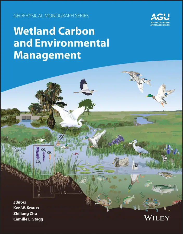
Overview of carbon storage in the landscape Introduction to wetland management practices Comparisons of natural, managed, and converted wetlands Impact of wetland management on carbon storage or loss Techniques for scientific assessment of wetland carbon processes Case studies covering tropical, coastal, inland, and northern wetlands Primer for carbon offset trading programs and how wetlands might contribute The American Geophysical Union promotes discovery in Earth and space science for the benefit of humanity. Its publications disseminate scientific knowledge and provide resources for researchers, students, and professionals.
Wetland Carbon and Environmental Management — читать онлайн ознакомительный отрывок
Ниже представлен текст книги, разбитый по страницам. Система сохранения места последней прочитанной страницы, позволяет с удобством читать онлайн бесплатно книгу «Wetland Carbon and Environmental Management», без необходимости каждый раз заново искать на чём Вы остановились. Поставьте закладку, и сможете в любой момент перейти на страницу, на которой закончили чтение.
Интервал:
Закладка:
The key uncertainties on tropical peatland C stocks and fluxes relate to extent, peat depth, rate of peat decomposition, and ecosystem functioning (Lawson et al., 2015; FAO, 2020). Even in the best studied tropical peatland area of SE Asia the actual extent and depth are uncertain (Vernimmen et al., 2020). This uncertainty is even more acute in Africa, where the recent study of Congo peatlands resulted in a 29% increase in known global tropical area (Dargie et al., 2017). Remote‐sensing techniques combined with ground‐truthing and field measurement campaigns are needed to improve mapping and monitoring of tropical peatlands and will also provide the basis for assessment of peatland condition and likely improvement of understanding of their role in the global C cycle (FAO, 2020). We estimate that tropical peatlands contain 8.5–9.6 PgC in aboveground biomass, 69–129 PgC in organic soil carbon (Dargie et al., 2017), and 77.5–138.6 PgC for total carbon stocks.
1.4.4. High‐Latitude Wetlands
The largest extent of peatlands and wetlands globally are in Boreal and Arctic biomes (here defined as >50°N latitude) where waterlogging and low soil temperatures promotes the accumulation of organic matter (Gorham, 1991). Peatlands >50°N latitude cover ca. 3.3 M km 2, which is >70% of the global peatland area (Hugelius et al., 2020) These northern peatlands have been expanding throughout the Holocene, sequestering C into peat deposits and acting as a sink for atmospheric carbon (Smith, 2004; MacDonald et al., 2006; Brovkin et al., 2016). Peatlands are a type of wetland defined by an accumulation of peat (organic soil) at the surface, usually to a thickness of at least 30 or 40 cm (Joosten & Clarke, 2002). Gorham (1991) provided an extensive review of northern peatlands and made a benchmark carbon stock estimate of 455 PgC in the northern high‐latitude region of the world. Over broad spatial scales, peatland initiation is favored by relatively low temperature and high precipitation (Kivinen & Pakarinen, 1981). At local scales, topography and substrate permeability are the main controls on soil water retention (Loisel et al., 2017).
The two main processes of peatland formation (and expansion) are paludification or terrestrialization. Paludification is the most common form of northern peatland formation and involves initiation and expansion of peatlands into other established terrestrial ecosystems (such as poorly drained forests) and terrestrialization is peatland formation due to gradual in‐filling of water bodies (Kuhry & Turunen, 2006). While peatland initiation is favored by wet and cold conditions, the vertical growth and carbon accumulation rate of peat in established peatlands is favored by long growing seasons and high incoming photosynthetically active radiation, so that ecosystem productivity seems more important than decomposition rates for the rate of long‐term carbon accumulation (Charman et al., 2013). Over the past seven millennia, the mean net carbon accumulation rate in northern peatlands has been slightly above 10 g C/m 2/yr, with present day flux measurements indicating a mean sink strength of around 30 g C/m 2/yr (Yu et al., 2012). Northern peatlands and wetlands are a sink for atmospheric carbon, and this sink is expected to remain or grow in coming decades (Frolking et al., 2011; Chaudhary et al., 2020). However, it has been shown that the sink strength may saturate (Gallego‐Sala et al., 2018) or that peat growth may partly be offset by disturbances, including higher fire frequency (Turetsky et al., 2015), drought (Fenner and Freeman, 2011), and thawing of permafrost (Schuur et al., 2015).
A recent study presented an estimate of northern peatland stocks of 415±150 (min/max) Pg C, of which 185±66 PgC is in permafrost peatlands (calculated for >50°N latitude from Hugelius et al., 2020). This estimate is in line with most earlier studies and is based on harmonized soil maps and >7000 field observations. A fully consistent estimate of northern peatland extent and carbon stocks has long been lacking (Loisel et al., 2017; Yu et al., 2014). The large spread in estimates is due to a lack of unified methods or maps, as well as different definitions used. Studies in recent decades have quantified northern peat C stocks ranging from 270 to 604 PgC, but numbers of 400 to 500 Pg are most commonly used and cited (Yu et al., 2014; Loisel et al., 2017). The estimates are similar in that they all rely on combining data from peat cores (either peat depth or historical peat accumulation) with areal estimates of present day peatland coverage. In most cases however, these studies have not defined a specific lower latitude for the spatial extent, and thus include peat C stored south of >50°N latitude. Most recent studies have used areal estimates for northern peatland extent from Gorham (1991), 3.42 × 10 6km 2, or from Joostens and Clark (2002), 3.46 × 10 6km 2. These areal estimates are primarily derived from combining various national inventories of peat resources, which are not available as maps. Global soil or peatland map products that have been used to support broad‐scale modeling, such as WISE30sec or PEATMAP (Batjes, 2016; Xu et al., 2018) show significantly lower coverage of northern peatlands (< 3 ×10 6km 2). Within the northern permafrost region, more detailed regional soil maps have been used to estimate peatland carbon stocks of ca 300±50 PgC, of which ca 150±30 Pg is in permafrost (Hugelius et al., 2014).
Globally, mineral wetland soils cover an estimated 2.3 × 10 6km 2and store ca. 50 PgC (Bridgham et al., 2006). There is no specific estimate for Boreal and Arctic biomes, but spatial analyses of the WISE30sec database (Batjes, 2016) suggest that ca. half of this area and stock is located >50°N. Vegetation C stocks in northern wetlands is usually a small fraction of total ecosystem carbon. In forested northern wetlands, vegetation C is usually 5–10 kg C m –2, but in open wetland systems it rarely exceeds 1–2 kg C/m 2(Alexeyev & Birdsey, 1998). With a total Boreal and Arctic wetland area of 4.5 × 10 6km 2, of which a quarter is forested, the total vegetation carbon stock is estimated to ca. 10–15 PgC. We estimate that total soil organic carbon stocks in wetlands north of 50° latitude ranges between 400–500 PgC. Defining high‐latitude wetlands to include all permafrost zones (continuous, discontinuous, sporadic) would give an estimate of up to 1672 PgC, which 1466 PgC is in perennially frozen soils and deposits, i.e., Yedoma (Tarnocai et al., 2009).
1.4.5. Temperate Wetlands
Temperate wetlands include those found in the conterminous United States, Europe, India, Asia, Japan, and other temperate regions. These wetlands are generally classified into mineral‐soil based (“freshwater mineral‐soil wetlands”) or peat‐based organic soil wetlands (Mitsch & Gosselink, 2007). Examples of temperate mineral‐soil wetlands include freshwater swamps, freshwater marshes, and riparian forests (Mitsch & Gosselink, 2015). Total global areal estimate for mineral‐soil temperate wetlands is 2,315,000 km 2(Bridgham et al., 2006). Total carbon stock estimates for freshwater mineral‐soil wetlands are 31–46 PgC (Kolka et al., 2018; Bridgham et al., 2006). Peat‐accumulating wetland soils (histosols) occupy 1.3% of the global land area but store approximately 30% of the world’s soil organic carbon (Trettin et al., 2003; Bridgham et al., 2006). Through sequestration and storage, peatlands provide critical ecosystem services that help regulate global climate and mitigate climate change (McLeod et al., 2011). However, these systems are shrinking due to human land‐use modifications and sea level rise (McLeod et al., 2011; Pendleton et al., 2012).
Most peatlands (>50%) occur in northern latitudes; the southern limits of these regions coincide approximately 30–40°N latitude in North America and 50°N latitude in Europe and Asia (Craft et al., 2008; Tarnocai & Stolbovoy, 2006; Yu et al., 2011), where low temperatures are partially responsible for inhibiting organic matter decomposition and limited productivity (Clymo, 1984; Roulet et al., 2007). In the case of wetlands in more temperate or subtropical climates, this temperature effect seems to be more complex and less understood. In a study of temperate freshwater peatlands across a latitudinal gradient in the US, Craft et al. (2008) found that, like terrestrial ecosystems, organic C accumulation in freshwater peatlands is linked to climate through the effects of temperature. Higher C accumulation was measured in cooler and moister climates with lower accumulation in warmer and drier climates. However, other factors, such as species composition (Stricker et al., 2019) also play an important role in the variability in C sequestration and storage. Temperate peatlands in North America cover 861,000 km 2(compared to 3,443,000 km 2peatland coverage globally) (Bridgham et al., 2006; Kolka et al., 2018). In the United States, temperate peatlands cover an area of approximately 93,000 km 2and can be found from Minnesota to Florida and California (Brigham et al., 2006; Craft et al., 2008; Reddy et al., 2015; Drexler et al., 2017). In the southeastern US, temperate peatlands once covered approximately 15,000 km 2(Richardson et al., 2003). In the Southeast US, forested peatlands include peat swamps and shrub‐scrub and pond pine ( Pinus serotina )‐dominated bogs referred to as pocosins (Richardson, 1983). In North Carolina alone, peatlands covered 9,079 km 2of the coastal plain, but by 1979 only 2,810 km 2remained (Richardson, 1983). Much of the landscape was deforested at the beginning of the twentieth century, and in the 1970–1980s large canals and ditches were built to facilitate agriculture (Carter, 1975).
Читать дальшеИнтервал:
Закладка:
Похожие книги на «Wetland Carbon and Environmental Management»
Представляем Вашему вниманию похожие книги на «Wetland Carbon and Environmental Management» списком для выбора. Мы отобрали схожую по названию и смыслу литературу в надежде предоставить читателям больше вариантов отыскать новые, интересные, ещё непрочитанные произведения.


Обсуждение, отзывы о книге «Wetland Carbon and Environmental Management» и просто собственные мнения читателей. Оставьте ваши комментарии, напишите, что Вы думаете о произведении, его смысле или главных героях. Укажите что конкретно понравилось, а что нет, и почему Вы так считаете.