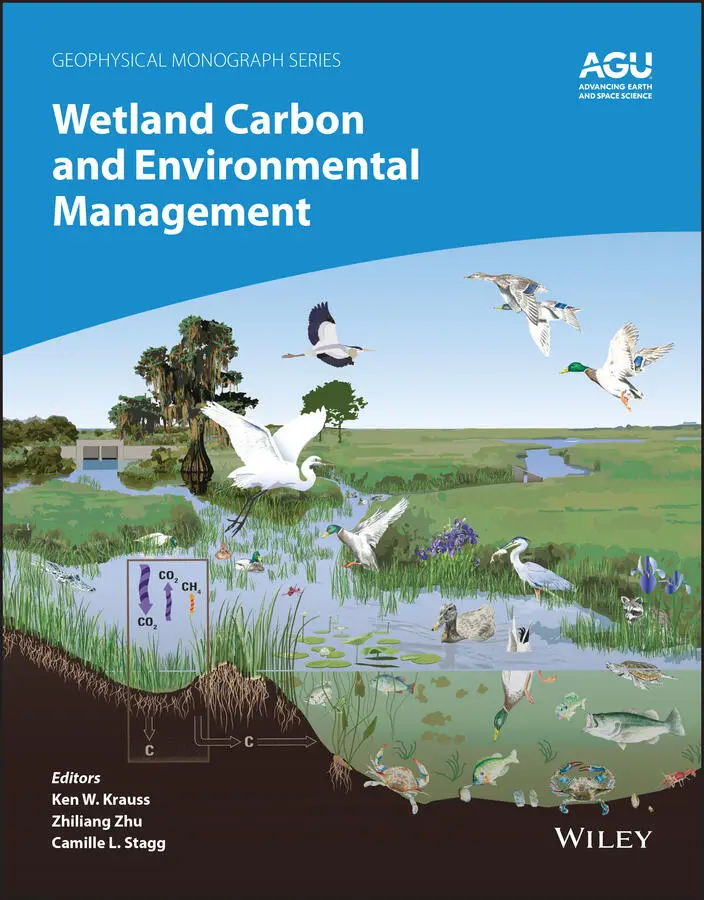
Wetland Carbon and Environmental Management
Здесь есть возможность читать онлайн «Wetland Carbon and Environmental Management» — ознакомительный отрывок электронной книги совершенно бесплатно, а после прочтения отрывка купить полную версию. В некоторых случаях можно слушать аудио, скачать через торрент в формате fb2 и присутствует краткое содержание. Жанр: unrecognised, на английском языке. Описание произведения, (предисловие) а так же отзывы посетителей доступны на портале библиотеки ЛибКат.
- Название:Wetland Carbon and Environmental Management
- Автор:
- Жанр:
- Год:неизвестен
- ISBN:нет данных
- Рейтинг книги:4 / 5. Голосов: 1
-
Избранное:Добавить в избранное
- Отзывы:
-
Ваша оценка:
Wetland Carbon and Environmental Management: краткое содержание, описание и аннотация
Предлагаем к чтению аннотацию, описание, краткое содержание или предисловие (зависит от того, что написал сам автор книги «Wetland Carbon and Environmental Management»). Если вы не нашли необходимую информацию о книге — напишите в комментариях, мы постараемся отыскать её.
Wetland Carbon and Environmental Management Volume highlights include:
Overview of carbon storage in the landscape Introduction to wetland management practices Comparisons of natural, managed, and converted wetlands Impact of wetland management on carbon storage or loss Techniques for scientific assessment of wetland carbon processes Case studies covering tropical, coastal, inland, and northern wetlands Primer for carbon offset trading programs and how wetlands might contribute The American Geophysical Union promotes discovery in Earth and space science for the benefit of humanity. Its publications disseminate scientific knowledge and provide resources for researchers, students, and professionals.
Wetland Carbon and Environmental Management — читать онлайн ознакомительный отрывок
Ниже представлен текст книги, разбитый по страницам. Система сохранения места последней прочитанной страницы, позволяет с удобством читать онлайн бесплатно книгу «Wetland Carbon and Environmental Management», без необходимости каждый раз заново искать на чём Вы остановились. Поставьте закладку, и сможете в любой момент перейти на страницу, на которой закончили чтение.
Интервал:
Закладка:
Global inventories of land‐use related emissions have not considered the impact of wetland drainage outside of recent drainage in Southeast Asia (Pongratz et al., 2018). Drainage of peat swamps in Indonesia alone are estimated to have emitted 6 PgC from 1850–2015 (Houghton and Nassikas, 2017). Peat drainage in this region still occurs at a rapid pace, i.e., 14,500 km 2of peat swamp forest have been converted to oil palm and pulpwood plantations between 2000–2010 (Page and Hooijer, 2016). Separate accounting efforts using geospatial data and emission factors have estimated that >250,000 Mkm 2of organic soiled wetlands were drained for agriculture globally, leading to a CO 2release of 0.078 Pg/yr, more than one‐fourth of all land‐use CO 2emissions (Tubiello et al., 2016). Nearly 13% of these emissions have occurred since 1990 (Conchedda and Tubiello, 2020). A separate bookkeeping approach estimates peatland degradation and losses to 510,000 Mkm 2and a cumulative release of 80.8 PgC (Leifeld and Menichetti, 2018). Following drainage, carbon is likely also transported to the river network then to the ocean as dissolved carbon, though this pathway and emissions of carbon to the atmosphere is uncertain (Cole et al., 2007). The decline in global wetland area since 1850 is estimated to have reduced methane emissions by 56 Tg CH 4/yr with most of the decline from the northern temperate zone (Paudel et al., 2016).
1.3. METHODOLOGIES
1.3.1. Field Sampling of Wetland Carbon Stocks
Monitoring wetland vegetation and carbon stocks remotely via satellites and airborne instruments is increasingly common, but field‐based monitoring remains fundamental to understanding and quantifying wetland characteristics. Several important biogeochemical pathways unique to wetlands form important links between wetland vegetation, water, and soil (Ardón et al., 2013; Herbert et al., 2015; Osland et al., 2016). Therefore, monitoring both vegetation and soil over time are requisite to more comprehensively understanding wetland responses to global change (Taillie et al., 2019).
Both the vegetation composition and ecosystem structure contribute to the ecological function and value of wetlands. Though wetlands are often characterized according to the dominant plant species (e.g., “pond pine pocosin”), threshold responses to stressors can make certain species indicators for given stressors (Dufrêne & Legendre, 1997). As such, inventory of canopy species, as well as herbaceous and woody groundcover, may be necessary to adequately describe wetlands, particularly in temperate regions (Bratton, 1976). Aside from species composition, variation in vegetation structure (e.g., height, density, heterogeneity) may be dramatically different within and among wetlands. In addition, some variation in vegetation structure, such as mid‐ and under‐story vegetation density, may be difficult to estimate via remote sensing and will be best quantified via field‐based inventory (Riegel et al., 2013). Given the effort required to survey plants within a plot, care should be taken to balance the number and size of experimental units that are appropriate for the research objectives and capturing landscape heterogeneity. In forested settings, 11‐m radius plots are often used (Henttonen & Kangas, 2015). Selecting in‐situ measurements to match the scale of observation of airborne and spaceborne remotely sensed data (e.g., canopy height) may allow for scaling up field‐collected measurements (Hudak et al., 2012; Riegel et al., 2013).
Because of the value of wetlands for carbon storage, researchers often aim to translate vegetation inventories to biomass or carbon stocks. Such calculations are often made with the use of allometric equations which estimate the volume or biomass stored in an individual plant based on the species and either height or diameter‐at‐breast‐height, DBH (Jenkins et al., 2004). Canopy height, and various derived metrics, are often measured to verify models based on remote sensing, but field measurement with a clinometer can be time intensive and logistically impractical when vegetation is dense. Regardless, documented relationships between DBH and height for a given species can be used to extrapolate aboveground biomass to large spatial extent if canopy height and species composition are available via remote sensing (Smart et al., 2020). Though more commonly employed in forested settings, this method may also be used in herbaceous wetlands (Trilla et al., 2009).
Field sampling of soil characteristics, such as the depth of the organic profile, bulk density and its vertical profile, and chemical composition, is particularly important for estimating belowground carbon stocks. Specifically, the quantity and quality of soil pore water drive carbon accumulation and long‐term storage. For example, salinity is among the dominant drivers of vegetation change in coastal wetlands (Taillie et al., 2019; Williams et al., 1999), while hydroperiod holds this role in inland wetlands (Ross et al., 2003). While more sophisticated soil sampling may reveal changes with depth, a crude sample collected with a small shovel and a Mehlich III extraction is often sufficient to determine salinity, cation exchange capacity, and the ratio of organic to mineral soil (Taillie et al., 2019). In wetlands with standing water, contamination with surface water is inevitable, and thus is susceptible to daily fluctuation in salinity as a function of precipitation, evapotranspiration, and other water processes (Herbert et al., 2015). As such, coastal wetlands should be sampled during both dry and wet periods to best understand the variation in salinity as a function of precipitation and salinization (Herbert et al., 2015). Though evidence of salinization may persist longer in soils compared to surface waters (Chagué‐Goff et al., 2012), soil cation concentrations may not accurately reflect the history of saltwater exposure over multiple years.
1.3.2. Remote Sensing
Spaceborne observations of the land surface provide reflectance information that is related to ecosystem optical and emissivity properties. Optical remote sensing typically measures surface reflectance in wavelengths ranging from ultraviolet to the longwave‐infrared regions, whereas microwave observations (including active and passive approaches) use longer wavelengths to observe brightness temperature (as it relates to soil moisture), and active LIDAR records light travel time that is related to how ecosystem structure modifies the profile of a laser beam return. Remote sensing per se does not measure above‐ or belowground structure directly; for example, the surface retrievals, referred to as Level 2 products, include the atmospherically and geometrically corrected surface information, but require the application of algorithms to derive vegetation or soil properties (i.e., Level 3 products) or models to produce process‐level information (i.e., Level 4 products).
In this context, remote sensing observations can provide spatially consistent information on ecosystem type and composition as well as ecosystem structure (i.e., via canopy height models), both of which can be used to derive information on above‐ and below ground carbon stocks. The use of remote‐sensing derived information also requires knowledge on how to integrate temporal revisit as well as ground sampling distance (GSD), or spatial resolution, which can introduce uncertainties in terms of detection of seasonally flooded wetlands, or introduce “double counting” of wetlands when using coarse spatial resolution data (>500 m).
Some examples of how remote sensing has informed wetland carbon stock accounting are included in this chapter; for example, where remote sensing data based on the MODIS sensor aboard AQUA and TERRA has been used to map vegetation indices linked to wetland habitat. Or where passive and active microwave observations (i.e., NASA’s AMSR and SMAP missions) have been used to derive permafrost and soil moisture information used in ecosystem models. And where radar and lidar information from the German Aerospace Center (DLR) mission Tandem‐X and airborne instruments (e.g., NASA’s G‐LiHT, ECOSAR) have been used to map canopy height and to relate this to biomass models to estimate aboveground carbon stocks. Advances in remote sensing, particularly in improved spatial resolution capabilities, will contribute to better delineation of wetland types using high‐resolution optical data (see Cooley et al., 2019) and for determining aboveground structure of vegetation in the case of the International Space Station (ISS) small‐footprint waveform lidar mission “GEDI.” In addition, operational and emerging hyperspectral remote sensing missions such as on the ISS like the DLR Earth Sensing Imaging Spectrometer (DESIS), and “free flying” spacecraft proposed by the European Space Agency CHIME and NASA Surface Biology and Geology (SBG) missions, have potential to use more sophisticated algorithms relating surface reflectance to soil carbon content.
Читать дальшеИнтервал:
Закладка:
Похожие книги на «Wetland Carbon and Environmental Management»
Представляем Вашему вниманию похожие книги на «Wetland Carbon and Environmental Management» списком для выбора. Мы отобрали схожую по названию и смыслу литературу в надежде предоставить читателям больше вариантов отыскать новые, интересные, ещё непрочитанные произведения.


Обсуждение, отзывы о книге «Wetland Carbon and Environmental Management» и просто собственные мнения читателей. Оставьте ваши комментарии, напишите, что Вы думаете о произведении, его смысле или главных героях. Укажите что конкретно понравилось, а что нет, и почему Вы так считаете.