Jamyang Norbu
Independent Tibet – The Facts
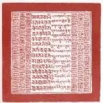
Great Seal of the Dalai Lama presented to him by the Tibetan National Assembly in 1909
Tibet was a fully functioning and independent state before the Chinese invasion. It threatened none of its neighbors, fed its population unfailingly, year after year, with no help from the outside world, and owed nothing to any country or international institution. Although insular, theocratic and not a modern democracy, Tibet maintained law and order within its borders and conscientiously observed treaties and conventions entered into with other nations. It was one of the earliest countries to enact laws to protect wildlife and the environment – recurrently cited in the “Mountain Valley Edicts” issued since 1642 [1], and possibly earlier. [2]
Tibet abolished capital punishment in 1913 (noted by many foreign travelers [3]) and was one of the first nations in the world to do so. There is no record of it persecuting minorities (e.g. Muslims [4]) or massacring sections of its population from time to time as China (remember Tiananmen) still does. Although Tibet ’s frontiers with India, Nepal and Bhutan were completely unguarded and Tibetans were “great travelers” [5], very few Tibetans fled their country as economic or political refugees. There was not a single Tibetan immigrant in the USA or Europe before the Communist invasion.
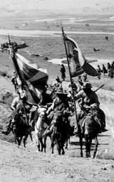
Tibetan soldiers with national flags
FOREIGN MILITARY INVASION NOT “PEACEFUL LIBERATION”
On the dawn of 5th October 1950, the 52nd, 53rd & 54th divisions of the 18th Army [6]of the Red Army (probably over 40,000 troops) attacked all along the cease-fire line ( mentsam-shagsa ) on the Drichu River guarded by 3,500 regular soldiers and 2,000 Khampa militiamen. Earlier, in late 1949, Communist forces had entered areas of Eastern (Kham) and North-Eastern Tibet (Amdo) then under the military occupation of Nationalist (Guomindang) supported war-lord regimes. Recent research by a Chinese scholar reveals that Mao Zedong met Stalin on 22nd January 1950 and asked for the Soviet air force to transport supplies for the invasion of Tibet. Stalin replied: “It’s good you are preparing to attack Tibet. The Tibetans need to be subdued.” [7]
An English radio operator Robert Ford (in Tibetan government service) at the Chamdo front wrote that Tibetan forward defenses at the main ferry point on the Drichu River fought almost to the last man. [8]In the south, at the river crossing near Markham, the frontline troops fought heroically but were wiped out, according to an English missionary eye-witness. [9]Surviving units conducted fighting retreats westwards. Four days into the retreat, one regiment was overwhelmed and destroyed. Two weeks after the initial attack, the Tibetan army finally surrendered. The biography of a Communist official states “Many Tibetans were killed and wounded in the Chamdo campaign.” and “… the Tibetan soldiers fought bravely, but they were no match for the superior numbers and better training” [10]of the Chinese forces. According to the only Western military expert who wrote on the Chinese invasion of Tibet “…the Reds suffered at least 10,000 casualties.” [11]One regiment of the Red army attacked from Xinjiang, but, in an account by a Chinese soldier [12], the advance guard was held back, to a near standstill, by the nomadic militia of Gertse in Ngari (Western Tibet). This soldier also writes that the Red Army leadership could find no Chinese maps of the region to plan their invasion, and eventually had to use one published in British-India. In 1956 the Great Khampa Uprising started and spread throughout the country culminating in the March Uprising of 1959. Guerilla operations only ceased in 1974. “A conservative estimate would have to be no less than half-a-million” [13]Tibetans killed in the fighting. Many more died in the subsequent political campaigns, forced labor camps ( laogai ) and the great famine. The revolutionary uprisings throughout Tibet from 1987 to 1990 and most recently in 2008 -followed by draconian Chinese reprisals – clearly demonstrate that the struggle continues today.
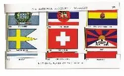
The modern Tibetan national flag was adopted in 1916. [14]Its international debut was in the National Geographic Magazine’s “Flags of the World” issue of 1934. [15]It even featured in a cigarette-card [16]series in Europe in 1933. The flag was probably too new to appear in the very first flag issue (1917) of the National Geographic , but Tibet does receive mention in an article on medieval flags in that same issue. [17]According to an eminent vexillologist, Professor Pierre Lux-Worm, the national flag of Tibet was based on an older 7th century snow lion standard of the Tibetan Emperor, Songtsen Gampo. [18]It should be borne in mind that over 90% of the flags of the nations in the UNO were created after WWII, including the national flag of China. The Tibetan flag made its official international appearance in 1947, at the First Inter-Asian Conference, which Mahatma Gandhi addressed. The Tibetan flag was displayed alongside other flags of Asian nations, and a circular flag emblem placed before the Tibetan delegation on the podium. [19]
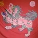
Ancient lion standard – courtesy of Tenzin.G.Tethong and AMI

First Inter-Asian Conference, Delhi, 1947.
The old Tibetan national anthem or national hymn, Gangri Rawae or “Snow Mountain Ramparts” [20]was composed in 1745 by the (secular) Tibetan ruler Pholanas. [21]It was recited at the end of official ceremonies and sung at the beginning of opera performances in Lhasa. [22]
When the Tibetan government came into exile in India, a more modern national anthem, Sishe Pende [23](“Universal Peace and Benefits”) was adopted. The lyrics were composed by the Dalai Lama’s tutor, Trichang Rimpoche, who was considered a great poet in the classical nyengak (Skt. kaviya ) tradition.
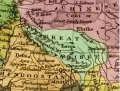
Detail from 1827 map [24]
Most pre-1950 maps, globes and atlases, including the earliest maps on record of Asia, depict Tibet as an independent nation, separate from China. Tibet is variously referred to as Tobbat, Thibbet or Barantola. A map of Asia drawn by the Dutch cartographer, Pietar van der Aa around 1680 shows Tibet in two parts but distinct from China; [25]as does a 1700 map drawn by the French cartographer Guillaume de L’isle, where Tibet is referred to as the “Kingdom of Grand Tibet.” [26]A map of India, China and Tibet published in the USA in 1877 represents Tibet as distinct from the two other nations. [27]An 1827 map of Asia drawn by Anthony Finley of Philadelphia, clearly shows “Great Thibet” as distinct from the Chinese Empire. [28]
Читать дальше


![Edzard Ernst - Trick or Treatment. The Undeniable Facts about Alternative Medicine [Electronic book text]](/books/151762/edzard-ernst-trick-or-treatment-the-undeniable-fa-thumb.webp)


