Jamyang Norbu - Independent Tibet – The Facts
Здесь есть возможность читать онлайн «Jamyang Norbu - Independent Tibet – The Facts» весь текст электронной книги совершенно бесплатно (целиком полную версию без сокращений). В некоторых случаях можно слушать аудио, скачать через торрент в формате fb2 и присутствует краткое содержание. Жанр: Современная проза, на английском языке. Описание произведения, (предисловие) а так же отзывы посетителей доступны на портале библиотеки ЛибКат.
- Название:Independent Tibet – The Facts
- Автор:
- Жанр:
- Год:неизвестен
- ISBN:нет данных
- Рейтинг книги:3 / 5. Голосов: 1
-
Избранное:Добавить в избранное
- Отзывы:
-
Ваша оценка:
Independent Tibet – The Facts: краткое содержание, описание и аннотация
Предлагаем к чтению аннотацию, описание, краткое содержание или предисловие (зависит от того, что написал сам автор книги «Independent Tibet – The Facts»). Если вы не нашли необходимую информацию о книге — напишите в комментариях, мы постараемся отыскать её.
Phayul[Friday, March 05, 2010 12:46]
This is a considerably revised and expanded version of the document, Losar Gift for Rangzen Activists, that I posted on Feb 25, 2009. This version has new information and illustrations. Last year when I was in India I gave a talk and powerpoint presentation based on this essay at a number of Tibetan schools and centers. I am happy to report that everyone was uplifted and energized by the sheer volume of indisputable facts substantiating Tibetan independence. It may have hit a sore spot in Beijing, though, for I was denounced at length on bbs.tibet.cn for this specific presentation. In order to ensure Beijing ’s continued “sensitivity” on the issue of Tibetan independence, a Chinese translation (in traditional as well as simplified script) will be up on lovetibet.ti-da.net, and other sites thanks to freedom activist Rosaceae. A full Tibetan translation will be at www.khabdha.org, and also be published in Tibet Times, all thanks to Gedun Rabsal la. You can also go on rangzen.net for the translations and for downloading print-ready pdf files to make flyers. I would like to thank all organizations that printed and distributed flyers last year, and would encourage them and others to do so again this year on March 10th and other occasions. Feel free to contact me for questions or suggestions.
Independent Tibet – The Facts — читать онлайн бесплатно полную книгу (весь текст) целиком
Ниже представлен текст книги, разбитый по страницам. Система сохранения места последней прочитанной страницы, позволяет с удобством читать онлайн бесплатно книгу «Independent Tibet – The Facts», без необходимости каждый раз заново искать на чём Вы остановились. Поставьте закладку, и сможете в любой момент перейти на страницу, на которой закончили чтение.
Интервал:
Закладка:
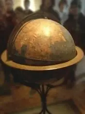
Martin Behaim’s globe at Nuremburg
The oldest existing globe in the world, and possibly the first terrestrial globe ever made, was constructed by Martin Behaim (geographer to the king of Portugal) in 1492. It depicts the world before the discovery of the Americas. Tibet is clearly identified in German as “Thebet ein konigreich”, or “ Tibet, a kingdom”. [29]
The largest stained glass globe in the world (in Boston), based on the Rand McNally 1934 map of the world, shows Tibet as a separate nation. [30]

The “Mapparium” in Boston, MA.
Early Chinese maps do not feature Tibet as a part of China. In a landmark map of China [31]drawn in 1594 by Wang Fen (or Wang Pan?), a senior Ming Legal Officer, there is a note stating that the map included the whole of China ’s territory. But no Tibetan areas, not even the eastern-most regions of Amdo or Kham, appear on the map.
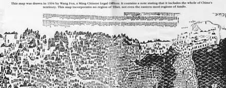
Upper section of 1594 Ming Map
Following the publication of the atlas commissioned by the Manchu Emperor Kangxi and created by French Jesuit cartographers, some Chinese and European maps begin to depict Tibet as a colony or protectorate of China. The Jesuits could not personally survey Tibet (as they had surveyed China and Manchuria), since Tibet was not part of the Chinese Empire. So they trained two Mongol monks [32]in Beijing and sent them to make a secret survey of Tibet. Similar clandestine surveys of Tibet were conducted by British mapmakers using trained Himalayan natives and even a Mongol monk. An American sinologist, writing on such issues, notes that, like European colonial powers, China used cartography to further its “Colonial Enterprise” in Tibet and Korea. [33]
TIBETAN CURRENCY
Literary sources [34]refer to gold, silver and copper ingot-coins, even cowrie shells, being used as currency in ancient Tibet. From circa 1650 silver coins for Tibet (the Bhal-tang) were struck in Nepal under a treaty agreement. [35]In 1792 following the defeat of Nepal by a joint Tibetan-Manchu force, coins bearing both Tibetan and Chinese inscriptions were circulated. But the Tibetan government continued to issue its own coin with only Tibetan legends as the Kongpar tangka (1791-93) and the Gaden tangka (1836-1911). A silver coin, the Kalsang tangka, was struck in 1909 possibly to mark the 13th Dalai Lama’s return to Lhasa from Peking.
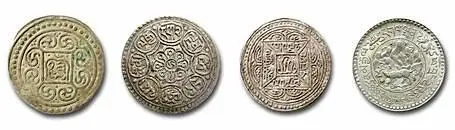
Kongpar tangka, Gaden tangka, Kalsang tangka and three Srang coin
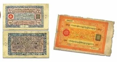
After the expulsion of the Chinese army in 1912, Tibet minted gold, silver and copper coins (in the “srang” currency unit) using Buddhist and Tibetan designs and bearing the name of the Tibetan government. Paper currency was introduced into Tibet in the early 20th century, and according to the numismatist Wolfgang Bertsch, these bank notes were “small works of art.” [36]A unique aspect of Tibetan banknotes was that the serial numbers were handwritten by a guild of specialist calligraphists, the “epa” , to prevent forgery.
Even after the Communist invasion, Tibetans successfully resisted Chinese efforts to take over its currency. Official Chinese currency only came into use after the flight of the Dalai Lama and the Tibetan government from Tibet in March 1959. [37]In its entire history, official Chinese currency had never been used in Tibet before 1959.
TIBETAN PASSPORTS
The Tibetan government issued its own passports to travelers entering its borders or (the few) Tibetans who traveled abroad. Before WWII, the term “passport” covered visas and travel documents in general. The earliest record of a Tibetan passport issued to a foreign traveler is in 1688 to an Armenian merchant, Hovannes (Johannes). [38]In 1780 a passport was issued from Lhasa [39]to Purangir Gossain, an emissary of the Governor-General of India, Warren Hastings, who hoped to open up Tibet to trade with the East India Company.
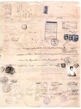
Passport issued to first Everest Expedition, 1921 (courtesy of Rinchen Dorjay).
The Tibetan government gave its approval for the first-ever Everest expedition in 1921. Charles Bell, the visiting British diplomat in Lhasa wrote “I received from the Tibetan Government a passport in official form, which granted permission for the climbing of Mount Everest.” [40]The subsequent Everest expeditions of 1924 and 1936 [41]also received passports from the Tibetan government. Passports were sometimes issued for scientific undertakings: the Schaeffer anthropological expedition of 1939, [42]Tucci’s ethnological expedition of 1949 [43]and the plant hunter Frank Kingdon Ward in 1924. [44]
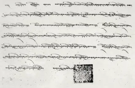
Shakabpa passport
President Roosevelt’s two envoys to Tibet in 1942 were presented their passports at Yatung. [45]The Americans Lowell Thomas Jr. and Sr. visited Tibet in 1949, and were issued “Tibetan passports” at Dromo. “When the Dalai Lama’s passport was spread out before us, I could not help thinking that many Western explorers who had failed to reach Lhasa would have highly prized a document like this.” [46]
Since 1912 passports were also issued to Tibetans leaving for foreign countries. [47]The first modern Tibetan passport [48]with personal information, photograph and space for visas and endorsements was issued in 1948 to members of the Tibetan trade mission. It was modeled on the international one-page fold-out model of 1915. Britain, the USA and seven other countries issued visas and transit visas for this document.
TREATIES
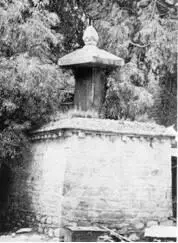
Treaty Pillar of 821-22 AD
One of the most important treaties between the Tibetan Empire and the Chinese Empire (concluded after a decisive Tibetan military victory) dates back to AD 821-822. The text, in Tibetan and Chinese was engraved on three stone pillars ( doring ). The only surviving pillar is near the Jokhang temple in Lhasa. [49]One clause affirms that between the two nations “…the very world ‘enemy’ shall not be spoken”.
Shol Doring
Another article regarding the frontier (near the present Gansu-Shaanxi border) makes clear that “All to the East is the country of Great China; and all to the West is, without question, the country of Great Tibet.” [50]
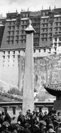
This treaty pillar is sometimes mistaken for the more eye-catching Shol doring before the Potala Palace, on which is inscribed the record of another great Tibetan victory, the capture of the Tang Imperial capital of Changan in 763 AD.
As an independent nation, Tibet entered into treaties with neighboring states: Bushair 1681, Ladakh 1683 and 1842, Nepal 1856 and so on.
Читать дальшеИнтервал:
Закладка:
Похожие книги на «Independent Tibet – The Facts»
Представляем Вашему вниманию похожие книги на «Independent Tibet – The Facts» списком для выбора. Мы отобрали схожую по названию и смыслу литературу в надежде предоставить читателям больше вариантов отыскать новые, интересные, ещё непрочитанные произведения.

![Edzard Ernst - Trick or Treatment. The Undeniable Facts about Alternative Medicine [Electronic book text]](/books/151762/edzard-ernst-trick-or-treatment-the-undeniable-fa-thumb.webp)


Обсуждение, отзывы о книге «Independent Tibet – The Facts» и просто собственные мнения читателей. Оставьте ваши комментарии, напишите, что Вы думаете о произведении, его смысле или главных героях. Укажите что конкретно понравилось, а что нет, и почему Вы так считаете.