Peter Friend - Southern England
Здесь есть возможность читать онлайн «Peter Friend - Southern England» — ознакомительный отрывок электронной книги совершенно бесплатно, а после прочтения отрывка купить полную версию. В некоторых случаях можно слушать аудио, скачать через торрент в формате fb2 и присутствует краткое содержание. Жанр: unrecognised, на английском языке. Описание произведения, (предисловие) а так же отзывы посетителей доступны на портале библиотеки ЛибКат.
- Название:Southern England
- Автор:
- Жанр:
- Год:неизвестен
- ISBN:нет данных
- Рейтинг книги:3 / 5. Голосов: 1
-
Избранное:Добавить в избранное
- Отзывы:
-
Ваша оценка:
Southern England: краткое содержание, описание и аннотация
Предлагаем к чтению аннотацию, описание, краткое содержание или предисловие (зависит от того, что написал сам автор книги «Southern England»). Если вы не нашли необходимую информацию о книге — напишите в комментариях, мы постараемся отыскать её.
Southern England — читать онлайн ознакомительный отрывок
Ниже представлен текст книги, разбитый по страницам. Система сохранения места последней прочитанной страницы, позволяет с удобством читать онлайн бесплатно книгу «Southern England», без необходимости каждый раз заново искать на чём Вы остановились. Поставьте закладку, и сможете в любой момент перейти на страницу, на которой закончили чтение.
Интервал:
Закладка:
Picture Credits
THE PHOTOGRAPHS and other illustrations that form such a key part of this book have come from many sources, and I am grateful to the following organisations and individuals for kindly allowing me to use their material:
Aerofilms (Figs 133, 232, 249, 252, 256, 258, 259, 261, 270, 280, 309, 312)
British Geological Survey (Figs 152, 284)
Cambridge News (Fig. 233)
Cambridge University Collection of Air Photographs (Figs 25, 118, 120, 243, 253, 282, 300, 310)
Cassini Publishing (Figs 26, 27)
Sylvia Cordaiy Photo Library (Fig. 141)
Robert Harding Picture Library (Fig. 313)
English Heritage (Figs 83, 308)
Landform Slides – Ken Gardner (Figs 17, 18, 43, 55, 70, 75, 76, 85, 88, 104, 161, 162, 165, 195)
Landform Slides – John L. Roberts (Fig. 69)
Last Refuge Ltd – Adrian Warren, Dae Sasitorn and Will Brett (Figs 41, 42, 46, 47, 53, 54, 56, 58, 60, 62, 63, 67, 68, 71, 72, 73, 74, 82, 86, 89, 90, 91, 101, 102, 103, 108, 110, 111, 112, 119, 121, 122, 125, 130, 132, 134, 135, 142, 144, 146, 148, 158, 163, 164, 169, 171, 175, 176, 185, 191, 192, 193, 194, 196, 216, 217, 218, 219, 220, 222, 254)
London Aerial Photo Library (Figs 23, 199, 205, 207, 235, 257, 277, 297, 298, 303, 314)
Norfolk Museums and Archaeology Service – Nick Arber (Fig. 16)
Norfolk Museums and Archaeology Service – Derek A. Edwards (Figs 1, 287, 293, 301, 302, 306, 307, 315)
Network Rail (Fig. 145)
Peter Oliver, Herefordshire and Worcestershire Heritage Trust (Fig. 172)
Mike Page (Fig. 311)
Science Photo Library (Fig. 2)
Sedgwick Museum, Cambridge (Fig. 239)
R. C. Selley – Petravin Press (Fig. 202)
Sheila Smart (Fig. 131)
Suffolk County Council (Fig. 255)
Victoria & Albert Museum (Fig. 250)
Illustrations that do not have a source credited in the caption are my own work, or that of the team working with me at the Department of Earth Sciences in Cambridge.
Author’s Foreword and Acknowledgements
MOST PEOPLE ENJOY SCENERY. In my case, an enthusiasm for exploring the countryside was learnt early on from my parents, and my career as a geologist has since allowed me to explore landscapes from the Arctic to tropical deserts and jungles. My hope is that this book will help more people to enjoy the countryside by bringing together some of the exciting recent discoveries about our Earth.
Landscapes are easy to look at, but difficult to describe in words. Recent developments in computer technology offer powerful ways of analysing and presenting landscapes using maps, diagrams and photographs, and it is this imagery that forms the core of this book. Developing the imagery has been the main role of a succession of enthusiastic helpers. Lucinda Edes, Emilie Galley, Liesbeth Renders and Helena Warrington brought their skills and enthusiasm to the early days of the project, working out what could be done best. James Sample has more recently further developed the methods of presentation, and has played a key role in bringing this project to fruition. All have helped to make the project enjoyable as well as productive.
The home for this project has been the Department of Earth Sciences at the University of Cambridge. I walked into the Department as a first-year undergraduate more than 50 years ago and, apart from a period in the Scott Polar Research Institute, I have been based here ever since. I have been teaching and exploring the scenery and geology of many parts of the world, including multiple visits to Spitsbergen, Greenland, Spain, India and Pakistan. This has been an exciting period to be working in geology, particularly in Cambridge, because many key advances have been achieved by the people working here. Apart from the great benefit of being part of this research environment, I have enjoyed the support of six successive Heads of Department and many other colleagues, especially our administrator Margaret Johnston and her team. It has been invaluable to have access to the excellent library run by Ruth Banger and Libby Tilley, and the patient computer support of Jun Aizawa, Aidan Foster, Pete Hill and Pete Wilkins.
I would also like to acknowledge my debt to the Cambridge college system, particularly my own college, Darwin. The College has provided me with the congenial friendship of many people from diverse backgrounds, and their skills have helped me to remain a generalist in my interests.
Any work of this sort on the British Isles owes a fundamental debt to the British Geological Survey (BGS), now based at Keyworth near Nottingham. The numerous Survey maps and reports on this country provide a remarkable source of carefully observed and objective information. The BGS has also readily provided advice and discussion of this project, and helped to determine the sort of coverage and level that would be best.
Many other people have made important contributions by providing ideas and information. These include: John R. L. Allen, Julian Andrews, Muriel Arber, Steve Boreham, Becky Briant, Keith Clayton, Tony Cox, Alan Dawn, Colin Forbes, Brian Funnell, Phillip Gibbard, Steve Jones, Gerald Lucy, Dan Mackenzie, Bob Markham, Charles Notcutt, Bernard O’Connor, Richard Preece, Graham Ward and Richard West.
This book is dedicated to the Dr John C. Taylor Foundation,which has provided the financial support for the project, allowing me to work with such a remarkable succession of talented young assistants. More than 40 years ago, John spent two summers exploring the geology of Spitsbergen with me, and we have remained friends ever since. I am extremely grateful for the help of his foundation during the writing of this book.
CHAPTER 1 Looking at Southern England’s Landscapes
FIRST APPROACHES
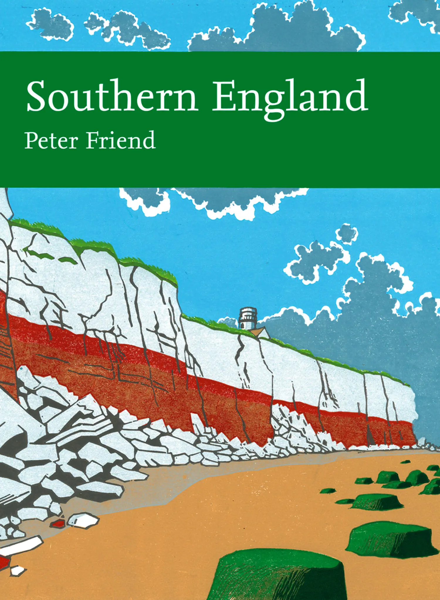
THE WORD LANDSCAPEhas different meanings for different people, and the best way to illustrate the meaning I have adopted in this book is to look at an example. I have chosen a landscape in the northwest corner of Norfolk, part of our East Anglia Region (Fig. 1).
FIG 1.Landscape of the northwest corner of Norfolk. (Copyright Norfolk Museums and Archaeology Service & Derek A. Edwards)
My approach is to focus first on the natural features that we can call landforms, because they have distinctive shapes that directly reflect the processes that formed them. In this Norfolk landscape, coastline landforms are clearly defined but are remarkably varied, ranging from sea cliffs to sandy beaches, gravel spits, wind-blown dunes and salt marshes. Inland, the main features in this photo are the groups of buildings that form the villages and the edge of the town of Hunstanton, and the pattern of fields and woods. All of these are man-made features and are best understood by following the work of landscape historians. My interest is primarily in the natural topography on which these man-made features have developed, because even in this rather flat landscape – and not clearly visible on the photograph – there are gentle hills, valleys and streams that I want to try to understand.
Читать дальшеИнтервал:
Закладка:
Похожие книги на «Southern England»
Представляем Вашему вниманию похожие книги на «Southern England» списком для выбора. Мы отобрали схожую по названию и смыслу литературу в надежде предоставить читателям больше вариантов отыскать новые, интересные, ещё непрочитанные произведения.


Обсуждение, отзывы о книге «Southern England» и просто собственные мнения читателей. Оставьте ваши комментарии, напишите, что Вы думаете о произведении, его смысле или главных героях. Укажите что конкретно понравилось, а что нет, и почему Вы так считаете.