Peter Friend - Southern England
Здесь есть возможность читать онлайн «Peter Friend - Southern England» — ознакомительный отрывок электронной книги совершенно бесплатно, а после прочтения отрывка купить полную версию. В некоторых случаях можно слушать аудио, скачать через торрент в формате fb2 и присутствует краткое содержание. Жанр: unrecognised, на английском языке. Описание произведения, (предисловие) а так же отзывы посетителей доступны на портале библиотеки ЛибКат.
- Название:Southern England
- Автор:
- Жанр:
- Год:неизвестен
- ISBN:нет данных
- Рейтинг книги:3 / 5. Голосов: 1
-
Избранное:Добавить в избранное
- Отзывы:
-
Ваша оценка:
Southern England: краткое содержание, описание и аннотация
Предлагаем к чтению аннотацию, описание, краткое содержание или предисловие (зависит от того, что написал сам автор книги «Southern England»). Если вы не нашли необходимую информацию о книге — напишите в комментариях, мы постараемся отыскать её.
Southern England — читать онлайн ознакомительный отрывок
Ниже представлен текст книги, разбитый по страницам. Система сохранения места последней прочитанной страницы, позволяет с удобством читать онлайн бесплатно книгу «Southern England», без необходимости каждый раз заново искать на чём Вы остановились. Поставьте закладку, и сможете в любой момент перейти на страницу, на которой закончили чтение.
Интервал:
Закладка:
FIG 51.Natural and man-made features of Area 1.
In the general section of this chapter it has been mentioned that the northern Scillies appear to have been invaded by ice late in the history of the last (Devensian) cold phase of the Ice Age (Fig. 49), and this is surprising in view of their southerly location. It appears that when the Devensian ice sheet had grown to its greatest extent, an elongate tongue of ice, perhaps some 150 km wide, extended for nearly 500 km from the Irish and Welsh ice sheets to the edge of the Atlantic continental shelf. This tongue became so large because it was vigorously fed by ice from the high ground of Ireland to the west, and the Lake District of England and the mountains of Wales to the east. The ice extended across the mouth of the Bristol Channel, well clear of the present north Cornwall coastline, before leaving ice-laid sediment on the northern fringe of the Isles of Scilly. South of the island areas that were covered by ice, the granite has been weathered locally into tors.
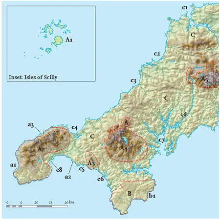
FIG 52.Area 1, showing Landscapes A to C and specific localities mentioned in the text. Major divisions of Landscape A are identified by A1, A2, A3etc., and localities are shown as a1, a2, a3etc.
Land’s End is the westernmost tip of mainland England. The local cliffs are made of granite and clearly show vertical sets of fractures, probably formed when the granite was cooling and contracting (Figs 54 and 55). Apart from the fractures, the granite is massive compared with the strongly layered and deformed rocks into which the main granites were intruded. Most of the northerly inland areas are exposed and windswept moorland, though arable farming for early vegetables has developed in the valleys to the south. The valleys eroded in the Land’s End granite are distinct and often oriented very clearly in a northwest-southeast direction. This orientation is parallel to a large number of faults which appear to have first formed late in the Variscan mountain-building episode. However, they must also have been active much later, after the intrusion of the main granite, because its margin is locally offset by faults with this trend. The movement of superheated water along these fault systems has resulted in mineralisation of the bedrock, altering its resistance to erosion so that valley incision has taken place preferentially in this direction. Tors are largely absent from the Land’s End, Godolphin, Carnmenellis and St Austell granite areas, while they are common weathering features on Bodmin Moor and Dartmoor. This probably reflects a difference in the weathering and uplift histories of the different granite bodies.

FIG 53.The Isles of Scilly, looking east towards Bryher, Tresco and St Martins. (Copyright Dae Sasitorn & Adrian Warren/www.lastrefuge.co.uk)
The Land’s End granite ( A2) forms the bedrock of most of the far southwestern peninsula, which is largely ringed by cliffs. To the east of the granite, St Ives Bay on the north coast and Mount’s Bay on the south coast show how much more readily eroded the Devonian killas is in comparison. Along the north coast of the Land’s End peninsula, the killas is preserved as a screen of land, rarely more than a kilometre in width, but clearly showing distinctive layering, as seen at Gurnard’s Head ( a3; Fig. 56). Present coastal erosion may have been slowed at this point by the greater strength of the Devonian where it has been altered close to the granite. Just north of Land’s End point, Whitesands Bay ( a1) is one of the only sandy bays to face the open sea to the west. The bay lacks any significant stream system that could have supplied sand to the beach, so it seems most likely that the sand has been carried into this bay by the storms which so often attack this exposed coast.
FIG 54.Land’s End peninsula from the air, looking eastwards. Note the lack of clear layering in the granite bedrock and the steep fracture surfaces (joints) that have controlled the form of the cliffs. (Copyright Dae Sasitorn & Adrian Warren / www.lastrefuge.co.uk)
A distinct, though irregular, platform at 100–150 m above sea level rings the area of the Land’s End granite, and tends to be followed by local roads. This may have been formed during an early episode of coastal erosion, when sea level was standing at this height relative to the land (Fig. 57). Some evidence for its age is mentioned below. Its irregularity probably reflects local valley erosion that has taken place since its formation.
FIG 55.Land’s End cliffs, looking westwards. Again, note the vertical jointing. (Copyright Landform Slides – Ken Gardner)
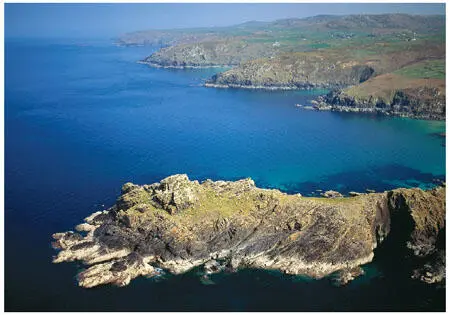
FIG 56.Gurnard’s Head (Fig. 52, a3), west of St Ives, showing the coastline along the northern edge of the Land’s End granite. (Copyright Dae Sasitorn & Adrian Warren/www.lastrefuge.co.uk)
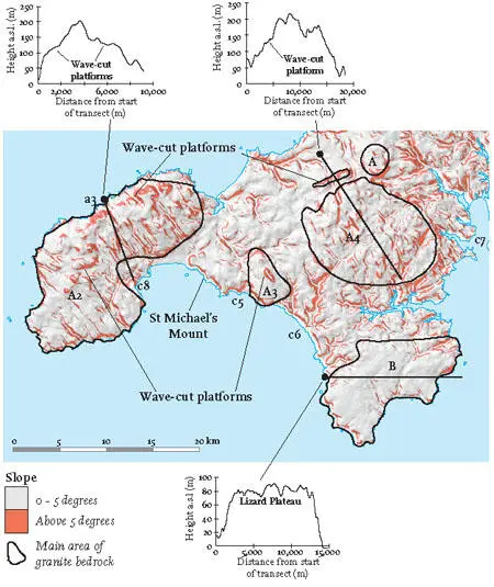
FIG 57.Slope map showing the southwestern part of Area 1. Slopes greater than 5 degrees are coloured red, and the main granite areas and the Lizard Complex are outlined. Topographic cross-sections illustrate wave-cut platforms that are presently inland and show the lack of topography on the Lizard Plateau.
The next main granite bedrock area to the east underlies the Carnmenellis area ( A4), although there are other smaller granite areas, such as St Michael’s Mount (Fig. 58), across the bay from Penzance, and the intermediate-sized Godolphin granite ( A3), some 8 km to the east. These smaller granite areas show the range in size of ‘feeders’ that branched off from the major granite body that underlies the whole Southwest Region (Fig. 44). In all cases the granite bedrock corresponds to high ground in the landscape – evidence of the greater resistance of the granite in the face of repeated landscape erosion. Derelict mine engine houses litter the landscape, especially northwards near Camborne and Redruth, once prosperous tin-mining centres. To the south, the landscape is more sheltered and fertile, allowing better farming. Trees are rare because of their past cutting for fuel for the mining industry, as well as because of the general exposure of the landscape to the weather.
FIG 58.St Michael’s Mount. (Copyright Dae Sasitorn & Adrian Warren/ www.lastrefuge.co.uk)
The same northwest-to-southeast valley pattern that has just been mentioned in the Land’s End granite is also apparent in the area around the Carnmenellis granite, and appears to be the result of preferential stream erosion parallel to the faults trending in this direction (Fig. 59).
FIG 59.Sketch map showing the orientation of some of the main faults in West Cornwall.
Another similarity to Land’s End is the widespread topographic platform at about 140 m above sea level. This platform is particularly clear north of the Carnmenellis granite but is also obvious in the Godolphin granite (Fig. 57). In the Porthmeor and Camborne areas the platform is particularly distinctive, and the continuity of its landward slope is clear on the slope map. It has generally been assumed that these platforms were cut by storm waves when the sea stood at this level about 3 million years ago. At this time, West Cornwall would have consisted of granite islands, like the present Isles of Scilly, while the surrounding Devonian bedrock (killas) was submerged.
Читать дальшеИнтервал:
Закладка:
Похожие книги на «Southern England»
Представляем Вашему вниманию похожие книги на «Southern England» списком для выбора. Мы отобрали схожую по названию и смыслу литературу в надежде предоставить читателям больше вариантов отыскать новые, интересные, ещё непрочитанные произведения.


Обсуждение, отзывы о книге «Southern England» и просто собственные мнения читателей. Оставьте ваши комментарии, напишите, что Вы думаете о произведении, его смысле или главных героях. Укажите что конкретно понравилось, а что нет, и почему Вы так считаете.