Peter Friend - Scotland
Здесь есть возможность читать онлайн «Peter Friend - Scotland» — ознакомительный отрывок электронной книги совершенно бесплатно, а после прочтения отрывка купить полную версию. В некоторых случаях можно слушать аудио, скачать через торрент в формате fb2 и присутствует краткое содержание. Жанр: unrecognised, на английском языке. Описание произведения, (предисловие) а так же отзывы посетителей доступны на портале библиотеки ЛибКат.
- Название:Scotland
- Автор:
- Жанр:
- Год:неизвестен
- ISBN:нет данных
- Рейтинг книги:3 / 5. Голосов: 1
-
Избранное:Добавить в избранное
- Отзывы:
-
Ваша оценка:
Scotland: краткое содержание, описание и аннотация
Предлагаем к чтению аннотацию, описание, краткое содержание или предисловие (зависит от того, что написал сам автор книги «Scotland»). Если вы не нашли необходимую информацию о книге — напишите в комментариях, мы постараемся отыскать её.
Scotland — читать онлайн ознакомительный отрывок
Ниже представлен текст книги, разбитый по страницам. Система сохранения места последней прочитанной страницы, позволяет с удобством читать онлайн бесплатно книгу «Scotland», без необходимости каждый раз заново искать на чём Вы остановились. Поставьте закладку, и сможете в любой момент перейти на страницу, на которой закончили чтение.
Интервал:
Закладка:
VERTICAL CRUSTAL MOVEMENTS
The movement of lithospheric plates, as described above, is the main cause of horizontal convergent and divergent movements affecting thousands of kilometres of the Earth’s surface. As shown in Figures 16to 18, horizontal movements are generally accompanied by vertical movements of local crustal surfaces. Some of these could have produced very large scenic features, such as a mountain belt or a rift valley. In this book we are primarily concerned with scenic features at a more local scale, so we now consider various other processes that may contribute to the creation of vertical crustal movements.
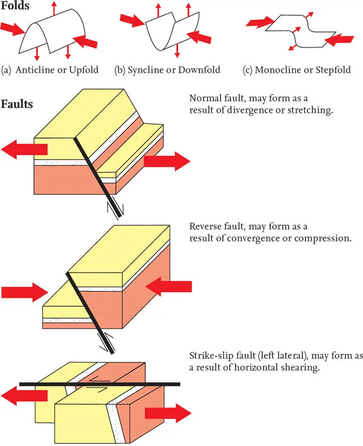
FIG 17. The most important types of folds and faults, and the local patterns of forces responsible.
Vertical crustal movement linked to erosion or deposition
Addition or subtraction of material to the surface of the Earth is happening all the time as sediment is deposited or solid material is eroded. The discipline of sedimentology is concerned with the wide range of different processes that are involved in the erosion, transport and deposition of material, whether the primary agent of movement is water, ice, mud or wind. An important point is that few of these sedimentary processes relate directly to the large tectonic movements of the Earth’s crust that we have discussed above. Landscape is often produced by erosion of thick sedimentary deposits that formed in sedimentary basins where material eroded from the surrounding uplands accumulated. One of the characteristic features of these thick deposits is their layered appearance – as, for example, in the Torridonian Sandstones of northwestern Scotland (see Chapter 4). Layering varies from millimetre-scale laminations produced by very small fluctuations in depositional processes, to sheets hundreds of metres thick that extend across an entire sedimentary basin. These thicker sheets are often so distinctive that they are named and mapped as separate geological units representing significant changes in the local environment at the time they were deposited.
FIG 18. Example of a cross-section through the crust, showing how a divergent movement pattern (A) may be modified by later convergent movements (B and C).
Vertical crustal movements due to loading or unloading
In addition to the direct raising or lowering of the surface by erosion or deposition, there is a secondary effect due to the unloading or loading of the crust that may take some thousands of years to produce significant effects. As mentioned above, we can visualise the lithosphere as ‘floating’ on the asthenosphere like a boat floating in water. Loading or unloading the surface of the Earth by deposition or erosion will therefore lower or raise the scenery, just as a boat will sit lower or higher in the water depending on its load.
An example of such loading has been the build-up of ice sheets during the Ice Age. The weight of these build-ups depressed the Earth’s surface in the areas involved, and when the ice melted the Earth’s surface rose again. Western Scotland provides an example of an area that has been rising because of ‘rebound’ since the ice of the Ice Age disappeared on melting.
A second example of this is the lowering of the area around the Mississippi Delta, loaded by sediment eroded from the more central and northern parts of North America. The Delta region, including New Orleans, is doomed to sink continually as the Mississippi River deposits sediment around its mouth, increasing the crustal load there.
Conversely, unloading of the Earth’s surface will cause it to rise. Recent theoretical work on the River Severn suggests that unloading of the crust by erosion may have played a role in raising the Cotswold Hills to the east and an equivalent range of hills in the Welsh Borders.
Vertical movements due to thermal expansion or contraction
Changes in the temperature of the crust and lithosphere are an inevitable result of many of the processes active within the Earth, because they often involve the transfer of heat. In particular, rising plumes of hot material in the Earth’s mantle, often independent of the plate boundaries, are now widely recognised as an explanation for various areas of intense volcanic activity (for example beneath Iceland today). These plumes are often referred to as ‘hot spots’ ( Fig. 15). Heating and cooling leads to expansion or contraction of the lithosphere and can cause the surface to rise or sink, at least locally.
An example of this is the way that Britain was tilted downwards to the east about 60 million years ago. At about this time, eastern North America moved away from western Europe as the North American and Eurasian plates diverged. The divergence resulted in large volumes of hot material from deep within the Earth being brought to the surface and added to the crust of western Britain. It is believed that the heating and expansion of the crustal rocks in the west has elevated them above the rocks to the east, giving an eastward tilt to the rock layers and exposing the oldest rocks in the west and the youngest ones in the east.
THE CHALLENGE OF MEASURING CRUSTAL MOVEMENTS
Having just reviewed some of the processes that may cause movements of the Earth’s surface, it is useful to consider the practical difficulties of how such movements are measured.
For present-day applications, it seems natural to regard sea level as a datum against which vertical landscape movements can be measured, as long as we remember to allow for tidal and storm variations. However, much work has demonstrated that global sea level has changed rapidly and frequently through time, due to climate fluctuations affecting the size of the polar icecaps and changing the total amount of liquid water present in the oceans and seas (see Chapter 5). It has also been shown that plate tectonic movements can have an important effect on global sea level by changing the size and shape of ocean basins.
Attempts have been made to develop charts showing how sea level, generalised for the whole world, has varied through time. However, it has proved very difficult to distinguish a worldwide signal from local variations, and the dating of the changes is often too uncertain to allow confident correlation between areas.
In sedimentary basins, estimates of vertical movements have been made using the thicknesses of sediment layers accumulating over different time intervals in different depths of water. In areas of mountain building, amounts of vertical uplift have been estimated using certain indicator minerals that show the rates of cooling that rocks have experienced as they were brought up to the surface. However, both these approaches are only really possible in areas that have been subjected to movements of the Earth’s crust that are large and continuous enough to dominate completely other possible sources of error.
Local movements are also difficult to estimate, although fold and/or fault patterns may allow a simple measure in some cases. Over short present-day periods of time it has proved to be possible to detect vertical movement patterns using satellite imagery. Movement of sediment across the Earth’s surface by rivers or sea currents can be estimated if mineral grains in the sediment can be tracked back to the areas from which they have come. In the detailed consideration of landscapes in this book, we have to rely on using the widest possible range of types of evidence, carefully distinguishing the times and scales involved. Even then, we are often left with probable movement suggestions rather than certainties.
CHAPTER 4
Episodes in the Bedrock History of Scotland
Читать дальшеИнтервал:
Закладка:
Похожие книги на «Scotland»
Представляем Вашему вниманию похожие книги на «Scotland» списком для выбора. Мы отобрали схожую по названию и смыслу литературу в надежде предоставить читателям больше вариантов отыскать новые, интересные, ещё непрочитанные произведения.


Обсуждение, отзывы о книге «Scotland» и просто собственные мнения читателей. Оставьте ваши комментарии, напишите, что Вы думаете о произведении, его смысле или главных героях. Укажите что конкретно понравилось, а что нет, и почему Вы так считаете.