Peter Friend - Scotland
Здесь есть возможность читать онлайн «Peter Friend - Scotland» — ознакомительный отрывок электронной книги совершенно бесплатно, а после прочтения отрывка купить полную версию. В некоторых случаях можно слушать аудио, скачать через торрент в формате fb2 и присутствует краткое содержание. Жанр: unrecognised, на английском языке. Описание произведения, (предисловие) а так же отзывы посетителей доступны на портале библиотеки ЛибКат.
- Название:Scotland
- Автор:
- Жанр:
- Год:неизвестен
- ISBN:нет данных
- Рейтинг книги:3 / 5. Голосов: 1
-
Избранное:Добавить в избранное
- Отзывы:
-
Ваша оценка:
Scotland: краткое содержание, описание и аннотация
Предлагаем к чтению аннотацию, описание, краткое содержание или предисловие (зависит от того, что написал сам автор книги «Scotland»). Если вы не нашли необходимую информацию о книге — напишите в комментариях, мы постараемся отыскать её.
Scotland — читать онлайн ознакомительный отрывок
Ниже представлен текст книги, разбитый по страницам. Система сохранения места последней прочитанной страницы, позволяет с удобством читать онлайн бесплатно книгу «Scotland», без необходимости каждый раз заново искать на чём Вы остановились. Поставьте закладку, и сможете в любой момент перейти на страницу, на которой закончили чтение.
Интервал:
Закладка:
FIG 6. Models of downslope movement: (a) uniform material and movement; (b) non-uniform material and non-uniform movement (greatest from upper slope).
We can demonstrate the widespread importance of these river-generated landforms by plotting the pattern of large river catchments across present-day Scotland ( Fig. 7). This map further supports the claim that these river and stream agents are easily the most important agents in the modification by erosion of Scotland and its landscapes. This map has been compiled using data from the Scottish National River Flow Archive collected by the Environment Protection Agency. The areas of the larger river catchments are superimposed on an elevation-shaded map of most of Scotland. In the interests of clarity, only the larger catchments are shown, leaving clear a zone of land, up to some 40 km wide, around the coast and including the islands, where the catchments are smaller.
FIG 7. The larger river catchments of Scotland, based on the Scottish National River Flow Archive.
One great contrast between western and eastern Scotland is shown very clearly by the rainfall data averaged over the year and over the catchments, varying from more than 2000 mm to less than 1000 mm per year. The other variable plotted in Figure 7is river flow rate (in m3/s), averaged over the year from the daily flow rates measured at the river gauge furthest downstream on each principal river. These flow rates give a first feel for the normal size of the river, but, of course, much of the work of rivers in eroding and transporting material is carried out during major floods, so our data give only limited grounds for comparison. Even with these data, it is interesting to see that the Tay (167.9 m3/s) is easily the largest river under most conditions, reflecting its large catchment area and its mid-range rainfall. It is interesting to note that the Thames and the Severn, in England and Wales, which both have large estuaries, have flow rates upstream from the tidal estuaries that are distinctly smaller (66 m3/s and 106 m3/s, respectively).
Some consideration can be given in our Area treatments to the shape and location of the different catchments, and to the bedrock materials and movements that may have been involved. Here the important general point that emerges is that the surface modification processes occurring in these river and valley catchments in Scotland bear a unique responsibility for the changes taking place now in the landscapes that we want to understand better.
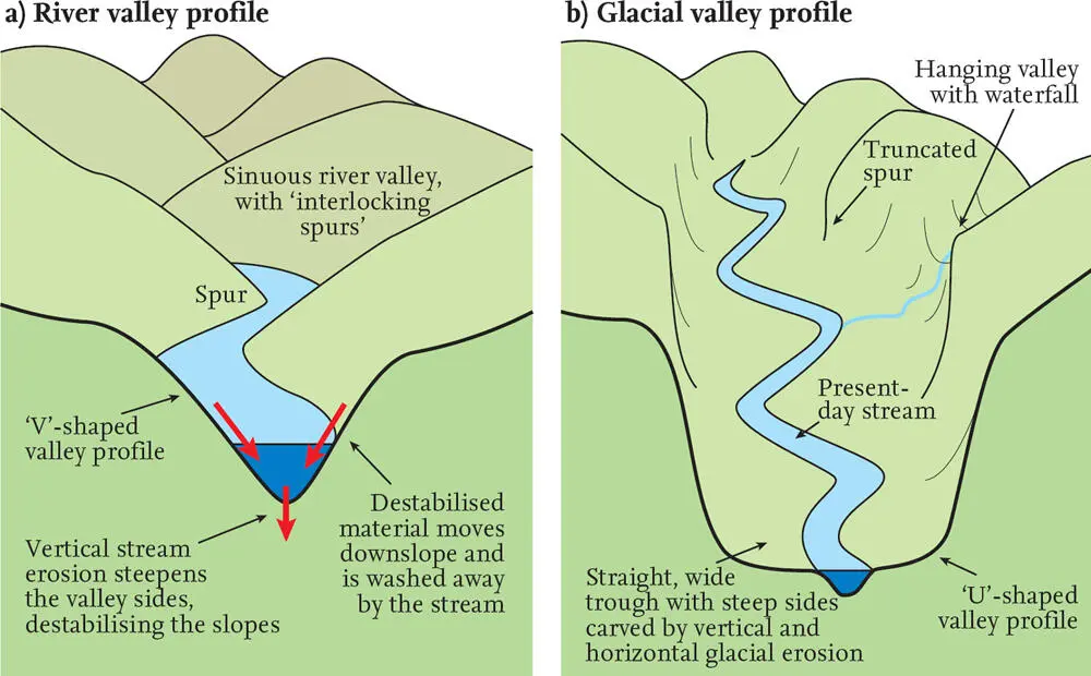
FIG 8. Comparison of valley cross-sections: (a) a simple valley created by channel incision in balance with the valley slope evolution; (b) a valley created by glacial incision and now occupied by a stream channel of similar water discharge to the earlier glacier, but now incising a much smaller channel.
Valleys are bounded by boundary slopes that are inclined downwards towards the stream or river that flows along them. They can therefore be picked out on slope maps as pairs of areas of sloping pixels, providing clear evidence of the action of valley erosion, and the role of channel processes in the erosion of the catchment. Whereas downslope mass movement is a key component in removing material from the catchment, the incision and lowering of the river channel must also exert a control on the extent to which slope materials can be removed and transported down-channel and out of the catchment.
V-shaped cross-valley profiles in upland areas are commonly interpreted as the result of river or stream erosion by the valley channel. In contrast, U-shaped profiles are frequently interpreted as the products of glacial erosion ( Fig. 8). It is generally accepted that most upland river valleys have a V-shaped profile, whereas upland valleys that have been occupied by glaciers tend to have U-shaped profiles. This can be readily understood in terms of the small eroding perimeter of a water-filled channel compared with the larger eroding perimeter of the much larger glacier channel, even though the discharge (in m3/s) of rapidly flowing water or slowly moving ice down the valleys may have been similar under the two climatic regimes.
Another climate-related factor should be mentioned at this point. Under periglacial (near-glacial) conditions, freeze–thaw processes, particularly within the surface blanket, will often keep the blanket materials in a state of frequent downslope movement. The degree to which this happens is likely to have a profound influence on the evolution of valley-slope and channel systems.
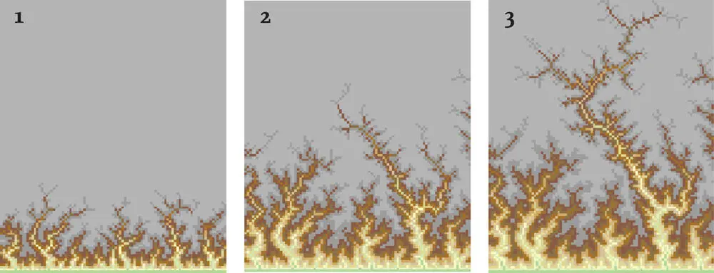
FIG 9. Dendritic channel pattern growth. This shows three phases in the development of a computer-based erosional model, in which valley erosion from the southern edge of a study area proceeds by headward erosion of each valley which is randomly free to choose its erosion direction. The map model was provided by Dimitri Lague and was based on the work of A. Crave and P. Davy.
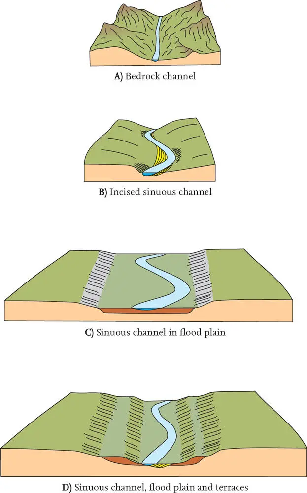
FIG 10. Other landforms typical of river catchments, including channels of different geometries, flood plains and river terraces.
The catchment map ( Fig. 7) shows clearly the dendritic patterns developed by all river and stream drainage systems, and it is these patterns ( Fig. 9) that make the recognition of valleys so easy on our slope maps.
In the lower reaches of channel systems, other landforms develop that are typical of deposition of sediment being carried down the system ( Fig. 10). This may influence the sinuosity of the channels, so that only slightly sinuous channels, often carrying rather coarse gravel or sandy sediment, may be replaced downstream by meandering (highly sinuous) channels that flow between banks of muddy sediment. Flood plains of relatively fine-grained sediment are increasingly the obvious landforms low down in river systems, and these are typically very flat extensive plains. Terraces often represent fragments of former flood plains left at a higher level as the active channel has cut down to a lower elevation.
SEA COASTS
A special slope consideration is raised by the landscapes of Figure 1, and frequently in other parts of Scotland also. This occurs where a change of sea level has initiated the formation of new coastal landforms, sometimes largely erosional and sometimes depositional ( Fig. 11).
Erosion of a coastal slope has similarities to the erosion of river or stream valley slopes, except that coastal slopes are caused by mass downslope movement towards sites of sea-cliff erosion. A very different situation occurs where sea-level changes initiate the deposition of sediment to form coastal flats, with very flat overall slopes, and patterns of coastal sediment bars, sediment flats and salt-marshes. Sediment supply is obviously a key factor in the growth of potentially extensive landforms and landscapes, often with distinctive landforms and very flat surfaces or zero-angle overall slopes.
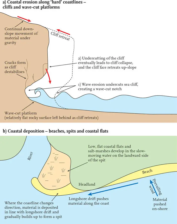
FIG 11. Coastal slopes: erosion and deposition; a) ‘vertical profile’ and b) ‘plan view’.
CHAPTER 3
Movements of the Earth from Within
EARTH-SURFACE MOVEMENTS DUE TO PLATE TECTONICS
TO UNDERSTAND THE CHANGES AND MOVEMENTS affecting the appearance of the landscape on large scales we need to review current understanding of some geological systems, especially plate tectonics. Many of the widespread changes that have created landscapes over long periods of time can now be understood using this discovery.
Читать дальшеИнтервал:
Закладка:
Похожие книги на «Scotland»
Представляем Вашему вниманию похожие книги на «Scotland» списком для выбора. Мы отобрали схожую по названию и смыслу литературу в надежде предоставить читателям больше вариантов отыскать новые, интересные, ещё непрочитанные произведения.


Обсуждение, отзывы о книге «Scotland» и просто собственные мнения читателей. Оставьте ваши комментарии, напишите, что Вы думаете о произведении, его смысле или главных героях. Укажите что конкретно понравилось, а что нет, и почему Вы так считаете.