Rosemary Parslow - The Isles of Scilly
Здесь есть возможность читать онлайн «Rosemary Parslow - The Isles of Scilly» — ознакомительный отрывок электронной книги совершенно бесплатно, а после прочтения отрывка купить полную версию. В некоторых случаях можно слушать аудио, скачать через торрент в формате fb2 и присутствует краткое содержание. Жанр: unrecognised, на английском языке. Описание произведения, (предисловие) а так же отзывы посетителей доступны на портале библиотеки ЛибКат.
- Название:The Isles of Scilly
- Автор:
- Жанр:
- Год:неизвестен
- ISBN:нет данных
- Рейтинг книги:3 / 5. Голосов: 1
-
Избранное:Добавить в избранное
- Отзывы:
-
Ваша оценка:
The Isles of Scilly: краткое содержание, описание и аннотация
Предлагаем к чтению аннотацию, описание, краткое содержание или предисловие (зависит от того, что написал сам автор книги «The Isles of Scilly»). Если вы не нашли необходимую информацию о книге — напишите в комментариях, мы постараемся отыскать её.
The Isles of Scilly — читать онлайн ознакомительный отрывок
Ниже представлен текст книги, разбитый по страницам. Система сохранения места последней прочитанной страницы, позволяет с удобством читать онлайн бесплатно книгу «The Isles of Scilly», без необходимости каждый раз заново искать на чём Вы остановились. Поставьте закладку, и сможете в любой момент перейти на страницу, на которой закончили чтение.
Интервал:
Закладка:
The whole southern part of the island delights in the charming name of Wingletang Down, an extensive stretch of maritime heath with the twin bays of Wingletang Bay on the east and Porth Askin on the west, with the rocky promontory of Horse Point at the southern tip of the island where the land falls into the sea among short maritime grassland and a great chaos of tumbled rocks. Horse Point is almost separated from the rest of the island by the two bays and a narrow sandy neck of land, and it seems highly probable that one day it will eventually be cut through. In the middle of Wingletang Bay is Beady Pool, so named because it is where the small barrel-shaped brown beads from a seventeenth-century wreck have been found. At the back of the bay yellow horned-poppy, sea-kale and sea spurge surmount the low dune bank. Shore dock once appeared in a sand pit here (illicit digging possibly having exposed buried seed), but died out after a few years to reappear in a dune blow-out on the opposite side of the island beside Porth Askin; unfortunately it soon died out there as well. Wingletang Down is very important botanically: rarities such as orange bird’s-foot and small adder’s-tongue fern grow here, but it is also the only locality in Scilly for the very rare least adder’s-tongue fern, known in Britain only from here and the Channel Islands.
St Warna’s Cove is a rocky, south-facing bay on the west of St Agnes. This section of the coast is studded by a number of huge carns that continue right around the west side of the island (Fig. 52). The cove is overlooked by a curiously shaped rock called Nag’s Head on the heathland below the distinctive outline of the coastguard cottages (Fig. 53). And close to the shore is a stone-lined well that is possibly of great antiquity – it is reputed to be close to where the saint is supposed to have landed from Ireland in his coracle. Traditionally pins should be dropped in the well to encourage storms to drive a wreck ashore! Castella
FIG 52.Granite carns at St Warna’s Cove, St Agnes, August 2003. (Rosemary Parslow)
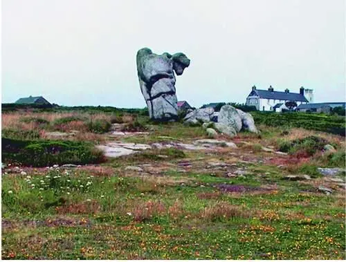
FIG 53.The Nag’s Head and the coastguard cottages, St Agnes, July 2002. (Rosemary Parslow)
Downs, an area of rabbit-grazed coastal grassland and rough heathland further to the west, is where the Troy Town maze, actually a pebble labyrinth, is set in the turf
Gugh
The island of Gugh might be described as the sixth inhabited island, but it is usually included with St Agnes. At low tide you can cross the Bar – a sand bar, strictly a tombolo – from one island to the other. Immediately at the end of the Bar is a small area of dune and dune grassland merging into the maritime grassland fringe around the island. A dense edge of sea-holly Eryngium maritimum marks the dune edge and both sea and Portland spurge are found here with sea bindweed and other coastal plants. The grass bank at the top of the Bar is one of the few places where wild thyme grows; earlier in the year western clover and early meadow-grass are also abundant here. This is another beach where the lesser cockroach has been found. The majority of the island is wind-pruned waved heath or dense gorse and bracken, with maritime grassland around the coastal fringe and on the north and southwest of the island. The summit of Gugh
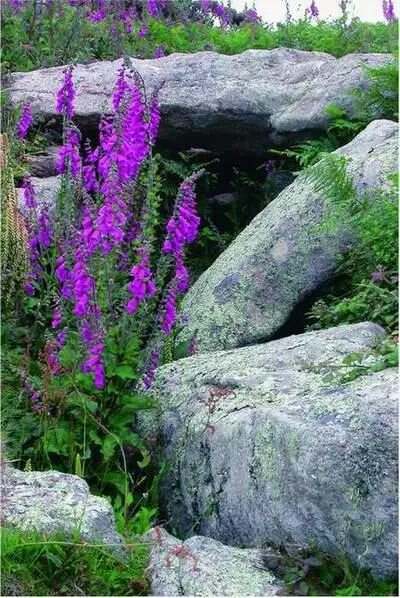
FIG 54.Named after islander Obadiah Hicks is Obadiah’s Barrow, an entrance grave on Gugh, half hidden among foxgloves and wall pennywort. June 2003. (Rosemary Parslow)
is remarkable for the number of archaeological remains that are still visible: on top of the hills that form the spine of the island are a series of Bronze Age barrows, remnants of walls and a standing stone known as the Old Man of Gugh. Another well-known barrow, Obadiah’s Barrow, lies among dense gorse on the side of the hill (Fig. 54). For a small island there is an extensive list of rare and unusual plants, lichens and invertebrates.
The former Gugh farm occupies the central area just north of the neck across the middle of the island, between the two heathy hills that make up the body of the island. Two houses now stand there; they were built by a Mr Cooper in about 1920 and they have strange curved concrete roofs, like upturned boats, designed to withstand gales (Fig. 55). When Cooper died he was buried on the island. On the east coast of Gugh is a bay with dazzling white sand called Dropnose Porth. This curious name occurs elsewhere in Scilly, so maybe this is a humorous, descriptive reference to a nearby rock. Many of the granite carns and rocks have been eroded into fantastic shapes. There is a rock near Kittern Hill at the north end of Gugh that, seen from the sea, appears to have been sculpted into a likeness of Queen Victoria – though from a slightly different angle it becomes a Red Indian brave!
The sandy neck between the two hills formed from blown sand has an unusual flora. Growing among the bracken beside the path are dog roses Rosa
FIG 55.The tide just covering the Bar (strictly a tombolo) from St Agnes to Gugh, November 2002. (Rosemary Parslow)
canina and an unidentified yellow rose (presumed an escape from cultivation). Balm-leaved figwort is very common here, despite not being found elsewhere on the island. Another plant found in this vicinity is the alien Argentine dock Rumex frutescens . This grows on the edge of the abandoned sand pit, originally dug as a reservoir. In the field below the Gugh houses from about 1933 viper’s-bugloss Echium vulgare , wild mignonette Reseda lutea and common melilot Melilotus officinalis were found, although not all have been seen recently. Their presence in the field has been attributed to the use of shoddy (a high-nitrate manure deriving from the wool industry) before 1933. In the 1960s this neck area was close-cropped grassy sward, a good place to find mushrooms, where thousands of garden tiger Arctia caja caterpillars would swarm and cuckoos Cuculus canorus would arrive to feed on them, and where wheatears would also appear on passage (J. Parslow, in litt .). When myxomatosis reduced the rabbit population, the neck became overgrown with brambles and bracken, and the open turf and the grass tennis court that was there all disappeared from view (W. Hick, personal communication).
Along the top of Gugh, just above Obadiah’s Barrow, there was a heath fire in October 1972 that burned down through the shallow peat soil to the granite. As a result recovery has been slow and even now traces of the fire can still be seen, in blackened stems of gorse and bleached rocks. There have also been changes in the vegetation: yellow bartsia Parentucellia viscosa , for example, became very common in the burnt area and for a time English stonecrop and bird’s-foot-trefoil were dominant plants on the bare ground. Elsewhere heathland extends along the crest of the island, both north and south of the ‘neck’. Sometimes the rare orange bird’s-foot can be found on one of the larger carns in the southern half of the island. Here too are extensive colonies of lesser black-backed gulls Larus fuscus , herring gulls L. argentatus and a few great black-backed gulls L. marinus . It is wise to avoid the gull colonies during the breeding season, as the gulls are likely to ‘dive-bomb’ people who approach too close to their nests, and can be very intimidating.
Читать дальшеИнтервал:
Закладка:
Похожие книги на «The Isles of Scilly»
Представляем Вашему вниманию похожие книги на «The Isles of Scilly» списком для выбора. Мы отобрали схожую по названию и смыслу литературу в надежде предоставить читателям больше вариантов отыскать новые, интересные, ещё непрочитанные произведения.


Обсуждение, отзывы о книге «The Isles of Scilly» и просто собственные мнения читателей. Оставьте ваши комментарии, напишите, что Вы думаете о произведении, его смысле или главных героях. Укажите что конкретно понравилось, а что нет, и почему Вы так считаете.