Sustainable Development Practices Using Geoinformatics
Здесь есть возможность читать онлайн «Sustainable Development Practices Using Geoinformatics» — ознакомительный отрывок электронной книги совершенно бесплатно, а после прочтения отрывка купить полную версию. В некоторых случаях можно слушать аудио, скачать через торрент в формате fb2 и присутствует краткое содержание. Жанр: unrecognised, на английском языке. Описание произведения, (предисловие) а так же отзывы посетителей доступны на портале библиотеки ЛибКат.
- Название:Sustainable Development Practices Using Geoinformatics
- Автор:
- Жанр:
- Год:неизвестен
- ISBN:нет данных
- Рейтинг книги:4 / 5. Голосов: 1
-
Избранное:Добавить в избранное
- Отзывы:
-
Ваша оценка:
Sustainable Development Practices Using Geoinformatics: краткое содержание, описание и аннотация
Предлагаем к чтению аннотацию, описание, краткое содержание или предисловие (зависит от того, что написал сам автор книги «Sustainable Development Practices Using Geoinformatics»). Если вы не нашли необходимую информацию о книге — напишите в комментариях, мы постараемся отыскать её.
Geoinformatics, including Remote Sensing (RS), Geographical Information System (GIS), and Global Positioning System (GPS), is a groundbreaking and advanced technology for acquiring information required for natural resource management and addressing the concerns related to sustainable development. It offers a powerful and proficient tool for mapping, monitoring, modeling, and management of natural resources. There is, however, a lack of studies in understanding the core science and research elements of geoinformatics, as well as larger issues of scaling to use geoinformatics in sustainable development and management practices of natural resources. There is also a fundamental gap between the theoretical concepts and the operational use of these advance techniques.
“Sustainable Development Practices Using Geoinformatics”
Sustainable Development Practices Using Geoinformatics — читать онлайн ознакомительный отрывок
Ниже представлен текст книги, разбитый по страницам. Система сохранения места последней прочитанной страницы, позволяет с удобством читать онлайн бесплатно книгу «Sustainable Development Practices Using Geoinformatics», без необходимости каждый раз заново искать на чём Вы остановились. Поставьте закладку, и сможете в любой момент перейти на страницу, на которой закончили чтение.
Интервал:
Закладка:
The coal mining risk map indicates that high to very high risk zones are present in the central, eastern, and south-eastern parts of the study area. These areas are at higher risk due to high pollution density, active coal mining, presence of coal-based industries that contribute higher AOT and PWV and lowest vegetation cover ( Figure 2.8). Coal mine fire locations are also present in many abandoned and active coal mines such as Saunda, Lapanga, Urimari, and Bhurkunda. The fires can causes serious health and safety hazards, land subsidence that affects the environment and infrastructure (roads, electric poles, bridges, buildings, etc.) of the study area. Therefore, these areas are highly prone to hazard and vulnerability zones and need special attention. The areas that are at the lowest risk are attributed to large forest cover and lowest anthropogenic activity.
Table 2.4 Area statistics of coal mining risk index in study area.
| Risk Zones | Area (km2) | % Area |
|---|---|---|
| Low | 133.16 | 34.97 |
| Moderate | 125.68 | 33.01 |
| High | 78.96 | 20.68 |
| Very High | 43.20 | 11.35 |
| Total | 381.00 | 100.00 |
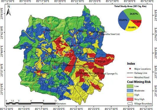
Figure 2.8 Showing coal mining risk zone index map of the study area.
2.5 Conclusion
The present study examines the hazards and their associated risk in a South Karanpura coal mining and the surrounding region. The results indicates that high and very high risk zones are present in the central, eastern, and south-eastern parts of the study area, whereas northern, southern, and western parts lie in moderate to low risk zones. About 11.35% (43.20 km 2) and 20.68% (78.96 km 2) of the area are in very high to high risk zones, whereas 33.01% (125.68 km 2) and 34.97% (133.16 km 2) of the area lay in moderate to low risk zones. The present study clearly shows that high risk zone exists in those areas, which have a coal mining industry along with a very high population. The industrial area is found to be more hazardous in comparison to coal mining and requires more focus on developing a sustainable plan to reduce the ill effect of biomass burning and allied activity that induced hazards in the area. Some active and abandoned mine fire located at Saunda, Lapanga, Bhurkunda, and Urimari needs special attention so that subsidence triggered due to sub-surface coal fires can be averted in such locations. Results of this hazard, vulnerability, and risk assessment study provide a basis from which local planers, administrators, and responders can create or update the regional district’s emergency plan, allocate resources for risk mitigation, enhance community preparedness, and prepare budgets for cost-effective on-going emergency planning. Since the nature of hazards and vulnerability conditions are similar in any coal mining region, the methodology presented in the present study can be applied to other regions.
References
1. Coal Directory of India 2012–2013, Coal Statistics. Ministry of Coal Government of India. Online available at: ( http://www.coal.nic.in/sites/upload_files/coal/files/coal-upload/coaldir-12-13.pdf); 2014 [accessed 01.05.15].
2. R. Srikanth, Sustainability of coal mining in India-Challenges and way forward (NIAS Policy Brief No. NIAS/NSE/EEP/U/PB/08/2019), 2019.
3. J.C. Hower, U.M. Graham, A.S. Wong, J.D. Robertson, B.O. Haeberlin, G.A. Thomas, and W.H. Schram, Influence of flue-gas desulfurization systems on coal combustion by-product quality at Kentucky power stations burning high-sulfur coal, Waste Management , Vol. 17(8), p. 523–533, 1998.
4. R.K Tiwary, Environmental impact of coal mining on water regime and its management, Water air and Soil Pollution , Vol.132 (1–2), p. 185–199, 2000.
5. F.G. Bell, S.E.T. Bullock, T.F.J Hälbich, and P. Lindsay, Environmental impacts associated with an abandoned mine in the Witbank Coalfield, South Africa, International journal of coal geology , Vol. 45(2–3), p. 195–216, 2001.
6. A. Prakash, and R.P. Gupta, Land-use mapping and change detection in a coal mining area-a case study in the Jharia coalfield, India, International journal of remote sensing , Vol. 19(3), p. 391–410, 1998.
7. J.G Wilson, S. Kingham, J. Pearce, and A.P. Sturman, A review of intraurban variations in particulate air pollution: Implications for epidemiological research, Atmospheric Environment , Vol. 39(34), p. 6444–6462, 2005.
8. R.R. Ranjan, H.P. Joshi, and K.N. Iyer, Spectral variation of total column aerosol optical depth over Rajkot: a tropical semi-arid Indian station, Aerosol Air Qual. Res . Vol. 7, p. 33–45, 2007.
9. A. Kumar, A.C Pandey, and M. Kumar, Evaluating variability of aerosol concentration in coal mining areas: a case study from Patratu coal mining region, Jharkhand, Conference GSI. Vol. 4, p. 119–129, 2016.
10. G.V Pawar, P.C.S Devara, S.D More, P.Kumar, and G.R Aher, Determination of aerosol characteristics and direct radiative forcing at Pune, Aerosol Air Qual. Res . Vol. 12, p. 1166–1180, 2012.
11. L. Wang, W. Gong, X. Xia, J. Zhu, J. Li, and Z. Zhu, Long-term observations of aerosol optical properties at Wuhan, an urban site in Central China, Atmos. Environ . Vol. 101, p. 94–102, 2015.
12. R.J. Charlson, and H. Rodhe, Factors controlling the acidity of natural rain-water, Nature , Vol. 295(5851), p. 683–685, 1982.
13. E.A. Kalogmomou, and N. Moussipoulous, Atmospheric linkage between climate change and air pollution. Proceedings of the Atmospheric Transport and Transformation at Urban and Local Scales-The Report of the Valencia Workshop, p. 23–33, 2005.
14. C.M. González, and B.H. Aristizábal, Acid rain and particulate matter dynamics in a mid-sized Andean city: The effect of rain intensity on ion scavenging, Atmospheric Environment , Vol. 60, p. 164–171, 2012.
15. W. Suparta, F.N. Abu Bakar, and M. Abdullah, Remote sensing of Antarctic ozone depletion using GPS meteorology, International journal of remote sensing , Vol. 34(7), p. 2519–2530, 2013.
16. A.K Jaswal, N. Kumar, A.K. Prasad, and M. Kafatos, Decline in horizontal surface visibility over India (1961-2008) and its association with meteorological variables, Natural hazards , Vol. 68(2), p. 929–954, 2013.
17. S.H. Ling, and S.F. van Eeden, Particulate matter air pollution exposure: role in the development and exacerbation of chronic obstructive pulmonary disease, International journal of chronic obstructive pulmonary disease , Vol. 4, p. 233, 2009
18. J.O. Anderson, J.G. Thundiyil, and A. Stolbach, Clearing the air: a review of the effects of particulate matter air pollution on human health, Journal of Medical Toxicology , Vol. 8(2), p. 166–175, 2012.
19. I.I. Zveryaev, and R.P. Allan, Water vapor variability in the tropics and its links to dynamics and precipitation, J. Geophys. Res. Atmos . Vol. 110 (D21), 2005.
20. T.E. Downing and K. Bakker, “Drought discourse and vulnerability,” In D.A. Wilhite, ed., Drought: a global assessment, Routledge Publishers, Vol. 2. p. 213–230, 2000.
21. A.C. Pandey, S.K. Singh, and M.S. Nathawat, Waterlogging and flood hazards vulnerability and risk assessment in Indo Gangetic plain, Natural Hazards , Vol. 55(2), p. 273–289, 2010.
22. A. Yaduvanshi, P.K. Srivastava, and A.C. Pandey, Integrating TRMM and MODIS satellite with socio-economic vulnerability for monitoring drought risk over a tropical region of India, Physics and Chemistry of the Earth , Parts A/B/C, Vol. 83, p. 14–27, 2015.
Читать дальшеИнтервал:
Закладка:
Похожие книги на «Sustainable Development Practices Using Geoinformatics»
Представляем Вашему вниманию похожие книги на «Sustainable Development Practices Using Geoinformatics» списком для выбора. Мы отобрали схожую по названию и смыслу литературу в надежде предоставить читателям больше вариантов отыскать новые, интересные, ещё непрочитанные произведения.


Обсуждение, отзывы о книге «Sustainable Development Practices Using Geoinformatics» и просто собственные мнения читателей. Оставьте ваши комментарии, напишите, что Вы думаете о произведении, его смысле или главных героях. Укажите что конкретно понравилось, а что нет, и почему Вы так считаете.