Position, Navigation, and Timing Technologies in the 21st Century
Здесь есть возможность читать онлайн «Position, Navigation, and Timing Technologies in the 21st Century» — ознакомительный отрывок электронной книги совершенно бесплатно, а после прочтения отрывка купить полную версию. В некоторых случаях можно слушать аудио, скачать через торрент в формате fb2 и присутствует краткое содержание. Жанр: unrecognised, на английском языке. Описание произведения, (предисловие) а так же отзывы посетителей доступны на портале библиотеки ЛибКат.

- Название:Position, Navigation, and Timing Technologies in the 21st Century
- Автор:
- Жанр:
- Год:неизвестен
- ISBN:нет данных
- Рейтинг книги:5 / 5. Голосов: 1
-
Избранное:Добавить в избранное
- Отзывы:
-
Ваша оценка:
Position, Navigation, and Timing Technologies in the 21st Century: краткое содержание, описание и аннотация
Предлагаем к чтению аннотацию, описание, краткое содержание или предисловие (зависит от того, что написал сам автор книги «Position, Navigation, and Timing Technologies in the 21st Century»). Если вы не нашли необходимую информацию о книге — напишите в комментариях, мы постараемся отыскать её.
Volume 1 of
contains three parts and focuses on the satellite navigation systems, technologies, and engineering and scientific applications. It starts with a historical perspective of GPS development and other related PNT development. Current global and regional navigation satellite systems (GNSS and RNSS), their inter-operability, signal quality monitoring, satellite orbit and time synchronization, and ground- and satellite-based augmentation systems are examined. Recent progresses in satellite navigation receiver technologies and challenges for operations in multipath-rich urban environment, in handling spoofing and interference, and in ensuring PNT integrity are addressed. A section on satellite navigation for engineering and scientific applications finishes off the volume.
Volume 2 of
consists of three parts and addresses PNT using alternative signals and sensors and integrated PNT technologies for consumer and commercial applications. It looks at PNT using various radio signals-of-opportunity, atomic clock, optical, laser, magnetic field, celestial, MEMS and inertial sensors, as well as the concept of navigation from Low-Earth Orbiting (LEO) satellites. GNSS-INS integration, neuroscience of navigation, and animal navigation are also covered. The volume finishes off with a collection of work on contemporary PNT applications such as survey and mobile mapping, precision agriculture, wearable systems, automated driving, train control, commercial unmanned aircraft systems, aviation, and navigation in the unique Arctic environment.
In addition, this text:
Serves as a complete reference and handbook for professionals and students interested in the broad range of PNT subjects Includes chapters that focus on the latest developments in GNSS and other navigation sensors, techniques, and applications Illustrates interconnecting relationships between various types of technologies in order to assure more protected, tough, and accurate PNT
will appeal to all industry professionals, researchers, and academics involved with the science, engineering, and applications of position, navigation, and timing technologies.pnt21book.com
Position, Navigation, and Timing Technologies in the 21st Century — читать онлайн ознакомительный отрывок
Ниже представлен текст книги, разбитый по страницам. Система сохранения места последней прочитанной страницы, позволяет с удобством читать онлайн бесплатно книгу «Position, Navigation, and Timing Technologies in the 21st Century», без необходимости каждый раз заново искать на чём Вы остановились. Поставьте закладку, и сможете в любой момент перейти на страницу, на которой закончили чтение.
Интервал:
Закладка:
Radio SLAM ModeThe cellular‐aided INS framework enters a radio SLAM mode when GNSS pseudoranges become unavailable. In this mode, INS errors are corrected using cellular pseudoranges and the cellular transmitters’ state estimates that were last computed in the mapping mode. As the vehicle navigates, it continues to refine the cellular transmitters’ state estimates simultaneously with estimating the vehicle’s own states.
Figure 38.64illustrates a high‐level diagram of the cellular‐aided INS framework.
38.9.2 Simulation Results
To demonstrate the performance of the cellular‐aided INS framework, simulations were conducted of a UAV equipped with cellular navigation receivers, navigating in downtown Los Angeles, California, while listening to ambient cellular signals. Two navigation systems were employed to estimate the trajectory of the UAV: (i) a traditional tightly coupled GPS‐aided INS with a tactical‐grade IMU and (ii) the cellular‐aided INS discussed in Section 38.9.1with a consumer‐grade IMU. A simulator generated the true trajectory of the UAV and clock error states of the UAV‐mounted receiver, the cellular transmitters’ clock error states, noise‐corrupted IMU measurements of specific force and angular rates, and noise‐corrupted pseudoranges to multiple cellular towers and GPS SVs. The IMU signal generator used a triad gyroscope and a triad accelerometer model, each with time‐evolving biases that provided sampled data at 100 Hz. GPS L1 C/A pseudoranges were generated at 1 Hz using SV orbits produced from receiver‐independent exchange files downloaded on October 22, 2016, from a continuously operating reference station server [90]. The GPS L1 C/A pseudoranges were set to be available for only the first 100 s of the 200 s simulation. Cellular pseudoranges were generated at 5 Hz to four cellular towers, which were surveyed from real tower positions in downtown Los Angeles. The UAV’s true trajectory included a straight segment followed by two banked orbits in the vicinity of the four cellular towers, shown in Figure 38.65(a). The resulting EKF estimation errors and corresponding three standard deviation bounds for the north and east position of the UAV are plotted in Figure 38.65(b). The navigation solutions from using (i) the cellular‐aided INS and (ii) only an INS during the 100 s GPS pseudoranges were unavailable appear in Figure 38.65(c). The final tower estimated position and corresponding 95th‐percentile estimation uncertainty ellipse is shown in Figure 38.65(d). One can see that when GPS pseudoranges became unavailable at 100 s, the estimation errors associated with the traditional GPS‐aided INS integration strategy began to diverge, as expected, whereas the errors associated with the cellular‐aided INS were bounded within this 100 s duration of GPS unavailability. Furthermore, when GPS was still available during the first 100 s, the cellular‐aided INS with a consumer‐grade IMU almost always produced lower estimation error uncertainties when compared to the traditional GPS‐aided INS integration strategy with a tactical‐grade IMU.
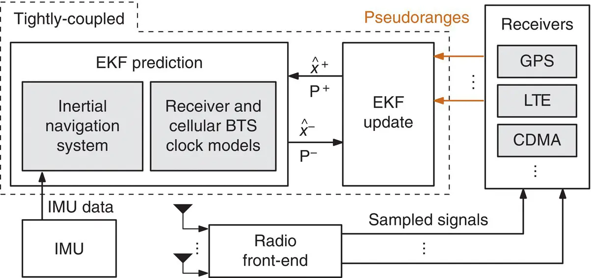
Figure 38.64 Tightly coupled cellular‐aided INS framework (Kassas et al. [4]).
Source: Reproduced with permission of Z. Kassas.
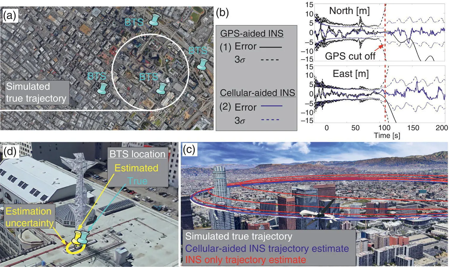
Figure 38.65 Illustration of simulation results for a UAV flying over downtown Los Angeles, California. (a) Simulated true trajectory (white curve) and cellular tower locations (blue pins). (b) EKF estimation errors and corresponding 3 standard deviation bounds (3 σ ) of the north and east position states of the UAV. (c) Unaided INS navigation solution (red curve), and cellular‐aided INS navigation solution (blue curve) during the GPS outage. (d) True and estimated tower location and estimation uncertainty ellipse. Map data: Google Earth (Kassas et al. [4]).
Source: Reproduced with permission of Z. Kassas.
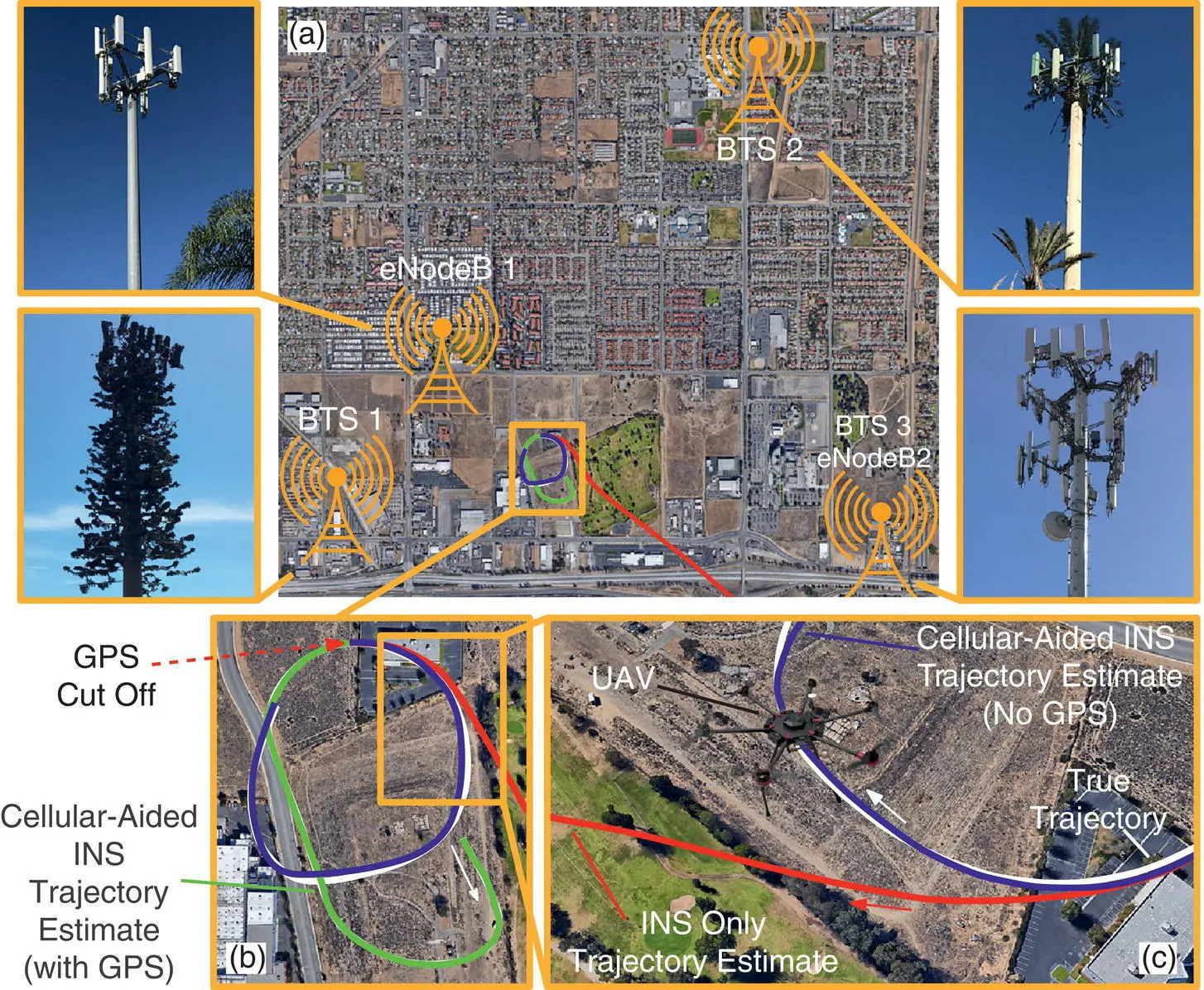
Figure 38.66 Experimental results of a UAV aiding its INS with cellular signals in the absence of GPS signals. (a) Cellular environment comprising three CDMA BTSs and two LTE eNodeBs. (b) UAV’s estimated trajectories: white: true trajectory, green: cellular‐aided INS with GPS (before GPS cutoff), red: INS only (after GPS cutoff), and blue: cellular‐aided INS (after GPS cutoff). (c) Zoom on the UAV’s diverging INS trajectory after GPS cutoff.
Map data: Google Earth (Kassas et al. [4]). Source: Reproduced with permission of Z. Kassas.
38.9.3 Experimental Results
To demonstrate the performance of the cellular‐aided INS, a UAV was flown in an environment comprising three cellular CDMA BTSs and two LTE eNodeBs, whose locations were pre‐surveyed and are illustrated in Figure 38.66(a) [6]. The UAV was equipped with a consumer‐grade IMU, a GPS receiver, and the cellular CDMA and LTE navigation receivers discussed in Sections 38.5and 38.6. Experimental results are presented for two scenarios: (i) the cellular‐aided INS described in Sub section 38.9.1and (ii) for comparative analysis, a traditional GPS‐aided INS using the UAV’s IMU. The true trajectory traversed by the UAV is plotted in Figures 38.66(b)–(c) and consists of GPS unavailability for 50 s, starting at a location marked by the red arrow. The north‐east RMSE of the GPS‐aided INS’s navigation solution after GPS became unavailable was more than 100 m. The UAV also estimated its trajectory using the cellular‐aided INS framework using signals from the three CDMA BTSs and two eNodeBs to aid its onboard INSs. Table 38.7summarizes the UAV’s 2D and 3D RMSEs and final errors.
Table 38.7 UAV’s RMSEs and final errors after 50 s of GPS cutoff
 |
2–D RMSE (m) | 3–D RMSE (m) | Final 3–D error (m) |
|---|---|---|---|
| INS only | >100 | >100 | >100 |
| Cellular‐aided INS | 4.68 | 7.76 | 4.92 |
References
1 1 M. Bshara, U. Orguner, F. Gustafsson, and L. Van Biesen, “Robust tracking in cellular networks using HMM filters and cell‐ID measurements,” IEEE Transactions on Vehicular Technology, vol. 60, no. 3, pp. 1016–1024, March 2011.
2 2 C. Yang, T. Nguyen, and E. Blasch, “Mobile positioning via fusion of mixed signals of opportunity,” IEEE Aerospace and Electronic Systems Magazine, vol. 29, no. 4, pp. 34–46, April 2014.
3 3 M. Ulmschneider and C. Gentner, “Multipath assisted positioning for pedestrians using LTE signals,” in Proceedings of IEEE/ION Position, Location, and Navigation Symposium, April 2016, pp. 386–392.
4 4 Z. Kassas, J. Morales, K. Shamaei, and J. Khalife, “LTE steers UAV,” GPS World Magazine, vol. 28, no. 4, pp. 18–25, April 2017.
5 5 M. Driusso, C. Marshall, M. Sabathy, F. Knutti, H. Mathis, and F. Babich, “Vehicular position tracking using LTE signals,” IEEE Transactions on Vehicular Technology, vol. 66, no. 4, pp. 3376–3391, April 2017.
6 6 Z. Kassas, J. Khalife, K. Shamaei, and J. Morales, “I hear, therefore I know where I am: Compensating for GNSS limitations with cellular signals,” IEEE Signal Processing Magazine, pp. 111–124, September 2017.
Читать дальшеИнтервал:
Закладка:
Похожие книги на «Position, Navigation, and Timing Technologies in the 21st Century»
Представляем Вашему вниманию похожие книги на «Position, Navigation, and Timing Technologies in the 21st Century» списком для выбора. Мы отобрали схожую по названию и смыслу литературу в надежде предоставить читателям больше вариантов отыскать новые, интересные, ещё непрочитанные произведения.


Обсуждение, отзывы о книге «Position, Navigation, and Timing Technologies in the 21st Century» и просто собственные мнения читателей. Оставьте ваши комментарии, напишите, что Вы думаете о произведении, его смысле или главных героях. Укажите что конкретно понравилось, а что нет, и почему Вы так считаете.