Position, Navigation, and Timing Technologies in the 21st Century
Здесь есть возможность читать онлайн «Position, Navigation, and Timing Technologies in the 21st Century» — ознакомительный отрывок электронной книги совершенно бесплатно, а после прочтения отрывка купить полную версию. В некоторых случаях можно слушать аудио, скачать через торрент в формате fb2 и присутствует краткое содержание. Жанр: unrecognised, на английском языке. Описание произведения, (предисловие) а так же отзывы посетителей доступны на портале библиотеки ЛибКат.

- Название:Position, Navigation, and Timing Technologies in the 21st Century
- Автор:
- Жанр:
- Год:неизвестен
- ISBN:нет данных
- Рейтинг книги:5 / 5. Голосов: 1
-
Избранное:Добавить в избранное
- Отзывы:
-
Ваша оценка:
Position, Navigation, and Timing Technologies in the 21st Century: краткое содержание, описание и аннотация
Предлагаем к чтению аннотацию, описание, краткое содержание или предисловие (зависит от того, что написал сам автор книги «Position, Navigation, and Timing Technologies in the 21st Century»). Если вы не нашли необходимую информацию о книге — напишите в комментариях, мы постараемся отыскать её.
Volume 1 of
contains three parts and focuses on the satellite navigation systems, technologies, and engineering and scientific applications. It starts with a historical perspective of GPS development and other related PNT development. Current global and regional navigation satellite systems (GNSS and RNSS), their inter-operability, signal quality monitoring, satellite orbit and time synchronization, and ground- and satellite-based augmentation systems are examined. Recent progresses in satellite navigation receiver technologies and challenges for operations in multipath-rich urban environment, in handling spoofing and interference, and in ensuring PNT integrity are addressed. A section on satellite navigation for engineering and scientific applications finishes off the volume.
Volume 2 of
consists of three parts and addresses PNT using alternative signals and sensors and integrated PNT technologies for consumer and commercial applications. It looks at PNT using various radio signals-of-opportunity, atomic clock, optical, laser, magnetic field, celestial, MEMS and inertial sensors, as well as the concept of navigation from Low-Earth Orbiting (LEO) satellites. GNSS-INS integration, neuroscience of navigation, and animal navigation are also covered. The volume finishes off with a collection of work on contemporary PNT applications such as survey and mobile mapping, precision agriculture, wearable systems, automated driving, train control, commercial unmanned aircraft systems, aviation, and navigation in the unique Arctic environment.
In addition, this text:
Serves as a complete reference and handbook for professionals and students interested in the broad range of PNT subjects Includes chapters that focus on the latest developments in GNSS and other navigation sensors, techniques, and applications Illustrates interconnecting relationships between various types of technologies in order to assure more protected, tough, and accurate PNT
will appeal to all industry professionals, researchers, and academics involved with the science, engineering, and applications of position, navigation, and timing technologies.pnt21book.com
Position, Navigation, and Timing Technologies in the 21st Century — читать онлайн ознакомительный отрывок
Ниже представлен текст книги, разбитый по страницам. Система сохранения места последней прочитанной страницы, позволяет с удобством читать онлайн бесплатно книгу «Position, Navigation, and Timing Technologies in the 21st Century», без необходимости каждый раз заново искать на чём Вы остановились. Поставьте закладку, и сможете в любой момент перейти на страницу, на которой закончили чтение.
Интервал:
Закладка:
Michael J. Veth Veth Research Associates, United States
Todd Walter Stanford University, United States
Shimon Wdowinski Florida International University, United States
David Whelan University of California San Diego, United States
Walton Williamson Jet Propulsion Laboratory, United States
Chun Yang Sigtem Technology Inc., United States
Rong Yang Shanghai Jiaotong University, China
Zhe Yang University of Colorado Boulder, United States
Zheng Yao Tsinghua University, China
Steven Young National Aeronautics and Space Administration, United States
Valery U. Zavorotny University of Colorado Boulder, and National Oceanic and Atmospheric Administration, United States
Zhen Zhu East Carolina University, United States
35 Overview of Volume 2: Integrated PNT Technologies and Applications
John F. Raquet
Integrated Solutions for Systems, United States
There is little doubt that global navigation satellite systems (GNSS) have changed the way that we think about and use navigation systems. Prior to GPS and other GNSSs, the use of systems which could automatically (without human intervention) determine their own position was generally limited to large, expensive platforms such as aircraft or ships, and even these types of vehicles often required human navigators to assist in the task of navigation. This has all changed with the advent of GNSS, however.
Thanks to GNSS, most people have now become accustomed to their smartphone or vehicle knowing exactly where it is as a part of their everyday lives, and this capability has been built into our expectations. Just as we expect the lights to come on when we turn on a light switch, we also expect a GNSS position fix whenever we turn on a smartphone or other navigation device. This reliance on GNSS goes well beyond obvious navigation devices – we very much depend on many systems which heavily use GNSS for timing purposes, such as banking, communications, and our power grid.
Some have said that navigation is addictive – no matter how much accuracy or availability you have, you always want more. The extreme success of GNSS has, ironically, led to a desire to complement GNSS with other types of sensors for situations in which GNSS is not available, in order to guarantee (as much as is possible) the ability to determine time or position.
Volume 2 focuses in on many of these complementary navigation systems and methods and how they are integrated together to obtain the desired performance. Before diving into the details, it can be helpful to step back and look at the big picture of what is really happening within navigation systems, in order to better understand how the various approaches relate to each other. To do this, it is helpful to develop a “navigation framework.”
35.1 Generalized Navigation Framework
Fundamentally, virtually every navigation system operates the same way. This can be expressed as a predict–observe–compare cycle, as shown in Figure 35.1. The “Navigation State” at the lower right represents the user’s current navigation state, or all of the information about the user’s position, velocity, and so on, as well as estimates of that information’s quality. This can be thought of as the system’s best guess of the user’s position as well as how accurate the system thinks the guess is. As depicted in the “Sensor” box on the left, the system takes a measurement or makes an observation which gives some insight into the user’s navigation state. For GPS, perhaps the system observes the range to a satellite. The system also uses a model of the real world, depicted with the “World Model” box in the upper right. In the case of GPS, the world model might consist of the locations (orbits) of the GPS satellites.
During the predict phase, the prediction algorithm determines what the system expects to observe based upon the world model and the current navigation state, annotated as the “Prediction Algorithm” box in Figure 35.1. During the observe phase, the system receives a noise‐corrupted measurement from the real world. During the compare phase, the predicted measurement is compared to the actual measurement. Any discrepancies are used to improve the navigation state and possibly the model of the world.
Consider a simplified example in which a user attempts to determine the distance to a wall. Perhaps the user predicts the distance to the wall is about 30 feet based upon mere eyesight to judge the distance. (The navigation state is 30 feet with much uncertainty.) Then, suppose a precise laser range finder is used to measure, or observe, the distance as 31.2 feet. Next, the prediction is compared to the observation. The user quickly dismisses the prediction and trusts the observation, because the user observation was viewed as being a more reliable estimate of distance than the prediction. Likewise, examples could be drawn which highlight the prediction heavily outweighing an observation.
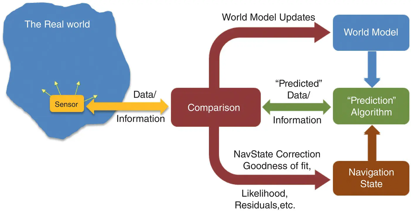
Figure 35.1 General navigation framework.
The most interesting applications involve a blending of the prediction with the observation. Typical GPS applications use a Kalman filter to perform the predict–observe–compare cycle. The world model consists of GPS satellite locations. Based upon some prior information, the receiver predicts the user’s location. The observations might consist of ranges to each satellite in view. These observations are compared to a prediction of what the ranges should be based upon the receiver’s estimate of position (and assumed knowledge of the world). The system conducts a blended comparison based upon the relative quality of the predicted navigation state and the observations.
In Figure 35.1, the arrow labeled “world model updates” indicates that the world model can be changed based upon the measurements that have been taken. Some navigation systems, particularly those which are designed and deployed specifically for navigation, do not require the end user of the system to be involved in this part of the process. For example, in GPS, the world model consists of information about the satellite orbits (ephemeris), the satellite clock errors, and details that are given in the signal specification (frequency, chipping rate, etc.). The GPS system uses its own receiver network on the ground to estimate satellite orbits and clock errors and to monitor the signals coming from space, and measurements from this network are used to continually update the GPS world model. As a result, the user simply obtains the most recent ephemeris and satellite clock terms and uses them for positioning. In this way, the user is completely uninvolved in the updating of the world model, which is helpful, because it greatly reduces the complexity of the system for the user.
Unlike man‐made signals, natural signals do not generally have a dedicated part of the system that is continually updating a concise world model which describes how sensed measurements relate to the real world. As a result, the challenge with such systems is often to determine a usable world model. For example, it is very easy to obtain images of the nearby environment using a camera. However, in order to determine position and/or attitude from this kind of measurement, the user must have knowledge of what the world looks like as a function of position and attitude (the world model).
Читать дальшеИнтервал:
Закладка:
Похожие книги на «Position, Navigation, and Timing Technologies in the 21st Century»
Представляем Вашему вниманию похожие книги на «Position, Navigation, and Timing Technologies in the 21st Century» списком для выбора. Мы отобрали схожую по названию и смыслу литературу в надежде предоставить читателям больше вариантов отыскать новые, интересные, ещё непрочитанные произведения.


Обсуждение, отзывы о книге «Position, Navigation, and Timing Technologies in the 21st Century» и просто собственные мнения читателей. Оставьте ваши комментарии, напишите, что Вы думаете о произведении, его смысле или главных героях. Укажите что конкретно понравилось, а что нет, и почему Вы так считаете.