James Mooney - Native Americans - 22 Books on History, Mythology, Culture & Linguistic Studies
Здесь есть возможность читать онлайн «James Mooney - Native Americans - 22 Books on History, Mythology, Culture & Linguistic Studies» — ознакомительный отрывок электронной книги совершенно бесплатно, а после прочтения отрывка купить полную версию. В некоторых случаях можно слушать аудио, скачать через торрент в формате fb2 и присутствует краткое содержание. Жанр: unrecognised, на английском языке. Описание произведения, (предисловие) а так же отзывы посетителей доступны на портале библиотеки ЛибКат.
- Название:Native Americans: 22 Books on History, Mythology, Culture & Linguistic Studies
- Автор:
- Жанр:
- Год:неизвестен
- ISBN:нет данных
- Рейтинг книги:4 / 5. Голосов: 1
-
Избранное:Добавить в избранное
- Отзывы:
-
Ваша оценка:
Native Americans: 22 Books on History, Mythology, Culture & Linguistic Studies: краткое содержание, описание и аннотация
Предлагаем к чтению аннотацию, описание, краткое содержание или предисловие (зависит от того, что написал сам автор книги «Native Americans: 22 Books on History, Mythology, Culture & Linguistic Studies»). Если вы не нашли необходимую информацию о книге — напишите в комментариях, мы постараемся отыскать её.
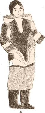
"Native American Studies" is an interdisciplinary collection which examines the history, culture, religion and language of indigenous people in North America. This meticulously edited collection explores the life of the biggest Native American tribes; including: Cherokee, Iroquois, Sioux, Navajo, Zuñi, Apache, Seminole and Eskimo.
Contents:
History:
The North American Indian
The Cherokee Nation of Indians
The Seminole Indians of Florida
The Central Eskimo
The Siouan Indians
Calendar History of the Kiowa Indians
Legends, Traditions and Laws of the Iroquois and History of the Tuscarora Indians
History, Manners and Customs of the Indian Nations Who Once Inhabited Pennsylvania and the Neighboring States
Military History:
Chronicles of Border Warfare – Indian Wars in West Virginia
Autobiography of the Sauk Leader Black Hawk and the History of the Black Hawk War of 1832
The Vanishing Race – The Last Great Indian Council
Myths & Legends
The Myths of the North American Indians
Myths of the Cherokee
Myths of the Iroquois
A Study of Siouan Cults
Outlines of Zuñi Creation Myths
The Mountain Chant – A Navajo Ceremony
Language:
Indian Linguistic Families Of America
Sign Language Among North American Indians
Pictographs of the North American Indians
Customs:
Burial Mounds of the Northern Sections of the United States
The Medicine-Men of the Apachee
Native Americans: 22 Books on History, Mythology, Culture & Linguistic Studies — читать онлайн ознакомительный отрывок
Ниже представлен текст книги, разбитый по страницам. Система сохранения места последней прочитанной страницы, позволяет с удобством читать онлайн бесплатно книгу «Native Americans: 22 Books on History, Mythology, Culture & Linguistic Studies», без необходимости каждый раз заново искать на чём Вы остановились. Поставьте закладку, и сможете в любой момент перейти на страницу, на которой закончили чтение.
Интервал:
Закладка:
| Greenland. | Baffin Land. | |
|---|---|---|
| Transformation of a man into a seal. | Rink, pp. 222, 224, 469. | Kiviung, p. 621. |
| Men walking on the surface of the water. | Rink, pp. 123, 407. | Kiviung, p. 622. |
| Harpooning a witch. | Rink, p. 372. | Sedna, p. 604. |
| Erqigdlit. | Rink, pp. 401 et seq. | Adlet, p. 637. |
| Sledge of the man of the moon drawn by one dog. | Rink, pp. 401, 442. | Qaudjaqdjuq, p. 631, and The flight to the moon, p. 598. |
| Origin of the salmon. | Cranz, p. 262. | Ititaujang, p. 617. |
| Arnaquagsaq. | Rink, pp. 150, 326, 466. | Sedna, p. 583. |
| Origin of the thunder. | Cranz, p. 233; Egede, p. 207. | Kadlu, p. 600. |
The following is a comparison between traditions from Alaska and the Mackenzie and those of the Central Eskimo:
| Traditions from Alaska and the Mackenzie: | Traditions of the Central Eskimo: |
|---|---|
| Men as descendants of a dog, Murdoch, op. cit., 594. | Origin of the Adlet and white men, p. 637. |
| The origin of reindeer, Murdoch, op. cit., p. 595. | Origin of the reindeer and walrus, p. 587. |
| The origin of the fishes, Murdoch, op. cit., p. 595. | Ititaujang, p. 617. |
| Thunder and lightning, Murdoch, op. cit., p. s595. | Kadlu the thunderer, p. 600. |
| Sun and moon, Petitot, op. cit., p. 7. | Sun and moon, p. 597. |
| Orion, Simpson, p. 940. | Orion, p. 636. |
The table shows that the following ideas are known to all tribes from Alaska to Greenland: The sun myth, representing the sun as the brother of the moon; the legend of the descent of man from a dog; the origin of thunder by rubbing a deerskin; the origin of fish from chips of wood; and the story of the origin of deer.
It must be regretted that very few traditions have as yet been collected in Alaska, as the study of such material would best enable us to decide upon the question of the origin of the Eskimo.
Science and the Arts
Table of Contents
Geography and Navigation
Table of Contents
The Eskimo exhibit a thorough knowledge of the geography of their country. I have already treated of their migrations and mentioned that the area they travel over is of considerable extent. They have a very clear conception of all the countries they have seen or heard of, knowing the distances by day’s journeys, or, as they say, by sleeps, and the directions by the cardinal points. So far as I know, all these tribes call true south piningnang, while the other points are called according to the weather prevailing while the wind blows from the different quarters. In Cumberland Sound uangnang is west-northwest; qaningnang (that is, snow wind), east-northeast; nigirn, southeast; and aqsardnirn, the fohn-like wind blowing from the fjords of the east coast. On Nettilling these names are the same, the east-northeast only being called qanara (that is, is it snow?) In Akudnirn uangnang is west-southwest; ikirtsuq (i.e., the wind of the open sea), east-northeast; oqurtsuq (i.e., the wind of the land Oqo or of the lee side, southeast; and avangnanirn (i.e., from the north side along the shore), the northwestern gales. According to Parry the same names as in Cumberland Sound are used in Iglulik.
If the weather is clear the Eskimo use the positions of the sun, of the dawn, or of the moon and stars for steering, and find their way pretty well, as they know the direction of their point of destination exactly. If the weather is thick they steer by the wind, or, if it is calm, they do not travel at all. After a gale they feel their way by observing the direction of the snowdrifts.
They distinguish quite a number of constellations, the most important of which are Tuktuqdjung (the deer), our Ursa Major; the Pleiades, Sakietaun; and the belt of Orion, Udleqdjun.
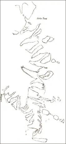
CUMBERLAND PENINSULA, DRAWN BY ARANIN, A SAUMINGNIO.
ESKIMO DRAWINGS.
As their knowledge of all the directions is very detailed and they are skillful draftsmen they can draw very good charts. If a man intends to visit a country little known to him, he has a map drawn in the snow by some one well acquainted there and these maps are so good that every point can be recognized. Their way of drawing is first to mark some points the relative positions of which are well known. They like to stand on a hill and to look around in order to place these correctly. This done, the details are inserted. It is remarkable that their ideas of the relative position and direction of coasts far distant one from another are so very clear. Copies of some charts drawn by Eskimo of Cumberland Sound and Davis Strait are here introduced (Plate IV, p. 643, and Figs. 543–546). A comparison between the maps and these charts will prove their correctness. Frequently the draftsman makes his own country, with which he is best acquainted, too large; if some principal points are marked first, he will avoid this mistake. The distance between the extreme points represented in the first chart (Fig. 543) is about five hundred miles.
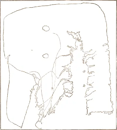
Fig. 543. Cumberland Sound and Frobisher Bay, drawn by Itu, a Nugumio.
(Original in the Museum für Völkerkunde, Berlin.)

Fig. 544. Cumberland Sound and Frobisher Bay, drawn by Sunapignang, an Oqomio.
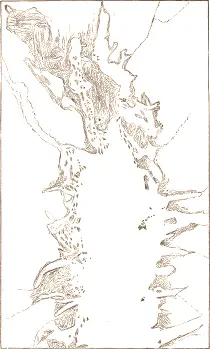
Fig. 545. Cumberland Sound, drawn by Itu, a Nugumio.
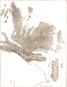
Fig. 546. Peninsula of Qivitung, drawn by Angutuqdjuaq, a Padlimio.
The Eskimo have a sort of calendar. They divide the year into thirteen months, the names of which vary a great deal, according to the tribes and according to the latitude of the place. The surplus is balanced by leaving out a month every few years, to wit, the month siringilang (without sun), which is of indefinite duration, the name covering the whole time of the year when the sun does not rise and there is scarcely any dawn. Thus every few years this month is totally omitted, when the new moon and the winter solstice coincide. The name qaumartenga is applied only to the days without sun but with dawn, while the rest of the same moon is called siriniktenga. The days of the month are very exactly designated by the age of the moon. Years are not reckoned for a longer space than two, backward and forward.

a , b , c , e Drawn by Aisē´ang, a native of Nuvujen.
Читать дальшеИнтервал:
Закладка:
Похожие книги на «Native Americans: 22 Books on History, Mythology, Culture & Linguistic Studies»
Представляем Вашему вниманию похожие книги на «Native Americans: 22 Books on History, Mythology, Culture & Linguistic Studies» списком для выбора. Мы отобрали схожую по названию и смыслу литературу в надежде предоставить читателям больше вариантов отыскать новые, интересные, ещё непрочитанные произведения.


Обсуждение, отзывы о книге «Native Americans: 22 Books on History, Mythology, Culture & Linguistic Studies» и просто собственные мнения читателей. Оставьте ваши комментарии, напишите, что Вы думаете о произведении, его смысле или главных героях. Укажите что конкретно понравилось, а что нет, и почему Вы так считаете.