Hilaire Belloc - The Collected Works of Hilaire Belloc
Здесь есть возможность читать онлайн «Hilaire Belloc - The Collected Works of Hilaire Belloc» — ознакомительный отрывок электронной книги совершенно бесплатно, а после прочтения отрывка купить полную версию. В некоторых случаях можно слушать аудио, скачать через торрент в формате fb2 и присутствует краткое содержание. Жанр: unrecognised, на английском языке. Описание произведения, (предисловие) а так же отзывы посетителей доступны на портале библиотеки ЛибКат.
- Название:The Collected Works of Hilaire Belloc
- Автор:
- Жанр:
- Год:неизвестен
- ISBN:нет данных
- Рейтинг книги:5 / 5. Голосов: 1
-
Избранное:Добавить в избранное
- Отзывы:
-
Ваша оценка:
The Collected Works of Hilaire Belloc: краткое содержание, описание и аннотация
Предлагаем к чтению аннотацию, описание, краткое содержание или предисловие (зависит от того, что написал сам автор книги «The Collected Works of Hilaire Belloc»). Если вы не нашли необходимую информацию о книге — напишите в комментариях, мы постараемся отыскать её.
Nonfiction:
History
The Book of the Bayeux Tapestry
The Path to Rome
The Old Road
The French Revolution
Blenheim
Tourcoing
Crécy
Waterloo
Malplaquet
Poitiers
First and Last
Europe and the Faith
Survivals and New Arrivals: The Old and New Enemies of the Catholic Church
The Jews
The Historic Thames
A Change in the Cabinet
A General Sketch of the European War: The First Phase
The Two Maps of Europe
Economics
Servile State
Essays:
Avril: Essays on the Poetry of the French Renaissance
Hills and the Sea
On Nothing and Kindred Subjects
On Everything
On Anything
On Something
This and That
On
The Free Press
Fiction:
Novels & Short Stories
The Mercy of Allah
The Green Overcoat
Poetry:
A Moral Alphabet
Bad Child's Book of Beasts
More Beasts For Worse Children
The Modern Traveller
Cautionary Tales for Children
More Peers
The Collected Works of Hilaire Belloc — читать онлайн ознакомительный отрывок
Ниже представлен текст книги, разбитый по страницам. Система сохранения места последней прочитанной страницы, позволяет с удобством читать онлайн бесплатно книгу «The Collected Works of Hilaire Belloc», без необходимости каждый раз заново искать на чём Вы остановились. Поставьте закладку, и сможете в любой момент перейти на страницу, на которой закончили чтение.
Интервал:
Закладка:
Beyond the grounds of Netley House the Old Road is entirely lost. A great ploughed field has destroyed every trace of it, but the direction is quite easy to follow when one notes the alignment which it pursues upon its reappearance above the line of cultivation. It must have run, at first, due north-west, and turned more and more westward as it neared Colekitchen Lane: it must have crossed the mouth of Colekitchen Combe, which here runs into the hills, and have reached in this fashion the 400-feet contour-line at the corner of Hacklehurst Down, where we come on it just at the far edge of the Combe, on the shoulder about three hundred yards east of the rough lane which leads up from under the railway arch to the Downs. 24
From this point we could follow it mile after mile without any difficulty. Its platform is nearly always distinct; the yews follow it in a continual procession, though it is cut here and there by later roads. The old quarries and chalk pits which mark it henceforward continually along the way to Canterbury begin to appear, and it does not fail one all along the hill and the bottom of Denbies Park until, at the end of that enclosure, it is lost in the pit of the Dorking Lime Works. It does not reappear. Beyond there is a considerable gap—nearly a mile in length—before it can reach the river Mole, which it must cross in order to pursue its journey. With this gap I shall deal in a moment, but it was the affair of our next day's journey, for short as had been the distance from Shalford, the many checks and the seeking here and there which they had entailed had exhausted the whole of the short daylight. The evening had come when we stood on the Down looking over to Box Hill beyond.
From thence across the valley, Box Hill attracted and held the sight as one looked eastward: the strongest and most simple of our southern hills. It stood out like a cape along our coasting journey, our navigation of the line of the Downs. The trend of the range is here such that the clean steep of this promontory hides the slopes to the east. It occupies the landscape alone.
It has been debated and cannot be resolved, why these great lines of chalk north and south of the Weald achieve an impression of majesty. They are not very high. Their outline is monotonous and their surface bare. Something of that economy and reserve by whose power the classic in verse or architecture grows upon the mind is present in the Downs. These which we had travelled that day were not my own hills—Duncton and Bury, Westburton, Amberley and all—but they were similar because they stood up above the sand and the pines, and because they were of that white barren soil, clothed in close turf, wherein nothing but the beech, the yew, and our own affection can take root and grow.
At the end of a day's work, a short winter day's, it was possible to separate this noble mark of what was once a true county of Surrey; to separate it even in the mind, from the taint of our time and the decay and vileness which hang like a smell of evil over whatever has suffered the influence of our great towns. The advancing darkness which we face restored the conditions of an older time; the staring houses merged with the natural trees; a great empty sky and a river mist gave the illusion of a place unoccupied.
It was possible to see the passage of the Mole as those rare men saw it who first worked their way eastward to the Straits, and had not the suggestion seemed too fantastic for a sober journey of research, one might have taken the appeal of the hills for a kind of guide; imagining that with such a goal the trail would plunge straight across the valley floor to reach it.
By more trustworthy methods, the track of the Old Road was, as I have said, less ascertainable. Presumably it followed, down the shoulder of the hill, a spur leading to the river, but the actual mark of the road was lost, its alignment soon reached ploughed land; nothing of the place of crossing could be determined till the stream itself was examined, nor indeed could we make sure of the true point until we found ourselves unexpectedly aided by the direction of the road when we recovered it upon the further bank. This we left for the dawn of the next day; and so went down into Dorking to sleep.
I have said that from Denbies, or rather from the pits of Dorking Lime Works, the path is apparently lost. It reappears, clearly enough marked, along the lower slope of Box Hill, following the 300-feet contour-line; but between the two points is a gap extending nearly a mile on one side of the river and almost half a mile upon the other.
I have seen it conjectured that the Old Road approached the Mole near Burford, and that it turned sharply up over Ranmore Common on its way. That it crossed Ranmore Common is impossible. Undoubtedly a prehistoric track ran over that heath, but it was a branch track to the Thames—one of the many 'feeders' which confuse the record of the Old Road. But that it crossed at Burford Bridge is arguable.
The name Burford suggests the crossing of the river. The pilgrims undoubtedly passed here, going down Westhumble Lane, and using the bridge—for everybody uses a bridge once it has been built. Thence they presumably followed along the western flank of Box Hill, and so round its base to that point where, as I have said, the embankment and the old trees reappear.
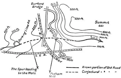
Nevertheless, those who imagine that the original road, the prehistoric track, followed this course, were, we thought, in error. We had little doubt that, after the lime pit outside Denbies Park, the road followed down the moderate shoulder or spur which here points almost directly eastward towards the valley, crossed the railway just north of the road bridge over the line, approached the Mole at a point due east of this, and immediately ascended the hill before it to that spot where it distinctly reappears: a spot near the 300-feet contour-line somewhat to the west of the lane leading from the Reigate Road to the crest of the hills. 25

IT STOOD OUT LIKE A CAPE ALONG OUR COASTING JOURNEY, OUR NAVIGATION OF THE LINE OF THE DOWNS
I will give my reasons for this conclusion.
A diversion round by Burford Bridge would have taken the early travellers far out of their way. Roughly speaking, they would have had to go along two sides of an equilateral triangle instead of its base: three miles for one and a half. Now, had they any reason to do this? None that I can see. Wherever, in crossing a valley, the Old Road diverges from its general alignment, it diverges either to avoid bad soil or to find a ford. The name Burford would suggest to those who have not carefully examined the river that this diversion might have been made necessary in order to find a shoal at that point; but the Mole is very unlike the other streams south of the Thames. It disappears into 'swallows': it 'snouzles,' and there is a theory that the river got its name from this habit of burrowing underground. At almost any one of these numerous 'swallows' the river can quite easily be crossed, and a considerable diminution of its stream, though perhaps not a true 'swallow,' is to be found at the point I indicate.
Again, that all-important consideration in a new country—I mean the dryness of the soil over which a road passes—was very much helped by taking the more direct of the two lines. Ground with some slope to it, and always fairly dry, comes here on either side, close to the river. But down by Burford, on the western side, there is quite a little plain, which must have been marshy, and for all I know, may be so still. Moreover, we shall find further on at Otford, and at Snodland, that the Old Road in crossing a valley always chooses a place where some spur of high land leads down to the river and corresponds to a dry rise immediately upon the other bank. Coupled with the fact that a direction such as I suggest makes a natural link between the two known parts of the road, being very nearly in one alignment with them, and remembering that Burford Bridge was built in connection with a very much later Roman way northward up the valley (it is evidently the Bridge of the Stane Street), that its direction and the place at which it crosses are obviously dependent on a north and south road, not on an east and west one, we decided to approach the eastern bank, and to see whether any existing trace of a road would support what seemed to us the most tenable hypothesis.
Читать дальшеИнтервал:
Закладка:
Похожие книги на «The Collected Works of Hilaire Belloc»
Представляем Вашему вниманию похожие книги на «The Collected Works of Hilaire Belloc» списком для выбора. Мы отобрали схожую по названию и смыслу литературу в надежде предоставить читателям больше вариантов отыскать новые, интересные, ещё непрочитанные произведения.


Обсуждение, отзывы о книге «The Collected Works of Hilaire Belloc» и просто собственные мнения читателей. Оставьте ваши комментарии, напишите, что Вы думаете о произведении, его смысле или главных героях. Укажите что конкретно понравилось, а что нет, и почему Вы так считаете.