Hilaire Belloc - The Collected Works of Hilaire Belloc
Здесь есть возможность читать онлайн «Hilaire Belloc - The Collected Works of Hilaire Belloc» — ознакомительный отрывок электронной книги совершенно бесплатно, а после прочтения отрывка купить полную версию. В некоторых случаях можно слушать аудио, скачать через торрент в формате fb2 и присутствует краткое содержание. Жанр: unrecognised, на английском языке. Описание произведения, (предисловие) а так же отзывы посетителей доступны на портале библиотеки ЛибКат.
- Название:The Collected Works of Hilaire Belloc
- Автор:
- Жанр:
- Год:неизвестен
- ISBN:нет данных
- Рейтинг книги:5 / 5. Голосов: 1
-
Избранное:Добавить в избранное
- Отзывы:
-
Ваша оценка:
The Collected Works of Hilaire Belloc: краткое содержание, описание и аннотация
Предлагаем к чтению аннотацию, описание, краткое содержание или предисловие (зависит от того, что написал сам автор книги «The Collected Works of Hilaire Belloc»). Если вы не нашли необходимую информацию о книге — напишите в комментариях, мы постараемся отыскать её.
Nonfiction:
History
The Book of the Bayeux Tapestry
The Path to Rome
The Old Road
The French Revolution
Blenheim
Tourcoing
Crécy
Waterloo
Malplaquet
Poitiers
First and Last
Europe and the Faith
Survivals and New Arrivals: The Old and New Enemies of the Catholic Church
The Jews
The Historic Thames
A Change in the Cabinet
A General Sketch of the European War: The First Phase
The Two Maps of Europe
Economics
Servile State
Essays:
Avril: Essays on the Poetry of the French Renaissance
Hills and the Sea
On Nothing and Kindred Subjects
On Everything
On Anything
On Something
This and That
On
The Free Press
Fiction:
Novels & Short Stories
The Mercy of Allah
The Green Overcoat
Poetry:
A Moral Alphabet
Bad Child's Book of Beasts
More Beasts For Worse Children
The Modern Traveller
Cautionary Tales for Children
More Peers
The Collected Works of Hilaire Belloc — читать онлайн ознакомительный отрывок
Ниже представлен текст книги, разбитый по страницам. Система сохранения места последней прочитанной страницы, позволяет с удобством читать онлайн бесплатно книгу «The Collected Works of Hilaire Belloc», без необходимости каждый раз заново искать на чём Вы остановились. Поставьте закладку, и сможете в любой момент перейти на страницу, на которой закончили чтение.
Интервал:
Закладка:
This spot, for all its proximity to London and to the villas of the rich, preserves a singular air of loneliness. It has a dignity and an appeal which I had thought impossible in land of which every newspaper is full; and that morning, before men were stirring, with the mist all about us and the little noises of animals in the woods, we recovered its past. The hill responded to the ancient camps, just southward and above us. It responded to its twin height of St. Catherine's: the whole landscape had forgotten modern time, and we caught its spirit the more easily that it relieved us of our fears lest in this belt near London the Old Road should lose its power over us.
It has been conjectured, upon such slight evidence as archæology possesses, that the summit was a place of sacrifice. Certainly great rings of earth stood here before the beginning of history; certainly it was the sacred crown for the refugees of Farley Heath, of Holmbury, of Anstie Bury, and of whatever other stations of war may have crowned these defiant hills.
If it saw rites which the Catholic Church at last subdued, we know nothing of them; we possess only that thread of tradition which has so rarely been broken in western Europe: the avenue, whereby, until the sixteenth century, all our race could look back into the very origins of their blood.
The hill was an isolated peak peculiar and observable. Such separate heights have called up worship always wherever they were found: the Middle Ages gave this place what they gave to the great outstanding rocks of the sea, the 'St. Michaels': to the dominating or brooding capitols of cities, Montmartre or Our Lady of Lyons; perhaps Arthur's Seat had a shrine. The Middle Ages gave it what they had inherited, for they revered the past only, they sought in the past their ideals, and hated whatever might destroy the common memory of the soil and the common observances of men—as modern men hate pain or poverty.
Remembering all this we rested at the chapel on the hill-top, and considered it wearily. We regretted its restoration to new worship, and recollected (falsely, as it turned out) famous graves within it.
The air was too hazy to distinguish the further view to the south. The Weald westward was quite hidden, and even the height of Hirst Wood above and beyond us eastward was hardly to be seen.
When we had spent half an hour at this place we prepared to go down the further side, but first we looked to see whether the Old Road passed clearly to one side or the other of the summit, for we thought that matter would be of importance to us as a guide for its direction in similar places later on. But we could decide nothing. Certainly the track makes northward of the church until it is near the top of the hill, but, as it gets near, it points right at it (as we might expect), is lost, and is only recovered some twenty or fifty yards beyond the platform of the summit, coming apparently neither from the south nor from the north of the church; the direction is a little obscured, moreover, by a modern plantation which confuses the beginning of the descent. Soon it grew clear enough, and we followed it at a race, down the hill perhaps half a mile. It was plainer and plainer as we went onward, till it struck the road which leads from Guildford to Albury.
Here there rises a difficulty unique in the whole course of the way. It is a difficulty we cannot pretend to have solved. The trail for once goes to the damp and northward side of a hill: the hill on which stands Weston Wood. It is an exception to an otherwise universal rule, and an exception for which no modern conditions can account.
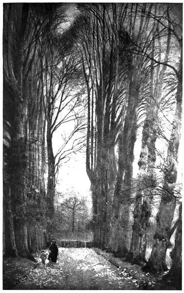
There is apparently no reason why it should not have followed its otherwise invariable rule of taking the southerly slope, and it could have chosen the dry clean air of the heath and kept all the way near the fresh water of the Tillingbourne. On the other hand, there is no doubt whatever of its direction. Tradition, the existence of modern tracks, and more important still, the direction of the road after it leaves St. 'Martha's' chapel, all point to the same conclusion. The Pilgrim's Way crosses diagonally the field beyond the main road, goes just behind the little cottage at its corner, 23and then makes for Albury Park by way of a wretched and difficult sunken lane to the north of Weston Wood. We entered this neglected and marshy way. It was a place of close, dark, and various trees, full of a damp air, and gloomy with standing water in the ruts: the whole an accident differing in tone from all that we knew of the road, before and after.
It was not long in passing. We left the undergrowth for the open of a field, and found the trace of the road pointing to the wall of Albury Park. It entered just north of the new church, and then followed a clearly marked ridge upon which, here and there, stood the yews.
A PLACE OF CLOSE DARK AND VARIOUS TREES, FULL OF A DAMP AIR, AND GLOOMY WITH STANDING WATER-RUTS
After the Old Road enters Albury Park there is a doubtful section of about a mile and a half. The 25-inch Ordnance for Surrey (revised eight years ago) carries the track southward at a sharp angle, round the old church of SS. Peter and Paul and then along the south of Shere till it stops suddenly at a farm called 'Gravel Pits Farm.' It seemed to us as we overlooked the valley from the north, that the Old Road followed a course now included in the garden of Albury, and corresponding, perhaps, to the Yew Walk which Cobbett has rendered famous, and so reached the ford which crosses the Tillingbourne at the limits of the park—a ford still called 'Chantry' ford, and evidently the primitive crossing-place of the stream.
Thence it probably proceeded, as we did, along that splendid avenue of limes which is the mark of the village of Shere. But from the end of this there are some three hundred yards of which one cannot be very certain. It comes so very near to the church that one may presume, without too much conjecture, that it passed beside the southern porch. If it did so, it should have crossed the stream again near where the smithy stands to-day, and this double crossing of the stream may be accounted for by the presence of a shrine and of habitation in the oldest times. But if the bridge be taken as an indication (which bridges often are) of the original place where the stream was re-crossed, then the track would have left the church on the right, and would have curved round to become the present high-road to Gomshall. Nothing certain can be made of its passage here, except that the track marked upon the Ordnance map will not fit in with the character of the road. The Ordnance map loses it at Gomshall, finds it again much further on, having turned nearly a right angle and going (for no possible reason) right up to and over the crest of the hills: across Ranmore Common and so to Burford Bridge. The first part of this cannot but be a confusion with the Old Drove Road to London. As for the crossing of the Mole at Burford Bridge we shall see in a moment that the medieval pilgrimage passed the river at this point, but the prehistoric road at a point a mile and more up stream.
Taking into consideration the general alignment of the Old Road, its 'habits,' the pits that mark it, and its crossing-place in the Mole valley, we did not doubt that we should find it again on the hillside beyond Gomshall.
THAT SPLENDID AVENUE OF LIMES
Its track must have crossed the high-road at a point nearly opposite Netley House, and by a slow climb have made for the side of the Downs and for the chalk, which henceforward it never leaves, save under the necessity of crossing a river valley, until it reaches Chilham, sixty miles away.
Читать дальшеИнтервал:
Закладка:
Похожие книги на «The Collected Works of Hilaire Belloc»
Представляем Вашему вниманию похожие книги на «The Collected Works of Hilaire Belloc» списком для выбора. Мы отобрали схожую по названию и смыслу литературу в надежде предоставить читателям больше вариантов отыскать новые, интересные, ещё непрочитанные произведения.


Обсуждение, отзывы о книге «The Collected Works of Hilaire Belloc» и просто собственные мнения читателей. Оставьте ваши комментарии, напишите, что Вы думаете о произведении, его смысле или главных героях. Укажите что конкретно понравилось, а что нет, и почему Вы так считаете.