Unmanned Aerial Vehicles for Internet of Things (IoT)
Здесь есть возможность читать онлайн «Unmanned Aerial Vehicles for Internet of Things (IoT)» — ознакомительный отрывок электронной книги совершенно бесплатно, а после прочтения отрывка купить полную версию. В некоторых случаях можно слушать аудио, скачать через торрент в формате fb2 и присутствует краткое содержание. Жанр: unrecognised, на английском языке. Описание произведения, (предисловие) а так же отзывы посетителей доступны на портале библиотеки ЛибКат.
- Название:Unmanned Aerial Vehicles for Internet of Things (IoT)
- Автор:
- Жанр:
- Год:неизвестен
- ISBN:нет данных
- Рейтинг книги:4 / 5. Голосов: 1
-
Избранное:Добавить в избранное
- Отзывы:
-
Ваша оценка:
Unmanned Aerial Vehicles for Internet of Things (IoT): краткое содержание, описание и аннотация
Предлагаем к чтению аннотацию, описание, краткое содержание или предисловие (зависит от того, что написал сам автор книги «Unmanned Aerial Vehicles for Internet of Things (IoT)»). Если вы не нашли необходимую информацию о книге — напишите в комментариях, мы постараемся отыскать её.
The book covers cover such subjects as:
Efficient energy management systems in UAV based IoT networks IoE enabled UAVs Mind-controlled UAV using Brain-Computer Interface (BCI) The importance of AI in realizing autonomous and intelligent flying IoT Blockchain-based solutions for various security issues in UAV-enabled IoT The challenges and threats of UAVs such as hijacking, privacy, cyber-security, and physical safety.
Unmanned Aerial Vehicles for Internet of Things (IoT) — читать онлайн ознакомительный отрывок
Ниже представлен текст книги, разбитый по страницам. Система сохранения места последней прочитанной страницы, позволяет с удобством читать онлайн бесплатно книгу «Unmanned Aerial Vehicles for Internet of Things (IoT)», без необходимости каждый раз заново искать на чём Вы остановились. Поставьте закладку, и сможете в любой момент перейти на страницу, на которой закончили чтение.
Интервал:
Закладка:
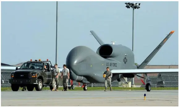
Figure 1.6RQ-4 Global Hawk—Heavy Strategic Military Drone [38].
UAV technologies cover everything from the aerodynamics of the drone, materials used in the manufacture of the physical UAV, to the circuit boards, chipset, and software, which are the brains of the drone. The fast pace of UAV technology is tremendous.
UA is made of light composite material for increased maneuverability and reduced weight. This allows the military drones to cruise at extremely high altitudes. These materials are highly-complex composites, lightweight, strong, durable at the same time and they help in the absorption of vibration and reduces the sound produced. They are also equipped with the state-of-the-art technology such as precise and accurate GPS, laser, infrared cameras, etc as shown in Figure 1.6. Drones are controlled remotely by remote ground control also referred to as a ground cockpit.
1.3.3.1 Firmware—Platform Construction and Design
A firmware platform construction and design for small-scale UAV research is important. As open-source autopilot systems with much reliability (e.g. ArduPilot) were not publicly available until 2009. Most of the researchers’ groups have to start from scratch to build a reliable UAV firmware platform as shown in Figure 1.7. Fixed-wing and rotor types are conventional, therefore the Flight control System (FCS) in this firmware mainly consists of the above platforms [3].
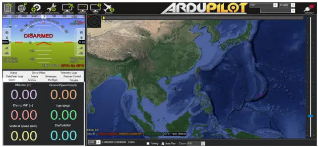
Figure 1.7Representation of GUI configuration of ArduPilot open-source platform.
1.3.4 Comparison of Various Technologies
1.3.4.1 Drone Types & Sizes
UAVs have a much wider variety of sizes and vary according to the need. The largest one is being used for military purposes such as the MQ-4 Triton, built by Northrop Grumman, Raytheon and L3 Comm, the MQ-4 is 47.6 feet long with a wingspan of 130.9 feet, giving it a span wider than a Boeing 737 airliner. The next in size is unmanned aircraft, which have fixed wings and require short runways or sometimes catapult. These are generally used to cover a larger area of land, for geographical mapping, surveying, or to combat wildlife poaching and numerous other examples. These are mainly used for commercial or civil purposes. VTOL drones on the other hand have the endurance of fixed-wing type and vertical take-off quality like quadcopter which makes it more suitable for a job where there is not much space for landing e.g., in hilly areas.
1.3.4.2 Radar Positioning and Return to Home
Most drones are equipped with GPS but now the latest drones have dual Global Navigation Satellite Systems (GNSS) [13] such as GPS [14] and GLONASS [3] (Global Orbiting Navigation Satellite System, Russian). Drones can fly in both non-satellite mode and GNSS mode. For example, DJI drones can fly in P-Mode (GPS and GLONASS) or ATTI mode, which don’t use GPS. Highly accurate drone navigation is important while flying, as it has immense importance in drone applications such as surveying the landscape, SAR (Search and Rescue) missions, and creating 3D maps.
When the quadcopter is switched on its navigation satellite searches and detects GNSS satellite. High-end GNSS systems use satellite Constellation Technology. A satellite constellation is a group of satellites working together in near proximity and sync with one another giving coordinated coverage. This is done in such a way that these satellites overlap an area and is well in coverage. Here, pass or coverage is referred to as the period in which a satellite is visible above the local horizon.
1.3.4.3 GNSS on Ground Control Station
RADAR displays the below data on the remote control display:
1. Signals that adequate GNSS satellite signals are detected and the drone is ready to fly.
2. Displays the current location and position or orientation of a drone in accordance with the controller.
3. Records the home-point for the ‘Return to Home’ safety feature.
The return-to-home safety feature can be pilot initiated by pressing the button on the remote controller or in an application/software, also it can be automatically triggered when the battery is low as a failsafe whenever there is a loss of contact between remote controller and UAV, then UAV will fly back automatically to its home point. The latest technology drone has obstacle avoidance technology while returning home.
1.3.4.4 Collision Avoidance Technology and Obstacle Detection
Modern drones are now equipped with a collision-avoidance system. They use sensors/cameras or scanners to scan their surroundings, while SLAM (Simultaneous Localization & Mapping) technology produces 3D maps from real-time images allowing them to involve in real-time to sense and avoid. SLAM is an extremely important technology when it comes to drones, robots and cars in detecting and avoiding obstacles. Through the combined feedback of the sensors the drone’s sense and avoid, there are:
1 1. Monocular Vision
2 2. Vision Sensor
3 3. Ultrasonic Sensor
4 4. Time-of-Flight (ToF)
5 5. Infrared
6 6. LIDAR.
Drones these days have obstacle avoidance sensors on all six sides. They use both infrared and vision sensors which are then fused into the vision system and this technique is known as Omni-directional obstacle sensing [3]. It senses an object then flies around the obstacle, avoiding any collision and can also do the same when flying in the opposite direction. Also, it can hover if it isn’t possible to pass the obstacle. This technology is known as APAS (Advanced Pilot Assistance System).
1.3.4.5 Gyroscopic Stabilization, Flight Controllers and IMU
Gyroscopic stabilization technology gives the UAV drone its smooth flying capabilities. The gyroscope works almost instantly to the forces moving against the drone, keeping it flying or hovering smoothly. It provides essential navigational information to the flight controller.
The IMU (Inertial Measurement Unit) detects the current rate of acceleration using one or more accelerometers. The IMU detects the changes in rotational attributes like pitch, yaw, and roll using one or more gyroscopes. Sometimes a magnetometer is also used with the IMU to assist with calibration against orientation drift. Gyroscope is a component of IMU and IMU is an essential component of the Flight controller which is the central brain of the drone.
1.3.4.6 UAV Drone Propulsion System
The propulsion system with which drones fly in any direction or hover includes BLDC motors (Brushless DC motor), ESC (Electronic Speed Controller), and propellers. It varies according to the different types of platforms. In a quadcopter, the motor and propellers work in pairs with two motors & propellers placed alternatively one pair rotating clockwise (CW propellers), the other two motors rotate counter-clockwise (CCW Propellers). Similarly, in Hex three motors/propellers pair and in Oct four motors/propellers pair. These BLDC motors receive the electric signal from ESC which receives the signal from the flight controller which in turn receives the signal from the radio transmitter. Together they signal motor speed, braking, monitoring, and fault tolerance.
Apart, from this combustion-derived propulsion is also used in UAV mostly in a fixed-wing platform where some of them use a mini Turbojet engine to cruise at a higher speed. These fast jet mini UAVs have achieved speed as high as 700 km/h and even more. It uses ECU (Engine Control Unit) which comes along with actuators and some sensors and is directly connected to the fuel supply line of the combustion chamber to control the speed of the Turbojet engine.
Читать дальшеИнтервал:
Закладка:
Похожие книги на «Unmanned Aerial Vehicles for Internet of Things (IoT)»
Представляем Вашему вниманию похожие книги на «Unmanned Aerial Vehicles for Internet of Things (IoT)» списком для выбора. Мы отобрали схожую по названию и смыслу литературу в надежде предоставить читателям больше вариантов отыскать новые, интересные, ещё непрочитанные произведения.


Обсуждение, отзывы о книге «Unmanned Aerial Vehicles for Internet of Things (IoT)» и просто собственные мнения читателей. Оставьте ваши комментарии, напишите, что Вы думаете о произведении, его смысле или главных героях. Укажите что конкретно понравилось, а что нет, и почему Вы так считаете.