David Turner - Geology and Mineralogy of Gemstones
Здесь есть возможность читать онлайн «David Turner - Geology and Mineralogy of Gemstones» — ознакомительный отрывок электронной книги совершенно бесплатно, а после прочтения отрывка купить полную версию. В некоторых случаях можно слушать аудио, скачать через торрент в формате fb2 и присутствует краткое содержание. Жанр: unrecognised, на английском языке. Описание произведения, (предисловие) а так же отзывы посетителей доступны на портале библиотеки ЛибКат.
- Название:Geology and Mineralogy of Gemstones
- Автор:
- Жанр:
- Год:неизвестен
- ISBN:нет данных
- Рейтинг книги:5 / 5. Голосов: 1
-
Избранное:Добавить в избранное
- Отзывы:
-
Ваша оценка:
Geology and Mineralogy of Gemstones: краткое содержание, описание и аннотация
Предлагаем к чтению аннотацию, описание, краткое содержание или предисловие (зависит от того, что написал сам автор книги «Geology and Mineralogy of Gemstones»). Если вы не нашли необходимую информацию о книге — напишите в комментариях, мы постараемся отыскать её.
Geology and Mineralogy of Gemstones Volume highlights include:
Concepts in mineralogy Structure and chemical composition of minerals Geological processes that lead to the formation and movement of gemstones Equipment and tools used to examine gemstones and their physical properties Description of small- and large-scale methods of gemstone mining The American Geophysical Union promotes discovery in Earth and space science for the benefit of humanity. Its publications disseminate scientific knowledge and provide resources for researchers, students, and professionals.
Geology and Mineralogy of Gemstones — читать онлайн ознакомительный отрывок
Ниже представлен текст книги, разбитый по страницам. Система сохранения места последней прочитанной страницы, позволяет с удобством читать онлайн бесплатно книгу «Geology and Mineralogy of Gemstones», без необходимости каждый раз заново искать на чём Вы остановились. Поставьте закладку, и сможете в любой момент перейти на страницу, на которой закончили чтение.
Интервал:
Закладка:
In general, most geological activity (such as earthquakes, volcanic activity, and mountain building) that affects the surface of the Earth occurs at the plate boundaries while the central portions of the plates tend to be quite “stable” and experience little larger scale geological activity. The three main types of plate boundaries are convergent, divergent, and transform ( Figure 2.4).
Divergent plate boundaries occur where tectonic plates move away from each other and new crust is produced. An example of a constructive divergent plate boundary is the Mid‐Atlantic Ridge. This geological feature has been widening the Atlantic Ocean at an average rate of about 2.5 cm per year (this rate varies along its length). It is notable in that it is also one of the few ocean ridges that can be observed on land in Iceland. Divergent boundaries can also form within a continental plate (such as the East Africa Rift) and may ultimately form a new ocean basin.
Convergent boundaries occur where two plates move toward each other and collide ( Figure 2.5). The Himalayan mountain range was formed when two continental plates, the Indian and Eurasian plates, collided (continental–continental collision). Intense pressures and temperatures are produced during these collisions and the rocks within the plates are affected accordingly. When two oceanic plates or an oceanic plate and a continental plate collide, one plate is pushed under or subductedbelow the other. Chains of inland volcanoes or volcanic islands often develop above and parallel to these zones of subduction, such as what is seen today along the Japanese island arc system and Cascade volcanic arc. In the case of oceanic–continental plate collision, the oceanic plate is always subducted below the continental plate because oceanic crust is denser than continental material.
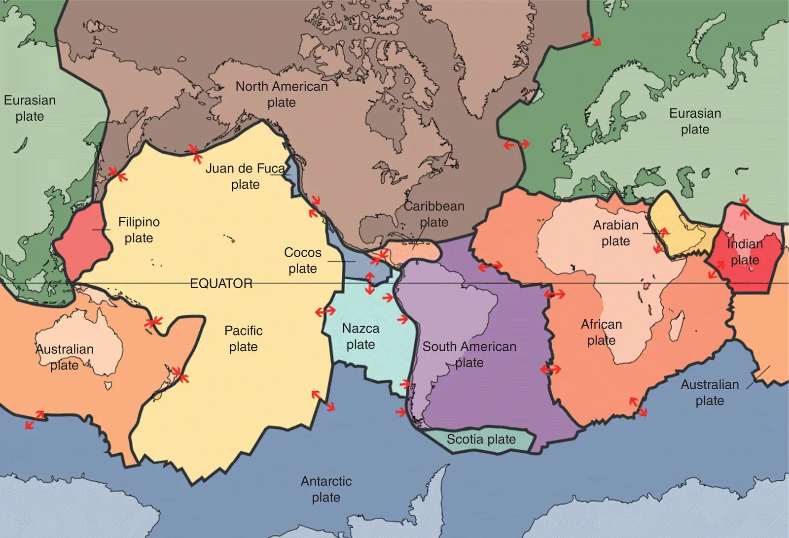
Figure 2.3 The major tectonic plates of the Earth, their boundaries, and relative motions (red arrows). U.S. Geological Survey / Public domain.
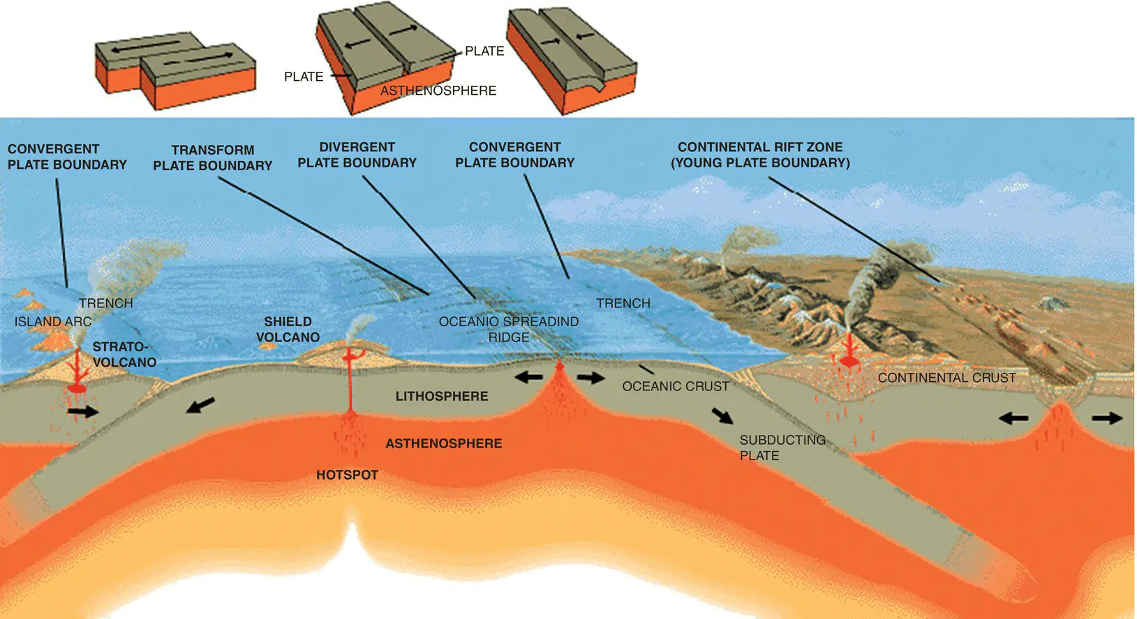
Figure 2.4 This cross‐section illustrates the main types of plate boundaries: convergent, divergent, and transform. U.S. Geological Survey / Public domain.
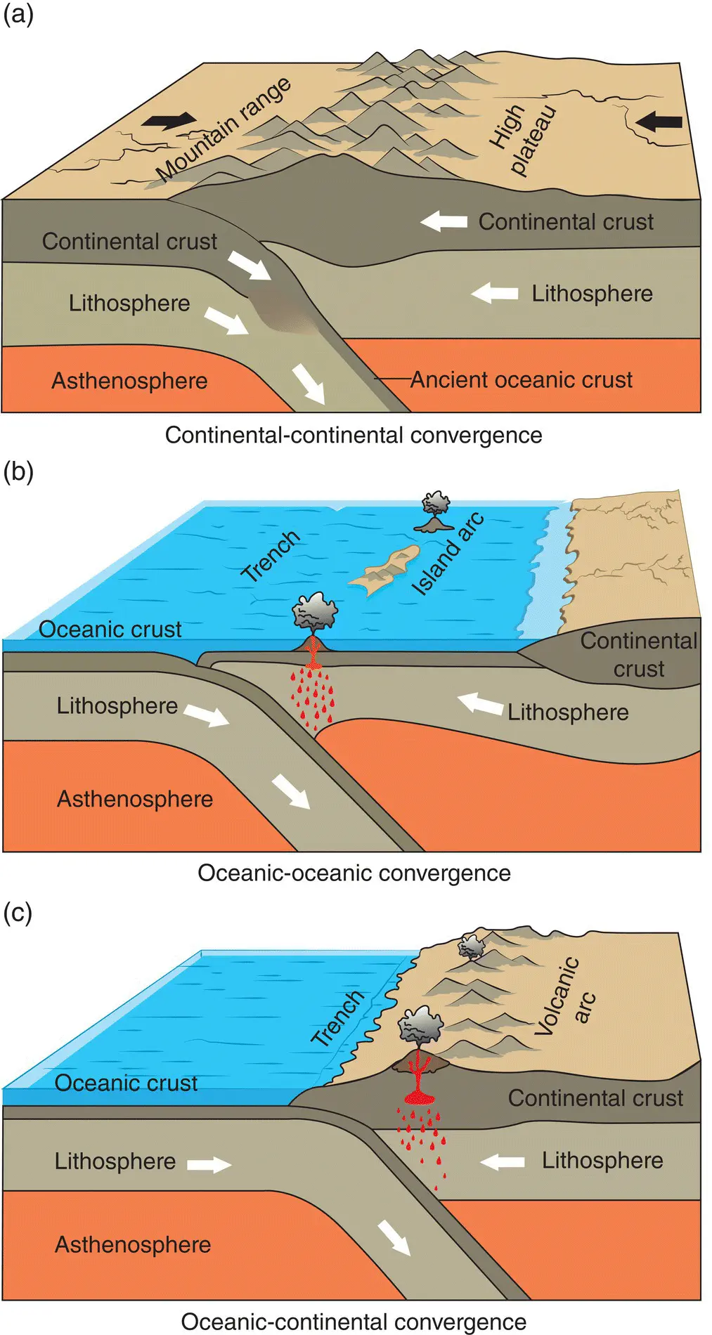
Figure 2.5 Schematic diagrams of (a) continental–continental convergent plate boundary, (b) oceanic–oceanic convergence, and (c) oceanic–continental plate convergence. U.S. Geological Survey / Public domain.
Transform boundaries are characterized by the plates moving past each other without the creation or significant destruction of crustal material ( Figure 2.6). The most famous transform plate boundary is coincident with the feature known as the San Andreas Fault where the North American Plate is moving past the Pacific Plate.
The thickness of the world’s crust varies in time and space as geological processes incessantly march forward. Figure 2.7, from the U.S. Geological Survey, is a map of the world with the thickness of the crust mapped out – each line traces areas of equal thickness (measured in kilometers) with the colors corresponding to altitude of the Earth's surface. Roughly, the continents and their margins are outlined by the 30 km contour. Continental crust with a thickness greater than 50 km is rare and accounts for less than 10% of the continental crust. Total continental crust thickness is important for understanding the distribution of certain gem deposits, such as diamondiferous kimberlites or high‐grade metamorphic terranes formed via continental–continental collisions.
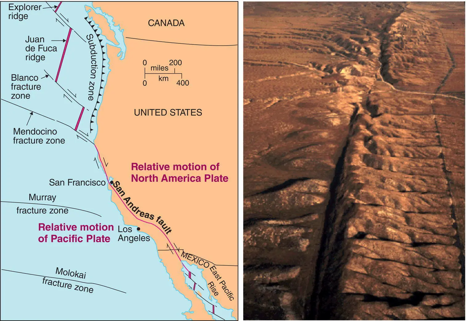
Figure 2.6 Map and aerial view of the San Andreas Fault that cuts across the Carrizo Plain. The San Andreas Fault is well known for being an active geological structure that is easily observed at the surface. The many fracture zones provide relief from tectonic stresses applied to the Pacific Plate in this complex area. The thicker purple lines delineate extensional environments and volcanism at the sea floor (e.g., Juan de Fuca Ridge). U.S. Geological Survey / Public domain.
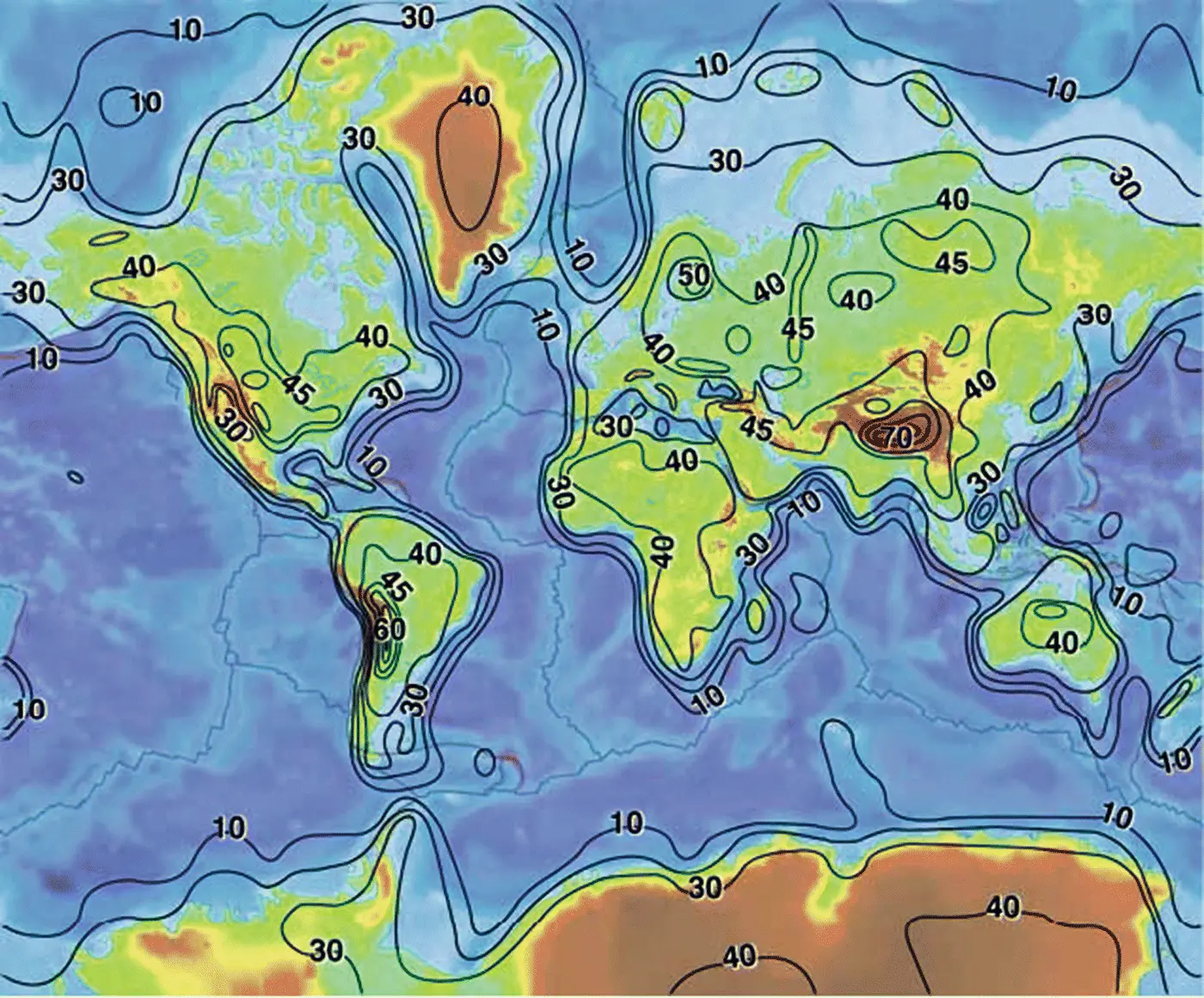
Figure 2.7 Thickness contour map of the of the Earth's crust, developed from the CRUST 5.1 model with a contour interval of 10 km with greater detail on the continents above 45 km thickness. Colors indicate surface elevation above average sea level (blue = below sea level, green = low lying, yellow = mid elevation, brown = high elevation). U.S. Geological Survey / Public domain.
2.3 General Rock Types and the Rock Cycle
The basic threefold classification of rocks is igneous, sedimentary, and metamorphic. The textural, mineralogical,and geochemical characteristics of these rocks lead to specific nomenclature for describing and classifying them; these are summarized in Figures 2.8, 2.9, 2.10, and 2.11for more common rocks.
Igneous rocks crystallize (a process sometimes called solidification) from a molten material (called a melt or magma); the rock is composed of interlocking minerals. Magmas are generated from partial melting of mantle material or of rocks deep in the crust. If this melt flows out and cools to form a rock at the surface of the Earth, it is called volcanic or extrusive. If the melt cools and solidifies inside the Earth, it is called plutonic or intrusive.
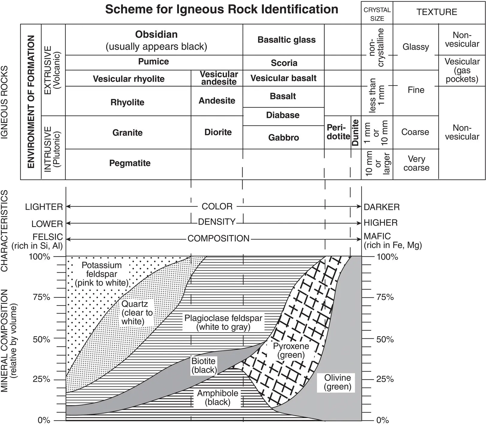
Figure 2.8 Simple and generalized classification diagram for igneous rocks, based on dominant rock forming mineral composition. On the right are igneous rocks with high magnesium and iron content, which are termed “mafic”, such as extrusive basalt with fine grained crystal sizes or intrusive gabbro with coarse crystal sizes. Basalt will be composed predominantly of plagioclase and pyroxene, with variable amounts of olivine, amphibole, and biotite as well as other lesser minerals such magnetite, depending on the specific geological setting. Schematic from Wikimedia Commons.
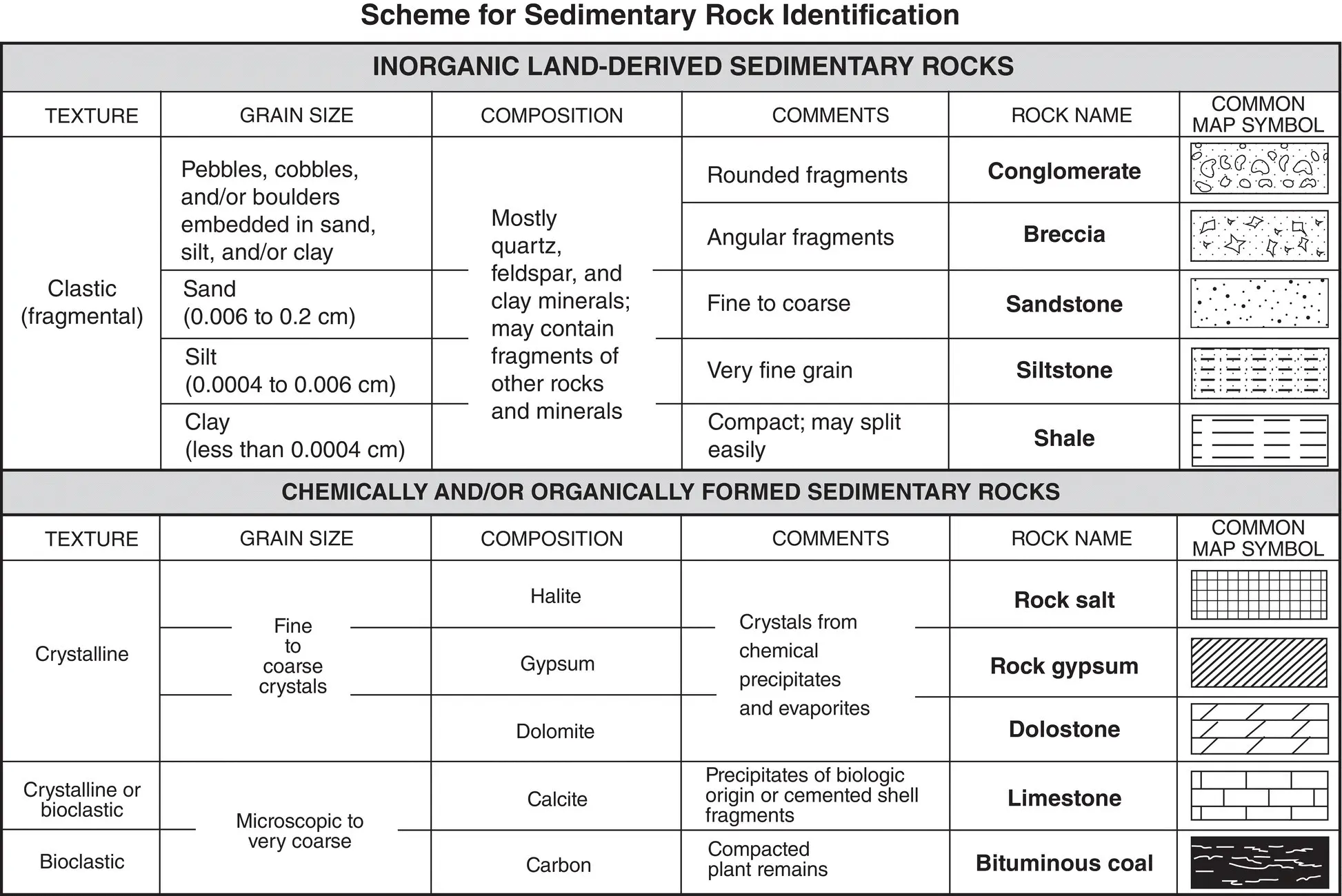
Figure 2.9 Simple and generalized classification diagram for sedimentary rocks. First order classification is carried out on texture, and then on grain sizes and compositions of the material. Schematic from ESProjects under Creative Commons.
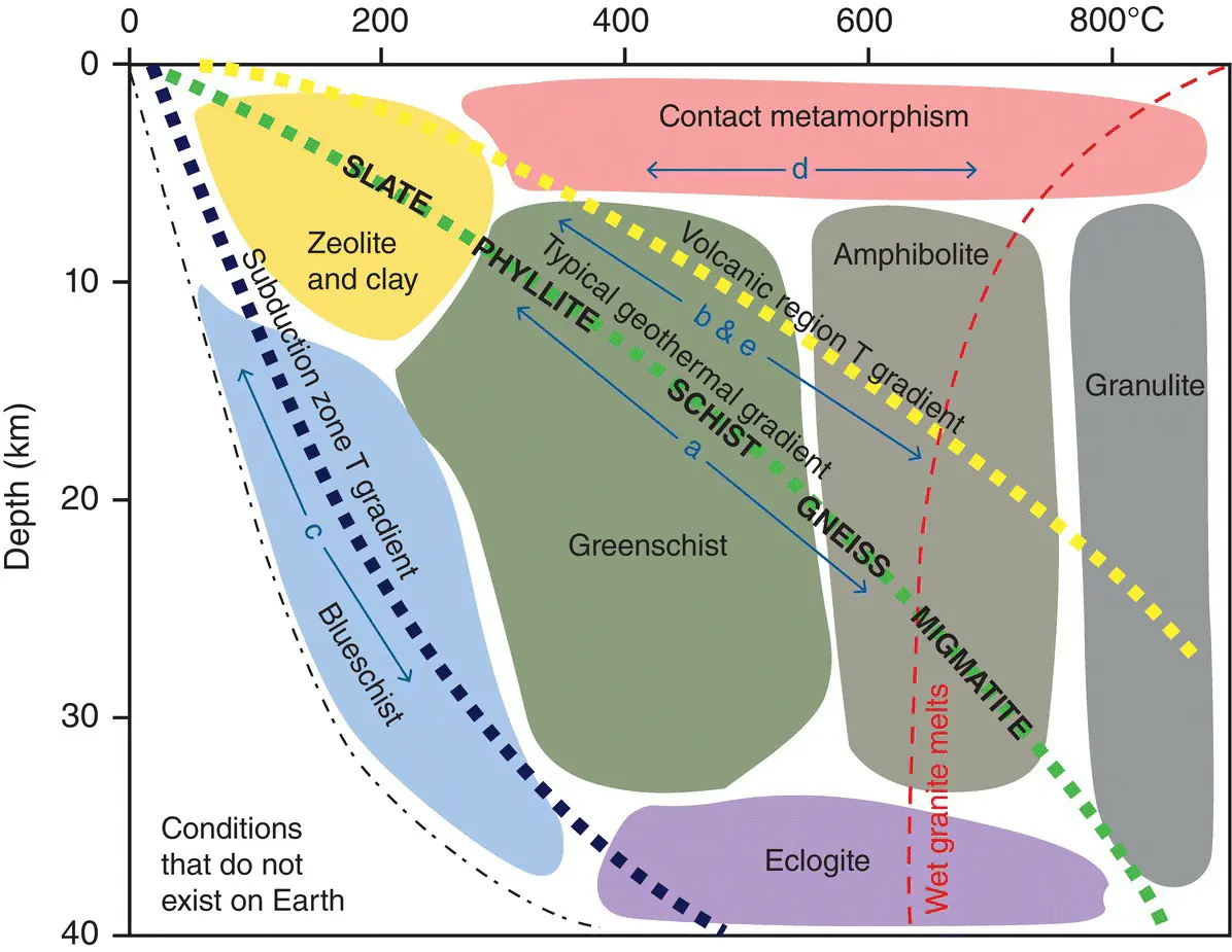
Figure 2.10 Simple diagram for metamorphic rocks based on changing temperature (T) and pressure (P) conditions as a function of depth. The green dashed line (a) depicts the typical path of a mudrock being buried and enduring prograde (increasing P and T) metamorphism, transforming into slate, then subsequently into phyllite, schist, gneiss, and, finally, starting to melt as it becomes a migmatite. The yellow line (b & e) indicates conditions in proximity to volcanic centers, while (d) represents the region immediately adjacent to igneous magma and rocks at shallow depths, often termed “contact metamorphism”. The blue dashed line (c) represents the low‐temperature / high‐pressure path that a mudrock might take if subducted alongside cold basalts at a convergent margin. The red dashed line at high temperatures indicates a region where granitic rocks will start to melt. Earle (2015) / CC BY 4.0.
Читать дальшеИнтервал:
Закладка:
Похожие книги на «Geology and Mineralogy of Gemstones»
Представляем Вашему вниманию похожие книги на «Geology and Mineralogy of Gemstones» списком для выбора. Мы отобрали схожую по названию и смыслу литературу в надежде предоставить читателям больше вариантов отыскать новые, интересные, ещё непрочитанные произведения.


Обсуждение, отзывы о книге «Geology and Mineralogy of Gemstones» и просто собственные мнения читателей. Оставьте ваши комментарии, напишите, что Вы думаете о произведении, его смысле или главных героях. Укажите что конкретно понравилось, а что нет, и почему Вы так считаете.