Alan Weisman - The World Without Us
Здесь есть возможность читать онлайн «Alan Weisman - The World Without Us» весь текст электронной книги совершенно бесплатно (целиком полную версию без сокращений). В некоторых случаях можно слушать аудио, скачать через торрент в формате fb2 и присутствует краткое содержание. Город: New York, Год выпуска: 2007, ISBN: 2007, Издательство: Thomas Dunne Books, Жанр: sci_ecology, sci_popular, на английском языке. Описание произведения, (предисловие) а так же отзывы посетителей доступны на портале библиотеки ЛибКат.
- Название:The World Without Us
- Автор:
- Издательство:Thomas Dunne Books
- Жанр:
- Год:2007
- Город:New York
- ISBN:978-0-312-34729-1
- Рейтинг книги:5 / 5. Голосов: 1
-
Избранное:Добавить в избранное
- Отзывы:
-
Ваша оценка:
The World Without Us: краткое содержание, описание и аннотация
Предлагаем к чтению аннотацию, описание, краткое содержание или предисловие (зависит от того, что написал сам автор книги «The World Without Us»). Если вы не нашли необходимую информацию о книге — напишите в комментариях, мы постараемся отыскать её.
EDITORIAL REVIEW: Time Entertainment Weekly Finalist for the 2007 National Book Critics Circle Award
Salon Amazon Top 100 Editors’ Picks of 2007 (#4)
Barnes and Noble 10 Best of 2007: Politics and Current Affairs
Kansas City Star Mother Jones South Florida Sun-Sentinel Hudson St. Louis Post-Dispatch St. Paul Pioneer Press
The World Without Us — читать онлайн бесплатно полную книгу (весь текст) целиком
Ниже представлен текст книги, разбитый по страницам. Система сохранения места последней прочитанной страницы, позволяет с удобством читать онлайн бесплатно книгу «The World Without Us», без необходимости каждый раз заново искать на чём Вы остановились. Поставьте закладку, и сможете в любой момент перейти на страницу, на которой закончили чтение.
Интервал:
Закладка:
Today, that brew of clay, sand, and a paste made of the calcium of ancient seashells hardens into a man-made rock that is increasingly the most affordable option for Homo sapiens urbanus. What happens, then, to the cement cities now home to more than half the humans alive?
Before we consider that, there’s a matter to address regarding climate. If we were to vanish tomorrow, the momentum of certain forces we’ve already set in motion will continue until centuries of gravity, chemistry, and entropy slow them to an equilibrium that may only partly resemble the one that existed before us. That former equilibrium depended on a sizeable amount of carbon locked away beneath Earth’s crust, much of which we’ve now relocated into the atmosphere. Instead of rotting, the wood frames of houses may be preserved like the timbers of Spanish galleons wherever rising seas pickle them in salt water.
In a warmer world, the deserts may grow drier, but the parts where humans dwelled will likely again be visited by what attracted those humans in the first place: flowing water. From Cairo to Phoenix, desert cities rose where rivers made arid soils livable. Then, as population grew, humans seized control of those aquatic arteries, diverting them in ways that allowed for even more growth. But after people are gone, the diversions will soon follow them. Drier, hotter desert climates will be complemented by wetter, stormier mountain weather systems that will send floods roaring downstream, overwhelming dams, spreading over their former alluvial plains, and entombing whatever was built there in annual layers of silt. Within them, fire hydrants, truck tires, shattered plate glass, condominia, and office buildings may remain indefinitely, but as far from sight as the Carboniferous Formation once was.
No memorial will mark their burial, though the roots of cottonwoods, willows, and palms may occasionally make note of their presence. Only eons later, when old mountains have worn away and new ones risen, will young streams cutting fresh canyons through sediments reveal what once, briefly, went on here.
CHAPTER 3

The City Without Us
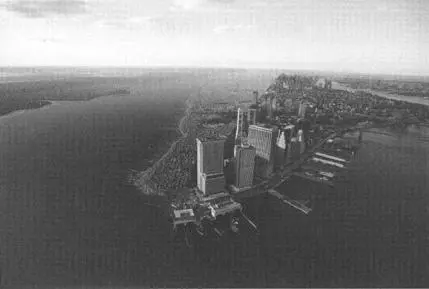
THE NOTION THAT someday nature could swallow whole something so colossal and concrete as a modern city doesn’t slide easily into our imaginations. The sheer titanic presence of a New York City resists efforts to picture it wasting away. The events of September 2001 showed only what human beings with explosive hardware can do, not crude processes like erosion or rot. The breathtaking, swift collapse of the World Trade Center towers suggested more to us about their attackers than about mortal vulnerabilities that could doom our entire infrastructure. And even that once-inconceivable calamity was confined to just a few buildings. Nevertheless, the time it would take nature to rid itself of what urbanity has wrought may be less than we might suspect.
IN 1939, A World’s Fair was held in New York. For its exhibit, the government of Poland sent a statue of Władysław Jagiełło. The founder of the Białowieża Puszcza had not been immortalized in bronze for preserving a chunk of primeval forest six centuries earlier. By marrying its queen, Jagiełło had united Poland and his duchy of Lithuania into a European power. The sculpture portrays him on horseback following his victory at the Battle of Grünwald in 1410. Triumphant, he hoists two swords captured from Poland’s latest vanquished enemy, the Teutonic Knights of the Cross.
In 1939, however, the Poles weren’t faring so well against some descendants of those Teutonic Knights. Before the New York World’s Fair ended, Hitler’s Nazis had taken Poland, and the sculpture couldn’t be returned to its homeland. Six sad years later, the Polish government gave it to New York as a symbol of its courageous, battered survivors. The statue of Jagiełło was placed in Central Park, overlooking what today is called Turtle Pond.
When Dr. Eric Sanderson leads a tour through the park, he and his flock usually pass Jagiełło without pausing, because they are lost in another century altogether—the 17th. Bespectacled under his wide-brimmed felt hat, a trim beard graying around his chin and a laptop jammed in his backpack, Sanderson is a landscape ecologist with the Wildlife Conservation Society, a global squadron of researchers trying to save an imperiled world from itself. At its Bronx Zoo headquarters, Sanderson directs the Mannahatta Project, an attempt to re-create, virtually, Manhattan Island as it was when Henry Hudson’s crew first saw it in 1609: a pre-urban vision that tempts speculation about how a posthuman future might look.
His team has scoured original Dutch documents, colonial British military maps, topographic surveys, and centuries of assorted archives throughout town. They’ve probed sediments, analyzed fossil pollens, and plugged thousands of bits of biological data into imaging software that generates three-dimensional panoramas of the heavily wooded wilderness on which a metropolis was juxtaposed. With each new entry of a species of grass or tree that is historically confirmed in some part of the city, the images grow more detailed, more startling, more convincing. Their goal is a block-by-city-block guide to this ghost forest, the one Eric Sanderson uncannily seems to see even while dodging Fifth Avenue buses.
When Sanderson wanders through Central Park, he’s able to look beyond the half-million cubic yards of soil hauled in by its designers, Frederick Law Olmstead and Calvert Vaux, to fill in what was mostly a swampy bog surrounded by poison oak and sumac. He can trace the shoreline of the long, narrow lake that lay along what is now 59th Street, north of the Plaza Hotel, with its tidal outlet that meandered through salt marsh to the East River. From the west, he can see a pair of streams entering the lake that drained the slope of Manhattan’s major ridgeline, a deer and mountain lion trail known today as Broadway.
Eric Sanderson sees water flowing everywhere in town, much of it bubbling from underground (“which is how Spring Street got its name”). He’s identified more than 40 brooks and streams that traversed what was once a hilly, rocky island: in the Algonquin tongue of its first human occupants, the Lenni Lenape, Mannahatta referred to those now-vanished hills. When New York’s 19th-century planners imposed a grid on everything north of Greenwich Village—the jumble of original streets to the south being impossible to unsnarl—they behaved as if topography were irrelevant. Except for some massive, unmoveable schist outcrops in Central Park and at the island’s northern tip, Manhattan’s textured terrain was squashed and dumped into streambeds, then planed and leveled to receive the advancing city.
Later, new contours arose, this time routed through rectilinear forms and hard angles, much as the water that once sculpted the island’s land was now forced underground through a lattice of pipes. Eric Sanderson’s Mannahatta Project has plotted how closely the modern sewer system follows the old watercourses, although man-made sewer lines can’t wick away runoff as efficiently as nature. In a city that buried its rivers, he observes, “rain still falls. It has to go somewhere.”
Читать дальшеИнтервал:
Закладка:
Похожие книги на «The World Without Us»
Представляем Вашему вниманию похожие книги на «The World Without Us» списком для выбора. Мы отобрали схожую по названию и смыслу литературу в надежде предоставить читателям больше вариантов отыскать новые, интересные, ещё непрочитанные произведения.


Обсуждение, отзывы о книге «The World Without Us» и просто собственные мнения читателей. Оставьте ваши комментарии, напишите, что Вы думаете о произведении, его смысле или главных героях. Укажите что конкретно понравилось, а что нет, и почему Вы так считаете.