Carroll Quigley - The Evolution of Civilizations
Здесь есть возможность читать онлайн «Carroll Quigley - The Evolution of Civilizations» весь текст электронной книги совершенно бесплатно (целиком полную версию без сокращений). В некоторых случаях можно слушать аудио, скачать через торрент в формате fb2 и присутствует краткое содержание. Год выпуска: 101, Издательство: Liberty Fund Inc., Жанр: Старинная литература, на английском языке. Описание произведения, (предисловие) а так же отзывы посетителей доступны на портале библиотеки ЛибКат.
- Название:The Evolution of Civilizations
- Автор:
- Издательство:Liberty Fund Inc.
- Жанр:
- Год:101
- ISBN:нет данных
- Рейтинг книги:5 / 5. Голосов: 1
-
Избранное:Добавить в избранное
- Отзывы:
-
Ваша оценка:
The Evolution of Civilizations: краткое содержание, описание и аннотация
Предлагаем к чтению аннотацию, описание, краткое содержание или предисловие (зависит от того, что написал сам автор книги «The Evolution of Civilizations»). Если вы не нашли необходимую информацию о книге — напишите в комментариях, мы постараемся отыскать её.
Like the course, The Evolution of Civilizations is a comprehensive and perceptive look at the factors behind the rise and fall of civilizations.
Quigley defines a civilization as "a producing society with an instrument of expansion." A civilization's decline is not inevitable but occurs when its instrument of expansion is transformed into an institution—that is, when social arrangements that meet real social needs are transformed into social institutions serving their own purposes regardless of real social needs.
The Evolution of Civilizations — читать онлайн бесплатно полную книгу (весь текст) целиком
Ниже представлен текст книги, разбитый по страницам. Система сохранения места последней прочитанной страницы, позволяет с удобством читать онлайн бесплатно книгу «The Evolution of Civilizations», без необходимости каждый раз заново искать на чём Вы остановились. Поставьте закладку, и сможете в любой момент перейти на страницу, на которой закончили чтение.
Интервал:
Закладка:
A collision between this civilization, which is early in Stage 3, and Western civilization, which has just begun Stage 4, would probably be indecisive in its outcome. If Western civilization reforms and again passes into Stage 3, it will be far too powerful to be defeated by Russian civilization; if Western civilization does not reform, but continues through the Stage of Conflict into the Stage of Universal Empire, the threat from Russian civilization will be much greater. However, by that time the new Indian civilization or the new Chinese civilization may be in Stage 3 and will present greater threats to both Western and Russian civilizations than either of these will present to the other. The possible, but by no means inevitable, relationships of these four civilizations in terms of the relevant stages can be seen from the following chart.
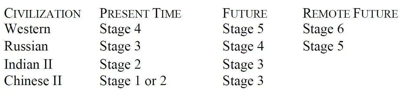
This chart is purely guesswork, because if Western civilization reforms in the Present Time (as appears highly likely), or if any revolutionary new technological discovery (such as the conquest of photosynthesis) is made in the near future, this whole relationship will be modified.
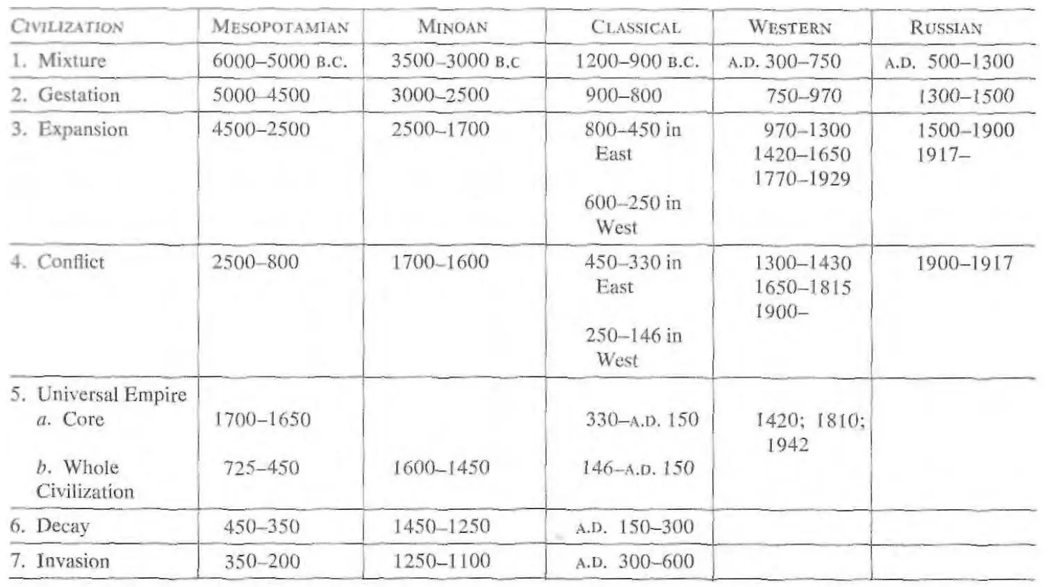
Returning from the unknown future to the partially known past, we can conclude this chapter by a chart that gives, in a rough fashion, the chronology of the seven stages for the civilizations with which we shall be most concerned.
6. The Matrix of Early Civilizations
We have already said that civilizations are like crystals, which are frequently distorted by efforts to share the same crystalline material. They are also distorted by the noncrystalline material or "matrix" in which they are embedded. The matrix source from which diamonds are derived is great cylindrical pipes of friable blue clay that rise vertically from the remote depths of the earth to just below the surface. In this clay the diamonds are found embedded like currants in a fruitcake. Of course the diamonds in a "pipe" of blue clay are much less frequent than the currants in any acceptable piece of cake. In this they are like civilizations, which are very infrequent occurrences in a matrix of time, space, and noncivilized cultures.
The matrix in which civilizations occur is five-dimensional just as culture is. These include the same three dimensions of space, the fourth dimension of time, and the fifth dimension of abstraction. Before we make any serious attempt to apply the seven stages of civilization, we should have a somewhat clearer idea of this matrix in order to understand the distorting influences it may exercise on the seven stages of normal evolution in a civilization.
The three dimensions of space in which a civilization is found include its geographic environment. Since we are primarily interested in our own Western civilization and its direct predecessors rather than in the New World or the Far Eastern civilizations, we shall speak here only of the geographic matrix in which Western civilization arose. This area, including Europe, northern Africa, and western Asia, was aptly called the "Northwest Quadrant" by the historian James Henry Breasted. Bounded on the south by the Sahara Desert along the line of latitude 20°N. and on the east by the northeast-running line of the Pamir, Tien Shan, and Altai Mountains, its western and northern frontiers are formed by the great arc of the Atlantic and Arctic Oceans. Within this great quadrant the land mass of Afro-Eurasia has the form of a letter "L" which has been rotated in a clockwise direction a quarter turn. The apex of this figure lies in the northwest, in Europe, while one limb runs eastward into Asia and the other limb runs southward into Africa. Europe's position at the apex of these two lines has made it a mixing area, with the African influences more important in the prehistoric period and the Asiatic influences more important in the historic period. This mixing role of Europe has been modified also by the extreme diversity of Europe's terrain, which has given it a very convoluted coast line, creating numerous inland seas and semiisolated valleys that give onto the sea. The result of these two geographic influences has been to give Europe great diversity of both geographic conditions and cultural influences in a small area.
The Northwest Quadrant falls into three zones, flatlands in the north and south being separated by the east-west spine of the Highland Zone. The Highland Zone is a broken sequence of mountains and plateaus from the Pyrenees through the Alps, Apennines, Balkan highlands, Carpathian Mountains, Anatolian Plateau, Caucasus, and Iranian Plateau to the Himalayas and the line of highlands that form the eastern boundary of the Northwest Quadrant. North of this Highland Zone lie the Northern Flatlands, which begin as a narrow wedge in the Netherlands and run eastward across the Northwest Quadrant, widening steadily as they move eastward so that they are only a couple of hundred miles wide in western Europe but broaden to almost two thousand miles wide in Asia.
The Southern Flatlands are opposite in pattern to the Northern Flatlands since they are broadest in the extreme west and are narrower in northeastern Africa and Arabia, finally falling below sea level in the extreme east to form the bottoms of the Arabian Sea and Indian Ocean.
This simple, and oversimplified, three-zone pattern of the Northwest Quadrant is complicated by a number of other features of which the most obvious are the inland seas, rivers, and mountain passes. One of the chief of these features is the Mediterranean Sea, which runs east and west just south of the Highland Zone. The geographic significance of the Mediterranean Sea, of course, is that it divides Europe from Africa, but its cultural significance is distinctly different because it has served to link its shores together rather than to divide them. This binding influence of the Mediterranean in the cultural sphere lasted for over 4,000 years, from the first establishment of distant maritime travel about 3500 B.C. to the Arab conquest of North Africa and the Near East about A.D. 700. During this period the techniques of water transportation were far more efficient and cheaper than the techniques of land travel. This superiority of movement by water continued for more than a thousand years after the Arab conquest, the technological lag of land travel beginning to close only with the invention of the macadam road, the coach, and the railroad after 1750. In the thousand or more years after 700, the linking influence of superior maritime communication in the Mediterranean was counterweighed by the cultural division between Moslem culture on its southern and eastern shores and Christian culture on its northern and western shores; but in the four thousand years before the Arabic conquest the technological factor was not counteracted by any profound cultural differences, and the shores tended to be drawn together by marine communication into a single cultural system. At that time the cultural division was not along the Mediterranean Sea but on the mountain barrier running parallel to it to the north. Classical civilization, especially as it grew into the Roman Empire, was the culmination of these influences. They were reflected in the term "Our Sea" {Mare nostrum), applied by the Romans to the Mediterranean, while the peoples north of the mountains (who were biologically closer relatives but culturally remote) were called "barbarians" for most of the Classical period.
Less obvious than the Mediterranean were other geographical features of the Northwest Quadrant, especially those serving as interregional connections. Of these links two of the more significant were the "Syrian Saddle" and the "Vardar-Morava route." The Syrian Saddle is the low pass across the Lebanon and Anti-Lebanon Mountains around the northern edge of the Syrian Desert just at the point where the Euphrates River approaches closest to the Mediterranean Sea. The mountains and deserts surrounding this "saddle" make it the only feasible route connecting the Aegean, the Mediterranean, and Egypt to the west with Mesopotamia and the Persian Gulf to the east.
Читать дальшеИнтервал:
Закладка:
Похожие книги на «The Evolution of Civilizations»
Представляем Вашему вниманию похожие книги на «The Evolution of Civilizations» списком для выбора. Мы отобрали схожую по названию и смыслу литературу в надежде предоставить читателям больше вариантов отыскать новые, интересные, ещё непрочитанные произведения.


Обсуждение, отзывы о книге «The Evolution of Civilizations» и просто собственные мнения читателей. Оставьте ваши комментарии, напишите, что Вы думаете о произведении, его смысле или главных героях. Укажите что конкретно понравилось, а что нет, и почему Вы так считаете.