Detailed Expert Analysis of the MH17 Downing
Здесь есть возможность читать онлайн «Detailed Expert Analysis of the MH17 Downing» весь текст электронной книги совершенно бесплатно (целиком полную версию без сокращений). В некоторых случаях можно слушать аудио, скачать через торрент в формате fb2 и присутствует краткое содержание. Год выпуска: 2014, Жанр: military_weapon, Публицистика, на английском языке. Описание произведения, (предисловие) а так же отзывы посетителей доступны на портале библиотеки ЛибКат.

- Название:Detailed Expert Analysis of the MH17 Downing
- Автор:
- Жанр:
- Год:2014
- ISBN:нет данных
- Рейтинг книги:4 / 5. Голосов: 1
-
Избранное:Добавить в избранное
- Отзывы:
-
Ваша оценка:
Detailed Expert Analysis of the MH17 Downing: краткое содержание, описание и аннотация
Предлагаем к чтению аннотацию, описание, краткое содержание или предисловие (зависит от того, что написал сам автор книги «Detailed Expert Analysis of the MH17 Downing»). Если вы не нашли необходимую информацию о книге — напишите в комментариях, мы постараемся отыскать её.
It is a huge pleasure for me to submit to you a detailed analysis made by “CDN” of the circumstances of the downing of MH17.
You will notice that CDN’s analysis does not agree with
. The difference being that CDN does have the professional expertise (accident investigation) to write such a report while I do not. Still, CDN has specifically asked me to “
” which I indeed encourage you to do: his analysis does not pretend to be The One And Only Truth but instead a basis for discussion.
You can download his full report by clicking on either one of the following links:
https://drive.google.com/file/d/0ByibNV3SiUoobnpCVDduaHVORHM/edit?usp=sharing http://www.mediafire.com/view/61qa99yt6v3dq64/MH17Analysis_Parts_1_and_2.pdf I am getting increasingly frustrated and angry at the fact that clearly the Dutch and the British, obviously under the orders of Uncle Sam, are sitting on the data of the flight data recorders and not releasing them. At the very least, the following countries have the recordings of the radio contacts between MH17 and the Kiev ATC:
1) The junta’s SBU
2) The USA
3) Russia
and then two more countries — France and Switzerland — which probably have them too. Even if these recordings are destroyed, there are enough people out there who by now who know what happened. The truth will come out sooner or later. In the meantime, the main task is not to discover The One And Only Truth, but first to disprove the complex of lies of the Empire and, then, to gradually get close and closer to the truth.
We all owe a huge debt of gratitude to CDN who produced a professional-grade report and made it available for us for the sole reward of advancing the cause of truth and justice. I am personally deeply grateful to CDN for choosing this blog to release his report.
I ask you all to share with us your comments, especially your critical ones, to make it possible for CDN to refine his analysis. This would be the best way to thank him for his truly excellent work. The Saker
Posted by
Detailed Expert Analysis of the MH17 Downing — читать онлайн бесплатно полную книгу (весь текст) целиком
Ниже представлен текст книги, разбитый по страницам. Система сохранения места последней прочитанной страницы, позволяет с удобством читать онлайн бесплатно книгу «Detailed Expert Analysis of the MH17 Downing», без необходимости каждый раз заново искать на чём Вы остановились. Поставьте закладку, и сможете в любой момент перейти на страницу, на которой закончили чтение.
Интервал:
Закладка:
A mixed load of explosive and incendiary rounds is normally fed in an alternating sequence. Any incendiary cannon fire that reached the cockpit area would likely have ignited a fire. The video image of the aircraft descent shows no sign of fire until after aircraft impact with the ground.
Aircraft cannon normally fire in bursts in order to place a cloud of lead on the target and ensure a hit. The damaged port side cockpit fuselage clearly shows evidence of multiple impacts. Why is it that the port wing surface shows only a single bullet graze?
The port wing graze also serves to rule out a missile fired from Mayak. Image 13 shows the direction shrapnel would have taken if fired from a position on the aircraft beam. Since the missile is designed to explode above with the shrapnel blasting down, it is evident that a missile interception from the Mayak position would have caused damage to the wing surfaces and likely ignited a fireball at altitude. Witness reports indicate the plane breaking up in the sky but they do not report a fireball.
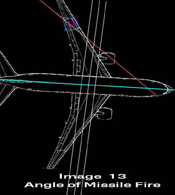
Image 14 shows the approximate direction of missile shrapnel if the missile had been fired from the UAF Buk position in Avdiika. Again, since the missile is designed to explode high and project shrapnel down and forward, an interception from Avdiika would likely have destroyed the tailplane and adjacent surfaces. Imagery from the debris field shows these aircraft components to be largely intact and unmarked.
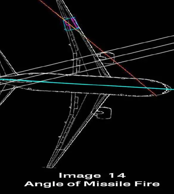
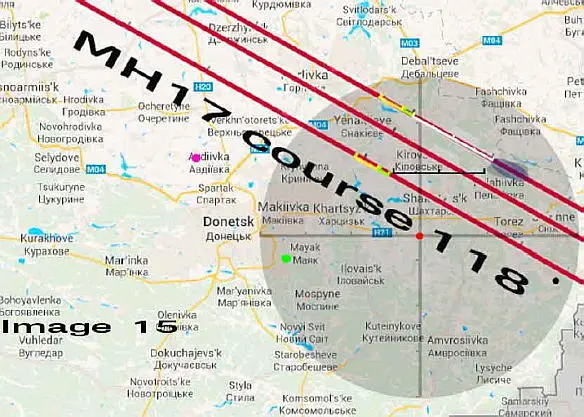
Image 15 shows that a missile at the Shakhtars’k position remains capable of an interception even if the course track is displaced to the Northeast. While the course of 118 degrees was reported by flight tracking services, the exact alignment of this track in relation to the ground has been subject to various interpretations.
Image 15 shows all possible variations. The lower of the three course lines represents MH17 passing to the south of Horlivka. The middle track represents MH17 passing directly over Horlivka, while the most northerly track represents an alternate alignment with the extant debris field. In each instance an interception by the Buk position south of Shakhtars’k is possible. Note that in each case the missile would intercept on the starboard side of the cockpit.
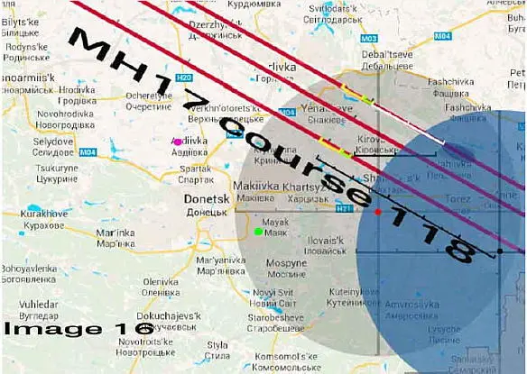
When the Telegraph site is superimposed on the map (see Image 16) it is clear that a Buk TELAR deployed at Snizhne would not have been able to intercept MH17 at the calculated point of missile impact. If a Buk TELAR was located exactly at Snizhne it would have intercepted MH17 in a head on position. The resulting damage would be very different from the observed damage.
No evidence has been offered to show that the rebels captured a complete Buk M-1 system. What evidence does exist suggests rebel capture of a single TELAR from a Ukrainian military facility in Donetsk. There is no evidence that this captured system was in working condition. Most military forces are trained to destroy, or disable, equipment about to fall into enemy hands. It is therefore highly likely the TELAR captured by the rebels was inoperative. This explains why it was immediately moved east rather than being deployed to protect Donetsk from air attack. There is no evidence to suggest the rebels acquired a Buk search radar unit, or a Buk command post vehicle.
Lacking search radar capability, a Buk TELAR deployed at the Telegraph ’s reported position south of Snizhne would have a maximum radar search radius of 42 km. Its radar would be unable to see any aircraft beyond this distance. As image 16 shows, MH17 was struck by a missile when it was more than 50 km from the Telegraph ’s Snizhne position. At 33,000 feet, MH17 would not have been visible to the naked eye. The aircraft would not have been audible. The question which needs to be asked is “How did the rebels manage to identify a potential target outside the acquisition range of a Buk TELAR radar, and beyond the limits of visual range?” Perhaps the rebels are telepathic. Even if the rebels had telepathic powers, the range of the Buk missile is limited to a 35 km radius. If it was an older system (and much of the Ukrainian equipment is old, outdated, and in poor repair) the missile range would have been limited to 30 km. The damage evident from debris field images does not match the damage expected to be caused by a missile impact from directly ahead, or from slightly to port.
Finally, if a missile had been fired from a position close to Snizhne, it is likely the citizens of Snizhne would have observed and photographed either the missile launch, or the missile emplacement. The fact of the captured Buk’s passage east has been well documented. Why are there no images of the rebel missile and its impressive launch contrail? Why is it that neither the BBC, nor the Telegraph reporters, both of whom undertook extensive surveys of Snizhne, and the area south of Snizhne, were unable to locate a single local eyewitness to the alleged missile launch events?
The reason no evidence was found was because the missile that downed MH17 was not fired from Snizhne.
SECTION 5
Speculations
In closing I wish to present two thoughts and one final image. Saker has previously presented his interpretation of the available crash data. This report contains my interpretation of the same data. Both interpretations likely contain flaws and both are likely to be amended as more information becomes available. I have attempted to present the evidence as accurately as I can and I welcome any critique or additional information presented in the comments section. That is the first thought.
Image 17 is provided courtesy of the US military.
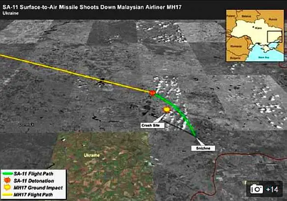
The US military operates with an annual budget that exceeds the combined budgets of all other military forces worldwide. The US armed forces are awash in money, personnel, and equipment. In addition to overhead imagery available from reconnaissance satellites and from a drone squadron reported to be operating in Ukraine, the US military also fields satellites with infrared detectors as part of the Defense Support Program. These IR sensitive satellites are expressly designed to give immediate warning of any missile launches. These satellites are reported to be sufficiently sensitive that they are able to detect hot spots within forest fires. Despite these various advanced technical capabilities the only imagery released by the US military comes in the form of the cartoon shown in Image 17.
The citizens of the world must pay attention to the fact that the US has not provided any reasonable means to assist in the identification of the perpetrators of the MH17 shoot down. The bulk of its “evidence” consists of a rehash of what is found on social media. And much of what is found on social media has been shown to be forged by the Ukrainian Security Service and Ministry of the Interior.
When the neo-Nazis in Ukraine overthrow a democratically elected government, the west does nothing but rant against Putin. When the unelected government of Ukraine launches air strikes, MLRS Grad launches, and ballistic missile strikes against its own civilian population in Donbass, the west does nothing but rant against Putin. When the Kiev neo-Nazis burn people alive in Odessa, shoot them down as they attempt to escape the flames, and rape a pregnant woman before strangling her with a telephone cord, the west does nothing but rant against Putin.
Читать дальшеИнтервал:
Закладка:
Похожие книги на «Detailed Expert Analysis of the MH17 Downing»
Представляем Вашему вниманию похожие книги на «Detailed Expert Analysis of the MH17 Downing» списком для выбора. Мы отобрали схожую по названию и смыслу литературу в надежде предоставить читателям больше вариантов отыскать новые, интересные, ещё непрочитанные произведения.


Обсуждение, отзывы о книге «Detailed Expert Analysis of the MH17 Downing» и просто собственные мнения читателей. Оставьте ваши комментарии, напишите, что Вы думаете о произведении, его смысле или главных героях. Укажите что конкретно понравилось, а что нет, и почему Вы так считаете.