Avijit Gupta - Introducing Large Rivers
Здесь есть возможность читать онлайн «Avijit Gupta - Introducing Large Rivers» — ознакомительный отрывок электронной книги совершенно бесплатно, а после прочтения отрывка купить полную версию. В некоторых случаях можно слушать аудио, скачать через торрент в формате fb2 и присутствует краткое содержание. Жанр: unrecognised, на английском языке. Описание произведения, (предисловие) а так же отзывы посетителей доступны на портале библиотеки ЛибКат.
- Название:Introducing Large Rivers
- Автор:
- Жанр:
- Год:неизвестен
- ISBN:нет данных
- Рейтинг книги:5 / 5. Голосов: 1
-
Избранное:Добавить в избранное
- Отзывы:
-
Ваша оценка:
Introducing Large Rivers: краткое содержание, описание и аннотация
Предлагаем к чтению аннотацию, описание, краткое содержание или предисловие (зависит от того, что написал сам автор книги «Introducing Large Rivers»). Если вы не нашли необходимую информацию о книге — напишите в комментариях, мы постараемся отыскать её.
Introducing Large Rivers Introducing Large Rivers
Introducing Large Rivers — читать онлайн ознакомительный отрывок
Ниже представлен текст книги, разбитый по страницам. Система сохранения места последней прочитанной страницы, позволяет с удобством читать онлайн бесплатно книгу «Introducing Large Rivers», без необходимости каждый раз заново искать на чём Вы остановились. Поставьте закладку, и сможете в любой момент перейти на страницу, на которой закончили чтение.
Интервал:
Закладка:
Source: Meade 2007 with details in Dunne et al. 1998.
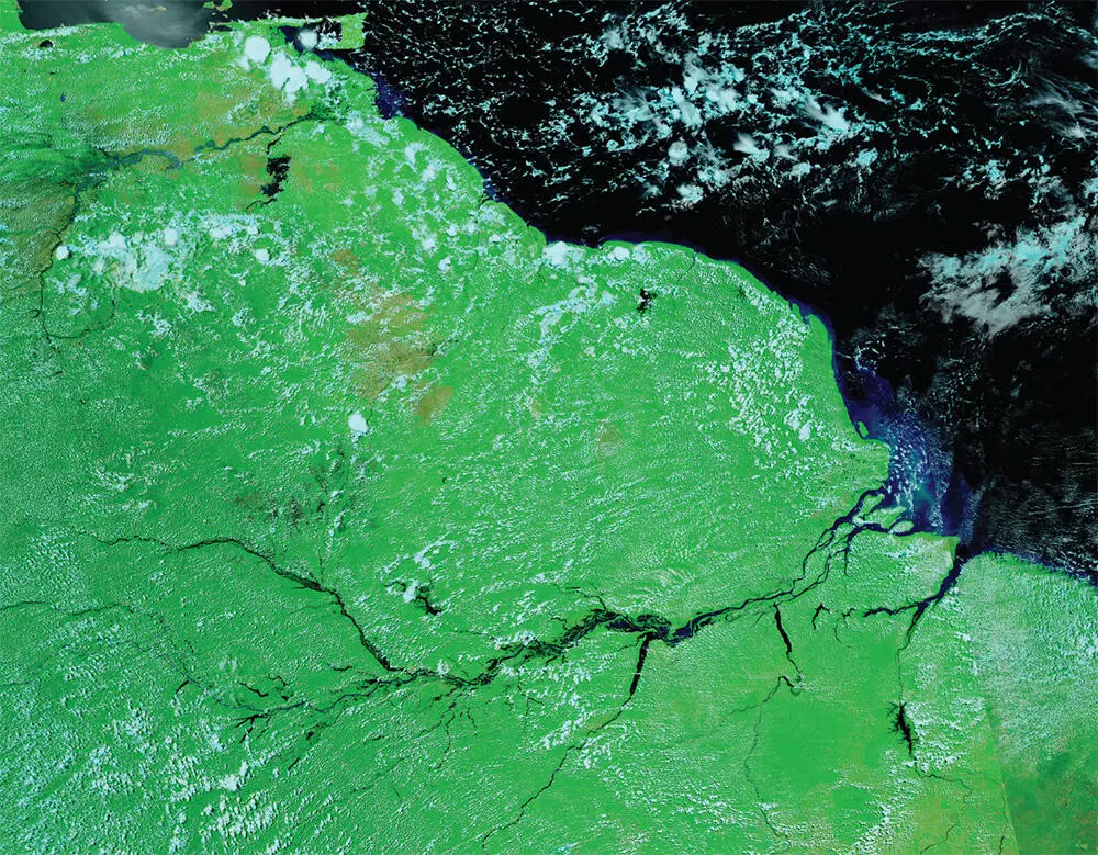
Figure 3.4 Satellite image showing plumes of sediment entering the Atlantic from the Amazon mouth and then moving northeast along the coast to build part of the Orinoco Delta.
Source: NASA worldview application ( https://worldview.earthdata.nasa.giv), part of the NASA Earth Observatory System Data and Information System (EOSDIS).
Depending on texture, fluvial sediment can be transported as dissolved load in solution, in suspension through the water column, and as bed load moving in traction along the river bottom. Dissolved load is finer than 0.62 μm. Suspended load, which is coarser than 0.62 μm, is often described in two parts: wash load (the finer fraction of suspended load that nearly always remains in suspension) and bed material load (the material which is carried by eddies only in high flow). The coarser part of the suspended load can be picked up from the bed and transported in suspension when the power of the river increases. Sand for example can be transported both as suspended and bed load. The coarsest material is usually moved discretely along the bed in very high flows, coming to rest on the bed at other times. Pebbles are dragged and rolled downstream as bed load but have been noted to travel in suspension in very big floods. Very coarse material such as cobbles and boulders are carried as bed load, except in extreme floods. Such catastrophic floods occurred when glacial lakes burst in overflows towards the end of the Pleistocene (Baker 1981, 2007). Very large floods, for example those caused by tropical cyclones, have been known to suspend pebbles and cobbles for short distances. This rarely happens, and boulder, cobbles, and pebbles are carried usually as bed load. Sand usually travels as bed load but in floods is often carried suspended by eddies. Silt and clay are transported as suspended load unless in aggregates. When separated, grains of such fine material may be transported either as suspended or dissolved load.
Data for clastic river sediment often only include total suspended load. Bed load is very difficult to measure. For many meandering rivers it is only a few per cent of the total load and considered to be within the margin of error for sampling (Milliman and Meade 1983 citing C. Nordin). This assumption probably does not work for sediment supplied by small mountainous streams or where large rivers cut through mountain ranges. The Brahmaputra, for example, is considered to be a river which carries a higher percentage (probably 30%) of bed load (Goswami 1985; Best et al. 2007).
The removal (erosion) of particles is a function of stream velocity. The critical erosion velocity of a particle is the velocity at which it starts to move. Once sediment grains are entrained, they can be transported with a velocity lower than that for entrainment. A sediment grain being carried either on bed or in water comes to rest (deposition) when the velocity of the river falls below the value needed to carry it. This is the fall velocity, related directly to grain size. Sand is the easiest to erode from the channel perimeter and bars. Pebbles, cobbles, and boulders require a higher critical erosion velocity but as they are bigger and heavier, requiring high fall velocity, they can be transported only for a short time or distance. Sand is carried longer. The critical erosion velocity of silt and clay, sticky and forming aggregates, is higher than sand, but once suspended in water they are transported for a long time and distance (Hjulström 1939).
This pattern of river transport leads to a sorting of material downstream, finer material travelling longer. In large rivers with room for deposition inside the valley, such sorting also happens across large bars and floodplains ( Figure 3.5). The channel of a long river therefore displays pebble, cobbles, and boulders near the mountains and silt and clay near the sea. Sand is ubiquitous, and because of sorting and weathering on bars and floodplains increases in proportion along the channel. The modal size of sand grain, however, decreases downstream. This general pattern persists except where major rivers cross erodible fills or are joined by short tributaries bringing coarse sediment. The anomaly is corrected over a stretch below the confluence with the tributary downstream along the main river. The formation and development of floodplains and sorting of sediment grains across them is discussed by Junk et al. in Chapter 5.
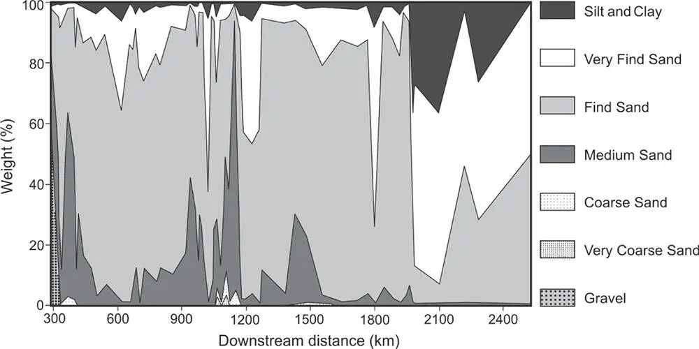
Figure 3.5 The Ganga River. Changes in the grain size of bar material from Hardwar in the Himalayan foothills to Ganga Sagar on the delta. The coarsening of the bars in the middle reach is due to the contribution of southern rivers draining the Indian Peninsular.
Source: Singh 2007.
The total volume of sediment per unit time is considered as sediment load or sediment discharge. Sediment yield is the total load of the river divided by the upstream basin area. This assumption implies uniform load shedding from all parts of the basin which is incorrect as a very large part of the sediment on large rivers may come from the headwaters with high relief. Furthermore, the eroded sediment in the basin is not always transferred efficiently. Only about 10% of the total eroded sediment in the conterminous United States may reach the ocean (Milliman and Farnsworth 2011, referring to Holeman). Wasson et al. (1996) indicated that only about 1% of the entire eroded soil mass reaches the sea in Australia. Sediment discharge also varies with time, changes in vegetation cover, and anthropogenic alterations of the environment. The question of reliability is more relevant for sediment than water discharge. Milliman and Farnsworth (2011) opined that rounded figures are safer to use, attempted precise measurements are likely to be less accurate.
It is difficult to prioritise all the factors behind erosion and sediment supply to large rivers. Certain factors have been discussed by geomorphologists, such as relief, intensity and amount of rainfall, water discharge, the weathered nature of country rock, etc. (Milliman and Farnsworth 2011 and references therein). Numerical models have been proposed to compare the relative importance of such environmental factors for sediment discharge. For example, Syvitski and Milliman (2007) opined that geological factors explain 65% of the variation in sediment load, whereas climate and anthropogenic factors account for another 30%. The importance of these factors, however, vary among rivers, and anthropogenic modifications can significantly modify the natural pattern. For example, a series of dams have considerably reduced the volume of sediment that used to flow into the Mississippi River from the basin of its west bank tributary, the Missouri (as discussed in Chapter 8) .Hovius and Leeder (1998) discussed the difficulty of establishing a reliable universal relationship between certain characteristics of drainage basins and sediment production. The difficulty arises mainly because of the varying importance of a series of tectonic, climatic and geomorphic processes, all three working in an integrated fashion to determine the sediment of a drainage basin.
The data sets used for these conclusions may include measurements from hundreds of rivers but not exclusively from large rivers. We therefore may not only need to prioritise certain basin properties for all rivers but also determine the relative contribution of individual smaller rivers and sum them to construct the total discharge of a specific large river. High young fold mountains, such as the Himalaya or Andes, are directly associated with high sediment discharge because of tectonics. Older ranges such as the Rockies or the Urals produce less sediment because of lack of tectonics and hardness of the older rocks. The orographic effect on precipitation adds to enhanced discharge increasing both runoff and sediment discharge of such streams. Briefly, the sediment discharge of large rivers increases directly with relief, lithology, tectonics, precipitation, and basin area.
Читать дальшеИнтервал:
Закладка:
Похожие книги на «Introducing Large Rivers»
Представляем Вашему вниманию похожие книги на «Introducing Large Rivers» списком для выбора. Мы отобрали схожую по названию и смыслу литературу в надежде предоставить читателям больше вариантов отыскать новые, интересные, ещё непрочитанные произведения.


Обсуждение, отзывы о книге «Introducing Large Rivers» и просто собственные мнения читателей. Оставьте ваши комментарии, напишите, что Вы думаете о произведении, его смысле или главных героях. Укажите что конкретно понравилось, а что нет, и почему Вы так считаете.